Historical Information
The northern South Island is known as Te Tau Ihu, the prow of the waka from which the demigod Māui fished up the North Island. Marlborough is strongly associated with the earliest period of settlement in Aotearoa. Early Polynesian settlers—migrants from Hawaiki in East Polynesia—inhabited Te Pokohiwi/the Wairau Bar in the thirteenth century.
Successive migrations of people were drawn to the region’s rich resources. Earlier tribes were largely displaced by Ngāti Kuia and Ngāti Mamoe in the sixteenth century, with Ngāti Mamoe dominating the Wairau. Later in the century, groups of Rangitāne moved southwards from the Hawke’s Bay via Wairarapa, while Ngāti Apa migrated across from the Rangitīkei district. Rangitāne eventually consolidated their position in the Wairau and in the 1700s created an 18-kilometre network of channels amongst the estuarine coastal lagoons. This massive engineering feat served them to harness the already plentiful mahinga kai resources, including fish, eels and birds. In the 1820s a whaling industry centred on Cook Strait was established, with Māori working, trading and intermarrying with Pākehā whalers at shore whaling stations in the Marlborough region.
Between 1828-1832 the settled alliances of the region were unbalanced when a war party of Kawhia and Taranaki warriors armed with muskets attacked numerous pā. This caused great losses among the local populations, especially Rangitāne and Ngāti Apa. Ngāti Toa Rangatira put down roots in the Wairau and one of their warrior chiefs, Te Rauparaha, dominated affairs in the region; Ngāti Rārua also settled along the Wairau River. In October 1839 it was primarily with Ngāti Toa that William Wakefield negotiated to purchase large tracts of land for the New Zealand Company, who needed the rural arable pastures of the Wairau Valley to support their colony at Nelson.
Ownership and possession of the Wairau was still in dispute in 1842 when the New Zealand Company persisted with surveying the valley, despite Te Tau Ihu chiefs’ denial of Ngāti Toa’s claims to the area, and Te Rauparaha’s insistence that the Wairau land was excluded from the Company’s purchase. The unrest erupted into violence on 17 June 1843, when a posse of settlers tried to arrest Te Rauparaha and his nephew Te Rangihaeata in retaliation for their disruption of the surveying. The confused fighting resulted in the deaths of around 25 people, including victims from both groups.
Shockwaves from this tragedy, today referred to as the ‘Wairau Incident’, were felt locally and nationally, and attempts to secure the Wairau slowed until after Commissioner Spain’s 1845 inquiry into the land claims of the Nelson area found that the Wairau District had not been included in the 1839 sale. By various devious and underhand coercive tactics the Crown finally wrested possession of the Wairau from Ngāti Toa in 1847, and the valley was divided into allotments.
The 2008 Waitangi Tribunal inquiry report, and subsequent Treaty of Waitangi settlements, acknowledged the Crown’s failure to protect iwi rights and interests in its methods of acquisition of Wairau land and failure to provide adequate reserve lands, among other breaches. Today Rangitāne o Wairau, Ngāti Rārua and Ngāti Toa Rangatira have principal interests in the Wairau/Blenheim area.
Blenheim emerges from the wetlands
The name of the region’s major river, ‘Wairau’, derives from ‘Ngā wai-rau o Ruatere’, describing the braided waterways across the region, highly important to Māori for providing food and resources such as flax as well as a communication/transport network. The large flax swamp at the convergence of the Ōpaoa and Omaka rivers was described by the area’s Māori name, Te Waiharakeke. This wetland, the future site of Blenheim, also inspired that settlement’s first European name, ‘The Beaver’, said to have been coined by Joseph Ward (1817-1892) when he came across his surveying party ‘[sitting] like a lot of beavers in a dam’ amidst floodwaters.
Blenheim developed in the 1850s. Earthquakes in 1848 and 1855 gave the future settlement a boost (literally and figuratively) as the ground level dropped enough to allow sea-going vessels to sail up the river to the site, increasing its potential as a trading nexus. Merchant James Wynen built a raupo warehouse there sometime soon after 1848. In 1852, James Sinclair and his family became the first to permanently reside there. From 1857 Sinclair was the land agent who marketed the town sections. By 1865 Blenheim was the principal town in the province, with a steadily growing population.
Catholicism in Blenheim
Catholicism in Aotearoa New Zealand grew from the work of missionaries who arrived in Northland in 1838. Bishop Jean-Baptiste Francois Pompallier’s mission was notable for its efforts to form Catholic belief around existing Māori tikanga and disseminate teachings by printing books in the Māori language. The Māori name for Catholicism, ‘Pikopō’ (from ‘episcopal’, meaning ‘of a bishop’), reflects Pompallier’s impact. The missionaries established the Society of Mary’s work in Aotearoa. In 1850 a split between Pompallier and the Society of Mary led to the creation of the Diocese of Wellington, which became the base of the Marist clergy, and included Blenheim.
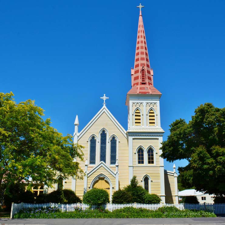
In 1844 the first Catholic missionary visited Marlborough. Father Antoine Garin (1810-1889) was the first Parish Priest, appointed in 1850. However, Father Augustine Sauzeau SM (1834-1898), appointed Marlborough’s Parish Priest in 1864, is considered the founder of the Parish of St Mary. Sauzeau built the first St Mary’s Church on a large site in Blenheim’s Maxwell Road, opened on 26 September 1865. The Blenheim church was part of Sauzeau’s program to establish Catholic facilities in the Marlborough region; the same year he opened the first Catholic School on the Blenheim site. By 1876 a new, larger building was needed to replace the old church. Sauzeau engaged prominent Wellington architect Thomas Turnbull, who designed a substantial timber Gothic building. The new church was opened on 29 September 1878. The first St Mary’s church building was then used as a girls’ school until 1909, then a meeting room until its demolition in 1926.
Housing the Clergy: the Presbytery
The parishioners originally housed Father Sauzeau in a small cottage across Maxwell Road from the present St Mary’s church. After a few years Sauzeau built a new presbytery further along Maxwell Road, across from Dillon Street. This was said to have been ‘in the old style—gabled roofs and very nearly perpendicular staircases.’ By the mid-1880s this building needed enlarging. Father W.J. Lewis arranged to add a new front section whilst retaining part of the original building at the rear for ‘visitors, servants and kitchen’.
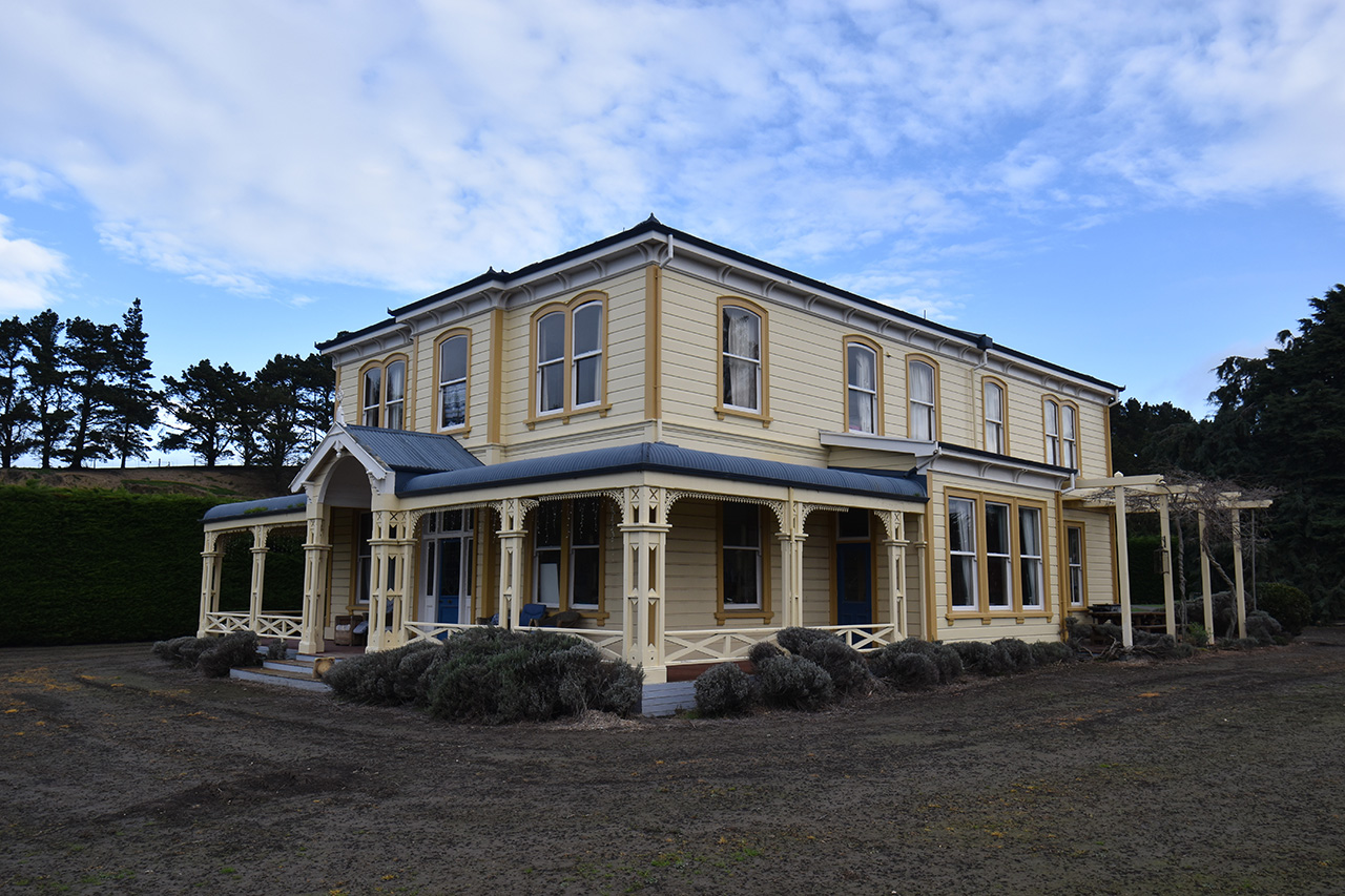
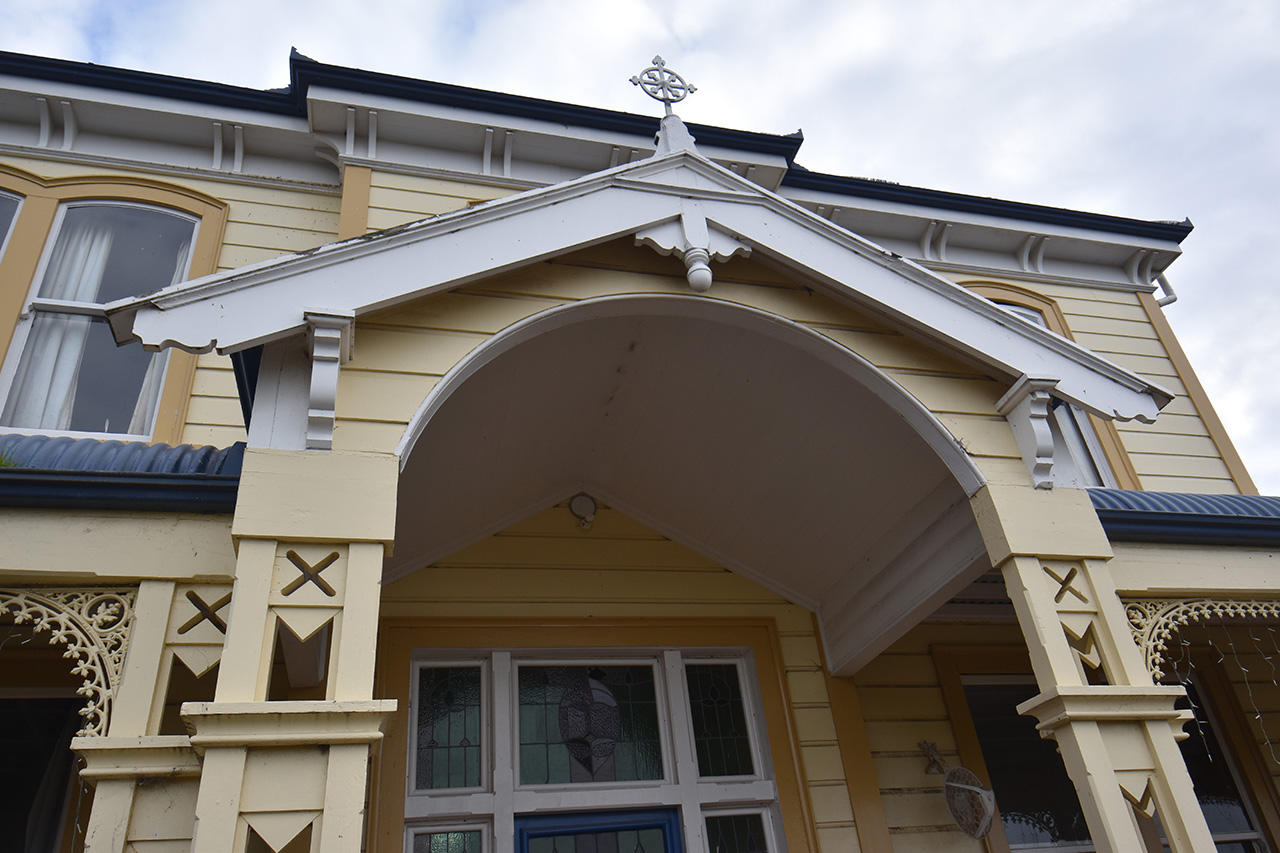
Architect D.A. Douglas called for construction tenders in June 1890. A month later the successful contractor—Mr Jones of Havelock—had commenced dismantling the front portion of the house, and by 26 October the site was ready for the Mayor to lay the foundation stone, installing a time capsule. Construction of the enlarged presbytery was completed by March 1891, in timber. At the time the ground floor layout was described as having a parlour, sitting room, dining room and library, with an 8-foot wide hallway running through the building; upstairs contained another sitting room, four bedrooms and a bathroom. The ‘strikingly handsome’ front elevation in existence today [2022] dates from this time.
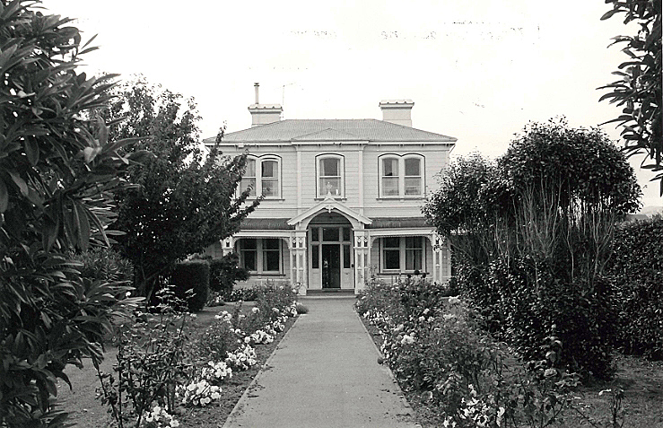
Further substantial alterations were completed in 1911, orchestrated by Father J. Holley. Notable Wellington architect John Sydney Swan’s design replaced the original 1870s rear part of the building with a two-storeyed addition containing three bedrooms, a bathroom and office on the top floor, with kitchen and housekeeper’s flat on the ground floor. The 1891 addition remained at the front, demarcated by the stairway. Swan was, at the time, amidst a series of significant commissions for the Catholic Church in New Zealand, which ultimately included Erskine College, St Gerard’s Church, Our Lady of Compassion Convent in Wellington, Sacred Heart Convent in Whanganui, and St Bede’s School in Christchurch. Two years before his work on the St Mary’s Presbytery he had designed a large addition, including a chapel, for its neighbour on Maxwell Road, St Joseph’s Convent.
Property review 1988-1998: dispersal of the Presbytery and Convent
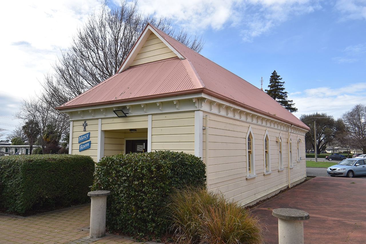
In the late 1980s the Parish Pastoral Council and Parish Priest Father Michael O’Hagan commissioned a wide-ranging review of parish property assets. The goal was to reorganise and concentrate resources on revitalising key assets for the future ‘Beyond 2000’; a result was the rationalising of some of the ageing buildings to raise capital. A scheme for a reordered parish centre on Maxwell Road was devised by architects Calder, Fowler, Styles and Turner, involving major alterations and additions to the church, and construction of a new administration block, hall and presbytery. Despite having been heritage-listed since 1982, the historic presbytery, along with the historic former convent, convent high school building and music room, were earmarked for disposal. Other properties were sold, and some school buildings demolished and rebuilt.
A new life for the old building
In 1996 the old presbytery building was sold to Chris and Trish Redwood and relocated in six sections to the Seddon side of the Awatere River at Seaview. The relocation and rejoining of the building to make it weatherproof apparently took nine days. It was left to settle for two years before the restoration process began following Sir Michael Fowler’s plans, with little change to the building except the installation of an ensuite and new kitchen fixtures. Chimneys were not reinstated but the fireplace surrounds were left in situ. The building was able to be shifted with the verandah intact, so it retains this original and prominent feature of the 1891 façade.
With little alteration since its days as a presbytery, the building continues to serve as the comfortable family home for the Redwoods, whose ancestor Archbishop Francis Redwood (1939-1935) would have likely stayed in the residence on his visits to Blenheim. Archbishop Redwood, the first Roman Catholic Archbishop of the Wellington Archdiocese and one of New Zealand’s longest-serving bishops, is considered a ‘Catholic pioneer’ who contributed much to New Zealand history through his support for the establishment of Catholic facilities and the local missions of the Society of Mary, Sisters of Mercy, Sisters of Compassion, and related orders.
Sir Michael Fowler’s vision for the Maxwell Road Catholic station was fully enacted and St Mary’s Church continues to be its centre, albeit now surrounded by mostly modern buildings, including the attached foyer, Community Centre, new presbytery and administration building. The St Mary’s school buildings have also been modernised to replace the older buildings. The church itself, and the former convent chapel/Mercy Room, are now the oldest buildings on the site. The parish, now known as the Star of the Sea Marlborough (Te Whetu o Te Moana), is grappling with updated seismic strengthening requirements for the St Mary’s Church building and is undertaking another review of parish properties.