

The Nelson region was initially settled from the 1840s as part of the New Zealand Company's planned settlement programme. However, remote areas such as Murchison were slow to develop due to their distance from the nucleus of settlement. Therefore, despite sporadic visits by explorers, and then isolated gold-mining and timber-milling settlements from the mid 1840s, it was not until 1865 that the town was surveyed and formally established. Access continued to be a main impediment to the development of Murchison which meant that until the early twentieth century it was very much a frontier community. However, at this time the fortunes of Murchison changed, which can be seen in the construction of churches and public facilities. The growth of the area and Murchison's developing role as a service town for the local dairy industry led to the establishment of Murchison County. This large area had previously been within the domain of Inangahua County, and the separation meant that the distinct character of the Murchison region was recognised and its needs could be better catered for. In 1950 the Council added the public library to its responsibilities and this was set up in the Council Chambers, and local government administration and library services at the building have continued to the present.
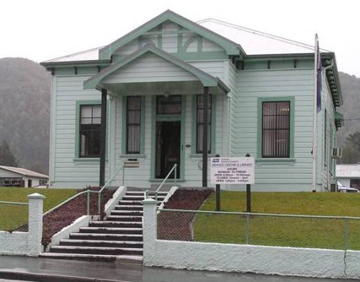
The Council Chambers is a timber framed and rusticated weatherboard clad building typical of its period and function. The Classicism favoured in civic buildings of the time is present, although in a muted form which was reflective of the economic capabilities and size of the local authority it was constructed for. The main body of the building contains a large meeting room with modest office spaces adjoining it to the east and west. There was little alteration to the building until the late twentieth century when an entrance canopy was added and some interior changes undertaken.
The Council Chambers building in Murchison is characteristic of the architecture used in civic buildings of rural centres from the period, and is significant locally because of its place within the history of the town and region. The building represents the fruition of the distinct identity of this remote area and Murchison's coalescence into a rural service centre town and seat of local government in the early twentieth century. As the base of local government for much of the twentieth century the decisions made within the building, as well as it's administrative and later educational functions, have directly affected and enriched the lives of the district's citizens. As such there is considerable local social value associated with this structure.
List Entry Information
Status
Listed
List Entry Status
Historic Place Category 2
Access
Private/No Public Access
List Number
1635
Date Entered
30th October 2009
Date of Effect
30th October 2009
City/District Council
Tasman District
Region
Tasman Region
Extent of List Entry
Extent includes part of the land described as Sec 57 Town of Murchison (RT NL2B/425), Nelson Land District and the building known as Council Chambers thereon, and its fittings and fixtures. (Refer to map in Appendix 1 of the registration report for further information).
Legal description
Sec 57 Town of Murchison (RT NL2B/425), Nelson Land District
Location Description
When travelling along Waller Street/State Highway 6 through Murchison, turn south into the lower section of Fairfax Street. Continue travelling south along this street and the Council Chambers is on the west side of the road just south of a small bridge.
Why is this place significant?
Cultural Significance
Social Significance or Value: The Council Chambers has local social significance as the base of its governing local authority since the early twentieth century. As such, from the early to late twentieth century important decisions which affected the lives of the region's citizens were made within its walls, as was the day-to-day administration of the district. This function also meant that most local residents would have had a direct association with the building in some capacity, whether it was paying their rates or meeting with council officials regarding local concerns. The social value of the Council Chambers is strengthened because of the introduction of the public library into the building in the 1950s and, despite Murchison County's incorporation into the Tasman District Council, these civic functions have continued to the present.
Historic Significance
Historical Significance or Value Because of its distance from the nucleus of Nelson's New Zealand Company settlement, Murchison was relatively isolated and slow to develop despite being established in 1865. However, in the early twentieth century it began a transition from a frontier community into a rural service town. This growth and development led to the establishment of Murchison County in 1909. Therefore, the Council Chambers are historically important within the region as a physical representation of the coming-of-age of the district and the coalescence of its distinct character. This period saw several buildings constructed which are indicators of established towns, such as churches and municipal buildings. The position of the Council Chambers opposite St Paul's Church created a couplet of structures symbolising the religious and civic virtues of the town and these buildings form a concise statement of the maturing of Murchison in the early years of the twentieth century. Because of this, and the fact that the Council Chambers was the base of local government for much of the twentieth century, this place has considerable local historical significance.
Physical Significance
Aesthetic Significance or Value: The coupling of the Council Chambers with St Paul's Church opposite, as well as their shared elevated position, and the formal qualities of the buildings, draw the eye and creates a point of reference along the long expanse of Fairfax Street. Therefore the Council Chambers has aesthetic value as an integral part of this streetscape. Architectural Significance or Value: Despite the understated nature of the Council Chambers, it has local architectural significance as the only early twentieth century local government building in the Murchison district. As was characteristic of civic architecture during the period it references Classical architecture but on a scale which is appropriate to, and reflective of, the size and scope of the operations of the council it was built for. Therefore, the Council Chambers is considered a representative New Zealand rural local government building.
Why is this place Category 1 / Category 2?
Detail Of Assessed Criteria
(a) The extent to which the place reflects important or representative aspects of New Zealand history: As the building for the then newly formed Murchison County Council, the Coun-cil Chambers is reflective of the renegotiations of governing bodies that took place in the late nineteenth and early twentieth century as the population of New Zealand grew and spread, and individual districts developed their own dis-tinct characters and needs. (b) The association of the place with events, persons, or ideas of importance in New Zealand history: The Murchison Earthquake of 1929 is one of New Zealand's largest recorded seismic events and caused significant damage to property and infrastructure. As the base of the local authority at the centre of this event, the Council Cham-bers was a headquarters for disaster response in the immediate aftermath and then the longer term recovery of the district. (e) The community association with, or public esteem for the place: As the main civic building in Murchison, as well as location of the public library from the mid twentieth century, the Council Chambers has held an important place within the community since its construction in 1913. This community es-teem was actuated in the late twentieth century to renovate the building, a pro-ject which was completed entirely through voluntary labour. (f) The potential of the place for public education: Because it houses the public library, by definition the Council Chambers has huge potential for general information dispersal as well as that specific to the Murchison district. Because of this role, the library has the capability to empha-sise specific topics regarding the building, or Murchison area history and heri-tage, in small exhibitions and displays which complement or highlight the re-courses that it holds. Conclusion It is considered that this place qualifies as a Category II historic place.
Construction Professional
Name
Bastin, W
Type
Builder
Biography
No biography is currently available for this construction professional
Construction Details
Start Year
1913
Type
Original Construction
Description
Council Chambers constructed
Start Year
1991
Type
Modification
Description
Renovation and refurbishment of building
Start Year
2005
Type
Modification
Description
Roof cladding replaced
Construction Materials
Concrete, corrugated iron, glass, steel, timber
The settlement of the Nelson region is said to have begun with the landing of the prominent early iwi, Waitaha, in the waka Uruao. This travelled from Hawaiki and the voyagers made landfall on the Boulder Bank circa 850, near what would become Nelson city. From there scouting parties set out to explore the interior while others continued their sea journey down the east coast of the South Island. The settlement of the Nelson region then ensued and was driven by the fact that the area was found to be rich in resources, such as minerals for fashioning tradable items like adzes. Food, in the form seal, moa and shellfish, was plentiful too and the district also had large tracts of land with fertile soil, or soil whose fertility could be manipulated, suitable for growing kumara and other garden produce. It was because of this abundance of resources that the district is said to have been 'one of the most fought over in New Zealand.' A European association with the Nelson area was first established in 1642 when Abel Tasman anchored in what was to be called Murderer's, then Massacre, and now Golden Bay. The result of this first visit was a lethal exchange between the Dutch sailors and members of Ngati Tumatakokiri. It was centuries after this initial encounter that European interest in the area began in earnest with explorative visits from Captain James Cook and Dumont D'Urville and a few others. Then in the late eighteenth and early nineteenth centuries flax traders and sealers began to frequent the coast around Nelson. However, because there were few whaling stations in the immediate area there was no substantive European settlement until the New Zealand Company's establishment and settlement of Nelson from 1841. The company explored the potential of several sites for its settlement but Nelson was chosen as the nucleus, despite the generally swampy nature of the low lying areas, because of its harbour and the plentiful supplies of game and fish. It was then a matter of Captain Arthur Wakefield meeting with the various iwi of the region to persuade them to agree to the proposed settlement. This was essentially a confirmation and extension of a land sale organised by the Tory expedition in 1839. The meeting took place at Kaiteriteri and Wakefield eventually negotiated a deal with those in attendance. However, subsequent events demonstrate that in regard to this and some later transactions there were discrepancies in what each party believed they had agreed to. This led to several instances of conflict in the Nelson region during the 1840s, in particular. Perhaps the most well-known occurrence was the 'Wairau Affray' in 1843. It was not until the 1850s that the Nelson community and other towns in the area began to coalesce. Provincial government was established in 1853, and most of the farm land from Wakapuaka to Brightwater was occupied by this date. Between 1853 and 1858 the European population of the district had risen from 4,587 to over 7,000 and continued to grow and prosper into the 1860s and 1870s with the aid of the local gold rushes and the nationwide demand for the areas produce. The gold rushes also saw the development of small trading and supply settlements further inland, like Murchison. Early explorations into the Murchison area were undertaken in the 1840s by Charles Heaphy (1820-1881), Thomas Brunner (1821?-1874), and William Fox (1812-1893?). Until the discovery of gold in the proximity there was little to entice people to the region, but by 1865 there was sufficient interest in the area for Brunner to return and survey the town which was called Hampden. This name was changed to Murchison in 1882 to forestall confusion with a town in Otago and also one in Hawke's Bay. However, at this time and indeed until the twentieth century, Murchison was considered a frontier settlement and its continuance relied on small-scale gold mining operations and its timber industry. Roads in the area were rudimentary, if they existed at all, and so access was minimal and difficult. This isolation hindered commerce, and as such the standard of living of most local residents in the late nineteenth century was barely above subsistence. However, Murchison seems to have come of age in the early twentieth century; changing from a frontier settlement into an established support centre for the burgeoning dairy and other industries. The presence of several large hotels complete with stables and often an associated hall in the town centre by 1900, and enough patronage to ensure their ongoing viability, is evidence of this early twentieth century change in the town's fortunes. This transition was recognised in 1909 when the town became the centre of Murchison County. This area was previously incorporated into the Inangahua County with Murchison only had one representative on the Council. The Murchison County incorporated the area bounded by Glenhope, Lake Rotoiti, Matiri Valley, and Lewis Pass. However, because of the large area which was disproportionate to the population of the county it was anticipated by external commentators that the venture was likely to fail. Nevertheless, becoming the seat of a County Council was a status symbol, and was largely the result of the growth of Murchison region's identity as dairy farming area as opposed to that of Inangahua County which was characterised by mining and milling. Initially the Council had no permanent offices or chambers. There were several halls in Murchison by the beginning of the twentieth century which were multi-purpose venues generally used for community meetings, dances, concerts, and other gatherings. The first hall in the town was constructed by George Moonlight who was the proprietor of the Commercial Hotel in the 1870s. Before the purpose-built Council Chambers was completed in 1913 the Council met in the Buller Post's Building and then in the hall Moonlight had built. The Council leased that building for a term of three years and during this period the hall was referred to as the council chambers. The first task in the process of building the Council Chambers was for the council to acquire one of the municipal reserves in that had been set aside in the original survey of Murchison. Upon succeeding in this the contract for the building was signed in December 1912 with W. Bastin having the successful tender of £802. The completion of the building in 1913, opposite St Paul's Church which was the first purpose-built church in Murchison (1905), meant that the council now had dedicated office and administration spaces, as well as a chamber in which to hold their meetings. There was sufficient room in the building for a local dairy company to lease offices and be able to also use the strong room and meeting room. The sharing of the building in this way seems entirely appropriate because of the role the dairy industry had in defining the region and influencing the creation of Murchison County. The position of the Council Chambers opposite St Paul's Church created a couplet of structures symbolising the religious and civic virtues of the town and forming a concise statement of the maturing of Murchison. Perhaps the biggest event in Murchison during the twentieth century was the Murchison Earthquake on the morning of 17 June, 1929. Despite both being magnitude 7.8 earthquakes the devastating effects of the Murchison Earthquake were overshadowed in the national consciousness by the destruction caused by the Hawke's Bay Earthquake. However, for those who experienced it in and around Murchison the earthquake was a terrifying experience. A Glenhope resident, Jean McWha recalled everyone's relief when the initial reports that Murchison 'had disappeared completely under slips' was proven false by the streams of refugees who evacuated the town and headed for Nelson the next day. While the Council Chambers appears to have come through the earthquake relatively unscathed, the Council had a significant role to play in the wake of the disaster as the principle coordinators of the response to the event and because one of its key responsibilities was the maintenance of the roads in the county. Many roads had been affected by the earthquake either by being damaged or undermined as a result of the seismic activity or subsequent slips. Quick mobilisation and repair of these was of vital importance to enable access around the area and aid its recovery and rebuilding. The County Council continued with its core business in this way for much of the twentieth century. A further aspect of the public services they provided was added in 1950 when the Council took over responsibility for Murchison's public library, which up until that time had been administered by a community library committee established in the late nineteenth century. At this time the public library was moved into the Council Chambers and the office staff undertook the responsibilities of librarians. This has continued under the Tasman District Council who primarily uses the building as the library, but also as their local service centre. Under the Tasman District Council a renovation and refurbishment project was completed in September 1991. This project was completed through voluntary labour using materials provided by the Council. The timber framed and rusticated weatherboard clad Council Chambers is located in a prominent position, approximately one metre above the street level of Fairfax Street in Murchison, several hundred metres south of the commercial area of the town. Although other structures have been added to the elongated section which the Council Chambers is located at the fore of, these do not impinge on the building. Therefore a satisfactory heritage curtilage has been maintained which consists of a grassed area featuring few plantings, with the exception of that at the rear of the building and along the north boundary line. Access to the building is via the central concrete stair from the Fairfax Street footpath that leads to the entrance porch at front/east side of the building, or by way of the access ramp from the carpark at the rear/west side which was installed in 1991 as part of the renovation project. The architectural features of the Council Chamber clearly demonstrate the formal Classical influences which are characteristic of most of New Zealand's civic buildings from this period and previous, although in a modest manner and using readily available local materials. This influence is most apparent in the front façade of the Council Chambers. The symmetry favoured in this style of architecture is immediately obvious because of the mirroring of the features on either side of the front entrance. These include the double-hung multi-paned sash windows of the main body of the building, which is recessed in order to emphasis the entrance porch, and their narrow equivalents next to the main door. The decorated gable ends behind the simply shaped bargeboards of the entrance porch reference a pediment and this form is repeated in the entrance verandah which was added to the front of the entrance porch in the late twentieth century. It was during this period that the flag pole was removed from the gable apex of the porch which made the horizontal bargeboard brace a redundant feature. The elevated site, and the prominence this confers on the structure, is also consistent with Classical principles for civic buildings. The Classical architecture references continue on the other facades of the structure. With the exception of the smaller square window on the east end of the south façade, the rows of double-hung multi-paned sash windows along the length of the building are repeated on their opposite façade. The eaves of corrugated iron clad hipped roofs of the main section of the Council Chambers feature corbel courses. However, the windows in the rear façade of the western office section, which is defined by its slightly reduced height compared with the remainder of the Council Chambers, appear to be later additions due to their asymmetry. The symmetrical theme of the building is continued in the interior floor plan. Immediately upon entering the main body of the building, through the entrance porch, there are two offices spaces. When the dimensions of the south office, which now houses the children's section of the library, and the strong room that adjoins it to the west are combined they equal that of the northern office space that has a large unglazed enquiries window opening into the central hall. The black heavy steel door of the strong room is at the west end of the hall and inserted into a receding, undecorated, stained timber architrave. At the end of the central hall is the entrance to the Council Room which contains the bulk of the library's resources. This large open space, that spans the width of the building, is lined with wood panel sheeting that was installed in 1991. At the west end of the Council Room is a doorway (with the door removed) that leads through another central hall which provides access to the rear office space and to the back exit of the building. There is another access way to the north of this doorway, and because of the predominance of symmetry in the Council Chambers it therefore seems highly probably that the anomalous alcove on the opposite/south side of the building is not an original aspect of the floorplan and was created by removing a section of wall and its doorway. Another notable original aspect of the interior is that each opening, whether it be windows, doorways, or the large enquiries window, is emphasised through the use of decorative timber architraves. The architraves feature wide bands of timber which have been moulded to create a rippled effect. Further to this, each upper corner of the doorways and the enquiries window has a circular rippled shape contained within a raised square. The architraves in the entrance and main sections further define these areas because those in the main library are all painted white, whereas those in the entrance areas are stained. The interruption of the upper horizontal architrave members in the Council Room indicates that the ceiling has been lowered from that of the original building.
The settlement of the Nelson region is said to have begun with the landing of the prominent early iwi, Waitaha, in the waka Uruao. This travelled from Hawaiki and the voyagers made landfall on the Boulder Bank circa 850, near what would become Nelson city. From there scouting parties set out to explore the interior while others continued their sea journey down the east coast of the South Island. The settlement of the Nelson region then ensued and was driven by the fact that the area was found to be rich in resources, such as minerals for fashioning tradable items like adzes. Food, in the form seal, moa and shellfish, was plentiful too and the district also had large tracts of land with fertile soil, or soil whose fertility could be manipulated, suitable for growing kumara and other garden produce. It was because of this abundance of resources that the district is said to have been 'one of the most fought over in New Zealand.' A European association with the Nelson area was first established in 1642 when Abel Tasman anchored in what was to be called Murderer's, then Massacre, and now Golden Bay. The result of this first visit was a lethal exchange between the Dutch sailors and members of Ngati Tumatakokiri. It was centuries after this initial encounter that European interest in the area began in earnest with explorative visits from Captain James Cook and Dumont D'Urville and a few others. Then in the late eighteenth and early nineteenth centuries flax traders and sealers began to frequent the coast around Nelson. However, because there were few whaling stations in the immediate area there was no substantive European settlement until the New Zealand Company's establishment and settlement of Nelson from 1841. The company explored the potential of several sites for its settlement but Nelson was chosen as the nucleus, despite the generally swampy nature of the low lying areas, because of its harbour and the plentiful supplies of game and fish. It was then a matter of Captain Arthur Wakefield meeting with the various iwi of the region to persuade them to agree to the proposed settlement. This was essentially a confirmation and extension of a land sale organised by the Tory expedition in 1839. The meeting took place at Kaiteriteri and Wakefield eventually negotiated a deal with those in attendance. However, subsequent events demonstrate that in regard to this and some later transactions there were discrepancies in what each party believed they had agreed to. This led to several instances of conflict in the Nelson region during the 1840s, in particular. Perhaps the most well-known occurrence was the 'Wairau Affray' in 1843. It was not until the 1850s that the Nelson community and other towns in the area began to coalesce. Provincial government was established in 1853, and most of the farm land from Wakapuaka to Brightwater was occupied by this date. Between 1853 and 1858 the European population of the district had risen from 4,587 to over 7,000 and continued to grow and prosper into the 1860s and 1870s with the aid of the local gold rushes and the nationwide demand for the areas produce. The gold rushes also saw the development of small trading and supply settlements further inland, like Murchison. Early explorations into the Murchison area were undertaken in the 1840s by Charles Heaphy (1820-1881), Thomas Brunner (1821?-1874), and William Fox (1812-1893?). Until the discovery of gold in the proximity there was little to entice people to the region, but by 1865 there was sufficient interest in the area for Brunner to return and survey the town which was called Hampden. This name was changed to Murchison in 1882 to forestall confusion with a town in Otago and also one in Hawke's Bay. However, at this time and indeed until the twentieth century, Murchison was considered a frontier settlement and its continuance relied on small-scale gold mining operations and its timber industry. Roads in the area were rudimentary, if they existed at all, and so access was minimal and difficult. This isolation hindered commerce, and as such the standard of living of most local residents in the late nineteenth century was barely above subsistence. However, Murchison seems to have come of age in the early twentieth century; changing from a frontier settlement into an established support centre for the burgeoning dairy and other industries. The presence of several large hotels complete with stables and often an associated hall in the town centre by 1900, and enough patronage to ensure their ongoing viability, is evidence of this early twentieth century change in the town's fortunes. This transition was recognised in 1909 when the town became the centre of Murchison County. This area was previously incorporated into the Inangahua County with Murchison only had one representative on the Council. The Murchison County incorporated the area bounded by Glenhope, Lake Rotoiti, Matiri Valley, and Lewis Pass. However, because of the large area which was disproportionate to the population of the county it was anticipated by external commentators that the venture was likely to fail. Nevertheless, becoming the seat of a County Council was a status symbol, and was largely the result of the growth of Murchison region's identity as dairy farming area as opposed to that of Inangahua County which was characterised by mining and milling. Initially the Council had no permanent offices or chambers. There were several halls in Murchison by the beginning of the twentieth century which were multi-purpose venues generally used for community meetings, dances, concerts, and other gatherings. The first hall in the town was constructed by George Moonlight who was the proprietor of the Commercial Hotel in the 1870s. Before the purpose-built Council Chambers was completed in 1913 the Council met in the Buller Post's Building and then in the hall Moonlight had built. The Council leased that building for a term of three years and during this period the hall was referred to as the council chambers. The first task in the process of building the Council Chambers was for the council to acquire one of the municipal reserves in that had been set aside in the original survey of Murchison. Upon succeeding in this the contract for the building was signed in December 1912 with W. Bastin having the successful tender of £802. The completion of the building in 1913, opposite St Paul's Church which was the first purpose-built church in Murchison (1905), meant that the council now had dedicated office and administration spaces, as well as a chamber in which to hold their meetings. There was sufficient room in the building for a local dairy company to lease offices and be able to also use the strong room and meeting room. The sharing of the building in this way seems entirely appropriate because of the role the dairy industry had in defining the region and influencing the creation of Murchison County. The position of the Council Chambers opposite St Paul's Church created a couplet of structures symbolising the religious and civic virtues of the town and forming a concise statement of the maturing of Murchison. Perhaps the biggest event in Murchison during the twentieth century was the Murchison Earthquake on the morning of 17 June, 1929. Despite both being magnitude 7.8 earthquakes the devastating effects of the Murchison Earthquake were overshadowed in the national consciousness by the destruction caused by the Hawke's Bay Earthquake. However, for those who experienced it in and around Murchison the earthquake was a terrifying experience. A Glenhope resident, Jean McWha recalled everyone's relief when the initial reports that Murchison 'had disappeared completely under slips' was proven false by the streams of refugees who evacuated the town and headed for Nelson the next day. While the Council Chambers appears to have come through the earthquake relatively unscathed, the Council had a significant role to play in the wake of the disaster as the principle coordinators of the response to the event and because one of its key responsibilities was the maintenance of the roads in the county. Many roads had been affected by the earthquake either by being damaged or undermined as a result of the seismic activity or subsequent slips. Quick mobilisation and repair of these was of vital importance to enable access around the area and aid its recovery and rebuilding. The County Council continued with its core business in this way for much of the twentieth century. A further aspect of the public services they provided was added in 1950 when the Council took over responsibility for Murchison's public library, which up until that time had been administered by a community library committee established in the late nineteenth century. At this time the public library was moved into the Council Chambers and the office staff undertook the responsibilities of librarians. This has continued under the Tasman District Council who primarily uses the building as the library, but also as their local service centre. Under the Tasman District Council a renovation and refurbishment project was completed in September 1991. This project was completed through voluntary labour using materials provided by the Council. The timber framed and rusticated weatherboard clad Council Chambers is located in a prominent position, approximately one metre above the street level of Fairfax Street in Murchison, several hundred metres south of the commercial area of the town. Although other structures have been added to the elongated section which the Council Chambers is located at the fore of, these do not impinge on the building. Therefore a satisfactory heritage curtilage has been maintained which consists of a grassed area featuring few plantings, with the exception of that at the rear of the building and along the north boundary line. Access to the building is via the central concrete stair from the Fairfax Street footpath that leads to the entrance porch at front/east side of the building, or by way of the access ramp from the carpark at the rear/west side which was installed in 1991 as part of the renovation project. The architectural features of the Council Chamber clearly demonstrate the formal Classical influences which are characteristic of most of New Zealand's civic buildings from this period and previous, although in a modest manner and using readily available local materials. This influence is most apparent in the front façade of the Council Chambers. The symmetry favoured in this style of architecture is immediately obvious because of the mirroring of the features on either side of the front entrance. These include the double-hung multi-paned sash windows of the main body of the building, which is recessed in order to emphasis the entrance porch, and their narrow equivalents next to the main door. The decorated gable ends behind the simply shaped bargeboards of the entrance porch reference a pediment and this form is repeated in the entrance verandah which was added to the front of the entrance porch in the late twentieth century. It was during this period that the flag pole was removed from the gable apex of the porch which made the horizontal bargeboard brace a redundant feature. The elevated site, and the prominence this confers on the structure, is also consistent with Classical principles for civic buildings. The Classical architecture references continue on the other facades of the structure. With the exception of the smaller square window on the east end of the south façade, the rows of double-hung multi-paned sash windows along the length of the building are repeated on their opposite façade. The eaves of corrugated iron clad hipped roofs of the main section of the Council Chambers feature corbel courses. However, the windows in the rear façade of the western office section, which is defined by its slightly reduced height compared with the remainder of the Council Chambers, appear to be later additions due to their asymmetry. The symmetrical theme of the building is continued in the interior floor plan. Immediately upon entering the main body of the building, through the entrance porch, there are two offices spaces. When the dimensions of the south office, which now houses the children's section of the library, and the strong room that adjoins it to the west are combined they equal that of the northern office space that has a large unglazed enquiries window opening into the central hall. The black heavy steel door of the strong room is at the west end of the hall and inserted into a receding, undecorated, stained timber architrave. At the end of the central hall is the entrance to the Council Room which contains the bulk of the library's resources. This large open space, that spans the width of the building, is lined with wood panel sheeting that was installed in 1991. At the west end of the Council Room is a doorway (with the door removed) that leads through another central hall which provides access to the rear office space and to the back exit of the building. There is another access way to the north of this doorway, and because of the predominance of symmetry in the Council Chambers it therefore seems highly probably that the anomalous alcove on the opposite/south side of the building is not an original aspect of the floorplan and was created by removing a section of wall and its doorway. Another notable original aspect of the interior is that each opening, whether it be windows, doorways, or the large enquiries window, is emphasised through the use of decorative timber architraves. The architraves feature wide bands of timber which have been moulded to create a rippled effect. Further to this, each upper corner of the doorways and the enquiries window has a circular rippled shape contained within a raised square. The architraves in the entrance and main sections further define these areas because those in the main library are all painted white, whereas those in the entrance areas are stained. The interruption of the upper horizontal architrave members in the Council Room indicates that the ceiling has been lowered from that of the original building.
Historical and Associated Iwi / Hapū / Whānau
Completion Date
22nd July 2009
Report Written By
Karen Astwood
Information Sources
McAloon, 1997
Jim McAloon, Nelson: A Regional History, Whatamango Bay, 1997
Mitchell, 2004
J and H Mitchell, Te Tau Ihu o te Waka - A History of Maori of Marlborough and Nelson, Wellington, 2004
Newport, 1966
J N W Newport, A short history of the Nelson Province, RW Stiles ad Co Ltd, Nelson, 1966
Papers Past
Papers Past, www.paperspast.natlib.govt.nz
Brown, 1976
M C Brown, Difficult Country: An informal history of Murchison, Murchison, 1976
Grigg, 1947
J R Grigg, Murchison, New Zealand: How a settlement emerges from the bush, Murchison, 1947
Prow
The Prow, www.theprow.org.nz
Murchison Centennial Committee, 1976
A Pictorial Record of the Murchison Centenary, April 1st to 4th 1976, Murchison, 1976
Murchison District Historical and Museum Society Inc, 1979
Stories of Murchison Earthquake 17 June, 1929, Murchison, 1979
Other Information
A fully referenced version of this report is available from the NZHPT Central Region Office. Please note that entry on the New Zealand Heritage List/Rarangi Korero identifies only the heritage values of the property concerned, and should not be construed as advice on the state of the property, or as a comment of its soundness or safety, including in regard to earthquake risk, safety in the event of fire, or insanitary conditions.
Current Usages
Uses: Civic Facilities
Specific Usage: Library
Uses: Government
Specific Usage: Council/local government building
Former Usages
General Usage: Civic Facilities
Specific Usage: Library
General Usage: Government
Specific Usage: Council/local government building
Current Usages
Uses: Civic Facilities
Specific Usage: Library
Uses: Government
Specific Usage: Council/local government building
Former Usages
General Usage: Civic Facilities
Specific Usage: Library
General Usage: Government
Specific Usage: Council/local government building
Location
Stay up to date with Heritage this month
