

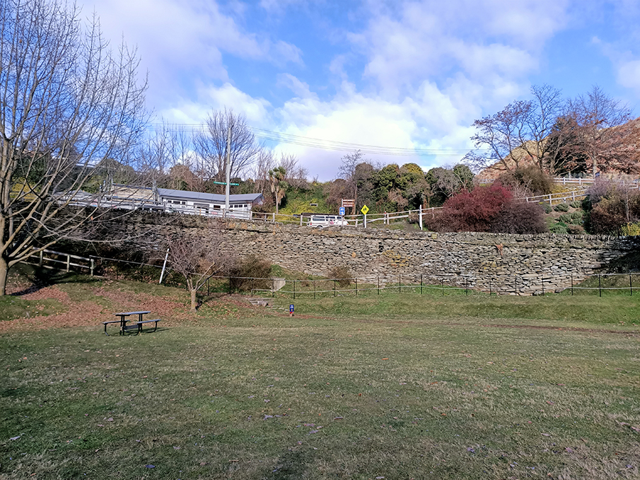
The stone wall that supports the western end of Buckingham Street, Arrowtown, as it descends to the Bush Creek Flat was constructed in 1886 to connect the centre of Arrowtown to the recently completed road to Macetown. It is both a beautiful example of 19th century stacked stone construction, topped by a parapet, and a reminder of the need to cart to and communicate with the goldfield settlements of the mountainous interior. It has been assessed has having aesthetic and historic significance. Te Wai Pounamu has an enduring history of Māori occupation including at Te Haehaenui (the Arrow River) and Kā-muriwai (the Arrowtown Flat). Te Haehaenui was one of the travel routes between the Wanaka and Hāwea to Whakatipu-wai-Māori. Hunting of weka, koreke, tuna, aruhe, kāuru and kōura, supported the communities that were located there. Trade and transport continued throughout early gold mining (including Māori undertaking goldmining themselves) and despite alienation and farming, tangata whenua for the area retain strong connections to the land. The land on which the wall was to be built appears to have been designated as part of Buckingham Street since at least 1867. However, it is unlikely a formed road stood here until much later – photographs taken from the 1870s into the 1880s show the land was at the edge of a precipitous drop down to Bush Creek Flat with no formed access between these two levels. It’s possible that access to the flat could have been made here on foot or horseback, but not by carts. The continuing need for an easy cartage route for supplies at Macetown led to the construction of a dray road up the Arrow to the township in 1884. However, access to the river level for heavy traffic appears to have been problematic.–In September 1885 this led to calls for, ‘a road work to connect Buckingham street [sic] with the Macetown Road’. Tenders were called for in January 1886, with a further call for tenders for the parapet’s construction in May of that year. It is not recorded who provided the successful tender for the construction of the retaining wall; however, the successful tenderer for the parapet is noted as a Peter Henderson. The wall consists of stacked local schist, supporting the Buckingham Street roadbed. At its highest, the roadbed sits about 6 m above the Bush Creek Flat. The wall follows the northern edge of Buckingham Street in roughly three sections as the road curves to the north. Contemporary newspaper articles described the parapet wall as consisting of ‘2ft dry stone walling capped with stones bedded in mortar, making a height of 2ft 9in.’ The wall was originally designed to incorporate drainage channels. The Buckingham Street wall has been in constant use since its construction in 1886. Although the necessity for access to Macetown has waned since the 1880s, the development of Arrowtown as a tourist destination (and particularly the archaeological remains of the Chinese Settlement at Bush Creek) has led to very heavy use of the road at this point. From at least 2006 onwards it has been noted that parts of the structure had been bowing. However, no extensive modification of the structure appears to have been undertaken.
Location
List Entry Information
Overview
Detailed List Entry
Status
Listed
List Entry Status
Historic Place Category 2
Access
Private/No Public Access
List Number
2120
Date Entered
11th November 1983
Date of Effect
11th November 1983
City/District Council
Queenstown-Lakes District
Region
Otago Region
Extent of List Entry
Legal Road (NZ Gazette 2014 p. 1699), Otago Land District
Legal description
Extent includes part of the land described as Legal Road (NZ Gazette 2014 p. 1699), Otago Land District, and the structure known as Stone Wall, thereon. Refer to the extent map tabled at the Heritage List/ Rārangi Kōrero Committee meeting on 6th April 2023
Stay up to date with Heritage this month
