Construction Professional
Biography
F.W. Burwell (1846-1915) is noted for designing many buildings in Invercargill, transforming the centre of the town between 1874 and the mid-1880s. Born in Scotland, Burwell served his articles with the architect John Matthews and immigrated to New Zealand in the late 1860s. By 1873, he had established his practice in Queenstown. He moved to Invercargill the following year. Once established there, he began designing elegant two and three-storey buildings in the Renaissance style. He designed almost all the buildings in Dee Street, including the hospital. 'The Crescent' was another notable Invercargill streetscape created by Burwell. In recognition of his work, he was elected a Fellow of the Royal Institute of British Architects in 1880. The depression in the 1880s saw his commissions decline and he moved to Australia in 1887 where he practised in Melbourne, Perth and then Fremantle. He was particularly successful in the last, as Western Australia was in the middle of a building boom, and a number of his commercial buildings in central Fremantle are now classified by the Australian Heritage Commission. Burwell returned to Melbourne in 1910, and died there five years later. (Jonathan Mane-Wheoki, 'Burwell, Frederick William (1846-1915)' in Jane Thomson (ed.), Southern People: a dictionary of Otago Southland biography, Dunedin, 1998, p. 74.)
Biography
William Grant (d.1884) and Duncan MacKellar (d.1890) were building contractors working in Cromwell in the 1870s and 1880s. The two men were previously timber merchants together in the 1860s.
Duncan MacKellar (variant spelling McKellar) followed gold to Cromwell in 1862. He followed various occupations including dredging, timber rafting, carpentry, bridge building, and journalism and was head master of Cromwell School. He also represented the Kawarau electorate in the Provincial Council, and was at one time Secretary for Goldfields.
William Grant was active as a builder in Cromwell in the 1860s, winning the contract for the Bank of New South Wales there in 1867. Grant died at age 49 in January 1884.
Source: Registration Report for St John's Presbyterian Church (Former), Register No. 2131, Dec 2012.
Construction Details
Description
Tenders called for construction of church
Description
Church completed
Type
Original Construction
Description
Rear extension for Sunday school classes constructed
Description
Kitchen added to the Sunday school extension, used also as a vestry
Description
Former Crown Terrace Schoolhouse moved onto site as Sunday School
Description
Schoolhouse removed back to Cardrona
Construction Materials
Stone, timber, corrugated iron
Historical NarrativeEarly History
Kai Tahu whanui were familiar with the Upper Clutha area. The Mataau/Clutha River was one of the major river systems which enabled exploration and discovery. Many trails were established by tipuna who followed the natural valley systems of the Waitaki, Waihemo, Taieri and the Mataau to the plains and valleys of Central Otago for seasonal food gathering. Along the trails the takata whenua established kaika nohoaka (semi-permanent campsites). These sites were carefully placed to allow maximum use of local resources. The high country mountains, valleys and plains were places of spiritual significance. The site where modern day Cromwell is was known as Wairere.
It was other resources, first pastoralism and then gold that drew European settlers to the Upper Clutha. The history of the town of Cromwell is linked with the history of the discovery and mining of gold in Central Otago. Gold mining began in Central Otago with Gabriel Read’s discovery of gold in Gabriel’s Gully, near present-day Lawrence, in 1861. The following year Hartley and Reilly left this gully and travelled further into Central Otago. They spent the winter prospecting in the now-flooded Cromwell Gorge between present day Clyde and Cromwell, finding enough gold in the area to travel back to Dunedin and lodge 87 pounds with the Gold Receiver.
The 1862 discovery precipitated a rush to the area. Cromwell, at the northern end of the gorge and only a mile or so from Hartley’s claim, was first known as The Junction, for its location on the junction of the Kawarau and Clutha Rivers. The town was surveyed and given its official name in 1863. Cromwell was declared a municipality in 1866.
Cromwell’s first Presbyterian clergyman was the Reverend Benjamin Drake. From the time of Drake’s ministry, Cromwell clergymen also ministered to the Bannockburn congregation. Drake was appointed to the Cromwell Presbyterian Church in 1868 and ordained as a minister in 1875. From 1865 until the church was completed in 1881, services were held in the first school building and then in the stone schoolroom in Sligo Street. Cromwell, then, became a formal charge in 1874. A Session was not formally appointed until 1892 and a management committee in 1898.
A lack of timber meant that most of the town structures were built from stone, as was the case with St John’s Presbyterian Church. A building fund was begun in 1874. Various events including a bazaar at Cromwell, a soiree at Bannockburn as well as a synod grant show the community support for the project. In 1878, the year that Benjamin Drake retired, the first steps towards building a Presbyterian Church were taken with the purchase of a section of land bordering Sligo and Inniscourt streets in the name of the Otago Presbyterian Church Board of Property.
Local historian J.C. Parcell records in July 1879 that tenders were called for the construction of a stone church 50ft by 30ft (15 by 9m) with a bell tower 54ft (16m) high. The bell tower does not seem to have been built. Prominent Invercargill architect F.W. Burwell designed the building. The Church was built by local contractors Grant and MacKellar.
F.W. Burwell (1846-1915) is noted for designing many buildings in Invercargill, which transformed the centre of the town between 1874 and the mid-1880s. By 1873 he was established in practice in Queenstown and moved to Invercargill the following year. In recognition of his work he was elected a Fellow of the Royal Institute of British Architects in 1880. The depression in the 1880s saw his commissions decline and he moved to Australia in 1887 where he practised in Melbourne, Perth and then Fremantle. His other churches include St Paul’s Presbyterian Church (Category 2, Register No. 2517) in Invercargill and St John’s Presbyterian Church (Category 2, Register No. 2119) in Arrowtown.
The Church, bell and furniture cost £1,095. The roof trusses are constructed in the queen-post style, and the ceiling is lined with tongue and groove. The main entrance and lancets on either side are hooded (the opening is recessed into the hood). The first service was held in the church on April 1 1881. The Otago Daily Times wrote ‘the plucky little town has shown in its church building operations a wisdom worthy of all commendation.’ The church occupied a ‘commanding position, and is the first object to strike the tourist.’
In 1905-1910 a minister burning accumulated papers burnt down the church’s stable and sheds. The ladies of the parish funded the rebuilding of the sheds, and the construction of a Sunday School. The Sunday School opened debt free in May 1913. The Sunday school cost £399. In 1934 a kitchen was added to the Sunday School.
In the 1970s the government developed a plan to flood the Clutha Valley in a scheme for power generation. While many of Cromwell’s residents were dismayed by these plans that involved submerging a large part of their town, in 1992 the flooding finally took place. Much of the original town in Melmore Terrace, built close to the banks of the Clutha, disappeared under Lake Dunstan/ Te Wairere, with a new township being constructed on a higher terrace closer to State Highway 8B. St John’s Church, built on a higher terrace above the site of the original town, was not affected by the development of Lake Dunstan, and remains a significant landmark.
In 2003 Cromwell’s Presbyterian community made the decision to build a larger church on a new site and to sell St John’s and the neighbouring manse. St John’s was sold in March 2004.
In 2012 St John’s remains in private ownership.
Physical DescriptionCurrent Description
Setting
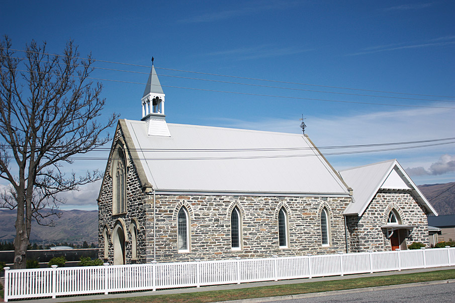
The former St John’s Presbyterian Church is located on a prominent site on the corner of Inniscort and Sligo Streets in the old part of Cromwell. The Church sits in a mature garden setting, amidst lawns and trees. Nearby on Sligo Street is the Catholic Church of the Irish Martyrs (1909). These churches stand as landmarks overlooking Lake Dunstan/ Te Wairere and are visible from across the lake.
Exterior
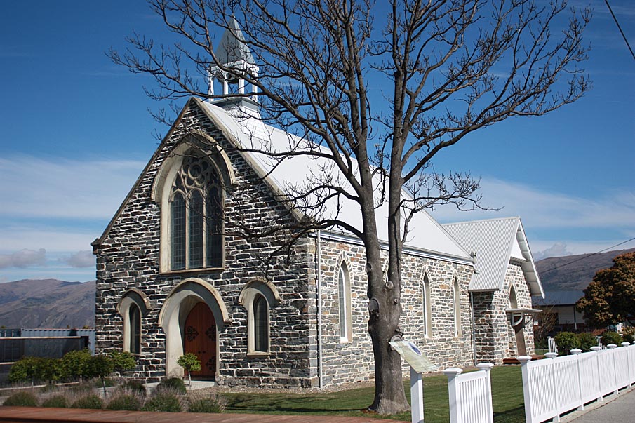
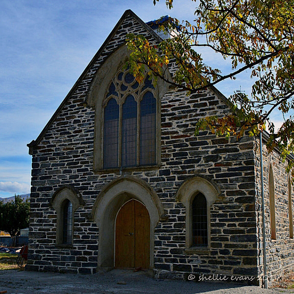
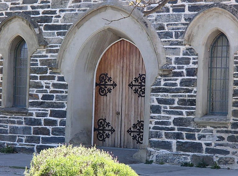
St John’s is built in simple Gothic style. It is a single-gabled church constructed of schist rubble masonry laid to course. The front elevation has a central three-light grouped Lancet window. It has limestone tracery and a shouldered surround on the upper part of the window. Single Lancet windows, also with shouldered surrounds, flank a central arched double door. All three window openings contain leaded glass. The double door is made from tongue and groove timber with elaborate strap hinges.
The side elevations are divided into four equal bays. They are lit by single Lancet window openings. The roof is corrugated iron. There is a belfry mounted on the gable above the main door. There are cast iron ventilation grills at the base of the walls.
The Church Hall, added in 1913, uses the basic form and Gothic style of the church but with a move towards Tudor Revival style. Conservation architect Jackie Gillies writes that this style progression is shown in the overhanging eaves, the projecting timber porch, the window proportions and tracery. The construction is schist rubble brought to course. The openings are pointed arches throughout, with the exception of the round-headed southwest window.
A kitchen was added in 1934. In the 1950s the former Crown Terrace Schoolhouse was moved onto the site to house a Sunday School. It was removed back to Cardrona in the 1990s.
Interior
The interior of the church is divided into two spaces – an entrance lobby and the body of the church itself. These are divided by a timber screen, topped by a choir balcony at mezzanine level reached by a modern spiral staircase.
In the nave of the church the timber truss roof is a combination of hammer beam and tie beam forms, with curved braces. The roof planes between the trusses are clad in tongue and groove timber.
The Church Hall is a single open space with a half-pitched ceiling divided into three bays by arched brackets. Walls are rendered and painted. There is a timber dado rail and skirting. The original timber doors and windows remain.
The later additions are plain and functional. Walls are plastered and painted and the fittings are modern throughout.
ReferenceCompletion Date
12th December 2013
Report Written By
Heather Bauchop
Information Sources
Gilkison, 1978
R. Gilkison, Early Days in Central Otago Whitcoulls, Christchurch, 1978
Kennedy, 1999
N. Kennedy and R. Murray, Early Pioneers in the Cromwell Area 1863-1880, Cromwell & District Historical Society with the assistance of the Cromwell Community Board, Cromwell, 1999
Parcell, 1951
James C. Parcell, 'Heart of the Desert: A History of the Cromwell and Bannockburn Districts of Central Otago', Christchurch, 1951
Paterson, n.d.
R.M. Paterson, 100 Years: The Centennial of the Establishment of the Parish of St. John's, Cromwell. [Cromwell]
Report Written By
A fully referenced registration report is available from the Otago/Southland Office of the NZHPT.
Please note that entry on the New Zealand Heritage List/Rarangi Korero identifies only the heritage values of the property concerned, and should not be construed as advice on the state of the property, or as a comment of its soundness or safety, including in regard to earthquake risk, safety in the event of fire, or insanitary conditions.