

Kāi Tahu ki Otago used all areas of the Taieri Plain as evidenced by the hundreds of mahika kai sites associated with the numerous waterways, lakes and wetlands in the area which was one of the most significant food baskets of the Otago region. An important route, referred to by J. H. Beattie as a ‘Maori track’, passed through the area. In July 1844, the Otago Purchase, negotiated by Frederick Tuckett, was signed at Kōpūtai / Port Chalmers. This agreement alienated a large areas of land around Dunedin in European hands.
Occupation of the Taieri by Pākehā picked up from the 1840s; settlers from this time included the Jaffrey family. This may have been the ‘Jeffreys’ family that are noted as owning the land in 1852. In that same year, this parcel was sold to a William Love. Within 3 months, Love sold the parcel on to James & John Gow. The Gow family would own this parcel for over 100 years. The Gows were originally from Dunkeld, in Perthshire; they sailed to New Zealand on the Agra, landing in 1852. They were living at the site, and calling it “Invermay”, since at least the mid- to late-1850s; a newspaper article of 1856 reports the birth ‘At Invermay, East Taieri’ of a son to ‘Mr John Gow.’
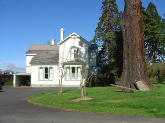
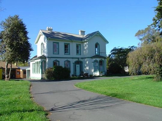
Daphne Lemon notes that their first home was ‘a sod cottage’, later replaced by a ‘sun-dried brick’ residence, situated ‘on the present lawn [while] they watched their third house being built; Lemon indicates that the third house was built in 1862 and is the current building on the property; however, it is likely that this building was constructed in the 1870s; this would make the homestead a particularly early example of domestic construction in this medium. She indicates that the original slate flooring of the kitchen came over with the family in 1852, as part of the ballast of the Agra ‘but has since been removed to the area around the clothes line.’
Subsequent generations of Gows held Invermay and the associated lands until 1956, when it was acquired by the University of Otago; the house was used for accommodation. The use of this site as an agricultural research station had been mooted as early as 1949. The majority of research work has since been undertaken nearby, to the east of the homestead. Until 1970 the homestead was occupied by the Director of the Animal Breeding Station. The majority of the late-20th century buildings on the land were constructed as part of this use; these included the construction of stables for the Animal Breeding Station, later renovations, and extensions to these facilities. There were also upgrades to the residence in 1979. When Lois Galer visited the site, in the late-20th century, she noted that ‘many of the original [interior] fittings remain, like the sculpted plaster roses around the centre lights…the delicately turned balustrade and the old panelled doors’.
In 2013 the Government announced a winding down of operations at the Invermay AgResearch centre, a decision that caused much consternation locally. As of 2020, research still appears to be being undertaken at the Invermay complex, under a subsidiary or associate company of the University of Otago: Disease Research Limited. The current use of the homestead is unknown.
List Entry Information
Status
Listed
List Entry Status
Historic Place Category 1
Access
Private/No Public Access
List Number
2350
Date Entered
27th July 1988
Date of Effect
27th July 1988
City/District Council
Dunedin City
Region
Otago Region
Extent of List Entry
Extent includes part of the land described as Lot 1 DP 6164 (RT OT323/16), Otago Land District and the building known as Invermay, thereon. Refer to the extent map tabled at the Heritage List/ Rārangi Kōrero Committee meeting on 23 March 2022.
Legal description
Lot 1 DP 6164 (RT OT323/16), Otago Land District
Why is this place significant?
Historic Significance
Historical Significance or Value The pioneer who settled this land was John Gow. He came from Dunkeld, Perthshire, with his brother, James and sister and wife in 1852. John and James Gow took up crown grants on about 1275 acres of land on the east Taieri in the 1850s and 1860s. They managed to buy outright a 50 acre section in 1852 from a land speculator for 47 pounds ten shillings and around 1866 the crown grants for many of their sections were approved. The approval of the grant implied that the settler had farmed the land for three to five years and made improvements worth about 100 pounds. (The criteria varied under the different Waste Lands Acts). John Gow built for his family first a sod cottage (where the Reverend Burns visited them in 1852), then a mud brick cottage and finally this substantial home. The Land Registry records show that John Gow was in residence early enough to have built his house in 1862 and the early records of the Taieri Agricultural Society suggest that he was thriving in sheep farming. His estate included what is now the Invermay Research Station farm and the Wingatui race course. The house mow has only 4.2 hectares around it. It was bought by the University of Otago. It is now used as living quarters for staff who manage animal breeding quarters built in the grounds.
Physical Significance
Architectural Significance: A solidly built concrete Victorian house of a wealthy Taieri farmer. If it was built in 1862 it is an earlier poured concrete dwelling than Castlamore and the oldest concrete dwelling in New Zealand. Townscape/Landmark Significance: One of the larger homes on the Taieri with some fine trees around it.
Construction Details
Start Year
1862
Type
Original Construction
Construction Materials
Poured concrete foundations and walls. The roof is covered with slates. It is a large house with five bedrooms upstairs and a billiard room as well as two living rooms and a spacious kitchen downstairs.
Notable Features
The size and age of this early concrete house, its association with a pioneer family.
Date: Older members of the Gow family (Miss Gows of Outram) told Daphne Lemon that the house was built in 1862 which would make it the oldest poured concrete dwelling in New Zealand and older than Judge Chapman's house. Shaw and Farrant state that it was built in the early 1860s. Architectural Description (Style): A very simple two storied one-bay house with slight classical touches, such as arched window heads on the lower floor and pilasters around the windows of the bay. Modifications: The exterior appears to be unmodified and many of the interior fittings such as ceiling roses and the staircase balustrade remain. The brick surrounds to the fireplaces appear to be 1920s vintage. The billiard room seems to have been added at a later date, judging by two painted over windows in the upstairs hall which open into its ceiling cavity.
Date: Older members of the Gow family (Miss Gows of Outram) told Daphne Lemon that the house was built in 1862 which would make it the oldest poured concrete dwelling in New Zealand and older than Judge Chapman's house. Shaw and Farrant state that it was built in the early 1860s. Architectural Description (Style): A very simple two storied one-bay house with slight classical touches, such as arched window heads on the lower floor and pilasters around the windows of the bay. Modifications: The exterior appears to be unmodified and many of the interior fittings such as ceiling roses and the staircase balustrade remain. The brick surrounds to the fireplaces appear to be 1920s vintage. The billiard room seems to have been added at a later date, judging by two painted over windows in the upstairs hall which open into its ceiling cavity.
Historical and Associated Iwi / Hapū / Whānau
Completion Date
20th January 2022
Report Written By
Andrew Winter
Information Sources
Galer, 1981
L. Galer, Houses and Homes, Allied Press, Dunedin, 1981
Lemon, 1970
Daphne Lemon, Taieri Buildings: with drawings by Audrey Bascand, McIndoe Print, Dunedin, 1970
Shaw, 1949
Margaret Shaw and Edgar D. Farrant, The Taieri Plain: Tales of the Years that are Gone, Otago Centennial Historical Publications, Dunedin, 1949
Kirk, 1985
Kirk W.R., Pulse of the Plain – A History of Mosgiel, Mosgiel Borough Council, Dunedin, 1985.
Other Information
A fully referenced copy of the Summary Upgrade report is available at the Southern Area Office of Heritage New Zealand Pouhere Taonga. This historic place was registered under the Historic Places Act 1980. This report includes the text from the original Building Classification Committee report considered by the NZHPT Board at the time of registration. Please note that entry on the New Zealand Heritage List/Rarangi Korero identifies only the heritage values of the property concerned, and should not be construed as advice on the state of the property, or as a comment of its soundness or safety, including in regard to earthquake risk, safety in the event of fire, or insanitary conditions.
Former Usages
General Usage: Research
Specific Usage: Scientific building/ laboratory
Former Usages
General Usage: Research
Specific Usage: Scientific building/ laboratory
Location
Stay up to date with Heritage this month
