

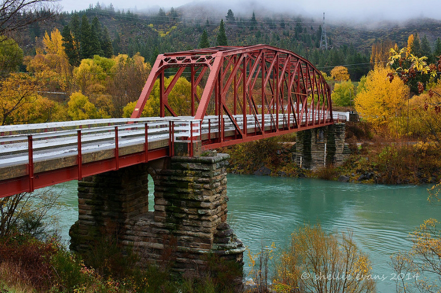
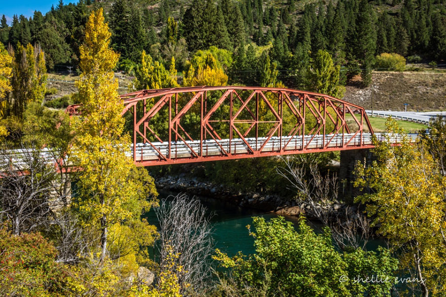
The Earnscleugh Bridge is a single lane 'through truss' road bridge with stone piers and abutments, and a pedestrian walkway on the east side, separate from the carriageway. The piers and abutments date from the first bridge across the Clutha River at Clyde, built in 1874. The bridge was originally a suspension bridge. Floods twice destroyed the suspension structure. The development of infrastructure such as roads and bridges in New Zealand is a major strand of history on a both a local and national level. For communities such as Clyde such bridges were a vital link to the wider world, particularly when the town's history is so bound with the powerful Clutha River running in the gorge below the town. Earnscleugh Bridge was part of the first wave of bridge building in that area of Otago and the piers are a reminder of the work of County Engineer Leslie Duncan Macgeorge who was responsible for a number of bridge designs in Central Otago in the 1870s. The subsequent development as a bridge capable of handling motor vehicles also illustrates the second wave of history of such structures, when they had to be adapted for such use. The engineering of the superstructure from the 1930s illustrates that history of adaptation which was part of the Vincent County programme of the period.
Location
List Entry Information
Overview
Detailed List Entry
Status
Listed
List Entry Status
Historic Place Category 2
Access
Able to Visit
List Number
2370
Date Entered
3rd March 2006
Date of Effect
3rd March 2006
City/District Council
Central Otago District
Region
Otago Region
Extent of List Entry
The registration applies to the whole bridge, including superstructure, piers and wing walls. The bridge is on part legal road known as Fruitgrowers Road over the Clutha River at Clyde, and part legal river (Clutha River).
Legal description
Part legal river, part legal road.
Historic Significance
Historical Significance or Value Earnscleugh Bridge has historical significance. The development of infrastructure such as roads and bridges in New Zealand is a major strand of history on a both a local and national level. For communities such as Clyde such bridges were a vital link to the wider world, particularly when the town's history is so bound with the powerful Clutha River running in the Gorge below the town. Earnscleugh Bridge was part of the first wave of bridge building in that area of Otago and the piers are a reminder of the work of County Engineer Leslie Duncan Macgeorge who was responsible for a number of bridge designs in Central Otago in the 1870s. The subsequent development as a bridge capable of handling motor vehicles also illustrates the second wave of history of such structures, when they had to be adapted for such use. The engineering of the superstructure from the 1930s illustrates that history of adaptation which was part of the Vincent County programme of the period.
Physical Significance
The bridge has technological significance. It illustrates the nineteenth century technologies in its use of the schist piers designed by Leslie Duncan Macgeorge. The stone piers and wing walls are typical of the technology dating from that period, and are also represented in nearby structures, including the Category I piers and towers at Alexandra, and the Daniel Connell bridge at Ophir. The later steel structure has technological significance as an example of a Pennsylvania camelback truss bridge, a variation on the Parker Truss. This type of construction was common in the United States in the 1920s. The Earnscleugh Bridge is a good example of that technology. It is not known how common this type of truss system was in the New Zealand context.
Detail Of Assessed Criteria
(a) The extent to which the place reflects important or representative aspects of New Zealand history The history of the Earnscleugh Bridge reflects the development of the physical infrastructure of inland Otago. The bridging of the Clutha River was a particular issue that many small towns along the river, such as Cromwell, Clyde, Alexandra, Roxburgh and Balclutha faced. The power of the river in flood is evidenced by the destruction of the early superstructure of the bridges along the river. The bridges illustrate the importance of the county engineer's role in facilitating communications through the bridge-building programme. The Earnscleugh Bridge also illustrates the change to motor vehicle transport in the early twentieth century and the effect this change had on infrastructural development. (b) The association of the place with events, persons, or ideas of importance in New Zealand history The Earnscleugh Bridge is associated with Vincent County Engineer Leslie Duncan Macgeorge. Macgeorge is representative of the nineteenth century surveyor come engineer who was a pivotal figure in the development of the provinces. His work is significant in Central Otago. (e) The community association with, or public esteem for, the place The Earnscleugh Bridge piers are held in high esteem by the community. This was demonstrated when the bridge was rebuilt in 1935. It was originally planned to site this new bridge at a different point on the river, but because of "the people's earnest wish to retain the historic piers" this plan was abandoned and the bridge rebuilt on the original site. (g) The technical accomplishment or value, or design of the place The bridge shows technical accomplishment is its original design, as well as the later adaptation for vehicular traffic. The 1870s piers have withstood floods which washed away a number of other structures on the Clutha River in 1878, and subsequently, an indication of the quality of the work that the piers survived. The integration of the 1930s superstructure on the piers, as requested by the local people, is an important aspect of the design, and is also a good example of the engineering technology of the period. (k) The extent to which the place forms part of a wider historical and cultural complex or historical and cultural landscape The Earnscleugh Bridge forms part of the cultural and historic landscape of Clyde and Central Otago. Other historic bridges in the area designed by McGeorge such as the Daniel O'Connell suspension bridge at Ophir and the former suspension bridge at Alexandra, of which only the piers and towers remain, are built with similar schist piers and towers. The towers and piers of the former Alexandra Bridge, and the Daniel O'Connell Bridge are both registered as Category I historic places.
Construction Professional
Biography
Leslie Duncan Macgeorge (1854-1939) was born in Adelaide and trained as a surveyor. He came to New Zealand in the 1870s. In 1876 he transferred to Central Otago. He held the position of County Engineer until 1902, after which he entered private practice in Dunedin and Timaru. He retired to Melbourne, and died there in 1939. Source: Registration Review Report for Alexandra Bridge (Former), Alexandra, Sept 2013.
Name
Macgeorge, Leslie Duncan
Type
Engineer
Biography
English-born Frederick Goodman learnt his trade as a civil engineering contractor working on the four major concrete bridges in Auckland, including the Grafton Bridge and being the foreman of the Mangere Bridge contract, completed in 1915. In 1912-13 he constructed the Orakei sewerage outfall station for Auckland. In 1917 he moved to Gisborne to work on the Mangapoike pumping station. He was responsible for the construction of major structures in Gisborne, including Peel Street Bridge (Record no. 3569), Kaiti Bridge aka Gladstone Road Bridge (Record no. 3534) and the railway bridge (Record no. 3533), plus the middle section of the diversion wall for the harbour in Gisborne. Goodman was also involved in engineering work for the Otago Harbour Board in the early 1930s. He was involved with the construction of the 1935 improvements to the Earnscleugh Bridge in Central Otago (Record no. 2370). Fred Goodman died in 1946 at Napier.
Name
Goodman, Frederick
Type
Builder
Biography
Cyrus John Richard Williams (1862-1942) trained as a civil engineer in Queensland, and in December 1902 was appointed engineer to the Lyttelton Harbour Board, at a salary of £500 per annum for a term of three years. He held the position, along with those of Secretary and Treasurer to the Board from 1912, until his retirement in 1927. Williams re-designed the Lyttelton wharf and was in charge of reclamation works there. He was accorded the rank of Member of the Institute of Civil Engineers in 1902. He was president of New Zealand Society of Civil Engineers (now IPENZ) for a one-year term in 1920-21. He was a member of the Nelson Harbour Board and in 1929 he wrote a paper regarding the opening of a new entrance to Nelson Harbour. Williams was one of the construction professionals who worked on the improvements to the Earnscleugh Bridge, Clyde, Central Otago in 1935 (Record no. 2370). As a renowned marine engineer Williams contributed to reports for the Gisborne, Napier and Waikokopu harbours, sat on a panel investigating the collapse of the Western Wharf in Auckland and on Royal Commissions at Foxton and Timaru.
Name
Williams, Cyrus (1862-1942)
Type
Engineer
Biography
Williamson Construction Company The Christchurch-based Williamson Construction Company was founded by William Henry Williamson (d.1971), the third generation of the Williamson family to be involved in the building trade. Gaining his first building contract when an apprentice carpenter aged 17, Williamson went on to build hydro-electric stations, freezing works at Kaiapoi and throughout the country, as well as hospitals, bridges, hotels and theatres. He was responsible for construction of the iconic Edmonds Factory (1922 - now demolished) which stood in Ferry Road; and the Nurses' Memorial Chapel (1927) in Riccarton Avenue, both in Christchurch. Williamson described the latter, a brick structure with Oamaru stone dressings and open timber roof trusses, as 'the finest building he ever built'. A large recently refitted warehouse (believed to date from the early 1930s) at 137 Montreal Street, Christchurch, originally provided storage and served as a work yard for Williamson Construction which conducted business on the site from 1934. William Williamson's office, a small but grand building with a strong classical façade, still stands next door complete with the company's name in brass lettering. In the late-1930s, rivalry with the Auckland-based Fletcher Construction Company occurred. This was taken to a new level in 1943, when Williamson Construction secured the contract to build an asbestos-cement plant in Christchurch with a bid uncontested by other South Island contractors, spurring Fletcher Construction to re-establish itself in the South Island. Both construction companies survived the Depression and war years. The science block at the University of Canterbury and the South Pacific Hotel in Auckland were among some of Williamson's last major contracts. William Williamson died in Christchurch in December 1971, leaving his son Peter to carry on the business. Williamson Construction finally ceased to exist in the 1980s.
Name
Williamson Construction Company
Type
Builder
Construction Details
Description
Original piers and bridge constructed
Finish Year
1876
Type
Original Construction
Description
Decking and cables washed away in a flood
Finish Year
1878
Type
Demolished - Other
Description
Decking and cables replaced
Finish Year
1881
Type
Modification
Description
Decking and cables replaced with a steel camel back truss, and bridge lengthened (Vickerman and Lancaster)
Finish Year
1935
Type
Modification
Construction Materials
Stone piers and wing walls, steel trusses
Notable Features
The Bridge piers, superstructure and wing walls.
Earnscleugh Bridge crosses the Clutha River just to the south of Clyde in Central Otago, approximately a kilometre below the Clyde Dam. The stone piers date from the first bridge built in 1874. The piers have survived floods which twice washed away the cabling and decking of the original bridge. In 1935 the bridge was lengthened and the suspension structure replaced by a camelback truss. The eye-catching bridge sits amidst the rugged Central Otago hills providing a link between Clyde and nearby Earnscleugh. The history and development of Clyde is intrinsically linked with the history of the discovery and mining of gold in Central Otago. In August 1862 the Dunstan Rush began. Although the town was officially named Clyde in 1864, the area was first known as Dunstan in the 1850s (then part of Moutere Station) and as Hartley's township after Horatio Hartley's discovery of gold nearby. The 1862 discovery precipitated a rush to the area, with the first passenger-carrying coach travelling from Dunedin to Clyde in November of that year. A ragged canvas town quickly sprang up, and by December of that year between six and seven thousand miners and settlers occupied Clyde and the surrounding area. Transport and in particular river crossings soon became important local issues. Only a year after the first discovery of gold many seeking their fortunes, sleeping under canvas on the banks of the Clutha River near Clyde were swept away in a sudden flood and up to 100 men were drowned. A photograph dated c.1862 shows a profile of canvas and wooden buildings along the terrace above the river where the town now stands, and a small collection of wooden structures on the lower beach. These early photographs show the Clutha River running below the banks of the town, a road running down to the water but no bridge yet in place. The area on the west of the river formed part of Earnscleugh Station, and was also extensively mined. Initially two boats, one kept on the west and one on the east bank were used to cross the river. In 1862 the enterprising Donald McPherson purchased two punts and made the road to the riverside, operating a ferry service to connect Clyde with the sheep stations and mining settlements on the west. From the middle of 1863 further punts were added, in particular a fast new boat named The Pioneer that made the crossing in a minute. The high cost of ferrying people and goods across the river led to the decision to build a bridge below the town. In July 1874 at a special meeting the town council decided to raise a loan. A plan of Clyde Bridge Reserve dated 1875 shows the Clutha River, the route usually taken by the punt, the road to the river on the Clyde town side and the reserve with no road marked on the Earnscleugh bank of the river. The bridge designed by Vincent County Council Engineer Leslie Duncan Macgeorge (variously spelt McGeorge, 1854-1939), and built by William Grant, was completed in July 1876 at a cost of £6,500. Plans dated 1874 for the 'suspension bridge over river Clutha at Clyde' give details of the structure with its piers and towers, with the suspension wires running over a capped saddle. It was christened 'Clyde Bridge' with a bottle of champagne by the wife of local storekeeper Benjamin Naylor. The mayor and councillors were driven over in a Cobb and Co coach, watched by a celebrating crowd of 300 people. The toll on the bridge for the final six months of 1876 amounted to £111 5s 6d. Only two years later another natural disaster struck Clyde. The winter of 1878 was long and severe, with heavy snowfalls and frosts, and reports of drifts even 100 feet (c.30m) deep in some ravines. A warm spring with a hot north west wind came quickly in late September, followed by torrential warm rain and a rapid snow melt. The Clutha rose higher than had ever been known and stayed in flood for three weeks, according to Gilkison 'one of the most terrible visitations to Central Otago since its first settlement.' Gilkison described the river 'rolling its way to the ocean, its angry surface strewed with dead horses and cattle, houses, bridges, furniture, timber, and farm stacks.' After the lowlands were submerged, the 'great destruction' of the recently completed bridges began. The new suspension bridge at Clyde at first resisted the torrent, but as the trees and debris accumulated against it the wire ropes gave way and the structure was swept downstream, leaving the stone piers still standing. Again, as Gilkison described it: 'On 29 September, at half-past eleven in the morning, the wreck was seen passing Alexandra, and later on, the remains of the Clyde and Roxburgh bridges, lovingly linked together, passed Balclutha on their way to the sea.' Other bridges at Bannockburn, the Lower Shotover and Rocky Point also succumbed. Thornton, writing in a less romantic vein, points out that as the Clyde bridge was swept away it took with it other downstream structures from Roxburgh, Beaumont and finally Balclutha, unable to withstand the wreckage. With the loss of the bridge, the punt was reinstated and the decision made to rebuild on the same site, using the undamaged piers and the salvaged wires. A tender for £4,949 from Duncan McKellar was accepted, and Vincent Pyke laid the foundation stone in April 1880. Before the work was finished extensions were decided upon, at a further cost of £1,198. The bridge was completed in July 1881. Thornton points out that the caps on the nearby Alexandra Bridge were of cement plaster, perhaps a likely construction detail for the same features on the Clyde Bridge. The decking was timber and the bridge had diagonal wooden railings on either side, perhaps also functioning as bracing. In a view to the west, the raw Central Otago landscape of stacks of new gold tailings is evident. Nearly fifty years later this structure was apparently no longer able to meet the needs of motorised transport and a replacement steel arch suspension bridge was planned. By the 1920s there were several early bridges in the Vincent County Council area required attention, and the Council engaged Wellington-based consulting engineers Vickerman and Lancaster to undertake an extensive programme of new works. The new superstructure and the partially rebuilt piers and abutments of the Clyde Bridge were their designs. The original intention in reconstructing the bridge was to resite it, but this plan was abandoned in the face of the strong public desire to retain the historic piers. Plans for this structure dated 1931 describe the earlier bridge and details the removal of the towers from the piers. The tender was let to St. Bathans builder and contractor Thomas Wilkinson, well known for his work on the Commercial and Dunstan Hotels in Clyde. When Wilkinson died within a few months of starting on the construction, work was suspended, leaving Clyde without a river crossing once again apart from the bridge at Alexandra, ten kilometres away or a cable chair eight kilometres beyond Clyde, used by orchardists for produce. When four men attempted to use the chair the cable collapsed, three of them drowning in the river. Tenders for the bridge were let again to Williams and Winaley for £7,689. The new bridge was completed by the end of 1934 and formally opened in April 1935. The wife of the County Council Chairman, Mrs. Ritchie, cut the ribbon, and ceremonies were followed with a 'splendid banquet in the Council Chamber.' Some time after the opening of the reconstructed bridge the name changed to Earnscleugh Bridge. Today the bridge continues to provide a link between Earnscleugh and Clyde and remains an important feature in the landscape of the region.
The Earnscleugh Bridge is a single lane 'through truss' road bridge with stone piers and abutments, and a pedestrian walkway on the east side, separate from the carriageway. The piers and abutments date from the first bridge across the Clutha River at Clyde, built in 1874. The bridge was originally a suspension bridge. Floods twice destroyed the suspension structure. There are two stone piers at the river's edge. The piers are constructed in shaped rusticated stone, with a central arch. The wing walls are stacked stone with vertical stone capping. The original towers above the decking height have been removed and concrete extension piles continue on both the west and east sides of the bridge. Thornton describes the main span, 61.4 metres long, as a Pennsylvania camelback truss, with varying slopes on the top chord, two other spans of 13.4 metres and two of 6.7 metres. A camelback truss is a variant of the Parker Truss, where the polygonal top chord has exactly five slopes. The concrete deck is 3.6 metres wide. The wooden cross railings have been replaced with horizontal metal railings. Thornton considers this an attractive structure in its red livery, with local schist masonry in the piers and abutments. The American-design Parker truss is a modified Pratt truss, creating a top chord which did not stay parallel with the bottom chord. This created a lighter structure, capable of longer span, without losing strength. In places such as the United States the Camelback Parker Truss was in common use in the 1920s. The piers and towers built for the first bridge were a vernacular feature of many Central Otago bridges designed by Vincent County engineer Leslie Duncan Macgeorge. Towers designed by Macgeorge and/or built by Grant and McKellar similar to those at Clyde can be seen at the Shakey Bridge, Alexandra, the Lake Hawea outlet bridge, and Daniel O'Connell Bridge (Category I), Ophir. Architect and engineer Geoffrey Thornton considers that the most spectacular of these, with imposing arched schist piers and towers, was the Alexandra Suspension Bridge over the Clutha River (Category I).
Completion Date
6th June 2006
Report Written By
Heather Bauchop
Information Sources
Archives New Zealand (Dun)
Archives New Zealand (Dunedin)
Gilkison, 1978
R. Gilkison, Early Days in Central Otago Whitcoulls, Christchurch, 1978
Lawn, 1977
C.A. Lawn, 'The Pioneer Land Surveyors of New Zealand' unpublished manuscript, New Zealand Institute of Surveyors, 1977
McCraw, 2003
J. McCraw, Gold on the Dunstan, Square One Press, Dunedin, 2003
Moore, 1953 (reprint 1978)
C. Moore, The Dunstan, Whitcombe & Tombs, Dunedin, (First published 1953, Capper Press reprint 1978)
Parcell, 1976
J. T. Parcell, Heart of the Desert: A History of the Cromwell and Bannockburn Districts of Central Otago, Christchurch, Whitcoulls, 1976
Thornton, 2001
Geoffrey Thornton, Bridging the Gap, Early Bridges in New Zealand 1830-1939, Auckland, 2001
Veitch, 1976
B. Veitch, Clyde on the Dunstan, John McIndoe, Dunedin, 1976
Report Written By
A fully referenced registration report is available from the NZHPT Otago/Southland Area office Please note that entry on the New Zealand Heritage List/Rarangi Korero identifies only the heritage values of the property concerned, and should not be construed as advice on the state of the property, or as a comment of its soundness or safety, including in regard to earthquake risk, safety in the event of fire, or insanitary conditions.
Current Usages
Uses: Transport
Specific Usage: Bridge/ Viaduct
Former Usages
General Usage:: Transport
Specific Usage: Bridge/ Viaduct
Stay up to date with Heritage this month
