

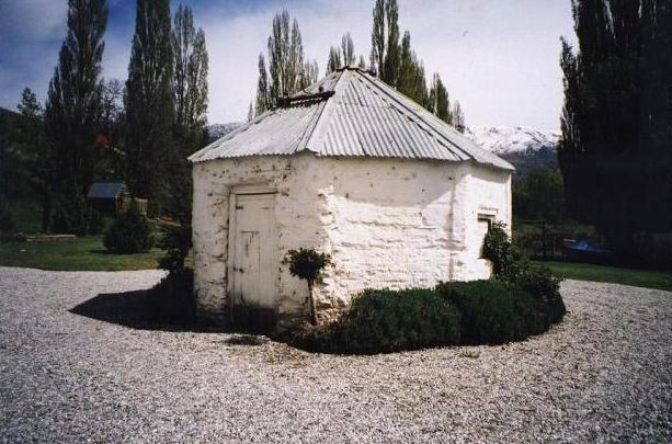
Little is known about John Werner, the original owner of the property, whose name remains attached to this small unusual structure he built in the 1870s. On an 1886 land title for ten acres John Werner is named as a miner . Werner is known to have kept a herd of dairy cows on the property and to have held a seat on the Vincent County Council ; but he appears to have left the district by the end of the nineteenth century . In 1907 Werner sold the block to Harry Wood and since this time the land has changed hands many times. In 1998 then owner Alan Martin subdivided the property. In 2000 he entered into a heritage covenant with the NZHPT . The dairy now sits on a section of land of 8398 square metres and is owned by Douglas Saunders, who purchased it in November 2003 . The property is rented out to tenants.
List Entry Information
Status
Listed
List Entry Status
Historic Place Category 2
Access
Private/No Public Access
List Number
2392
Date Entered
14th April 2005
Date of Effect
14th April 2005
City/District Council
Central Otago District
Region
Otago Region
Extent of List Entry
Registration includes part of the land in Certificate of Title OT19A/390 and the Werner dairy, and its fixtures and fittings thereon. The registration includes only the land on which the dairy sits and not the larger section - Grid Reference 117614 (Higham, 1976)
Legal description
Lot 1 DP 27246 (RT OT19A/390), Otago Land District
Status
Listed
List Entry Status
Historic Place Category 2
Access
Private/No Public Access
List Number
2392
Date Entered
14th April 2005
Date of Effect
14th April 2005
City/District Council
Central Otago District
Region
Otago Region
Extent of List Entry
Registration includes part of the land in Certificate of Title OT19A/390 and the Werner dairy, and its fixtures and fittings thereon. The registration includes only the land on which the dairy sits and not the larger section - Grid Reference 117614 (Higham, 1976)
Legal description
Lot 1 DP 27246 (RT OT19A/390), Otago Land District
Why is this place significant?
Historic Significance
Historical Significance or Value The Werner dairy has significant architectural, historical value. Its historical value lies in its age as the dairy is estimated to have been built in the 1870s, and its use as a dairy, for processing milk into cheese and butter on the small Werner farm, which is representative of the history of farming practices on small holdings in Otago.
Physical Significance
It is a small vernacular structure unusual in its octagonal shape that stands out in the Lowburn landscape. In 1976, Higham et al noted that this dairy was said to be one of only three such octagonal structures in New Zealand.
Why is this place Category 1 / Category 2?
Detail Of Assessed Criteria
This unusual octagonal shaped building was constructed by the first European settler on this block of land, and so it is associated with the early European settlement of the Lowburn district, and integrally associated with the history of the area. Constructed from locally available schist and cob, this small vernacular structure is well known and held in esteem in the local community. The dairy was used daily during early methods of farming for processing milk products, and this kind of structure has been long obsolete. In this respect the dairy provides knowledge of New Zealand's history. One of only three such identified structures , it is also a rare building. The Werner dairy is one of a series of vernacular farm structures still standing that date from the first years of European land holdings in Central Otago. It stands in close proximity to the Partridge farm buildings, and is approximately the same age. These structures are associated with small holdings and are built in a similar style and from schist and limestone mortar. They are the extant remnants of a former historical landscape. The Kai Tahu ki Otago Natural Resource Management Plan does not record any sites in the area of the Werner dairy. A findspot, where an adze was located, is identified as iwi site number G41-C7 (NZAA site number G41/546), in the general Lowburn area.
Why is this place significant?
Historic Significance
Historical Significance or Value The Werner dairy has significant architectural, historical value. Its historical value lies in its age as the dairy is estimated to have been built in the 1870s, and its use as a dairy, for processing milk into cheese and butter on the small Werner farm, which is representative of the history of farming practices on small holdings in Otago.
Physical Significance
It is a small vernacular structure unusual in its octagonal shape that stands out in the Lowburn landscape. In 1976, Higham et al noted that this dairy was said to be one of only three such octagonal structures in New Zealand.
Why is this place Category 1 / Category 2?
Detail Of Assessed Criteria
This unusual octagonal shaped building was constructed by the first European settler on this block of land, and so it is associated with the early European settlement of the Lowburn district, and integrally associated with the history of the area. Constructed from locally available schist and cob, this small vernacular structure is well known and held in esteem in the local community. The dairy was used daily during early methods of farming for processing milk products, and this kind of structure has been long obsolete. In this respect the dairy provides knowledge of New Zealand's history. One of only three such identified structures , it is also a rare building. The Werner dairy is one of a series of vernacular farm structures still standing that date from the first years of European land holdings in Central Otago. It stands in close proximity to the Partridge farm buildings, and is approximately the same age. These structures are associated with small holdings and are built in a similar style and from schist and limestone mortar. They are the extant remnants of a former historical landscape. The Kai Tahu ki Otago Natural Resource Management Plan does not record any sites in the area of the Werner dairy. A findspot, where an adze was located, is identified as iwi site number G41-C7 (NZAA site number G41/546), in the general Lowburn area.
Construction Professional
Name
Werner, John
Type
Builder
Biography
No biography is currently available for this construction professional
Construction Materials
Cob mix with stone (schist) incorporated, with a white plaster wash.
Construction Professional
Name
Werner, John
Type
Builder
Biography
No biography is currently available for this construction professional
Construction Materials
Cob mix with stone (schist) incorporated, with a white plaster wash.
This octagonal shaped building is illustrated in Thornton. There is a central post from which the rafters spring to support the corrugated iron roof. Each octagonal side measures approximately 1.83 metres (6ft) in width and the height of the building is 2.26 metres. The windows have been removed and replaced with shutters. The wooden flooring is of Baltic pine .
This octagonal shaped building is illustrated in Thornton. There is a central post from which the rafters spring to support the corrugated iron roof. Each octagonal side measures approximately 1.83 metres (6ft) in width and the height of the building is 2.26 metres. The windows have been removed and replaced with shutters. The wooden flooring is of Baltic pine .
Historical and Associated Iwi / Hapū / Whānau
Information Sources
Angus, 1977
J. Angus, One Hundred Years of Vincent County Council, Vincent County Council, Dunedin, 1977
Higham, 1976
C. Higham, G. Mason, and S. Moore, 'Upper Clutha Valley: An Archaeological Survey' Dunedin: Department of Anthropology, University of Otago, 1976
Stephenson, 2004
Janet Stephenson, Heather Bauchop and Peter Petchey, 'Bannockburn Heritage Landscape Study', Department of Conservation, Science and Research Unit, Wellington 2004
Thornton, 1983
G. Thornton, Historic Buildings of New Zealand Auckland: Methuen, 1983
Thornton, 1986
Geoffrey Thornton, The New Zealand Heritage of Farm Buildings, Auckland, 1986
Other Information
A fully referenced registration report is available from the NZHPT Otago/Southland Area office Listed as site number G41/392 on the New Zealand Archaeological Association's site recording scheme. An adjacent building, the former Werner farmhouse according to Higham et al, is listed as site number G41/393. Please note that entry on the New Zealand Heritage List/Rarangi Korero identifies only the heritage values of the property concerned, and should not be construed as advice on the state of the property, or as a comment of its soundness or safety, including in regard to earthquake risk, safety in the event of fire, or insanitary conditions.
Historical and Associated Iwi / Hapū / Whānau
Information Sources
Angus, 1977
J. Angus, One Hundred Years of Vincent County Council, Vincent County Council, Dunedin, 1977
Higham, 1976
C. Higham, G. Mason, and S. Moore, 'Upper Clutha Valley: An Archaeological Survey' Dunedin: Department of Anthropology, University of Otago, 1976
Stephenson, 2004
Janet Stephenson, Heather Bauchop and Peter Petchey, 'Bannockburn Heritage Landscape Study', Department of Conservation, Science and Research Unit, Wellington 2004
Thornton, 1983
G. Thornton, Historic Buildings of New Zealand Auckland: Methuen, 1983
Thornton, 1986
Geoffrey Thornton, The New Zealand Heritage of Farm Buildings, Auckland, 1986
Other Information
A fully referenced registration report is available from the NZHPT Otago/Southland Area office Listed as site number G41/392 on the New Zealand Archaeological Association's site recording scheme. An adjacent building, the former Werner farmhouse according to Higham et al, is listed as site number G41/393. Please note that entry on the New Zealand Heritage List/Rarangi Korero identifies only the heritage values of the property concerned, and should not be construed as advice on the state of the property, or as a comment of its soundness or safety, including in regard to earthquake risk, safety in the event of fire, or insanitary conditions.
Current Usages
Uses: Vacant
Specific Usage: Vacant
Former Usages
General Usage: Agriculture
Specific Usage: Dairy/ buttery/cheese house
Current Usages
Uses: Vacant
Specific Usage: Vacant
Former Usages
General Usage: Agriculture
Specific Usage: Dairy/ buttery/cheese house
Location
Sign up to hear more
Get the latest heritage news, features and events delivered
straight to your inbox.
