Earliest inhabitants:
Traces of human occupation in Murihiku can be dated back to around 1250-1300. The first Polynesian arrivals in New Zealand soon found their way early to the eastern and southern South Island, where moa were found in large numbers. By the time of European settlement, however, moa were extinct and Maori were clustered on the coast. Key coastal settlements were at Shag Point, Waikouaiti, and Huriawa (Karitane's original name), which was a stronghold of the Ngāi Tahu chief Te Wera. They identified themselves as Ngāi Tahu, and also with that tribe's predecessors, Ngāti Māmoe and Waitaha.
Circular depressions revealing the presence of Maori umu can be seen inland in the Waihemo area. Although Maori life was strongly established on the coast, this was part of a well used route to inland Otago. Central Otago was not only a rich source of moa but prized greenstone was found around Lake Wakatipu. Excavations reveal many major moa hunting sites were inland, although most of the sites were occupied only temporarily. Indeed it has been suggested that from the mid 1830s there were no permanent Maori settlements in inland Otago.
European Settlement:
Adequate communication and transport routes were one of the many problems faced by the new settlers. New Zealand's countryside was littered with mountains, steep hills, dense bush and many a fast flowing river. Added to this problem were the limited resources in terms of money and skilled tradesmen. Drowning was the most common cause of death among settlers in the earliest decades. Often the cause was attempting to cross rivers, especially when in flood. Even coaches were often overturned, sometimes resulting in fatalities. With the discovery of gold in Otago, impetus grew to provide better transportation routes to the interior. As the gold rush intensified, so did the population and investment. At the peak of the rush the goldfields population was estimated at 24,000.
The first travellers from Dunedin to Central Otago in the early 1860s faced a difficult trip across the old Dunstan Road. The early miners named it 'The Mountain Road' and it followed an almost direct line from Dunedin to the Dunstan - a distance of 175 kilometres. It crossed four major mountain ranges - Lammermoor, Rock and Pillar, Rough Ridge and Raggedy Ranges. Horse-drawn drays took two or three weeks to complete the round trip from Dunedin to Dunstan and back. This was reduced to three days each way when scheduled coach services began from Dunedin in November 1862. Around 1864 a safer, more reliable alternative to the old Dunstan Road developed. The second route was known as the 'Pigroot', so named for the district's fame as a rooting ground for some of Captain Cook's pigs. Coaches, including the famous Cobb & Co, travelled the coast road from Dunedin to Palmerston and then followed the Pigroot, now State Highway 85, over the Maniototo Plains and onto the Dunstan. Although it was the longer route by 50 kilometres, it travelled across plains, over lower hills, and avoided major river crossings.
The demand for improved infrastructure continued to grow with the population. The provincial councils took on the responsibility of providing adequate transport routes, which could be very inadequate indeed. One traveller recounts:
The coach, which was very much smaller than the one which ran to Palmerston, was rolled along at a rattling pace over the level road to Dunback by a team of five sturdy horses. After fording the Shag River, the road became worse, and long before reaching Waihemo it began to partake of the nature of a sludge channel, though which horses floundered in their attempt to obtain solid footing. In fact there was no such thing as a made road.
Bridge Construction:
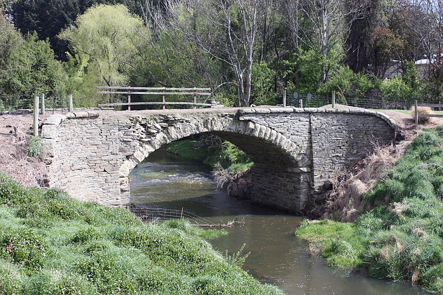
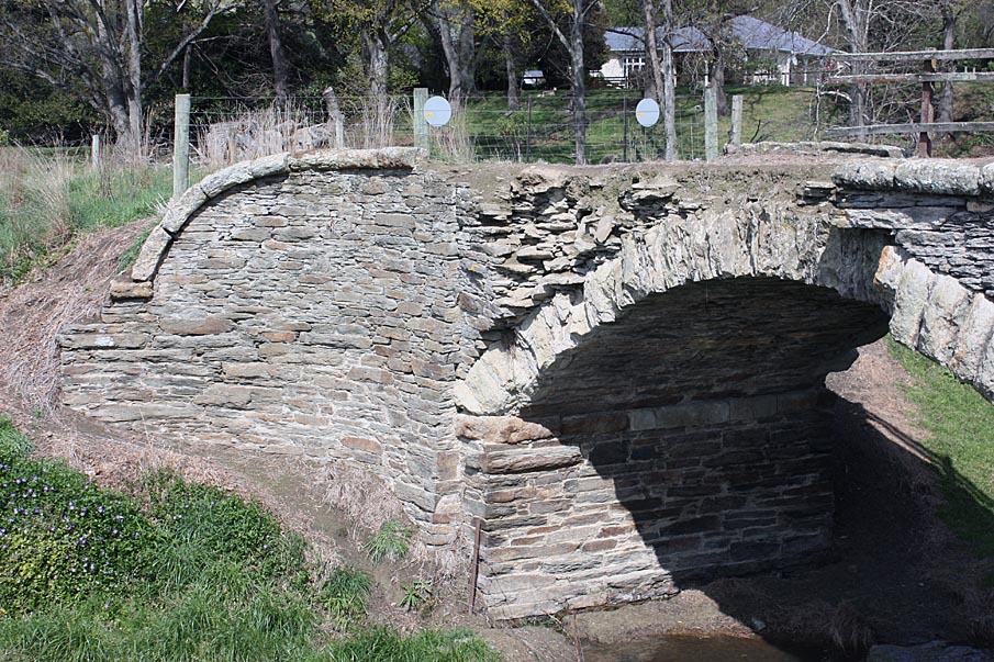
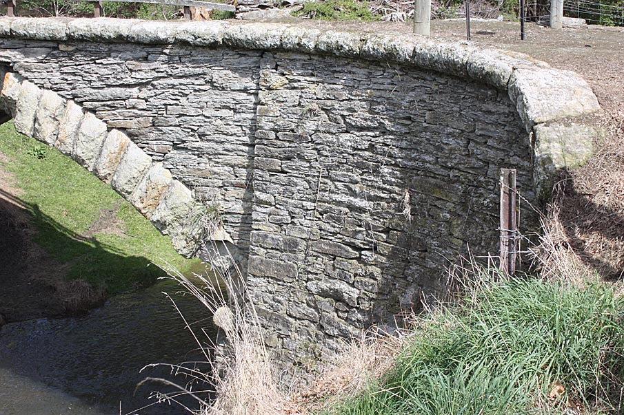
The Pigroot crosses a number of waterways, including McCormicks Creek which crosses the Pigroot between Palmerston and Dunback. A few years after the development of this alternative route to the goldfields, a bridge was built over McCormicks Creek to speed the advance of coaches. Unusually for the period, this bridge was erected in stone. Indeed it is one of New Zealand's earliest examples of stone arch bridge building.
Considering the many thousands of bridges that have been built in this country, stone arch structures do not figure prominently. The reasons can be attributed to a lack of suitable stone in some areas, a shortage of masons, the limitations of the relatively short spans available and the higher cost, and the much greater availability of timber throughout New Zealand at the time many of our bridges were built.
Timber was usually the preferred choice. Many areas lacked stone suitable for bridge building, which limited the number of stone bridges built throughout the country. The short supply of masons was an additional hindrance. Stone bridges were also believed to cost more than timber. By the late 1860s, however, contemporary opinion was turning against timber. In his report of 1868 to the Otago Provincial Council, John Turnbull Thomson, the Engineer of Roads and Works, recommended that on the issue of 'Bridge construction, I may remark that I would strongly recommend the Government to introduce iron or stone in to all the essentials, as the native timber has proved inferior in quality for permanence'. Also significant to the construction of the bridge was the local availability of schist stone. Accordingly, the decision was made to construct a stone bridge. Geoffrey Thornton's discussion of bridges indicates how unusual this decision was. His research into early bridges in New Zealand indicates that McCormicks Creek Bridge may be among the first ten stone arch bridges ever built in the country.
Late in 1868 a contract was drawn up between James Macandrew, Superintendent of the Province of Otago and architects Farquhar McIver and Co. In December of that year, Farquhar McIver (c.1834-1901) produced a design for a graceful arched stone bridge over McCormicks Creek. A report to the Otago Provincial Council, dated 31 March 1869, noted that the 'bridges completed or commenced since the 31st March, 1868, are as follows:.. (4.)
Stone. McCormick's Creek, Shag Valley...Completed.' The bridge, then, was presumably built in the months following the release of the design on 29 December 1868 and 31 March 1869 when the report to the Provincial Council was written.
Cost:
The cost of erecting the bridge is unavailable, but the total budget is likely to have amounted to less than the cost of a erecting a timber bridge. A discussion concerning the use of timber versus stone in bridge building noted that the 'liability of the native timbers to rapid decay would justify this [i.e. the use of stone or iron] even at an increased present cost, but there are one or two bridges above enumerated have been constructed of stone at a less cost than could have been done of timber. I refer more particularly to those in the Shag Valley, where timber is not easily obtained, and stone suitable for masonry purposes is to be had in the neighbourhood.'
Appellation:
The name of the bridge is a matter of some confusion. The Waihemo County Council simply referred to the bridge as the 'stone bridge' in the Dunback Riding. The title 'McCormicks Creek Bridge' appears on Farquhar McIver's plan of the bridge in 1868. This appellation is used subsequently on survey plans and certificates of title.
McCormicks Creek may have been named after an early settler in the district. Thomas McCormack (c.1827-1908), his wife Catherine (c.1843-1883), and the first four of their eight children arrived at Port Chalmers in 1852 on board the Robert Henderson. After a brief residence in Dunedin, the family removed to Dunback. McCormack reportedly took over 'The Grange' property, Run 109, which included the creek. As Run 109 was owned first by Charles Hopkinson (1856-1859) and subsequently by Captain Thomas Fraser (1859-1862), it is likely that McCormack was simply a farm hand, or perhaps a manager. McCormack worked the property until 1861. The family then left for Hampden where they remained for 47 years. Perhaps, then, the creek was named for this early settler, albeit with a change in spelling.
The latter years:
In 1890 the Waihemo County Council considered improving the approach to the bridge by cutting about 5 chains of siding on the west side and a deep rock cutting on the east side of about 4.5 chains. The estimated cost was about £80 and consideration was deferred. In June 1892 it was reported to the Council that the road had been widened near the bridge.
Although the bridge was first known as McCormicks Creek Bridge, at some point it became known locally as 'Bowker's Bridge'. This name appears in documents from 1957 when there were plans for a proposed realignment of the road and a new bridge was scheduled for construction in 1958/1959. According to these documents the name of the old stone bridge was 'Bowker's Bridge' and the new bridge to be sited on the realigned road would also be called Bowker's Bridge. The Lions Club of Palmerston, Transit New Zealand and the Palmerston Gateway to Gold group placed signage at the old stone bridge also referring to it as Bowker's Bridge.
It seems this name change may have been affected by the occupation of the Bowker family in the early decades of the twentieth century. By the 1880s most of the land to the left of the bridge was owned by Frances Dillon Bell and later his son Alfred Dillon Bell. Charles Bowker (1842-1915) also began purchasing land in the area and in October 1913, Thomas Burgess Bowker (1882-1931), Charles' son, purchased from the Bells the land to the left of the bridge. Charles Bowker had arrived on the Zealandia in 1863 in Lyttelton and became a land broker in Timaru. He helped finance Thomas' purchase of the land and following Charles' death in 1915, the mortgage was transferred to Thomas' brothers, George and James, and stepmother Harriet. Following Thomas' death in 1931, the land was transferred to his son Thomas Layton Bowker (1911-1942). Thomas Layton Bowker joined the armed forces at the outbreak of World War II in 1939 and was killed on 23 October 1942 in France. In 1944 the land passed out of Bowker family hands. Yet their occupation of the land surrounding the bridge no doubt contributed to it becoming known locally as Bowker's Bridge.
Road realignment and a new bridge was proposed c.1957. The old bridge was one way and inadequate for increased traffic demands. Following a delay in construction, the new bridge, known as Bowker's Bridge, was completed in 1962.
McCormicks Creek Bridge is now the last of the original arched stone bridges on the old coach road to Central Otago and as such represents a distinctive example of the region's transport history.