Five Rivers Station Complex (homestead, woolshed, stables and farm cottage dating from the early 1860s to the 1880s) sits at the end of Selbie Road, around seven kilometres to the north west of the small Southland settlement of Five Rivers. The buildings are set on flat land, with the area bounded by the Eyre Mountains to the north. Cromel Stream runs to the west (one of the water courses which give Five Rivers its name). Five Rivers has architectural and technological importance. Five Rivers Homestead is architecturally significant as an example of a substantial early run homestead, which has been developed to meet the requirements of the occupants. The original modest 1860s homestead was extended on a grand scale in the late 1870s to include large and imposing living spaces. The design is for a functional rather than decorative residence. The homestead has technological importance as an example of an early brick homestead with bricks burnt on site. Five Rivers reflects the history of the development of pastoralism and agriculture from the middle of the nineteenth century into the twentieth century. The initial pastoral run taken up by the land speculators, and merchant capitalists reflects the broad pattern of land development on a large scale which occurred in inland areas of Otago and Southland. That history of developing a pastoral enterprise in an isolated area is one represented throughout the country, but is one that is an important aspect of New Zealand's history given the significance of the primary industries in the development of the nation. In later years its subsequent subdivision is also a relatively typical of the fate of large pastoral concerns in the twentieth century, and it had an effect on the development of the surrounding areas, opening up land for closer settlement. Five Rivers Station Complex is associated with Otago whaler and businessman Johnny Jones, who also owned at a similar time Shag Valley Station in inland Otago. Jones was a controversial and highly influential figure in the development of Otago, and his wider role in Southland is indicated by his ownership of Five Rivers early in its development. Subsequent owner Charles Wentworth, although not resident in New Zealand, was a similarly contentious figure, involved in the early land dealings with iwi leaders which are a significant episode in the history of colonization in the South Island. Captain John Ellis and the Ellis family more generally also played an important role in the development of pastoralism in Southland, owning at least ten pastoral stations in the area and contributing much to the successful establishment of farming in the deep south.
Location
List Entry Information
Overview
Detailed List Entry
Status
Listed
List Entry Status
Historic Place Category 1
Access
Private/No Public Access
List Number
2547
Date Entered
11th November 1983
Date of Effect
11th November 1983
City/District Council
Southland District
Region
Southland Region
Extent of List Entry
The registration includes part of the land in certificate of title SL12/B/729, the buildings (homestead, woolshed, cottage and stables), and their fixtures and fittings thereon. The extent of registration is part of Lot 4 DP 13851. The boundary follows Selbie Road on the east, skirts around the homestead on the north. On the west boundary the registration follows the fenceline along the edge of the tree planting at the edge of Cromel Stream. The boundary then connects with the road line for Selbie Road. See Plan in Appendix 2 of the registration report.
Legal description
Lot 4 DP 13851 (RT SL12B/729), Southland Land District
Location Description
Note the spelling of Selbie Road is variable. On Landonline and NZ Post's address and post code finder it is spelt Selbie; on NZMS map series topographical maps and Quickmap it is spelt Selby.
Historic Significance
Historical Significance or Value Five Rivers Station has outstanding historical significance. It was the first inland Southland pastoral station to be established, and was associated with figures who were of importance to the development of Southland, in particular whaler, businessman and pastoralist Johnny Jones, Australian statesman and runholder William Charles Wentworth, and pastoralist John Ellis who owned ten pastoral properties in the region.
Physical Significance
Five Rivers has architectural and technological importance. Five Rivers Homestead is architecturally significant as an example of a substantial early run homestead, which has been developed to meet the requirements of the occupants. The original modest 1860s homestead was extended on a grand scale in the late 1870s to include large and imposing living spaces. The design is for a functional rather than decorative residence. The homestead has technological importance as an example of an early brick homestead with bricks burnt on site.
Detail Of Assessed Criteria
(a) The extent to which the place reflects important or representative aspects of New Zealand history Five Rivers reflects the history of the development of pastoralism and agriculture from the middle of the nineteenth century into the twentieth century. The initial pastoral run taken up by the land speculators, and merchant capitalists reflects the broad pattern of land development on a large scale which occurred in inland areas of Otago and Southland. That history of developing a pastoral enterprise in an isolated area is one represented throughout the country, but is one that is an important aspect of New Zealand's history given the significance of the primary industries in the development of the nation. The difficulties experienced through the economic impact of the depression of the 1880s combined with the rabbit plague is also a significant and represent aspect of the history of pastoralism in the South. In later years its subsequent subdivision is also a relatively typical of the fate of large pastoral concerns in the twentieth century, and it had an effect on the development of the surrounding areas, opening up land for closer settlement. (b) The association of the place with events, persons, or ideas of importance in New Zealand history Five Rivers Station Complex is associated with several individuals of special importance to the history of Southland. The property was owned by Otago whaler and businessman Johnny Jones, who also owned at a similar time Shag Valley Station in inland Otago. Jones was a controversial and highly influential figure in the development of Otago, and his wider role in Southland is indicated by his ownership of Five Rivers early in its development. Subsequent owner William Charles Wentworth, although not resident in New Zealand, was a similarly contentious figure, involved in the early land dealings with iwi leaders which are a significant episode in the history of colonization in the South Island. Captain John Ellis and the Ellis family more generally also played an important role in the development of pastoralism in Southland, owning at least ten pastoral stations in the area and contributing much to the successful establishment of farming in the deep south. (e) The community association with, or public esteem for, the place Five Rivers is held in some esteem locally. The current owners of Five Rivers Station have opened their house to visitors and inform visitors of the history of the house and the wider Five Rivers area. The house is included on the heritage trail of Southland, with a plaque and an accompanying brochure explaining its importance to the region. The homestead, woolshed, cottage and stables are included on the Southland District Council District Plan. (i) The importance of identifying historic places known to date from early periods of New Zealand settlement Five Rivers is the earliest inland homestead known to survive in Southland, dating from early 1860s. This is a comparatively early date of settlement for this area, linking to other places such as Ringway Ridges (Category I) which also dates from the early 1860s. Summary of Significance The Five Rivers Station Complex is worthy of category I registration because of its outstanding significance as an early inland Southland pastoral station, and is associated with individuals who had particular importance to the development of pastoralism and agriculture in Southland Province.
Construction Details
Description
Homestead and Woolshed
Period
1860s
Type
Original Construction
Description
Addition to the homestead
Start Year
1879
Type
Addition
Description
Cottage
Period
1880s
Type
Original Construction
Description
Stables
Period
1920s
Type
Original Construction
Construction Materials
Woolshed Corrugated galvanized iron with beech saplings in the interior. Cottage Two-roomed brick cottage used as accommodation for station workers, timber lean-to additions. Homestead Triple brick without cavity. Brick interior walls. Concrete foundations (also described as rock), Baltic pine floors.
What became known as the Five Rivers area was on a well-travelled route to the inland greenstone collection areas for Maori, as well as the nearby resource-rich lakes Te Anau, Manapouri and Wakatipu. There are accounts of inter-tribal conflicts in the vicinity, particular close to what is now Lowther, between Kaweriri and Tutemakohu and their people. A plaque commemorates this conflict. Surveyor John Turnbull Thompson (responsible for the European names in the area recalling streams in his homeland of Northumberland) reported favourably on the potential of the area for farming possibilities, creating a rush for land in the late 1850s. The Five Rivers Run (Run 190), known later as Punjab, was taken by Arthur Hogue, an Invercargill-based Australian land speculator, in September 1857. The run is “very flat and would be about 15 miles long by about six in width.” It was bounded on the east by the Cromel Stream and on the south and west by the Oreti River. Hogue sold the run to whaler Johnny Jones (1808/9-1869) in 1859. There are disputing accounts about the origins of the homestead. One source states that the first part of the homestead was built for Johnny Jones c.1861, possibly by Robert Cupples (d.1911). Local historian G.A. Hamilton writes that the homestead was built as manager's residence during the ownership of Charles Wentworth. Both possibilities put the construction date in the early 1860s. The house was one of the first in Southland to be constructed of burnt brick. The bricks were presumably burnt in clamp kiln from clay dug on the property. Brick making was an industry developed early particularly in the main centres (for example architect Jeremy Salmond states that burnt bricks were used in small scale residential construction in Motueka in 1844). The usual method was to dig and temper the clay, either by digging it over or by having animals trampling it underfoot. The clay was then put into moulds, turned out and air dried. The bricks were stacked (known as a clamp) covered with brush packed in between the layers, the whole clamp covered and then fired. The fire was moved around the clamp, but firing tended to be uneven, and some bricks were comparatively soft. The 1860s section of the Five Rivers Homestead is two-storied with six rooms. Downstairs included three bedrooms with lounge and kitchen; upstairs included a maid's room, a bedroom, and a school room. The Baltic Pine used on the floors was apparently used as ballast on Jones' whaling ships. The schoolroom was used by a succession of owners for education until the public school was opened in 1911. The woolshed was also built in the 1860s. It seems to be generally understood that the first part of the homestead was built prior to 1863. Beattie writes that an obituary of Robert Cupples states that he went to Five Rivers in the mid-1860s where he milled timber for house-building, a period, Beattie suggests, when a number of runholders were upgrading their houses and woolsheds. In 1861 Jones sold the run to New South Wales lawyer, politician and runholder William Charles Wentworth (1792-1872). Wentworth was a land speculator, and as one local writer describes “was not over-scrupulous at times at to how he acquired it.” Wentworth and Johnny Jones were signatories with Ngai Tahu leader Karetai (?-1860) and seven other southern leaders, of a paper which purported to convey to them the whole of the South Island and Stewart Island, a transaction that was later disallowed. Wentworth, who never apparently resided at the station, appointed his relative Henry Hill as manager (and on the double doors in the lounge there is incised 'H.Hill 1-3-64' (See image in Appendix 3 of the Review Report). Sheep returns for the following year show that it was stocked with 2,000 sheep. Hill returned to Australia to manage Wentworth's Burrabogie Station in New South Wales in 1864. In 1864 Devon-born John Ellis (1809-1873) took over the 33,000 acre run. John Ellis rose from clerk to merchant investor, land speculator and politician, in a career roaming from India to South Australia and New Zealand, and back to England. He was a significant shareholder in the Bank of Otago, and came to its rescue on paying its £60,000 debt, and so securing rights to select 80,000 acres of Crown land in Southland. Five Rivers and Merrivale estates were acquired as a result of this deal. The Ellis family were major runholders, owning a further 10 runs in New Zealand, and extensive properties in Australia. John Ellis died in 1873, with T.C. Ellis supervising the run for the Trustees after John's death. In 1873 T.C. Ellis and his brother Chalcones C. Ellis purchased Five Rivers from the Trustees. Phillip A. Vyner was manager until 1896. During his management the homestead was extended. In the period 1875-1885, when Phillip Vyner was manager for the Ellis', the homestead was extended with an additional seven rooms: upstairs a balcony and three bedrooms, and a lead floor in the bathroom; downstairs, three bedrooms. The Ellis enterprises were said to be responsible for more progress in the early days of Southland than any other family. They spent thousands of pounds in fencing, grain growing, and in general improvement of properties, employed large numbers of men improving the land, and imported improved breeds of stock. The two-roomed brick cottage was built from bricks left over from the construction of the second section of the homestead. In 1880 the stock numbers at Five Rivers reached their peak. In that year 225,000 were shorn at Five Rivers woolshed, and the station was 33,000 acres. The Five Rivers Station struggled in the 1880s with the economic downturn, combined with the devastating rabbit plague, hitting the property hard. In 1896 the property was taken back by the trustees of John Ellis's Estate, but Thomas Ellis was kept on as manager until 1911. Historian Alistair Hamilton writes that the Ellis family had 'had a huge influence on the rapid progress of farming' in the Southland Province. In 1910 a syndicate of Canterbury men purchased the run for closer settlement. The property was subdivided and sold in twelve lots. A survey plan dating from around the time of the subdivision (DP 1666) records the buildings present on the homestead block 'which included the house, (wool)shed, stable, men's quarters and other unidentified structures.' Block 4 with the homestead and 7642 acres adjoining, along with the leasehold of another 7050 acres were taken over by A.R. Ward, and in 1916 by the Drummond brothers in partnership, with Peter, wife Selina and family moving into the homestead, hiring a train to bring all their farm equipment and belongings to their new home. In 1947 the land partnership was dissolved and the land split into smaller blocks held among family members, with Peter and Selina living in the homestead until the late 1940s. The family was also involved in setting up Drummond Industries which imported Dutra tractors from Hungary, a locally notable company. The service areas of the house have been modernized by the current owners, and some of the upstairs portion of the 1860s wing of the house has been relined. The majority of the house is largely unaltered. The current owner indicates that the woolshed was previously considerably larger, and that before they owned the property it was reduced in size. It was previously a twenty four blade shearer stand shed, and is now three. Enough iron was removed from the length of the shed to reline the walls. The stables were converted to a workshop probably in the 1950s, and the stalls were removed. Originally they probably had stalls for 6-8 draught horses. Members of the Drummond family continue to live in Five Rivers Homestead in 2007.
Description Five Rivers Station Complex sits at the end of Selbie Road, around seven kilometres to the north west of the small Southland settlement of Five Rivers. The buildings are set on flat land, with the area bounded by the Eyre Mountains to the north. Cromel Stream runs to the west (one of the water courses which give Five Rivers its name). Woolshed 
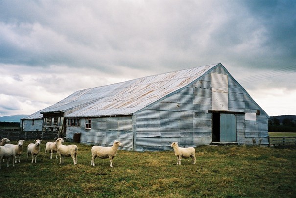
Approaching the complex from the south along Selbie Road, the woolshed is the first building on the west side of the road. It is a long single-storied corrugated iron structure. The woolshed is 115ft (35m) long and 47ft (14.3m) wide. The shed has a gambrel roof on the southern end, and a gable at the northern. The southern elevation has a single door and two small windows. The east elevation, facing Selbie Road, has a door on the southern end. A small timber portion (with five windows and three chutes) sits in the central portion of the east elevation, with a slightly raised roof. There are a set of four small six-light timber framed windows, with a larger single window next to the set. The north elevation has a one sliding door at ground level. The west elevation has four very small four-light windows sitting just under the roof line. The interior is divided into working spaces and pens. The framing is timber, some pit sawn. The building has been braced to strengthen the structure after it racked. Stables The stables sit to c.60m north of the woolshed. This is also a single storey structure, partly clad in timber, partly with corrugated iron. The current owner reports that the stable was kitset, and brought by his father from Canterbury c.1920s, no structural investigation has completed to confirm this date, and there is a stable noted on the 1912 survey plan (see Appendix 4). The structure is U-shaped. The southern wing of the U is clad in corrugated iron on the south elevation and timber on the east and north portions. It has a hipped roof. The timber cladding on the north and east portions have decorative cross bracing. There are several doors on the east elevation. There are two two-light double-hung sash windows in this elevation. The north east wing of the U is clad in corrugated iron and has a single gable, with no hip at the end. This looks to be a more modern structure. Farm Cottage The farm cottage sits to the west of the stables. It is a simple square plan brick cottage with a hipped roof. The main (south) elevation has a central (but off centre) door, flanked by two double hung sash windows. The door and windows have flat arches above. Timber lean-to additions, in several stages, have been added to the north and west elevations. The lean-to additions are in poor condition. There are no windows on the west elevation.
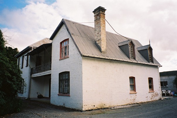
 Homestead The homestead is constructed of brick (now painted white), and has evolved in at least two stages. The first portion was the northern wing. It is a two-storey structure, originally L-shaped in plan. It has a steeply-pitched single-gabled roof and two steeply-pitched dog house dormers on the north elevation, and a single dormer on the west elevation. One of the dormers has a finial on the gable. The dormers have paired five-light casement windows. On the ground floor of the north elevation there are two double hung sash windows. A single chimney projects from the northern side of the roof. The principle east elevation has a covered verandah on both the ground and first floor. The windows at the gable end are multi-pane casement windows, while those opening onto the verandah are double hung sash windows. French doors open onto the verandah. The roof line has been altered at the eastern end, and is asymmetrical, with the original gable line evident at the back (west), and in the brick work on the east elevation. The second stage of construction saw the substantial two-storey south wing. This portion of the homestead is rectangular in plan with a hipped roof, with dentils below. The south and east elevations have single double hung sash windows on the first floor. The ground floor on the east elevation has a triple opening double-hung sash window. The south elevation has a projecting bay window, and two single double-hung sash windows. The west elevation has a single double-hung sash window on both the ground and first floors. The window openings have been altered on the northern side of this elevation. The roof has been extended to meet that of the of the original portion of the house. There has also been a single storey addition to the western elevation. Interior There were three main rooms on each floor of the northern wing of the homestead. Access to the first floor is up a narrow timber stair. On the first floor a partition wall has been removed. The upstairs rooms have steeply pitched ceilings, lined with tongue and groove boards. French casement doors open onto the verandah. The central part of the northern wing has a living room on the ground floor, and the old school room above. The school room has a sloped ceiling, and has the original fire surround in place. A living room door has the words “H Hill March 1st 1864” scratched into the glass. The large additional wing has large interior spaces. The hallway has its original wallpaper, and architraves. What is now the large formal dining room, originally housed a billiard table, as evidenced by the stone insets into the floor which supported the table legs. There is a remnant of the original mural work on the southern wall of the room. The other rooms in this wing are largely used as storage, with some original fire places in situ, and evidence of original wallpaper and other decoration. Comparative Analysis Five Rivers Homestead is one of the first station homesteads to have been built in inland Southland, and is unusual because of its brick construction. Built in two stages, the original house for Charles Wentworth's or Johnny Jones' manager prior to 1863, and then a later wing added in 1879. It originally had a large collection of outbuildings, of which remain are an 1860s woolshed, a cottage dating from the early 1880s and a woolshed. Brick farm buildings are comparatively rare because of their relative isolation from commercial brick works, bricks in isolated areas tended to be burnt on site. Geoffrey Thornton mentions that Te Waimate station had bricks burnt for chimneys in 1860, and that the homesteads of Mt Peel (Record Number 318, category I) and Glens of Tekoa (Record Number 1746, category II), were brick and dated from the mid-1860s. At Homebush there is a collection of farm buildings of brick, including a homestead, but they were commercially burnt. In Otago the former stables at Telford (Category II, Record Number 5199) are brick; in Southland the substantial Marairua Homestead and Stables are also brick (Reference Number 2550 and 3269, currently being assessed). In Southland's architectural history it is one of the earliest and most outstanding farm homesteads. It is associated with men who figured largely in the history of the South Island Johnny Jones and William Charles Wentworth, and also the Ellis family, particularly John Ellis, who played a large role in the development of pastoralism and farming in Southland, and who owned 10 stations in the district, as well as having wider and important interests in Australia. These associations are of special significance, comparable in standing to the other Category I farm homesteads in Southland. Its interior is significant, some of it little altered. Category I farm homesteads include Waimahaka (Record Number 381, constructed 1929 in Georgian style), Fairlight Station Homestead (Record Number 380, a simple plainly detailed Georgian style timber residence constructed 1869 for Captain John Howell who was associated with the early settlement of Southland), and Ringway Ridges Homestead (Record Number 383, a small Gothic style homestead probably constructed from the 1860s onwards and associated with John Henry Menzies). Marairua Homestead is another outstanding brick homestead in Southland, currently under investigation by the NZHPT; it also dates from the 1860s, but has been restored in grand style. Edendale Homestead (Reference number 2544, constructed in 1883 as the manager's house for the New Zealand and Australian Land Company, and associated with the development of the early dairy factory development in New Zealand) is currently being considered for registration as a Category I historic place. Wantwood (with its homestead, farm office, men's quarters and woolshed), the house dating from 1886 is also being considered for Category I registration. Waikaia Plains Homestead (Record Number 3270, Category II), associated with pioneering European explorers and pastoralists, the McKellar Brothers (Peter, John and David), is a smaller but no less impressive stone homestead dating from 1870. It is registered as a Category II historic place. This house was designed by David McKellar who had studied both architecture and surveying, and is among the earliest of the grand runholder houses in inland Southland. This house has been modified, in particular the two distinctive steeply pointed Gothic gable dormer windows have been replaced with a series of pent dormers, and the veranda has also been altered. The external appearance is now more of a bungalow style. The associated buildings at Five Rivers are significant. The substantial woolshed, constructed from pit sawn timber, clad in corrugated iron is an excellent example of its type and remains in use. Possibly dating from the mid-1860s, it is similar to a woolshed at Manapouri Station, also in Southland, also thought to date from the 1860s. The Manapouri Station woolshed (not registered with the NZHPT) is also clad in corrugated iron, and has a remarkably similar form - being a gable at one end, a gambrel roof at the other and a long low dormer on one of the side elevations. The stables have been much altered with a mix of the original timber structure, and later additions with corrugated iron cladding. The cottage is representative of the modest family accommodation many rural families lived in Southland in the mid-nineteenth century.
Historical and Associated Iwi / Hapu / Whanau
Iwi
Ngai Tahu
Completion Date
4th April 2007
Report Written By
Heather Bauchop
Information Sources
Beattie, 1979
JH Beattie, The Southern Runs, Gore Historical Society, Invercargill, 1979
Dictionary of Australian Biography
Dictionary of New Zealand Biography
Hamilton, 1995
Alastair Hamilton, Where Five Rivers Run: A History of the Five Rivers Area, Five Rivers History Committee, Five Rivers, 1995
Hamilton, 1951 (1971)
G.A. Hamilton, History of Northern Southland, The Southland Times Company Ltd. Invercargill, 1971 (first published 1951)
Salmond, 1986
Jeremy Salmond, Old New Zealand Houses 1800-1940, Auckland, 1986, Reed Methuen
Thornton, 1986
Geoffrey Thornton, The New Zealand Heritage of Farm Buildings, Auckland, 1986
Report Written By
A fully referenced review report is available from the NZHPT Otago/Southland Area Office Please note that entry on the New Zealand Heritage List/Rarangi Korero identifies only the heritage values of the property concerned, and should not be construed as advice on the state of the property, or as a comment of its soundness or safety, including in regard to earthquake risk, safety in the event of fire, or insanitary conditions.
Current Usages
Uses: Accommodation
Specific Usage: House
Former Usages
General Usage:: Accommodation
Specific Usage: House