

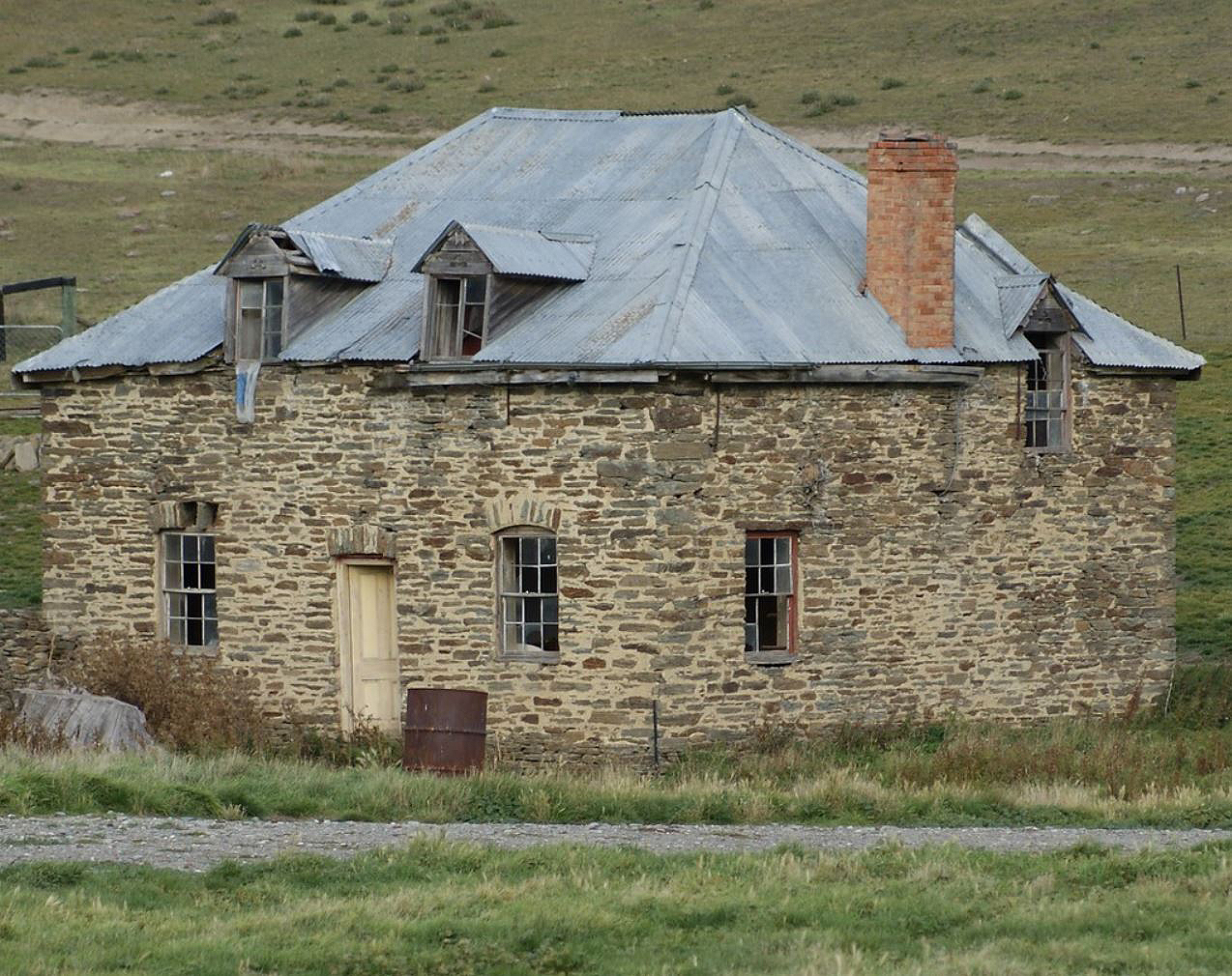
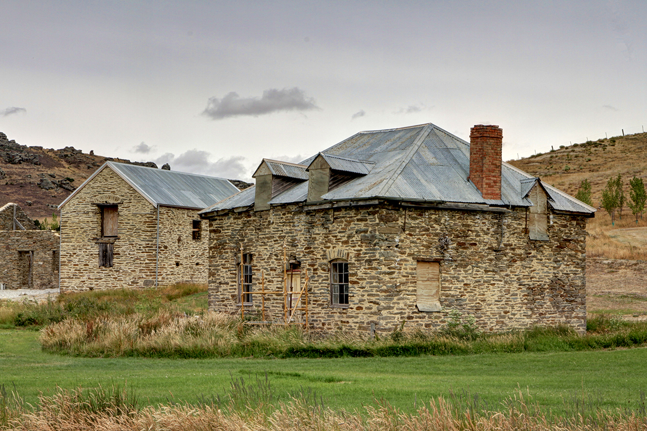
Butler's Farm, an important grouping of a stone farmstead and outbuildings, is set amidst the outstanding landscape of Fruitlands district of Central Otago (originally known as Bald Hill Flat). Established in the early 1870s, the Farm was associated in the twentieth century with the orcharding firm after which the Fruitlands area is named. The area then known as Bald Hill Flat became a centre of gold mining activity in 1862 when miners discovered gold in streams running from the Old Man Range. Local historian John McCraw considers that the first settlers at Bald Hill Flat were John White, Aberdonian Robert Leslie (1819-1880) and Irish-born John McDonough, who had been in the Bald Hill Flat district since at least 1866. John McDonough seems to have built the house (and probably the outbuildings), that are now part of what is locally known as Butler's Farm, in the middle of 1873 as a newspaper report of May of that year describes gold being found when the foundations were sunk. With Leslie and White, he ran a dairy farming operation. Dairy farming was in its infancy and there were few farms which focused on dairying. McDonough, Leslie and White's farm was considered a model of its type. McDonough, White and Leslie dissolved their partnership in 1878. Their property at Bald Hill Flat was advertised for sale in April 1878. The advertisement describes the buildings on the farm: a 4-roomed dwelling house, barn (2 storey, 40 x 20), 5-stall stable, Cart-shed, Milking shed 45 x 18, stockyard, Dairy, Fowl-house 'all substantially built of stone and lime, and fitted up with every convenience.' John Butler purchased the farm in June 1878, and the property became known as Butler's Farm. Antrim County-born Irishman John Butler (1843-1910) had been a land owner in the Bald Hill area since the end of the 1860s, expanding his cropping operations and his land holdings. He was also a prominent member of the local community and on the Vincent County Council for 23 years. The third phase of operations at Butler's Farm was orcharding, and this gave the farm a prominent place in local stories and gave the wider district its name: Fruitlands. On his retirement Butler had approached agents Park, Reynolds Ltd about selling his farm. Eardley Reynolds, one of the principals of the firm, aware of the development of the expansion of stone fruit orchards in the Alexandra district, put together a scheme for subdividing Butler's farm into sections of an appropriate size for fruit growing, known as the Fruitland's Estate. Fruit tree planting was begun in May 1915: 150 acres were planted in fruit trees: 30,000 trees were planted 18 ft (5.4m) apart. By 1921 the planting programme was complete, and it was hoped that 50,000 cases of apples would be produced annually. The optimism was ill-placed. The Company was not able to harvest one single full crop of apples from their Fruitlands Estate. Late frosts ruined the fruiting buds, giving poor harvests. Severe winters in 1926 and 1927 dashed any surviving hopes and the Company was liquidated in August 1928. Most blocks were bought by farmers who set about ripping out most of the fruit trees. Butler's Farm was bought by local run holder and the late John Butler's son-in-law James McCambridge, who rented out the property. One tenant in the 1930s was the prominent journalist Frederick Walter Gascoyne Miller (1904-1996) who was a Depression era gold miner during the 1930s. He immortalised those experiences in his 1949 book There was Gold in the River. The Butler farm buildings are on State Highway 8 in Fruitlands. Butler's Farm is set in pasture land surrounded by the outstanding landscape marked by barren hills with rocky outcrops. Constructed of local stone the farm makes a special contribution to this landscape, and is a noted feature for travellers passing through the district. At the time the farm buildings were built, Bald Hill Flat was the focus of a developing community and there are ruins of various stone and sod buildings in the area. The outbuildings include a barn, stable, cow byre, cart shed, dairy and henhouse. The surrounding plantings are of willow and poplars with remnant fruit tree plantings to the north east of the homestead. Butler's Farm has aesthetic, archaeological, architectural, historical, and technological significance. Its outstanding setting and place in the landscape makes it a special local landmark. Butler's Farm forms part of a network of farmsteads representing the partition of the great pastoral runs and provides insight into the developing pattern of farms in the later nineteenth century. It has special historical significance in its position at the core of the Otago Central Fruitlands Company which gives its name to the area, and providing an insight into a significant element of local history.
Location
List Entry Information
Overview
Detailed List Entry
Status
Listed
List Entry Status
Historic Place Category 1
Access
Private/No Public Access
List Number
3240
Date Entered
2nd February 2009
Date of Effect
2nd February 2009
City/District Council
Central Otago District
Region
Otago Region
Extent of List Entry
Extent includes part of the land described as Lot 1 DP 409481 (RT 434724), Otago Land District and the buildings and structures known as Butler's Farm and their fittings and fixtures, including the house, barn, yard, all outbuildings including those described as a stable, cow-byre and cart-shed, and the associated remnant fruit tree plantings thereon.
Legal description
Lot 1 DP 409481 (RT 434724), Otago Land District
Historic Significance
Historical Significance or Value Butler's Farm has special historical significance representing the history and change in agricultural practices in Central Otago from the 1870s into the first three decades of the twentieth century. The farm, probably built for John McDonough and his business partners as a dairy farm in the early years of the 1870s, was first run as a dairying concern, and then, from 1878 until 1910 as a cropping farm by John Butler. In the 1910s and 1920s the farm was used as a base for the Otago Central Fruitlands Ltd Company which gave its name to the wider district, and the failure of which is part of local folklore. The associated documentary evidence currently being catalogued at the house adds to the value of the Butler's Farm to the local history of the area.
Physical Significance
Aesthetic Significance or Value: Butler's Farm has outstanding aesthetic significance. The stone buildings set amidst the rugged magnificent landscape of this part of Central Otago make a strong visual impression. Their visibility from the State Highway makes them a significant local landmark for residents and travellers. They form an attractive group in this setting. In addition to the landscape setting the stone construction and the design of the buildings, and the homestead in particular have special aesthetic significance. Archaeological Significance or Value: Butler's Farm has archaeological significance. The farmstead has been continually occupied since the 1870s. There is potential for archaeological methods to reveal information from rubbish pits, as well as through documenting changes and development of the structures of the farm, and linking these to the wider changes in the farming and orcharding in this part of Central Otago. The group of the buildings, including the house, express the development of the increasing scale of the farm, the farm operations, and the domestic arrangements to support the farm operation. Study of the buildings has the potential to reveal the nature of these changes, and in turn to provide insight in the workings of a nineteenth century farm. Architectural Significance or Value: Architecturally this collection of buildings is a good example of a farm steading based on Scottish/English farm building types transposed to a New Zealand setting. Hailed at the time of building as a model dairy farm it is a significant example of its architectural type. It illustrates the stonemason's skill and the relationship of form to function in both through its design and layout. Technological Significance or Value: Butler's Farm has technological significance through its illustration of stone building techniques in the nineteenth century, and also through its illustration of the technologies associated with farming during the later nineteenth century. Further analysis of the buildings, to be completed as part of the preparation of a conservation plan for the buildings will add to this knowledge.
Detail Of Assessed Criteria
(a) The extent to which the place reflects important or representative aspects of New Zealand history: Butler's Farm is associated with the development of dairying and cropping in the early 1870s, a significant element in the history of Central Otago. Farms such as that run by McDonough, White and Leslie were the first established after the break up of the large pastoral runs in Central Otago, and represent the first buildings associated with the development of agriculture in this area. The experience of the Otago Central Fruitlands Company, trying to establish orcharding in this harsh environment, is also an important part of the history of the area. Butler's Farm was the centre of the Company's now famous failure, with the story part of local mythology, and the operation giving its name to the wider locality. Orcharding is a vital story to the Central Otago region, and one that is only now being recognised for its significance. (b) The association of the place with events, persons, or ideas of importance in New Zealand history: Butler's Farm is remembered for its association with John Butler, a prominent member of the Fruitlands community and a well known local body politician, serving on the Vincent County Council for twenty three years. Butler's Farm is also associated with the Otago Central Fruitland's Company which gave its name to the locality. The Otago Central Fruitlands Company's failure is of special significance and one that is still recalled as a memorable event. Butler's Farm was the centre of this operation and holds a special place in that history. Butler's Farm is associated with Frederick W.G. Miller's experiences as a Depression miner in the 1930s. Miller's experience, fictionalised in There was Gold in the River, is a poignant recollection of this period, which tends to be passed over in many accounts of local history. Miller is a significant figure in the history of journalism in New Zealand, being the longest serving journalist in the country. (c) The potential of the place to provide knowledge of New Zealand history: Butler's Farm, both in its layout of the farmstead, its place in the wider farm landscape, and in Fruitlands as a whole has the potential to provide insight into the developing farm practices in the nineteenth and early twentieth centuries. The placing of early farmsteads was influenced by the position of early roads relative to land boundaries, the availability of year round water supply, and the amount and lie of arable land. Butler's Farm forms part of a network of farmsteads representing the partition of the great pastoral runs and provides insight into the developing pattern of farms in the later nineteenth century. The pattern is for the land to be divided into smaller blocks with the associated homesteads and outbuildings constructed to house the new settlers. Butler's Farm is among the earliest of these 'break out' farmsteads, dating from the early 1870s, and associated with the first permanent settlers in what is now Fruitlands. Along with other special buildings, such as Mitchell's Cottage, it illustrates the development of closer settlement in this part of Central Otago. (g) The technical accomplishment or value, or design of the place Butler's Farm shows technical accomplishment in its design and use of materials. Their placement in the landscape also shows sensitivity to material and form. (k) The extent to which the place forms part of a wider historical and cultural complex or historical and cultural landscape: Butler's Farm is a significant element in the wider historical landscape of Fruitlands. Fruitlands is notable for its rugged scenery matched with the remnants of historical activity in the area, including gold mining remains, and those related to pastoralism and farming in the area. There are a number of picturesque stone buildings set within this landscape, of which Butler's Farm, along with Mitchell's Cottage are among the most notable. Summary of Significance or Values: This place was assessed against, and found it to qualify under the following criteria: a, b, c, g, k. Conclusion: It is considered that this place qualifies as a Category I historic place. Butler's Farm is worthy of Category I registration because of its outstanding setting in the rugged Fruitland's landscape, and its special association with the Central Otago Fruitlands Company and its famous failure which has made Fruitlands a landmark location.
Construction Details
Description
John McDonough's House (and possibly the outbuildings) constructed
Period
By 1873
Type
Original Construction
Description
House may have been altered by Butler
Period
1880s (circa)
Type
Modification
Description
Electricity connected
Period
1940s (circa)
Type
Modification
Construction Materials
All the buildings are constructed of stone. The homestead originally had a shingle roof (these are no longer in situ), the farm buildings corrugated iron roofs. Timber window joinery.
Maori were long familiar with the Clutha Valley in the Roxburgh area. There are a number of recorded archaeological sites in the Roxburgh Gorge area, with an early site at Obelisk Creek, and the possibility of transient camp sites down the Roxburgh Gorge. The first European to travel to the area, pastoralist and explorer Nathanael Chalmers (1830-1910), was guided by Kaikoura and Reko of Tuturau down the Clutha to the coast in 1853. By the end of the 1850s pastoralists had taken up land and sheep farming was becoming established in Central Otago. Discovery of gold in the Dunstan region in 1863 transformed the Roxburgh area as it was en route to the goldfields. Packers' camps and accommodation houses sprang up to cater for the transient mining population. From the 1860s Bald Hill Flat was a centre of gold mining activity. In 1862 miners moved to prospect in the streams running from the Old Man Range, when gold was discovered on Coal Creek (according to local historian John McCraw, it is more likely that it was found on Obelisk Creek ), resulting in a rush at the southern end of the area then known Speargrass Flat. According to historian James Herries Beattie (1881-1972), this is the area renamed 'Bald Hill Flat' by the proprietor of the Cape Broom Hotel, John Rymill Kemp in 1866. Mining eventually focused on the more productive area of the Obelisk Creek flood plains, where the creek crosses Bald Hill Flat. A few settlers who had arrived as miners first began to occupy Bald Hill Flat from the mid 1860s. At the time, this area was part of the vast Teviot Run. Miners had the right to occupy a residential area of one acre but no right to freehold occupation. Following a petition to the Provincial Government, 2,046 acres (828 hectares) was surveyed off the Teviot Run in 1869 and subdivided into 51 sections ranging from 17 to 50 acres. Settlers applied for agricultural leases before the Proclamation was gazetted in February 1870. By 1870, land in the vicinity of Bald Hill Flat was under cultivation. The Otago Witness reports that the opening of the land under the Agricultural Lease system had seen a 'large number of holdings' already taken up. The names of White, Leslie and McDonough appear on adjoining sections at Bald Hill Flat: sections five, seven and eight. McCraw considers that these three were probably the first settlers at Bald Hill Flat. John White, Aberdonian Robert Leslie (1819-1880) and Irish-born John McDonough had been in the Bald Hill Flat district since at least 1866, and they appear on the electoral roll in local electorates from 1866 until the mid 1870s. An 1873 article in the Tuapeka Times indicates that Leslie and McDonough had lived 'on the Flat' since 'Hartley and Riley's rush on the Molyneux', making them two of the earliest residents. McCraw records that the three men made butter for sale in Alexandra, and grew potatoes and other market garden produce. After the subdivision of the pastoral run they each acquired leasehold land at Bald Hill Flat, and after the required three years, freeholded the 533 acres. John McDonough seems to have built a house on his property in the middle of 1873; a newspaper report of May of that year describes gold being found when the foundations were sunk. McCraw reports that information from descendants suggests that a Mr White was the builder, and considers that this may have been one of the White brothers, cousins of the Mitchell brothers who built Mitchell's cottage, and who came from the Shetland Islands and would have had experience working in stone, rather than Mr John White, one of the owners. This supposition has not been confirmed. The placing of early farmsteads was influenced by the position of early roads relative to land boundaries, the availability of year-round water supply, and the amount and lie of arable land. Butler's Farm forms part of a network of farmsteads in the area that reflect the partitioning of the great pastoral runs and provide insight into the developing pattern of farms in the later nineteenth century. In 1873 a growing conflict of interest in the Bald Hill Flat community between farming settlers and miners came to a head. Miners wanted to continue mining land within the subdivided sections, and wanted to build a sludge channel over a mile long to section 27, in the middle of the Flat. Farmers, entitled to freehold their leases after three years of occupancy, were anxious to do so, and to prevent mining from taking place on their productive sections. A meeting was held at the Cape Broom hotel in August of 1873 to look at the issue, which polarised between the two groups. Following further public meetings an inquiry was held. This resulted in the richest auriferous flood plain of Obelisk Creek being declared a Mining Reserve. It was surveyed off in 1874 and licences issued from 1876. By 1876 cultivation was well established at Speargrass and Bald Hill Flats. The Tuapeka Times records that the area was 'under crop', and 'some very large paddocks are laid down exclusively in grasses, presumably for pasturage purposes.' The correspondent considered that 'that class of farming' was 'very much neglected' to the detriment of the public who could only get a poor grade of meat fed on mountain tussocks rather than well conditioned stock. Dairy farming was also developing, but there were few farms which focused on dairying. The correspondent writes: 'Dairy farms, pure and simple, again I notice are few and far between' but those that exist, if the generally substantial appearance of the homesteads are any criterion, I should imagine, pay well. The best one of this class is that of Messrs White, McDonough, and Co., on Speargrass Flat, whose homestead is a pattern for others to be guided by. The whole of their buildings - including a large two-storey dwelling-house, dairy, barn, cow byres, &c, - are all of stone.' Others like Mr Kemp who owned the Cape Broom Hotel, combined dairying on a very small scale, with hotel-keeping. McDonough, White and Leslie dissolved their partnership in 1878. Their property at Bald Hill Flat was advertised for sale in April of that year. The advertisement describes the buildings on the farm: a 4-roomed dwelling house, barn (2 storey, 40 x 20), 5-stall stable, Cart-shed, Milking shed 45 x 18, stockyard, Dairy, Fowl-house 'all substantially built of stone and lime, and fitted up with every convenience.' Note the description of the house differs from the existing building. It is not known whether this is the same building (with an inaccurate description), a different house entirely, or the building described in the advertisement with later alterations. The advertisement also gives a detailed description of the farm, buildings and stock, which included 99 cattle (including 45 'Milch Cows'), and 14 horses (including draught horses and carriage horses), as well as pigs, turkeys, ducks and fowls. Farm implements included reaping machines, chaff cutters, threshing machines, portable forge, harnesses and ploughs, and dairying equipment. 537 acres of freehold agricultural land was included in the purchase. A water race provided water for domestic and irrigation purposes. John Butler purchased the farm in June 1878. The Tuapeka Times reported that Butler purchased the 'entire farm' of 537 acres at £6 6s per acre. Butler did not necessarily carry on dairying, as the dairy cattle were purchased by Mr Kidd of Cromwell. Antrim County-born John Butler (1843-1910) had been a land owner in the Bald Hill area since the end of the 1860s, being recorded in the Bald Hill Flat electorate since 1869. Local historian John McCraw records that Butler came to the Dunstan goldfield early in the rush and 'found gold almost wherever he went' so was comparatively wealthy. John Butler and his wife Mary had eight children. McCraw considers that the dwelling house at what is now known as Butler's Farm was probably built for Butler, given the elaborate nature of the house and Butler's wealth in comparison to John McDonough. However, the advertisement for the sale of the McDonough's property would indicate that there was a dwelling house already in existence (possibly the house constructed in 1873), and the shingles on the roof evident in early photographs would seem to indicate an earlier rather than later date of construction, as corrugated iron was more likely to have been used for a roofing material by the 1880s. It is therefore more likely that the house was constructed prior to Butler's purchase of the property. The kind of farming activities that John Butler and his family carried out at their Bald Hill Flat farm can be surmised from an undated photograph of the farm, taken perhaps in the late nineteenth century. A cart filled with hay, to be used for animal feed in the winter, stands to the left of the frame. The foreground shows long rows of vegetables in a productive garden, while other horses, drays and perhaps a buggy stand in front of the buildings. Four stone outbuildings for farming-related activities can be seen to the left of the homestead. John Butler extended his holdings at Bald Hill Flat in 1884. He obtained a Pastoral Licence for seven years to a portion of what had been the larger run leased by Cargill and Anderson. McCraw writes that Butler's increased acreage allowed him to expand his cereal growing, and purchase modern equipment, including a mechanical reaper and binder. He grew large barley and oat crops. Butler was elected to the Vincent County Council in 1885 and held the seat until 1908, and was county treasurer. Mary Butler died in March 1895. Mining continued for a further thirty years at Bald Hill Flat after the 1873 conflict over land. One of the last mining companies to operate at Bald Hill Flat was the Last Chance Company, with a water race cut to Obelisk, Coal, Gorge and Shingle Creeks in about 1890, although the Gorge Water Race Company had built earlier races in the 1870s. Butler allowed miners to work his land as long as they paid £10 per acre and returned the land to its original state. According to McCraw, in mid 1896, 20 miners were working 'the gully below Butler's house.' The Last Chance Company stopped working in about 1910, but the water rights were sold to the government and subsequently formed the basis of the Last Chance irrigation scheme. A water race runs past the front of the homestead on Butler's farm. John Butler retired from the Vincent County Council in February 1909. Two hundred people met at the school house at Bald Hill Flat to honour his service to the community. The gathering was attended by many visitors from surrounding districts, including a number of pioneer settlers who had travelled some distance to attend. When he retired ratepayers gave Butler, described as 'a strongly spoken but genial old Irish settler', a banquet and a purse of gold sovereigns. John Butler died on 27 February 1910. A photograph of his elaborate funeral cortege marks the occasion as a significant local event, and Butler himself as a public figure of some standing. Two years later the land was transferred to John Butler's sons Patrick and Henry Butler, and in the same year they sold the estate to Eardley Reynolds. On his retirement Butler had approached Park, Reynolds Ltd, land agents in Dunedin, about selling his farm. Eardley Reynolds, one of the principals of the firm, aware of the development of the expansion of stone fruit orchards in the Alexandra district, put together a scheme for subdividing Butler's farm into sections of an appropriate size for fruit growing, and to sell off the land to prospective orchardists. To cover the costs of subdivision Reynolds formed a syndicate in association with Charles Weaver of Alexandra. Weaver (a leaseholder neighbour of Butler's, a dredge master and principal shareholder of the Earnscleugh No. 3 dredge among other mining interests) was interested in speculative investment and closer settlement. Weaver arranged to purchase the freehold of the land he leased, bought another nearby property and added it all to the Butler property, forming the 'Fruitlands Estate.' A survey plan completed in 1911 shows 'The Fruitlands Estate' which was surveyed at this time, John McDonough's original section 7 becoming Allotment 15 on DP 2859. The plan shows a house and other buildings on Allotment 15 as well as the creeks and fences in the area. The Estate was subdivided into 36 blocks from 12 to 60 acres. The local newspaper, the Alexandra Herald, supported the project, calling on locals with experience in fruit growing to tell their stories of success. The notice of sale for the property pointed out the free draining rich soil, with irrigation provided by the Government Water Race. Park, Reynolds Ltd produced a sale poster further setting out the advantages of a purchase in an area known for its fruit production (being nearby Conroy's Gully and Alexandra). Nowhere was it mentioned that Bald Hill Flat was some 300m higher than the high yield Earnscleugh Flats, nor that it was located close under the Old Man Range and subject to harsher conditions, particularly frost, than those orchards at lower altitudes and further from the mountains. According to McCraw, successful Conroy's Gully orchardist Richard Dawson took exception to being described as 'adjacent' to the Fruitlands Estate, and consulted his lawyers. His lawyers noted that while the statement could mislead potential purchasers, it was legally correct in that there was only one fence, Dawson's boundary fence between his orchard and the Fruitlands Estate. The auction was to take place at Park, Reynolds Ltd's Dunedin rooms on 11 November 1911. At the last moment, to the anger of the many potential buyers who had travelled some distance to attend, it was withdrawn as the advertisement for the land had suggested that irrigation water would be supplied at a small rental per annum to each freehold. No such agreement had been reached between the syndicate and the Government. It was not until the middle of 1912 that the Public Works Department agreed that settlers would be supplied with water from the Last Chance Race for 10s per acre and that the syndicate could advertise the blocks for sale. McCraw considers that the Butlers were disappointed in the delay in selling the farm, and so in September 1912 Reynolds bought the farm in his own name. A further auction was advertised for January 1913. The notice of sale was elaborate and contained extracts from a pomologist which gave the impression that all kinds of fruit, including apricots and grapes were being grown in the open air at Bald Hill Flat. It also contained a suggestion that the old hotel building could be purchased and used by settlers as a cannery. The sale was poorly attended, with only five sections purchased. The lack of interest in the sale made the syndicate rethink its future. In early 1915 they formed a private company, Otago Central Fruitlands Ltd, which purchased the estate, and was to plant out the land in fruit trees and work the orchard itself. The largest shareholder was Eardley Reynolds. Others with substantial shares were Dunedin businessmen Charles Speight, George Fenwick and George Marshall. The titles were not issued until 1920. Fruit tree planting was begun in May 1915: 150 acres were planted in fruit trees, 150 acres in wheat, rabbit proof fencing installed, and Poplar trees planted for shelter. An opening ceremony was held on 18 September 1915. The planting contractor (and shareholder) Mr E. Ivory gave information about the plantings: 30,000 trees were planted over 150 acres 18 ft (5.4m) apart. The bulk of apples planted were Sturmer, Jonathan and Scarlet Nonpariel. On the warmer slopes 1,000 apricot trees were planted as an experiment. The Company renovated a number of old buildings on its holdings under the direction of Dunedin architect John Brown. Miner's cottages were given new windows and doors, walls were roughcast and painted white, roofs repaired and painted brown. These buildings were to provide accommodation for married couples, with the husband working the fruit farm. It is not clear whether Butler's Farm was renovated at this time. The names of the school and the post office were renamed Fruitlands (previously Bald Hill Flat) in the early 1920s as a result of a local petition, indicating the significance of the undertaking to the area. By 1921 the planting programme was complete, and it was hoped that by the 1922 season 5,000 cases of fruit would reach market. It was hoped that at maximum production 50,000 cases of apples would be produced annually. The nearby Cape Broom Hotel was converted to a packing shed. The Company created its own brand, with the label showing a bird's eye view of Fruitlands and the orchards and the name 'Mountain Apples' adopted as the trading logo. The Last Chance Race was renovated by the Public Works Department in 1922 to provide water for the orcharding on Bald Hill Flat. The largest crop was sent away in 1923, some exported to England. The optimism was ill-placed. The Company was not able to harvest one single full crop of apples from their Fruitlands Estate. Late frosts were the norm rather than the exception, and ruined the fruiting buds, giving poor crops. Severe winters in 1926 and 1927 dashed any surviving hopes and the Company decided to liquidate in August 1928. Most blocks were bought by farmers who set about ripping out most of the fruit trees, developing the land for dairy farming. According to McCraw the uprooting of the trees was an occasion remembered by older people in Alexandra as a mass of firewood was generated. He states that only a few pear trees and the remnants of parallel rows of Poplar trees mark the boundaries of the orchard blocks. Butler's Farm was bought by local run holder and the late John Butler's son-in-law James McCambridge (who had married one of the Butler daughters in 1914). McCambridge never lived in the house. James McCambridge had taken over Butler's larger pastoral leasehold in 1914. McCraw records that Fred Miller, a journalist and an amateur gold miner on the Clutha for five years during the Depression years, rented the house from McCambridge in the 1930s. Frederick Walter Gascoyne Miller (1904-1996) was New Zealand's longest serving journalist, with a career spanning 74 years. He and his wife Ngaire moved to Central Otago in 1930 after Miller was laid off and spent three years living in a cave near Gorge Creek, and after the gold claim starting bringing in a return, lived for a further two years at Butler's homestead, immortalising those experiences in his 1949 book There was Gold in the River which describes 'Fred' and 'Peg's' experiences in the thinly disguised fictional Appleton. Miller went on to have a long and distinguished career as a journalist and local historian writing more than 20 books while continuing to work as a journalist in Invercargill. Biographer Ian Dougherty writes that through his work he made 'an unmatched contribution to Southlanders' knowledge of themselves, their province and its past.' Miller wrote of his experiences as a Depression miner in the fictional 'Appleton' (including living with his wife and three year old child in a cliff-side cave on the side of the Clutha for five years) representing the way of life in small Central Otago settlements. Butler's Farm was the property he rented, described as 'The Homestead.' He describes the 'interesting and distinctive house' with cracked windows, no bathroom, no indoor water taps and no washhouse. His line drawing of the house shows a water tank at the back of the house on a stand alongside the south elevation, and a small enclosing wall outside the front door. When Fred and his wife Peg moved in they described the interior: 'more like a broken down rabbiter's camp, as indeed it was. The wallpaper - what there was of it - hung off the broken plaster walls in strips, the range had never been cleaned or emptied of soot for years, the floor was inches thick in dust, and there were cobwebs everywhere.' The upstairs 'consisted of a lot of dark little cubby holes, some without windows, and even in the daytime there were rooms where, if you shut the doors, you would find yourself in pitch darkness. When the wind blew everything upstairs rattled and banged and it seemed that the ghosts of yesterday crowded the rickety staircase and peered down at us...' Peg papered the walls despite warnings from James McCambridge that wallpaper would not stay up. McCambridge paid for the wallpaper and repaired windows. The Millers acquired an old bath and put this in a sheltered corner outside the back of the house, boiling water for it in a portable copper. Miller also recalled the 'array of stone outhouses and sheds.' Stoats hid in the chinks of the stone work and ambushed the hens when they laid their eggs. He also remembered that locally the homestead property was considered unique as the place where 'stone fence posts were first used in Otago', some of which were still standing. McCraw interviewed other former residents who recalled that the ground floor had four rooms - 'a large farm kitchen with a coal range, a sitting room with an open fire, and two bedrooms. Upstairs there were four bedrooms.' The water supply was from a hand-operated pump from a well 'near the back door.' Electricity was installed in the house at an unknown date, but from the descriptions of the Millers, this is unlikely to have been before the 1940s, and more likely to be the late 1940s or early 1950s. A large collection of documentary material is being collected from the upper floor of the house. The material collected so far (dating from late 1930s through to 1951) indicates that the house is unlikely to have been lived in after the early 1950s. There seems to have been no plumbing installed, as there is no bathroom or toilet in the house, and no plumbing in the kitchen. McCraw records that James McCambridge's son John lived in the house in the 1950s after he took over his father's property, and moved into the 'renovated two-storied homestead.' A new residence was built closer to the road probably by the 1970s. The land stayed in the McCambridge family ownership until 1991, when it was sold out of the family and in June 1997 was transferred to the ownership of Doctors Point and Obelisk Stations Ltd as part of a larger estate. In 2008 Butler's Farm buildings were subdivided from the larger station, and with the modern residence sold as a smaller lifestyle block.
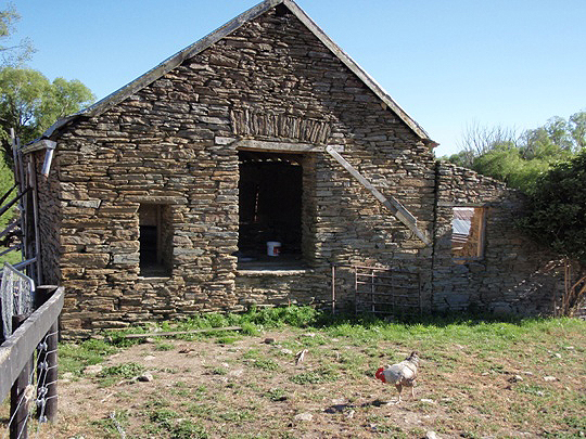
Physical Description and Analysis: Butler's Farm is on State Highway 8 in the area known in 2008 as Fruitlands. Fruitlands is located mainly on the flood plain of Obelisk Creek and extends towards Butchers Creek in the north. Running parallel to the west of the valley is the Old Man Range; to the east is the Roxburgh Gorge of the Clutha River. The remains of miners' cottages, farmers' houses and public buildings such as hotels are evident throughout Fruitlands providing a reminder of the importance of the area historically as a mining and farming district. Local historian John McCraw considers Butler's Farm as 'perhaps the most striking and easily visible landmark in present day Fruitlands.' Butler's Farm is set in pasture land surrounded by the outstanding landscape marked by barren hills with rocky outcrops. Constructed of local stone, the Farm makes a special contribution to this landscape, and is a noted feature for travellers passing through the district. At the time the farm buildings were built, Bald Hill Flat was the focus of a developing community and there are ruins of various stone and sod buildings in the area, which gives Fruitlands its particular character. Nearby buildings such as the Cape Broom Hotel and Dairy (Category II, Record No. 3241) and Mitchell's Cottage (Category I Record No. 337), as well as Butler's Farm contribute to the historical landscape of the area. The buildings themselves face north. The house is sited nearest the road, a little apart from the rest of the buildings. The surrounding plantings are of willow and poplars with remnant fruit tree plantings to the north east of the homestead. The House: The house is built of shaped stone, brought to course, laid with lime mortar. The house is square in plan and is a storey and a half. There are brick chimneys projecting from the corrugated iron roof on the east and west elevations. The principal elevation, facing north, has a single centrally placed door, flanked by windows on either site. The windows and door have flat arches with vertically placed stones. The ground floor windows are paired double hung windows with six lights. The door is a four-panelled timber door. Two small gable dormers project from the roof, with paired three-light casement windows. The gable ends of the dormers show the remains of a fleur-de-lis motif, and are clad in horizontal tongue and groove boards. The east side elevation has a centrally placed four-panelled door. There is a window opening to the right of the door on the ground floor. This window is blocked off. There is a small window opening just below the eave which may have matched a small dormer evident in historic photographs. The west side elevation has a double hung window with paired six-lights on the left hand side of the ground floor. There is a small dormer window at the top right of that elevation, its small gable projects from the roof, and the base of the window is set in the side wall. It has paired three-light casement windows which match the dormers on the north elevation. The rear south elevation has two window openings at ground floor level. One has remnants of its frame left in situ, the other is open. The remnant frame indicates that the window opening probably matched the others at ground floor level. At the first floor level there is a large dormer with no joinery remaining. Remnant door joinery in the upstairs hallway indicates that this opening originally had paired half-glazed doors. The house has four rooms and a hallway on the ground floor. The front door opens into the hallway. On the right side of the hallway are timber stairs to the first floor. On the ground floor the hallway continues past the stairway. The main entrance hall is match lined with vertical tongue and groove timber on the walls below the dado, and horizontal tongue and groove timber above the dado rail. The ceiling is also match lined. Both the walls and ceilings are painted. There is a cupboard under the stairs. The hallway then runs perpendicular to the main entrance door. The front left hand room is lined with wallpaper in poor condition. It does not have a fireplace. The left hand rear room housed the kitchen. A Shacklock No.1 Coal Range is still in situ on the east wall. This room is lined with layers of paper, including some newspaper. The wall linings are in poor condition, but provide evidence of the various wall coverings used in the room. The timber floor shows evidence of being lined by both newspaper, and later by linoleum. The floor is in poor condition, and is holed in places. The right front room is lined with paper over tongue and groove timber. There is a fireplace in the west wall with a handsome timber fire surround, with fluted side columns and panelling. The right rear room has a fireplace. Brick effect wallpaper up to window sill height, with a narrow wallpaper dado, and wallpaper again to the ceiling. The timber stairs have fret worked balustrades. The stairs are in poor condition. The newel posts at the top and bottom of the stairs are finely detailed. The upstairs hallway is match lined in a similar style to the downstairs hallway. There is a cupboard on the north wall between the two front rooms. There are six rooms on the upper floor. The two central rooms have no exterior windows, with light provided from internal windows. The rooms are lined with a variety of finishes, including wallpaper on scrim over timber boards, and plaster render. The wall coverings are in poor condition. There is a large amount of newspapers and magazines dating from around the 1940s in the upstairs rooms. The rear left room appears to have been used as a store as there is wall mounted shelving remaining, with some preserves and other items still in situ. There are no fireplaces in the upper rooms. From an initial assessment it appears that there is a significant documentary record to support an understanding of the McCambridge family during the 1930s through to the 1950s. Documentary evidence includes invoices, receipts, brochures, magazines and other journals and newspapers. There is also a collection of bottles and other food containers on site. The house is unchanged from the 1950s and exists as an artefact which, through the fittings, interior décor and finishes, and the associated collection of materials provides documentation of its period of occupation. The Barn: The barn is a two-storeyed single-gabled structure, rectangular in plan. It is oriented north south and is built into the gently sloping hill at the south end, providing ground level access on the south elevation. On the north elevation there are two openings - a window opening (boarded up) on the ground floor level and a larger door opening on the first floor level with the remains of a winch evident above the opening. Part of the west elevation has collapsed and has been braced. The south elevation has a single opening providing access to the first floor of the barn. The east elevation is partly connecting to the adjoining building. There is a door and window (boarded up) at ground level, and two windows (both boarded up) at first floor level. The interior of the first floor is an open space with a timber floor. There is a grain chute connecting the upper and lower floors. There are some timber partitioning and gated sections on this floor which on closer investigation may indicate the function of this lower part of the building. The barn has some minor modifications relating to its use as a film set. Other Outbuildings: The outbuildings are arranged around a yard, walled on three sides. On the south side of the courtyard are the barn (which provides the wall on the west side), and three other connected structures. Immediately to the east of the barn is a building which is in a state of partial collapse. Given the surviving interior elements and fixtures this building has been identified as the stable. It has no roof. The remaining gable end shows that this was a single gable structure. It did have a window opening in the south wall, as part of the opening remains. The north wall has partially collapsed. The remaining section shows that there was a single window opening (boarded up) on this wall. Adjoining this building is another single-gabled building, thought to have been the cow byre. This building has two large door openings with timber doors and a smaller window opening on the north elevation facing the courtyard. There is a window opening high on the gable end of the east elevation. There is evidence of roughly-hewn stone flagging on the floor. There is evidence of a stone ridge on the floor which may indicate partitioning of the pens from the passage. Immediately to the east of the cow byre there is an open-fronted structure which looks to have been a cart shed or implement shed. A wall with an opening at the south end forms the eastern boundary of the yard. On the north side of the yard is another row of buildings, with a passage through the centre. These are all single storey, single-gabled buildings. The eastern-most structure has no roof, but shows evidence of pens. These buildings would appear to have been used in processing, probably as a dairy and with its related functions. The group of the buildings, including the house, express the development of the increasing scale of the farm, the farm operations, and the domestic arrangements to support the farm operation. Study of the buildings has the potential to reveal the nature of these changes, and in turn to provide insight in the workings of a nineteenth century farm. Parts of these buildings have been modified in a minor way for use as a film set in the last decade or so. Some new joinery has been installed; some stonework has been built up. The extent of these changes is still being identified. There are several other significant stone buildings still standing in the Fruitlands area, dating to the era of the Butler buildings. Two former hotels stand several kilometres to the south of the Butler buildings on the west of State Highway 8. Travelling towards the south, the first of these is the original façade of the former Speargrass Hotel, retained for use as the Fruitlands Gallery in a reconstruction that was carried out in 1987. Several hundred metres past the former Speargrass Hotel the remains of the Cape Broom Hotel and its hexagonal dairy can be seen. An important Category I historic place is Mitchell's Cottage, about 500 metres off State Highway 8 along Symes Road, to the north of the Butler buildings. This house was completed in 1904 by Shetland Islanders John Mitchell and his brother Andrew, renowned for their stonemason skills, who both worked as miners at Bald Hill Flat and in the Old Man Range. The ruins of other similar structures, built of stone and of mud brick are located along the highway. There is also archaeological evidence of gold mining in the area, as well as a number of rock shelters associated with this industry that were used as residences.
Public NZAA Number
G42/249
Completion Date
2nd February 2009
Report Written By
Heather Bauchop
Information Sources
Angus, 1977
J. Angus, One Hundred Years of Vincent County Council, Vincent County Council, Dunedin, 1977
Harrison, 1982
A. Harrison, 'Lake Roxburgh Archaeological Survey', NZHPT, Cromwell, 1982
McCraw, 2003
J. McCraw, Gold on the Dunstan, Square One Press, Dunedin, 2003
Moore, 1953 (reprint 1978)
C. Moore, The Dunstan, Whitcombe & Tombs, Dunedin, (First published 1953, Capper Press reprint 1978)
McCraw, 2005
John McCraw, The Story of Fruitgrowing and Irrigation in the Alexandra-Clyde District, Square One Press, Dunedin, 2005
McCraw, 2007
John McCraw, Early Days on the Dunstan, Square One Press, Dunedin, 2007
Frederick, 1949
Frederick W.G. Miller, There was Gold in the River, A.H. and A.W. Reed, Wellington, 1949
Report Written By
A fully referenced registration report is available from the NZHPT Otago / Southland Area Office Please note that entry on the New Zealand Heritage List/Rarangi Korero identifies only the heritage values of the property concerned, and should not be construed as advice on the state of the property, or as a comment of its soundness or safety, including in regard to earthquake risk, safety in the event of fire, or insanitary conditions.
Current Usages
Uses: Vacant
Specific Usage: Vacant
Former Usages
General Usage:: Agriculture
Specific Usage: Barn
General Usage:: Agriculture
Specific Usage: Dairy/ buttery/cheese house
General Usage:: Agriculture
Specific Usage: Farm
General Usage:: Agriculture
Specific Usage: Fruit shed/ store
General Usage:: Agriculture
Specific Usage: Henhouse
General Usage:: Agriculture
Specific Usage: Stables
Stay up to date with Heritage this month
