

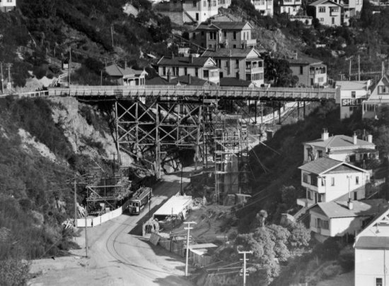
Plans to build a new Upland Road bridge to replace an ‘obsolete’ late nineteenth century timber trestle bridge were developed in 1929. The existing Kelburn Viaduct could not cope with modern traffic needs because it was too narrow to allow two lanes of motor traffic. The Evening Post followed the replacement structure’s construction closely, publishing photographs most months between 1930 and 1931, which indicates a high level of public interest in the project.
The new bridge, constructed by W Hodges, meant traffic could flow to and from the western suburbs more efficiently. The mayor at the time, George Alexander Troup (1863–1941), who had previously been an important Railways Department architect, applauded Hart’s team for the Kelburn Viaduct’s design. Before becoming City Engineer in 1926, Hart had considerable municipal engineering experience in England, and over the next decade was responsible for several major projects, including the Mount Victoria Tunnel.
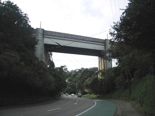
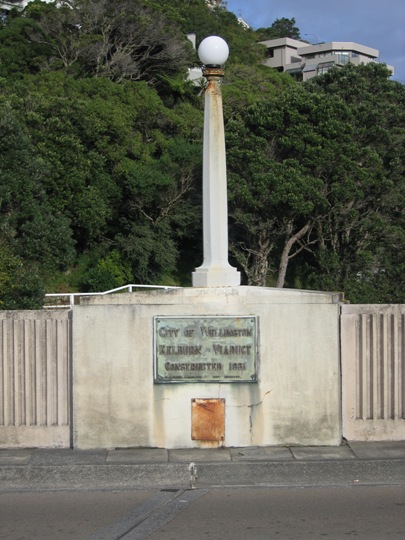
At its opening in May 1931 the Kelburn Viaduct was heralded as a ‘work of art’. However, the structure, which looms 20 metres above Glenmore Street, has subsequently also been described as ‘rather ponderous’. The bridge consists of three spans supported by two substantial tapering piers and the total length is 71.3 metres. Typical of the popular architectural style of the period, Art Deco-inspired lamp posts extended upwards from the piers, as well as marking each end of the structure. The spherical light-fittings were removed circa 2014. The original balustraded parapets were replaced circa 1972. These form solid concrete traffic barriers with ribbing on each side, positioned between the original curved concrete wing walls located at each end of the bridge. The southern pedestrian walkway is no longer accessible because it has been reduced to provide greater vehicular traffic lane width. Therefore, views of the bronze commemorative opening plaque on the parapet’s interior, beneath the southeast lamp post, are limited.
List Entry Information
Status
Listed
List Entry Status
Historic Place Category 2
Access
Able to Visit
List Number
3333
Date Entered
28th June 1984
Date of Effect
28th June 1984
City/District Council
Wellington City
Region
Wellington Region
Extent of List Entry
Extent includes part of the land described as Legal Road, Wellington Land District and the structure known as Kelburn Viaduct thereon, including its wing walls and abutments. Refer to the extent map tabled at the Rārangi Kōrero Committee Meeting on 6 September 2017.
Legal description
Legal Road, Wellington Land District
Construction Professional
Name
Hart, George Alfred James
Type
Engineer
Biography
No biography is currently available for this construction professional
Name
W. Hodges
Type
Builder
Biography
Builder of the Kelburn Viaduct, 1930-31 and the Oriental Parade Band Rotunda (Former), 1936-37
Construction Details
Start Year
1972
startYearCirca
Type
Modification
Description
Parapets replaced
Start Year
2014
startYearCirca
Type
Modification
Description
Light fittings removed
Start Year
1930
Finish Year
1931
Type
Original Construction
Historical and Associated Iwi / Hapū / Whānau
Completion Date
23rd June 2017
Report Written By
Karen Astwood
Information Sources
Thornton, 2001
Geoffrey Thornton, Bridging the Gap, Early Bridges in New Zealand 1830-1939, Auckland, 2001
Other Information
This place was identified as significant under previous legislation with different information requirements. It remains significant under the current legislation. There is opportunity under our legislation and policies to add to this information. Further information about this place may be available from the Central Regional Office of Heritage New Zealand Pouhere Taonga. Please note that entry on the New Zealand Heritage List/Rarangi Korero identifies only the heritage values of the property concerned, and should not be construed as advice on the state of the property, or as a comment of its soundness or safety, including in regard to earthquake risk, safety in the event of fire, or insanitary conditions. A fully referenced upgrade report is available on request from the Central Region Office of Heritage New Zealand.
Current Usages
Uses: Transport
Specific Usage: Bridge/ Viaduct
Current Usages
Uses: Transport
Specific Usage: Bridge/ Viaduct
Location
Sign up to hear more
Get the latest heritage news, features and events delivered
straight to your inbox.
