

Alexandra sits at the confluence of the Clutha/Mata-au and Manuherikia Rivers. Residents were keen for a bridge to replace the first river crossing service – a punt which had to negotiate the fearsome Clutha/Mata-au. When flooding in 1878 washed away the nearest bridge upstream at Clyde, the need for a bridge became urgent.
Vincent County engineer Leslie Duncan Macgeorge (1854-1939) designed for Alexandra a suspension bridge with two imposing schist stone piers and towers and abutments, with the assistance of consulting engineer Robert Hay (1847-1928). At the time of its construction, it was the longest suspension bridge in the country, exceeding the length of Macgeorge’s earlier suspension bridge designs. The total length of the roadway from bank to bank was 554 feet (168 metres). The centre arch was 262 feet 6 inches (close to 80 metres). The abutment on the east side was a solid mass of masonry 83 feet long and 26 feet high (25 by 8 metres) made up of blocks of stone on piles of totara and black pine, covered with a double deck of planking. The suspension wires were fixed to anchor rods. On the west site the moorings and pier were all on solid rock. The piers rose over 90 feet (27 metres) from the bedrock in the river. Eight three inch cables supported the structure. The height above the river at the centre of the bridge was 40 to 50 feet (12-15 metres).
Construction began in 1879 with Jeremiah Drummey (b.1833), William Beresford and James Simmond, winning the contract. Alexandra Bridge opened amidst local fanfare on 1 June 1882.
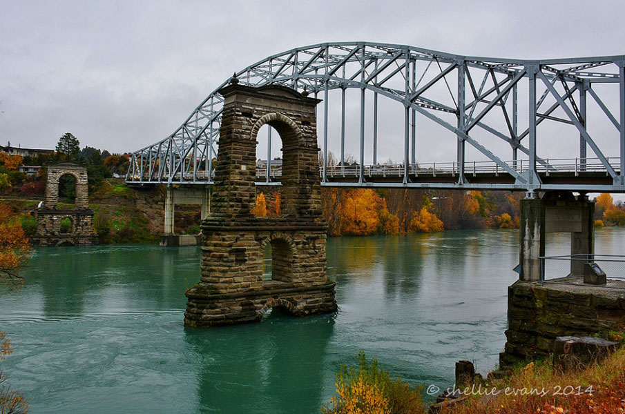
Alexandra Bridge was a key link on State Highway 8. By the 1950s however, the increasing traffic load was deemed to be too much for the single lane structure. A new bridge was built in 1958, parallel and just upstream of the old bridge. The old bridge’s suspension cables and decks were removed. The piers and towers, abutments and cable anchorages remain.
The Alexandra Bridge Piers and Towers and Abutments have outstanding engineering significance as the legacy of the important late nineteenth century local engineer, Macgeorge. They are a lasting tribute to the technical skill of both Macgeorge and the bridge’s contractors because of the bridge’s scale, design and survival. The structures are landmarks in Central Otago.
In 2013 the remaining elements of the Alexandra Bridge are an icon for the town.
List Entry Information
Status
Listed
List Entry Status
Historic Place Category 1
Access
Private/No Public Access
List Number
349
Date Entered
7th April 1983
Date of Effect
7th April 1983
City/District Council
Central Otago District
Region
Otago Region
Extent of List Entry
Extent includes part of the land described as Sec 16 SO 307905 (NZ Gazette, 2003, p. 2024), Legal Road, Legal River (Sec 2 SO 24450), and part of the land described as Sec 189 Blk I Fraser SD (RT 467446), Otago Land District, and the structures associated with the Alexandra Bridge (Former) thereon. Included in the registration are the piers and towers, abutments, anchorages, and archaeological remains associated with the Alexandra Bridge (Former). (Refer to map in Appendix 1 of the registration report for further information).
Legal description
Sec 16 SO 307905 (NZ Gazette, 2003, p. 2024), Legal Road, Legal River (Sec 2 SO 24450), Sec 189 Blk I Fraser SD (RT 467446), Otago Land District
Location Description
The bridge piers, towers and abutments are located in a line between Old Bridge Road on the Bridge Hill side (true right) of the Clutha/Mata-au and Rivers Street (true left) on the Alexandra township side of the river.
Why is this place significant?
Historic Significance
Historical Significance or Value The former Alexandra Bridge has historical significance. The development of infrastructure such as roads and bridges in New Zealand is significant on both a local and a national level. For communities such as Alexandra, bridges were a vital link to the wider world, particularly when the town’s history is so bound with the powerful rivers running in the gorge below the town. Alexandra Bridge was part of the first wave of bridge building in that area of Otago and is the work of Vincent County Engineer Leslie Duncan Macgeorge who was responsible for a number of bridge designs in Central Otago from the 1870s through to the turn of the century. The subsequent removal of the decking illustrates the second wave of history of such structures, when they were either adapted for a modern use, or became obsolete. The survival of the structures associated with the Alexandra Bridge and recognition of their importance as icons and memorials to the nineteenth century builders and engineers reflects their new role as historic attractions in Alexandra.
Physical Significance
Aesthetic Significance or Value Described as one of the ‘most beautiful suspension bridges ever built in New Zealand’ and, on its opening, as a having an ‘airy lightness and grace’ the surviving piers and towers retain a strong visual appeal, standing alongside the 1958 bridge. The bridge crossed the Clutha/Mata-au, one of the country’s swiftest rivers, and the survival of the structures associated with the bridge demonstrate their strength standing mid-stream in this powerful river. They are built in stone, a vernacular material of Central Otago, and along with other surviving structures associated with Macgeorge – which include the piers of the Earnscleugh Bridge and the Daniel O’Connoll Bridge at Ophir. Archaeological Significance or Value The remaining bridge structure provides an understanding of nineteenth century construction technology. There is potential for further investigation of the original fabric to understand detailed aspects of the construction, including the innovative use of concrete, the composition of mortar, and the other surviving structural elements of the bridge. Technological Significance or Value The Alexandra Bridge (Former) has special technological significance, with the surviving elements illustrating the engineering solutions for the construction of what was one of the longest suspension bridges in the country in 1882, over the Clutha/Mata-au, among New Zealand’s swiftest rivers and a massive flow of water to withstand.
Why is this place Category 1 / Category 2?
Detail Of Assessed Criteria
(a) The extent to which the place reflects important or representative aspects of New Zealand history The history of Alexandra Bridge reflects the development of the physical infrastructure of inland Otago. The bridging of the rivers was an issue for many small riverside towns. For Alexandra, bounded on two sides by the Clutha/Mata-au and the Manuherikia Rivers it was a particularly significant issue. The bridge illustrates the importance of the county engineer’s role in facilitating communications through the bridge-building programme. Alexandra Bridge also illustrates the effect of the development of the road network and increase in vehicular traffic, which resulted in a new bridge being constructed in 1958. (b) The association of the place with events, persons, or ideas of importance in New Zealand history Alexandra Bridge (Former) was designed by Vincent County Engineer Leslie Duncan Macgeorge. Macgeorge is representative of the nineteenth century surveyor come engineer who was a pivotal figure in the development of the provinces, designing bridges which allowed for the opening of Central Otago. The Alexandra Bridge was the pinnacle of Macgeorge’s work – the longest suspension bridge in the country. (e) The community association with, or public esteem for the place The Alexandra Bridge (Former) is held in high public esteem as shown by the formation of a working group to consider the future of the surviving structures. It was built as a result as a result of community agitation, showing the importance of the structure to the town and region. It’s retention after the removal of the decking and cables as a memorial to the town also shows its significance. Esteem is also shown by the use of images of the bridge as an icon of the town. (f) The potential of the place for public education Interpretation is already in place which describes the significance of the surviving structures associated with Alexandra Bridge; as such there is already some public education being provided. (g) The technical accomplishment or value, or design of the place Alexandra Bridge was at the time of construction to be New Zealand’s longest suspension bridge. The surviving piers and towers, abutments and associated structures have special technological significance representing the pinnacle of construction technology at that time because the bridge had to be strong enough to survive the power of the Clutha/Mata-au, among the country’s swiftest and most powerful rivers which, in flood, had already claimed several earlier bridges. (h) The symbolic or commemorative value of the place Alexandra Bridge has been retained and recognised as a memorial to the pioneer Central Otago engineers. A plaque describing the significance of the bridge is mounted on the riverbank. (k) The extent to which the place forms part of a wider historical and cultural complex or historical and cultural landscape Alexandra Bridge forms part of the cultural and historic landscape of Alexandra and Central Otago. Other historic bridges in the area designed by Macgeorge such as the Daniel O’Connell Bridge, which is a suspension bridge at Ophir, and the Earnscleugh Bridge at Clyde and Shaky Bridge (the Manuherikia Light Traffic Bridge), both of which are built with similar schist piers and towers. Summary of Significance or Values The impressive piers, towers and abutments, which are what remains of the 1882 Alexandra Bridge (Former), stand as a monument to its engineers and contractors, having stood strong in the mighty Clutha/Mata-au River for over 130 years, an outstanding technological achievement, in one of New Zealand’s swiftest rivers. Though these are the remnants of the suspension bridge, the decking and cables having been removed in 1958, they are a reminder of the importance of bridges in this water riven country. The surviving elements illustrate the engineering solutions for the construction of what was one of the largest suspension bridges in the country in 1882.
Construction Professional
Name
Simmonds, James
Type
Builder
Biography
James Simmond – Builder - was a Tasmanian-born cabinet maker before following gold to Otago in 1862 and turning his hand to building and was a storekeeper and later mayor of Alexandra and politician. Source: Registration Review Report for Alexandra Bridge (Former), Alexandra, Sept 2013.
Name
Macgeorge, Leslie Duncan
Type
Engineer
Biography
Leslie Duncan Macgeorge (1854-1939) was born in Adelaide and trained as a surveyor. He came to New Zealand in the 1870s. In 1876 he transferred to Central Otago. He held the position of County Engineer until 1902, after which he entered private practice in Dunedin and Timaru. He retired to Melbourne, and died there in 1939. Source: Registration Review Report for Alexandra Bridge (Former), Alexandra, Sept 2013.
Name
Drummey, Jeremiah
Type
Builder
Biography
Jeremiah Drummey – Builder - was born in Canada and trained as a carpenter. He came to Otago in 1861 and to Alexandra the following year. He was a miner and later on the West Coast built the Upper Buller Bridge. Returning to Otago in 1870 he worked as a contractor building buildings, roads, bridges and water races. Source: Registration Review Report for Alexandra Bridge (Former), Alexandra, Sept 2013.
Name
Beresford, William
Type
Builder
Biography
William Beresford – Builder - was a wheelwright and carpenter, mayor of Alexandra in the early 1870s and a lobbyist for the construction of the Manuherikia Bridge. Source: Registration Review Report for Alexandra Bridge (Former), Alexandra, Sept 2013.
Name
Hay, Robert
Type
Engineer
Biography
Robert Hay (1847-1928) was a London-born civil engineer. He arrived in New Zealand in 1865 and worked first for the Provincial Government, and then for David Proudfoot, as an assistant in the construction of the Port Chalmers railway. From 1876 until 1920 he was in private practice, and was engineer for the Taieri and Tuapeka counties, as well as for the Dunedin boroughs of North East Valley, West Harbour, Mornington and St Kilda, and he was consulting engineer to the City of Dunedin. He worked on various water drainage and sewerage works, railways, bridges, as well as hydroelectric and hydraulic installations throughout New Zealand. Source: Registration Review Report for Alexandra Bridge (Former), Alexandra, Sept 2013.
Construction Details
Start Year
1958
Type
Modification
Description
Decks and cables removed
Start Year
1879
Finish Year
1882
Type
Original Construction
Description
2 June 1882 Bridge opened
Construction Materials
Stone
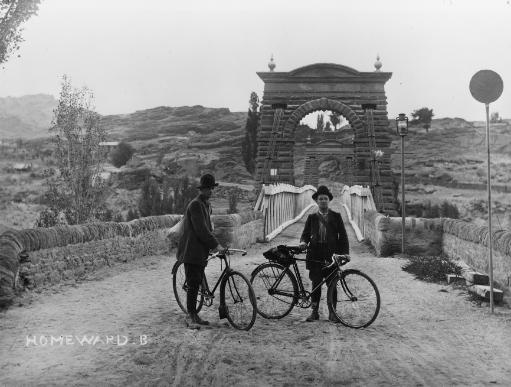
Rivers Maori had long recognised that rivers were key to traversing inland areas of the Otago and Southland, particularly the mighty Clutha/Mata-au, one of the world’s top ten swiftest rivers, which runs 338 kilometres from Wanaka to the sea. Guides like Te Raki shared their knowledge of routes with Europeans, giving them their first glimpse of the interior of Otago in 1853. Maori made use of ara, pathways or routes, such as the one through the Nevis Valley, which used a natural rock bridge to cross the Kawarau River. For European pastoralists and the rush of miners who followed after the discovery of gold up Dunstan Gorge in 1862, the need for safe crossing was also vital to enable them, and in the case of pastoralists, their stock, to move around the province. New Zealand rivers were faster and more changeable than many settlers were used to. Water transport, including ferries and punts, was vital when roads and bridges were poor or non-existent. The increasing numbers of wagons and other wheeled traffic that came with a settled population made formed routes and crossings even more important. The Vogel public works scheme in the 1870s saw a great push in infrastructure development, including bridge building. Bridging the barrier The Clutha/Mata-au (or Molyneux) River was a major barrier. The town of Alexandra grew up at the confluence of the Clutha/Mata-au and the Manuherikia Rivers. A ferry service was established there in 1868. The river was mighty in flood; a major flood in 1878 swept the Clyde Bridge away along with three other bridges on that river. The local lobbying for a safer crossing gained momentum after the flood. The Manuherikia was bridged in 1879 by a small suspension bridge (Shaky Bridge, Category 2 historic place, Register No. 2082). Tenders for a bridge across the Clutha/Mata-au in 1874 were unsuccessful, but efforts continued. In July 1878 the Vincent County Council commissioned two engineers – Leslie Duncan Macgeorge and Robert Hay to come up with another design. Macgeorge drew up plans for the ‘horse bridge’ and surveyed the proposed site in June 1877. Macgeorge was well known for his design of such suspension bridges. Adelaide-born and trained Macgeorge was appointed as Vincent County engineer at the age of twenty three. He trained in the South Australian Public Works Department, moving to a similar position in Otago before being appointed District Engineer for the Otago Provincial Government in Cromwell in 1876. Macgeorge held the position of County Engineer until 1901, when he was replaced by G.L. Cuthbertson. He retired to Melbourne, dying there in 1939. Macgeorge’s assistant, Robert Hay, was a Dunedin-based engineer. He was Borough Engineer, and had been involved in the construction of a graving dock at Port Chalmers, so was presumably familiar with working in wet environments. Similar schist piers also designed by Macgeorge are still in use on the Earnscleugh Bridge at Clyde (built 1874, Category 2 historic place, Register No. 2370). The small, elegant Daniel O’Connell Bridge at Ophir was also designed by Macgeorge (built 1880, Category 1 historic place, Register No. 338). Alexandra Bridge was the pinnacle of Macgeorge’s bridge designs, the longest suspension bridge in the country, crossing one of the country’s swiftest rivers. The catastrophic 1878 flood hastened the Council’s considerations; the ferry was vulnerable and the Clyde Bridge was no longer there. Prominent politician Vincent Pyke and Councillor Michael McGinnis championed Alexandra as the location for a replacement structure. The first design was deemed too expensive leading Macgeorge to rework his design. The £16,111 tender of local men W. Beresford, J.Simmonds and J. Drummey, was successful. Jeremiah Drummey was born in Canada and trained as a carpenter. He came to Otago in 1861 and to Alexandra the following year. He was a miner and later on the West Coast built the Upper Buller Bridge. Returning to Otago in 1870 he worked as a contractor building buildings, roads, bridges and water races. James Simmond was a Tasmanian-born cabinet maker before following gold to Otago in 1862 and turning his hand to building and was a storekeeper and later mayor of Alexandra and politician. William Beresford was a wheelwright and carpenter, mayor of Alexandra in the early 1870s and a lobbyist for the construction of the Manuherikia Bridge. Construction of the bridge took three years. The geology of the Clutha/Mata-au River posed some problems for the engineers. While there was solid schist on the southeast side of the river, the northwest side had only a thin crust of stone, necessitating the construction of a concrete raft foundation for the pier on the Alexandra side of the river. Flooding caused delays and the 1880s depression which saw the Government stopping infrastructure subsidies to local councils caused major problems. A special appeal was made to the Government in 1881 which finally secured funding. The Alexandra Bridge was opened on 1 June 1882. Spectators travelled from around Central Otago, the largest gathering Alexandra had seen. Councillor McGinnis on opening the bridge said that ‘works of such magnitude over the large and dangerous rivers of New Zealand, and on the main arterial highways of the country were decidedly national works.’ ‘One of the largest, strongest most beautiful bridges in the colony’ was named the ‘Alexandra Bridge’ recalling the town’s name after Princess Alexandra of Denmark (1844-1925), then Princess of Wales and the future queen. Architect, engineer and historian Geoffrey Thornton describes it as ‘one of the most beautiful suspension bridges ever built in New Zealand.’ The total length of the roadway from bank to bank was 554 feet (168 metres). The centre arch was 262 feet 6 inches (close to 80 metres). The abutment on the east side was a solid mass of masonry 83 feet long and 26 feet high (25 by 8 metres) made up of blocks of stone on piles of totara and black pine, covered with a double deck of planking. The suspension wires were fixed to anchor rods. On the west site the moorings and pier were all on solid rock. The piers rose over 90 feet (27 metres) from the bedrock in the river. Eight three inch cables supported the structure. The height above the river at the centre of the bridge was 40 to 50 feet (12-15 metres). The approach on the western side was through a cutting. The stonework was pointed with cement. An Otago Daily Times reporter described the bridge as a structure ‘with a look of airy lightness and grace which makes it an ornamental as wells as highly useful piece of work. This light appearance is greatly added to by the relief which is afforded by having in the piers three arches, two being below the roadway, and the arch of the roadway itself above the road….The whole design and the carrying out of it reflects the utmost credit on the engineer and contractors.’ Alexandra Bridge was the largest of Leslie Macgeorge’s Central Otago suspension bridges. It was, as noted at the time of construction ‘the largest of its kind in the Colony, and is a great undertaking for a young County to carry out.’ Road Traffic The bridge was in poor condition by 1936 and there was discussion about the possibility of building a new bridge. In 1937 there was a proposal to build a two-way deck with the existing piers partially dismantled and altered. The Public Works Inspector preferred a new structure and surveys were made of possible sites. By the middle of the twentieth century the increase in road traffic on the arterial route between Alexandra and Roxburgh, and as a link between Alexandra and the suburb of Bridge Hill saw the old bridge under pressure – a single lane bridge could not cope with the volume. In 1958 a new steel bridge was constructed, running parallel but upriver to the 1882 structure. There was some lobbying for retaining the old bridge – Sir William Bodkin, MP for Central Otago campaigned for retention of the bridge as a monument to the early pioneers. Although there was discussion about keeping the old structure for pedestrian use, concern about the condition of the bridge and the cost of its on-going maintenance saw the deck and suspension cables removed. The freestanding piers/towers and the abutments on the river bank remained. The surviving piers have become an icon for Alexandra. In 2002 the Alexandra Museum hosted local historian Professor JD McCraw who spoke of the importance of the bridge. As a result of this lecture there was renewed interest in the bridge and the Alexandra Community Board invited the public to form a group to consider the welfare of the piers, and a working group was formed. A conservation maintenance report was completed in 2005. In 2008 the group was successful in having the piers floodlit. The bridge piers have become icons or emblems for many local businesses. A structural assessment and an underwater survey of the piers have been completed and there have been on-going discussions about the future of the structures. The possibility of reinstating a carriageway for cyclists and pedestrians across the historic structure has been raised. In 2013 the surviving elements of former Alexandra Bridge stand as a monument to the nineteenth century engineers and contractors who built this impressive structure.
Rivers Maori had long recognised that rivers were key to traversing inland areas of the Otago and Southland, particularly the mighty Clutha/Mata-au, one of the world’s top ten swiftest rivers, which runs 338 kilometres from Wanaka to the sea. Guides like Te Raki shared their knowledge of routes with Europeans, giving them their first glimpse of the interior of Otago in 1853. Maori made use of ara, pathways or routes, such as the one through the Nevis Valley, which used a natural rock bridge to cross the Kawarau River. For European pastoralists and the rush of miners who followed after the discovery of gold up Dunstan Gorge in 1862, the need for safe crossing was also vital to enable them, and in the case of pastoralists, their stock, to move around the province. New Zealand rivers were faster and more changeable than many settlers were used to. Water transport, including ferries and punts, was vital when roads and bridges were poor or non-existent. The increasing numbers of wagons and other wheeled traffic that came with a settled population made formed routes and crossings even more important. The Vogel public works scheme in the 1870s saw a great push in infrastructure development, including bridge building. Bridging the barrier The Clutha/Mata-au (or Molyneux) River was a major barrier. The town of Alexandra grew up at the confluence of the Clutha/Mata-au and the Manuherikia Rivers. A ferry service was established there in 1868. The river was mighty in flood; a major flood in 1878 swept the Clyde Bridge away along with three other bridges on that river. The local lobbying for a safer crossing gained momentum after the flood. The Manuherikia was bridged in 1879 by a small suspension bridge (Shaky Bridge, Category 2 historic place, Register No. 2082). Tenders for a bridge across the Clutha/Mata-au in 1874 were unsuccessful, but efforts continued. In July 1878 the Vincent County Council commissioned two engineers – Leslie Duncan Macgeorge and Robert Hay to come up with another design. Macgeorge drew up plans for the ‘horse bridge’ and surveyed the proposed site in June 1877. Macgeorge was well known for his design of such suspension bridges. Adelaide-born and trained Macgeorge was appointed as Vincent County engineer at the age of twenty three. He trained in the South Australian Public Works Department, moving to a similar position in Otago before being appointed District Engineer for the Otago Provincial Government in Cromwell in 1876. Macgeorge held the position of County Engineer until 1901, when he was replaced by G.L. Cuthbertson. He retired to Melbourne, dying there in 1939. Macgeorge’s assistant, Robert Hay, was a Dunedin-based engineer. He was Borough Engineer, and had been involved in the construction of a graving dock at Port Chalmers, so was presumably familiar with working in wet environments. Similar schist piers also designed by Macgeorge are still in use on the Earnscleugh Bridge at Clyde (built 1874, Category 2 historic place, Register No. 2370). The small, elegant Daniel O’Connell Bridge at Ophir was also designed by Macgeorge (built 1880, Category 1 historic place, Register No. 338). Alexandra Bridge was the pinnacle of Macgeorge’s bridge designs, the longest suspension bridge in the country, crossing one of the country’s swiftest rivers. The catastrophic 1878 flood hastened the Council’s considerations; the ferry was vulnerable and the Clyde Bridge was no longer there. Prominent politician Vincent Pyke and Councillor Michael McGinnis championed Alexandra as the location for a replacement structure. The first design was deemed too expensive leading Macgeorge to rework his design. The £16,111 tender of local men W. Beresford, J.Simmonds and J. Drummey, was successful. Jeremiah Drummey was born in Canada and trained as a carpenter. He came to Otago in 1861 and to Alexandra the following year. He was a miner and later on the West Coast built the Upper Buller Bridge. Returning to Otago in 1870 he worked as a contractor building buildings, roads, bridges and water races. James Simmond was a Tasmanian-born cabinet maker before following gold to Otago in 1862 and turning his hand to building and was a storekeeper and later mayor of Alexandra and politician. William Beresford was a wheelwright and carpenter, mayor of Alexandra in the early 1870s and a lobbyist for the construction of the Manuherikia Bridge. Construction of the bridge took three years. The geology of the Clutha/Mata-au River posed some problems for the engineers. While there was solid schist on the southeast side of the river, the northwest side had only a thin crust of stone, necessitating the construction of a concrete raft foundation for the pier on the Alexandra side of the river. Flooding caused delays and the 1880s depression which saw the Government stopping infrastructure subsidies to local councils caused major problems. A special appeal was made to the Government in 1881 which finally secured funding. The Alexandra Bridge was opened on 1 June 1882. Spectators travelled from around Central Otago, the largest gathering Alexandra had seen. Councillor McGinnis on opening the bridge said that ‘works of such magnitude over the large and dangerous rivers of New Zealand, and on the main arterial highways of the country were decidedly national works.’ ‘One of the largest, strongest most beautiful bridges in the colony’ was named the ‘Alexandra Bridge’ recalling the town’s name after Princess Alexandra of Denmark (1844-1925), then Princess of Wales and the future queen. Architect, engineer and historian Geoffrey Thornton describes it as ‘one of the most beautiful suspension bridges ever built in New Zealand.’ The total length of the roadway from bank to bank was 554 feet (168 metres). The centre arch was 262 feet 6 inches (close to 80 metres). The abutment on the east side was a solid mass of masonry 83 feet long and 26 feet high (25 by 8 metres) made up of blocks of stone on piles of totara and black pine, covered with a double deck of planking. The suspension wires were fixed to anchor rods. On the west site the moorings and pier were all on solid rock. The piers rose over 90 feet (27 metres) from the bedrock in the river. Eight three inch cables supported the structure. The height above the river at the centre of the bridge was 40 to 50 feet (12-15 metres). The approach on the western side was through a cutting. The stonework was pointed with cement. An Otago Daily Times reporter described the bridge as a structure ‘with a look of airy lightness and grace which makes it an ornamental as wells as highly useful piece of work. This light appearance is greatly added to by the relief which is afforded by having in the piers three arches, two being below the roadway, and the arch of the roadway itself above the road….The whole design and the carrying out of it reflects the utmost credit on the engineer and contractors.’ Alexandra Bridge was the largest of Leslie Macgeorge’s Central Otago suspension bridges. It was, as noted at the time of construction ‘the largest of its kind in the Colony, and is a great undertaking for a young County to carry out.’ Road Traffic The bridge was in poor condition by 1936 and there was discussion about the possibility of building a new bridge. In 1937 there was a proposal to build a two-way deck with the existing piers partially dismantled and altered. The Public Works Inspector preferred a new structure and surveys were made of possible sites. By the middle of the twentieth century the increase in road traffic on the arterial route between Alexandra and Roxburgh, and as a link between Alexandra and the suburb of Bridge Hill saw the old bridge under pressure – a single lane bridge could not cope with the volume. In 1958 a new steel bridge was constructed, running parallel but upriver to the 1882 structure. There was some lobbying for retaining the old bridge – Sir William Bodkin, MP for Central Otago campaigned for retention of the bridge as a monument to the early pioneers. Although there was discussion about keeping the old structure for pedestrian use, concern about the condition of the bridge and the cost of its on-going maintenance saw the deck and suspension cables removed. The freestanding piers/towers and the abutments on the river bank remained. The surviving piers have become an icon for Alexandra. In 2002 the Alexandra Museum hosted local historian Professor JD McCraw who spoke of the importance of the bridge. As a result of this lecture there was renewed interest in the bridge and the Alexandra Community Board invited the public to form a group to consider the welfare of the piers, and a working group was formed. A conservation maintenance report was completed in 2005. In 2008 the group was successful in having the piers floodlit. The bridge piers have become icons or emblems for many local businesses. A structural assessment and an underwater survey of the piers have been completed and there have been on-going discussions about the future of the structures. The possibility of reinstating a carriageway for cyclists and pedestrians across the historic structure has been raised. In 2013 the surviving elements of former Alexandra Bridge stand as a monument to the nineteenth century engineers and contractors who built this impressive structure.
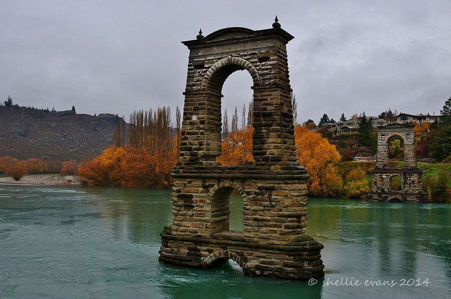
Current Description What remains of the former Alexandra Suspension Bridge are the abutments, piers and towers. The two piers and towers stand in the bed of the Clutha / Mata-au River, the foundations some six metres below the normal river level. Their form and the scale contribute to their strong visual impact – the remaining structures once supported a bridge of 168.3 metres (79.9 metre span between the piers and towers). Architect, engineer and historian Geoffrey Thornton points out that the schist masonry towers are vernacular features of Central Otago. Conservation architect Jackie Gillies describes the structure of each pier and tower as having: • a base (a low arched section just above normal water level, originally further above water level but levels were raised with the commissioning of the Roxburgh Hydro Dam downstream in the 1950s); • a first stage – an arched section defined by a string course with a semi-circular arch, schist voissoirs (wedge shaped element used in the construction of an arch) and keystone; • a second stage (through which the carriageway passed) with a semi-circular arch, schist voissoirs, keystone and string course. Two cable channels are located on either side of the arch. The iron cable arms remain in place. The channels have stone lintels with tooling to mimic mortar joints; • And a pediment which includes entablature. The pediment is classically-styled with a curved head. The entablature includes a cornice, plain frieze and architrave. Two urns or finials are mounted on the pediment. The towers and piers are constructed of locally-quarried schist stone, with a rubble core. The facing is of ashlar stonework. The stonework is rusticated, that is the exterior face of the stone is left rough rather than dressed. One of the stone quarries became the cutting to the south approach to the bridge. Significant elements of the fabric include the stonemason’s original tooling and marks and the scars of the former road deck and railings. Also associated are the cable channels and their internal mechanism and associated metalwork. The lower section of each pier is 5.4 metres by 3.6 metres. The upper section of the pier is 3.6 metres by 2.7 metres. Abutments The small south pier/abutment has stone capping, a timber bearing and may have associated archaeological evidence relating to the original stone posts that stood at either end of the pier. Similarly the north abutment may have archaeological evidence relating the cable anchorages and landing for the road deck. Cable anchorages are masonry tunnels built into the river bank. There are some sections of the braided wire cables in the anchorages and close to the small south pier. The north abutment has masonry walls of coursed stonework. Only the east face is accessible. There is potential for further investigation of the original fabric to understand detailed aspects of the construction, including the innovative use of concrete, the composition of mortar, and the other surviving structural elements of the bridge. Current Description What remains of the former Alexandra Suspension Bridge are the abutments, piers and towers. The two piers and towers stand in the bed of the Clutha / Mata-au River, the foundations some six metres below the normal river level. Their form and the scale contribute to their strong visual impact – the remaining structures once supported a bridge of 168.3 metres (79.9 metre span between the piers and towers). Architect, engineer and historian Geoffrey Thornton points out that the schist masonry towers are vernacular features of Central Otago. Conservation architect Jackie Gillies describes the structure of each pier and tower as having: • a base (a low arched section just above normal water level, originally further above water level but levels were raised with the commissioning of the Roxburgh Hydro Dam downstream in the 1950s); • a first stage – an arched section defined by a string course with a semi-circular arch, schist voissoirs (wedge shaped element used in the construction of an arch) and keystone; • a second stage (through which the carriageway passed) with a semi-circular arch, schist voissoirs, keystone and string course. Two cable channels are located on either side of the arch. The iron cable arms remain in place. The channels have stone lintels with tooling to mimic mortar joints; • And a pediment which includes entablature. The pediment is classically-styled with a curved head. The entablature includes a cornice, plain frieze and architrave. Two urns or finials are mounted on the pediment. The towers and piers are constructed of locally-quarried schist stone, with a rubble core. The facing is of ashlar stonework. The stonework is rusticated, that is the exterior face of the stone is left rough rather than dressed. One of the stone quarries became the cutting to the south approach to the bridge. Significant elements of the fabric include the stonemason’s original tooling and marks and the scars of the former road deck and railings. Also associated are the cable channels and their internal mechanism and associated metalwork. The lower section of each pier is 5.4 metres by 3.6 metres. The upper section of the pier is 3.6 metres by 2.7 metres. Abutments The small south pier/abutment has stone capping, a timber bearing and may have associated archaeological evidence relating to the original stone posts that stood at either end of the pier. Similarly the north abutment may have archaeological evidence relating the cable anchorages and landing for the road deck. Cable anchorages are masonry tunnels built into the river bank. There are some sections of the braided wire cables in the anchorages and close to the small south pier. The north abutment has masonry walls of coursed stonework. Only the east face is accessible. There is potential for further investigation of the original fabric to understand detailed aspects of the construction, including the innovative use of concrete, the composition of mortar, and the other surviving structural elements of the bridge.
Current Description What remains of the former Alexandra Suspension Bridge are the abutments, piers and towers. The two piers and towers stand in the bed of the Clutha / Mata-au River, the foundations some six metres below the normal river level. Their form and the scale contribute to their strong visual impact – the remaining structures once supported a bridge of 168.3 metres (79.9 metre span between the piers and towers). Architect, engineer and historian Geoffrey Thornton points out that the schist masonry towers are vernacular features of Central Otago. Conservation architect Jackie Gillies describes the structure of each pier and tower as having: • a base (a low arched section just above normal water level, originally further above water level but levels were raised with the commissioning of the Roxburgh Hydro Dam downstream in the 1950s); • a first stage – an arched section defined by a string course with a semi-circular arch, schist voissoirs (wedge shaped element used in the construction of an arch) and keystone; • a second stage (through which the carriageway passed) with a semi-circular arch, schist voissoirs, keystone and string course. Two cable channels are located on either side of the arch. The iron cable arms remain in place. The channels have stone lintels with tooling to mimic mortar joints; • And a pediment which includes entablature. The pediment is classically-styled with a curved head. The entablature includes a cornice, plain frieze and architrave. Two urns or finials are mounted on the pediment. The towers and piers are constructed of locally-quarried schist stone, with a rubble core. The facing is of ashlar stonework. The stonework is rusticated, that is the exterior face of the stone is left rough rather than dressed. One of the stone quarries became the cutting to the south approach to the bridge. Significant elements of the fabric include the stonemason’s original tooling and marks and the scars of the former road deck and railings. Also associated are the cable channels and their internal mechanism and associated metalwork. The lower section of each pier is 5.4 metres by 3.6 metres. The upper section of the pier is 3.6 metres by 2.7 metres. Abutments The small south pier/abutment has stone capping, a timber bearing and may have associated archaeological evidence relating to the original stone posts that stood at either end of the pier. Similarly the north abutment may have archaeological evidence relating the cable anchorages and landing for the road deck. Cable anchorages are masonry tunnels built into the river bank. There are some sections of the braided wire cables in the anchorages and close to the small south pier. The north abutment has masonry walls of coursed stonework. Only the east face is accessible. There is potential for further investigation of the original fabric to understand detailed aspects of the construction, including the innovative use of concrete, the composition of mortar, and the other surviving structural elements of the bridge. Current Description What remains of the former Alexandra Suspension Bridge are the abutments, piers and towers. The two piers and towers stand in the bed of the Clutha / Mata-au River, the foundations some six metres below the normal river level. Their form and the scale contribute to their strong visual impact – the remaining structures once supported a bridge of 168.3 metres (79.9 metre span between the piers and towers). Architect, engineer and historian Geoffrey Thornton points out that the schist masonry towers are vernacular features of Central Otago. Conservation architect Jackie Gillies describes the structure of each pier and tower as having: • a base (a low arched section just above normal water level, originally further above water level but levels were raised with the commissioning of the Roxburgh Hydro Dam downstream in the 1950s); • a first stage – an arched section defined by a string course with a semi-circular arch, schist voissoirs (wedge shaped element used in the construction of an arch) and keystone; • a second stage (through which the carriageway passed) with a semi-circular arch, schist voissoirs, keystone and string course. Two cable channels are located on either side of the arch. The iron cable arms remain in place. The channels have stone lintels with tooling to mimic mortar joints; • And a pediment which includes entablature. The pediment is classically-styled with a curved head. The entablature includes a cornice, plain frieze and architrave. Two urns or finials are mounted on the pediment. The towers and piers are constructed of locally-quarried schist stone, with a rubble core. The facing is of ashlar stonework. The stonework is rusticated, that is the exterior face of the stone is left rough rather than dressed. One of the stone quarries became the cutting to the south approach to the bridge. Significant elements of the fabric include the stonemason’s original tooling and marks and the scars of the former road deck and railings. Also associated are the cable channels and their internal mechanism and associated metalwork. The lower section of each pier is 5.4 metres by 3.6 metres. The upper section of the pier is 3.6 metres by 2.7 metres. Abutments The small south pier/abutment has stone capping, a timber bearing and may have associated archaeological evidence relating to the original stone posts that stood at either end of the pier. Similarly the north abutment may have archaeological evidence relating the cable anchorages and landing for the road deck. Cable anchorages are masonry tunnels built into the river bank. There are some sections of the braided wire cables in the anchorages and close to the small south pier. The north abutment has masonry walls of coursed stonework. Only the east face is accessible. There is potential for further investigation of the original fabric to understand detailed aspects of the construction, including the innovative use of concrete, the composition of mortar, and the other surviving structural elements of the bridge.
Historical and Associated Iwi / Hapū / Whānau
Report Written By
Heather Bauchop
Information Sources
New Zealand Historic Places Trust (NZHPT)
New Zealand Historic Places Trust
Thornton, 2001
Geoffrey Thornton, Bridging the Gap, Early Bridges in New Zealand 1830-1939, Auckland, 2001
Institute of Professional Engineers in NZ (IPENZ)
Institute of Professional Engineers in NZ
Gillies, 2011
Jackie Gillies and Associates, ‘Conservation Plan for Alexandra Suspension Bridge 1882, The Clutha River, Alexandra,’ January 2011
Other Information
A fully referenced copy of this report is available upon request from the NZHPT Otago/Southland Office. Please note that entry on the New Zealand Heritage List/Rarangi Korero identifies only the heritage values of the property concerned, and should not be construed as advice on the state of the property, or as a comment of its soundness or safety, including in regard to earthquake risk, safety in the event of fire, or insanitary conditions.
Current Usages
Uses: Ruin
Specific Usage: Misc Archaeological
Former Usages
General Usage: Transport
Specific Usage: Bridge/ Viaduct
Web Links
description: Engineering NZ Heritage
url: https://www.engineeringnz.org/our-work/heritage/heritage-register/alexandra-bridge-piers-and-towers/
Current Usages
Uses: Ruin
Specific Usage: Misc Archaeological
Former Usages
General Usage: Transport
Specific Usage: Bridge/ Viaduct
Web Links
description: Engineering NZ Heritage
url: https://www.engineeringnz.org/our-work/heritage/heritage-register/alexandra-bridge-piers-and-towers/
Location
Sign up to hear more
Get the latest heritage news, features and events delivered
straight to your inbox.
