

Conceived in an era when road access to the district from Gisborne was poor, the wharf was required to replace the unsatisfactory situation of farmers being reliant on a small wharf situated within a tidal river that was prone to silting. Lightering services could only handle small loads with each trip and greater efficiency was needed. At its first meeting in 1920 the Tolaga Bay Harbour Board decided to investigate the possibility of a wharf that extended out to a depth suitable for the small coastal steamers to berth. The wharf's design was finalised in 1924 but modified again in 1925 and again during construction. The ambitiousness of the project was evident in the need to raise a considerable loan, involving an Act of Parliament to allow this to proceed.
The wharf was designed by renowned engineer Cyrus J.R. Williams, engineer to the Lyttelton Harbour Board from 1902 until 1927. His work included reclamation works and wharf at Lyttelton, reports on the Nelson, Napier, Gisborne and Waikokopu ports and involvement on Royal Commissions. The wharf was built by Frederick Goodman, a concrete construction contractor whose work included four bridges in Auckland and three in Gisborne, plus other harbour works in Gisborne and Dunedin. He and Cyrus Williams both worked on the improvements to the Earnscleugh Bridge.
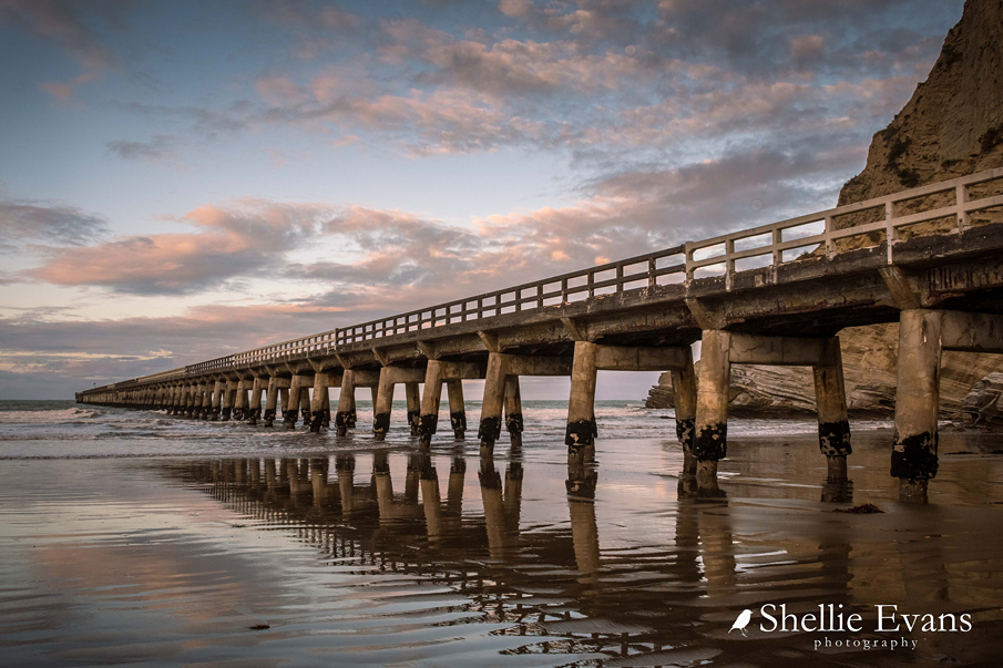
Tolaga Bay Wharf is believed to be the longest reinforced concrete wharf and jetty in an open roadstead in the southern hemisphere and when built it was considered daring to have attempted such a structure in an open dynamic marine situation rather than within a protected harbour. Several technical and design details ensured the structure was sufficiently stable and strong enough to withstand storms and large swells.
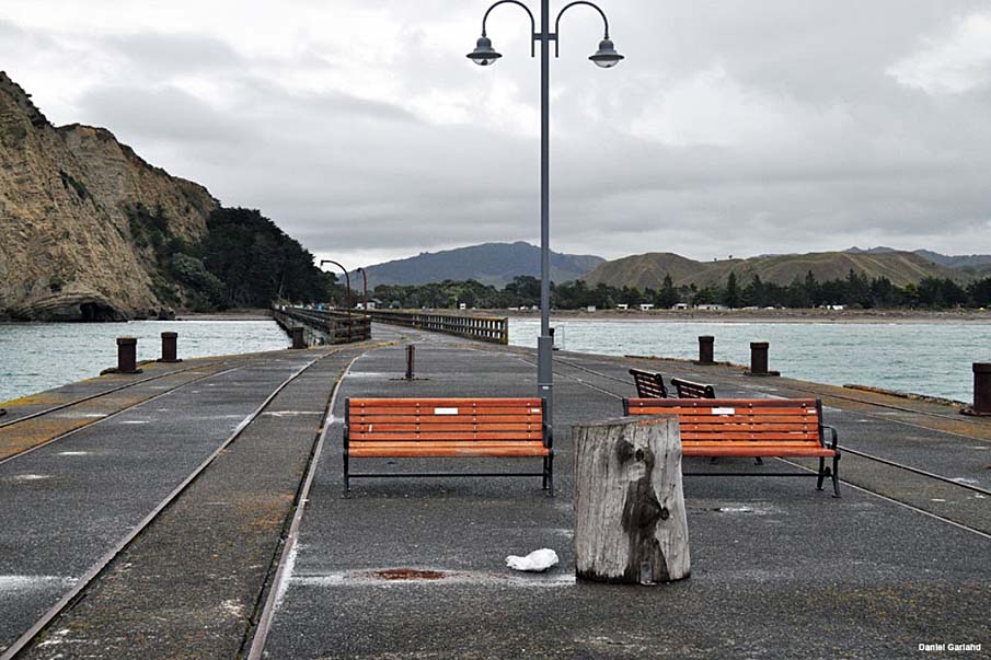
The wharf served the rural community for nearly 40 years as the main route for incoming supplies, machinery, fuel, fertilizer and grain seed and for export of produce such as fattened and store livestock, maize and butter. In this it played a major economic role in the development of the local agricultural industry. After its closure, brought about primarily by the increasingly uneconomic operation after roads were improved and trucks suitable for heavy freight introduced, the wharf continued in use for commercial fishing boats, as a source of kai moana, recreational fishing and other recreational activities. Tolaga Bay Wharf has become a popular tourist attraction because of its length, its stark strong design and its setting.
The wharf has been in poor condition for many years, but since 2001 has been undergoing restoration, a staged process as funding becomes available. Public support for its preservation has been considerable, with additional financial support from the New Zealand Historic Places Trust, the New Zealand Lotteries Board, private benefactors and the Gisborne District Council.
List Entry Information
Status
Listed
List Entry Status
Historic Place Category 1
Access
Able to Visit
List Number
3516
Date Entered
5th April 1984
Date of Effect
5th April 1984
City/District Council
Outside LA Boundaries
Region
Gisborne Region
Extent of List Entry
Extent includes the whole of the structure known as the Tolaga Bay Wharf and its fittings and fixtures, which extends to the north-east from the land parcel described as Pt Sec 1 Blk XII Uawa SD (marked 'A' on SO 8464), Gisborne Land District and across the beach front and into Tolaga Bay (refer to map in Appendix 1 of the review report for further information).
Legal description
Pt Sec 1 Blk XII Uawa SD marked 'A' on SO 8464, (NZ Gazette 1990, p.4033-4), Gisborne Land District.
Location Description
At southeast end of Tolaga Bay foreshore, at north end of Wharf Road
Why is this place significant?
Cultural Significance
Cultural Significance or Value: Local Maori consider the wharf has significance for its association with mahinga kai. It is a popular spot for fishing, crayfishing and shellfishing particularly in the context of large quantities being required for hui. Social Significance or Value: The wharf is significant for its strong association with the production and economic activities of the district. It is a stark memorial to the fervent parochialism of the people of the district that prompted them to establish their own local government body and harbour board. Tolaga Bay Wharf is still used by the community, for social gatherings, fishing and other recreational pursuits. Local people's attachment is reflected in the huge and ambitious initiative to save the wharf from destruction, despite the daunting level of finance needing to be raised. The wharf provided employment during its construction, of major social significance in the years leading up to the Depression of the late 1920s-early 30s. During its use it employed several local people either in permanent roles or as temporary and seasonal workers.
Historic Significance
Historical Significance or Value The wharf reflects a period of East Coast history when most goods and livestock were received or delivered by sea. It represents the needs of the community for an improved facility that could operate regardless of tides and that enabled better, more reliable and more efficient access. The wharf also represents the decline of coastal trading, Tolaga Bay being one of the last strongholds of coastal shipping in the area. It enabled the transporting in to the area of power poles and cable, thus making a notable contribution to the electricity reticulation of the East Coast. The wharf was very important to the development of the agricultural economy locally, regionally and nationally. Its main uses were to load produce from local farms and to ship out livestock, either fattened sheep for the freezing works or fattening in the Waikato or Hawkes Bay. The wharf demonstrates the association of small communities with overseas shipping. Bales of wool were taken by lighter from the wharf to large ocean-going vessels bound for London, cutting costs for local farmers. Tolaga Bay Wharf's construction was undertaken by the Tolaga Bay Harbour Board, a locally-based body formed by the community to solve the difficulties of exporting produce from the district via the earlier inadequate river-based wharf.
Physical Significance
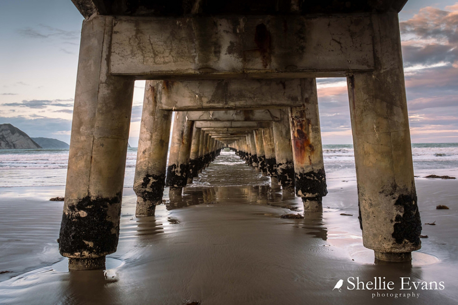
Aesthetic Significance or Value: Stretching more than 600 metres out into open waters, the Tolaga Bay Wharf has a strong and dramatic visual presence. Its linear form, the raking piles and the symmetry of the underlying structure all contributes to its visually satisfying design. Its line stands out in striking contrast to the natural line of its backdrop of pale papa cliffs. It is a stark, hard structure in contrast to the sea around it. Architectural Significance or Value: The wharf's design has been described as daring, with a high element of challenge and risk in its erection in the open sea rather than in the sheltered waters of a harbour. It was designed by a renowned marine engineer, Cyrus J.R. Williams, who undertook major projects in Australia and New Zealand. The design is a representative example of the work being undertaken in wharf development in the 1920s, but with innovative design solutions specific to Tolaga Bay environmental factors. Technological Significance or Value: Tolaga Bay Wharf is significant for the technological solutions made in an attempt to overcome the difficult conditions of its location in the open sea. The diagonal bracing and walings of piles above low-tide level was dispensed with and strength achieved by the bonded and capped raking piles only. The resulting reduction in wave resistance ensured the structure was strong enough to withstand storms. The fendering structure mounted on the sides of the wharf head was an effective design element in protecting the wharf from the shock of impact of the ships berthed beside it being in constant motion. The bollards also had specific design elements to assist with the open roadstead situation. The alignment of the sides of the wharf to be at right angles to the incoming swell was a design element to reduce the physical impact of ships on the wharf structure. Evidence of corrections to the alignment can be seen in that the wharf proper is at a slight angle to the line of the jetty approach. The long approach from the shore along the parapeted jetty to the wharf proper served to control loading operations for livestock with no additional pen structures being required. Perforations in the base of the lowest concrete railing facilitated cleaning of the jetty after stock movements. The wharf is the longest finger-type concrete wharf/jetty in an open roadstead in New Zealand.
Why is this place Category 1 / Category 2?
Detail Of Assessed Criteria
(a) The extent to which the place reflects important or representative aspects of New Zealand history: The Tolaga Bay Wharf reflects the significance of wharves and associated facilities for New Zealand settlements that relied primarily on the sea for transport of freight prior to road and rail networks being established. Tolaga Bay Wharf is strongly indicative of the growth and development of agriculture in New Zealand as Maori land was bought and sub-divided into economic pastoral units. The productivity of the farm units was highly dependent on the supply of fertilizer, equipment and seed and the ability to export the produce such as butter, wool, maize and fattened livestock. Tolaga Bay Wharf is an outstanding and graphic illustration of how such facilities supported the development of the agricultural export industry in the early 20th Century. (b) The association of the place with events, persons, or ideas of importance in New Zealand history: The place is associated with the Tolaga Bay Harbour Board, a community-based body established to solve the difficulties and costs of exporting produce from the district. The wharf was a significant local economic initiative undertaken by a small rural community. (e) The community association with, or public esteem for the place: The Tolaga Bay Wharf was the base for shipping operations for local businesses and farmers, and for older residents of the district it holds strong associations of these activities. It is a frequently-used venue for recreational activities including fishing, walking and sightseeing. It is very popular as a source of kai moana either for line-fishing from the wharf or collecting mussels and crayfish from around the piles. It is a familiar and well-known landmark on the East Coast for locals and visitors and is a nationally-recognised attraction for visitors because of its exceptional length and the outstanding and distinctive scenic value of its setting and design. The wharf is stated to be the most visited and photographed taonga on the East Coast, because of these aesthetic qualities. (g) The technical accomplishment or value, or design of the place: Tolaga Bay Wharf is an outstanding visual design and an example of the design solutions required of engineers and architects for structures in difficult environmental conditions and locations. It has been described as a daring and outstanding engineering achievement, with such a design usually intended for enclosed harbour situations, rather than the open sea. It is the longest concrete jetty and wharf in an open roadstead in New Zealand. (j) The importance of identifying rare types of historic places: The wharf is a rare type of historic place in New Zealand, with only a few of the 11 registered wharves or jetties being the finger type and none being built solely of concrete. It is a rare example of an open roadstead wharf, other New Zealand wharves being finger jetties within enclosed anchorages or breastwork wharves within protected anchorages. (k) The extent to which the place forms part of a wider historical and cultural complex or historical and cultural landscape: The conservation plan for the wharf observed that it was a structure in an area of national coastal heritage significance, based on its close proximity to the 1769 landing place of Captain Cook at Cook's Cove where Banks and Solander collected botanical specimens and accessed wood and fresh water with the blessing of local tangata whenua. Together with sites and structures in Tolaga Bay, Cook's Cove and off-shore islands, the Tolaga Bay Wharf represents one of the wide range of activities associated with the history of the area, with Maori pa, cultivation and urupa sites, Captain Cook's anchorage, the site of the mission station, early European farm buildings and late nineteenth-early twentieth architecture in the town. The wharf is adjacent to, and visible from, the walkway to Cook's Cove. The wharf and walkway are both part of the tourist trail north from Gisborne to East Cape. Summary of Significance or Values: This place was assessed against, and found it to qualify under the following criteria: a, b, e, g, j and k. Conclusion: It is considered that this place qualifies as a Category I historic place. This structure is nationally outstanding and special for: Its rarity value as the longest concrete jetty-wharf in New Zealand in an open roadstead. Technically, the daring design by a nationally renowned engineer who developed specific and innovative solutions to overcome issues with the open roadstead environment in which the wharf was built. It contributed to the development of the New Zealand farming industry and in particular on the East Coast of the North Island, both for provision of essential supplies and export of goods to local and international markets. Aesthetically it is an awe inspiring structure with its length seeming to stretch to the horizon and its hard edged industrial fabric contrasting starkly with its backdrop of white papa cliffs. It has become an iconic visual image that personifies New Zealand's 'clean green' branding and has been included in Tourism New Zealand promotions. Together with sites and structures in Tolaga Bay, Cook's Cove and off-shore islands, Tolaga Bay Wharf represents one of the wide range of activities associated with the early history of the area, with Maori pa, cultivation and urupa sites, Captain Cook's anchorage and the site of a mission station. The wharf is adjacent to, and visible from, the walkway to Cook's Cove, the site where Captain James Cook anchored the Endeavour for repairs and replenishment of supplies on his first visit to New Zealand in 1769.
Why is this place significant?
Cultural Significance
Cultural Significance or Value: Local Maori consider the wharf has significance for its association with mahinga kai. It is a popular spot for fishing, crayfishing and shellfishing particularly in the context of large quantities being required for hui. Social Significance or Value: The wharf is significant for its strong association with the production and economic activities of the district. It is a stark memorial to the fervent parochialism of the people of the district that prompted them to establish their own local government body and harbour board. Tolaga Bay Wharf is still used by the community, for social gatherings, fishing and other recreational pursuits. Local people's attachment is reflected in the huge and ambitious initiative to save the wharf from destruction, despite the daunting level of finance needing to be raised. The wharf provided employment during its construction, of major social significance in the years leading up to the Depression of the late 1920s-early 30s. During its use it employed several local people either in permanent roles or as temporary and seasonal workers.
Historic Significance
Historical Significance or Value The wharf reflects a period of East Coast history when most goods and livestock were received or delivered by sea. It represents the needs of the community for an improved facility that could operate regardless of tides and that enabled better, more reliable and more efficient access. The wharf also represents the decline of coastal trading, Tolaga Bay being one of the last strongholds of coastal shipping in the area. It enabled the transporting in to the area of power poles and cable, thus making a notable contribution to the electricity reticulation of the East Coast. The wharf was very important to the development of the agricultural economy locally, regionally and nationally. Its main uses were to load produce from local farms and to ship out livestock, either fattened sheep for the freezing works or fattening in the Waikato or Hawkes Bay. The wharf demonstrates the association of small communities with overseas shipping. Bales of wool were taken by lighter from the wharf to large ocean-going vessels bound for London, cutting costs for local farmers. Tolaga Bay Wharf's construction was undertaken by the Tolaga Bay Harbour Board, a locally-based body formed by the community to solve the difficulties of exporting produce from the district via the earlier inadequate river-based wharf.
Physical Significance
Aesthetic Significance or Value: Stretching more than 600 metres out into open waters, the Tolaga Bay Wharf has a strong and dramatic visual presence. Its linear form, the raking piles and the symmetry of the underlying structure all contributes to its visually satisfying design. Its line stands out in striking contrast to the natural line of its backdrop of pale papa cliffs. It is a stark, hard structure in contrast to the sea around it. Architectural Significance or Value: The wharf's design has been described as daring, with a high element of challenge and risk in its erection in the open sea rather than in the sheltered waters of a harbour. It was designed by a renowned marine engineer, Cyrus J.R. Williams, who undertook major projects in Australia and New Zealand. The design is a representative example of the work being undertaken in wharf development in the 1920s, but with innovative design solutions specific to Tolaga Bay environmental factors. Technological Significance or Value: Tolaga Bay Wharf is significant for the technological solutions made in an attempt to overcome the difficult conditions of its location in the open sea. The diagonal bracing and walings of piles above low-tide level was dispensed with and strength achieved by the bonded and capped raking piles only. The resulting reduction in wave resistance ensured the structure was strong enough to withstand storms. The fendering structure mounted on the sides of the wharf head was an effective design element in protecting the wharf from the shock of impact of the ships berthed beside it being in constant motion. The bollards also had specific design elements to assist with the open roadstead situation. The alignment of the sides of the wharf to be at right angles to the incoming swell was a design element to reduce the physical impact of ships on the wharf structure. Evidence of corrections to the alignment can be seen in that the wharf proper is at a slight angle to the line of the jetty approach. The long approach from the shore along the parapeted jetty to the wharf proper served to control loading operations for livestock with no additional pen structures being required. Perforations in the base of the lowest concrete railing facilitated cleaning of the jetty after stock movements. The wharf is the longest finger-type concrete wharf/jetty in an open roadstead in New Zealand.
Why is this place Category 1 / Category 2?
Detail Of Assessed Criteria
(a) The extent to which the place reflects important or representative aspects of New Zealand history: The Tolaga Bay Wharf reflects the significance of wharves and associated facilities for New Zealand settlements that relied primarily on the sea for transport of freight prior to road and rail networks being established. Tolaga Bay Wharf is strongly indicative of the growth and development of agriculture in New Zealand as Maori land was bought and sub-divided into economic pastoral units. The productivity of the farm units was highly dependent on the supply of fertilizer, equipment and seed and the ability to export the produce such as butter, wool, maize and fattened livestock. Tolaga Bay Wharf is an outstanding and graphic illustration of how such facilities supported the development of the agricultural export industry in the early 20th Century. (b) The association of the place with events, persons, or ideas of importance in New Zealand history: The place is associated with the Tolaga Bay Harbour Board, a community-based body established to solve the difficulties and costs of exporting produce from the district. The wharf was a significant local economic initiative undertaken by a small rural community. (e) The community association with, or public esteem for the place: The Tolaga Bay Wharf was the base for shipping operations for local businesses and farmers, and for older residents of the district it holds strong associations of these activities. It is a frequently-used venue for recreational activities including fishing, walking and sightseeing. It is very popular as a source of kai moana either for line-fishing from the wharf or collecting mussels and crayfish from around the piles. It is a familiar and well-known landmark on the East Coast for locals and visitors and is a nationally-recognised attraction for visitors because of its exceptional length and the outstanding and distinctive scenic value of its setting and design. The wharf is stated to be the most visited and photographed taonga on the East Coast, because of these aesthetic qualities. (g) The technical accomplishment or value, or design of the place: Tolaga Bay Wharf is an outstanding visual design and an example of the design solutions required of engineers and architects for structures in difficult environmental conditions and locations. It has been described as a daring and outstanding engineering achievement, with such a design usually intended for enclosed harbour situations, rather than the open sea. It is the longest concrete jetty and wharf in an open roadstead in New Zealand. (j) The importance of identifying rare types of historic places: The wharf is a rare type of historic place in New Zealand, with only a few of the 11 registered wharves or jetties being the finger type and none being built solely of concrete. It is a rare example of an open roadstead wharf, other New Zealand wharves being finger jetties within enclosed anchorages or breastwork wharves within protected anchorages. (k) The extent to which the place forms part of a wider historical and cultural complex or historical and cultural landscape: The conservation plan for the wharf observed that it was a structure in an area of national coastal heritage significance, based on its close proximity to the 1769 landing place of Captain Cook at Cook's Cove where Banks and Solander collected botanical specimens and accessed wood and fresh water with the blessing of local tangata whenua. Together with sites and structures in Tolaga Bay, Cook's Cove and off-shore islands, the Tolaga Bay Wharf represents one of the wide range of activities associated with the history of the area, with Maori pa, cultivation and urupa sites, Captain Cook's anchorage, the site of the mission station, early European farm buildings and late nineteenth-early twentieth architecture in the town. The wharf is adjacent to, and visible from, the walkway to Cook's Cove. The wharf and walkway are both part of the tourist trail north from Gisborne to East Cape. Summary of Significance or Values: This place was assessed against, and found it to qualify under the following criteria: a, b, e, g, j and k. Conclusion: It is considered that this place qualifies as a Category I historic place. This structure is nationally outstanding and special for: Its rarity value as the longest concrete jetty-wharf in New Zealand in an open roadstead. Technically, the daring design by a nationally renowned engineer who developed specific and innovative solutions to overcome issues with the open roadstead environment in which the wharf was built. It contributed to the development of the New Zealand farming industry and in particular on the East Coast of the North Island, both for provision of essential supplies and export of goods to local and international markets. Aesthetically it is an awe inspiring structure with its length seeming to stretch to the horizon and its hard edged industrial fabric contrasting starkly with its backdrop of white papa cliffs. It has become an iconic visual image that personifies New Zealand's 'clean green' branding and has been included in Tourism New Zealand promotions. Together with sites and structures in Tolaga Bay, Cook's Cove and off-shore islands, Tolaga Bay Wharf represents one of the wide range of activities associated with the early history of the area, with Maori pa, cultivation and urupa sites, Captain Cook's anchorage and the site of a mission station. The wharf is adjacent to, and visible from, the walkway to Cook's Cove, the site where Captain James Cook anchored the Endeavour for repairs and replenishment of supplies on his first visit to New Zealand in 1769.
Construction Professional
Name
Williams, Cyrus (1862-1942)
Type
Engineer
Biography
Cyrus John Richard Williams (1862-1942) trained as a civil engineer in Queensland, and in December 1902 was appointed engineer to the Lyttelton Harbour Board, at a salary of £500 per annum for a term of three years. He held the position, along with those of Secretary and Treasurer to the Board from 1912, until his retirement in 1927. Williams re-designed the Lyttelton wharf and was in charge of reclamation works there. He was accorded the rank of Member of the Institute of Civil Engineers in 1902. He was president of New Zealand Society of Civil Engineers (now IPENZ) for a one-year term in 1920-21. He was a member of the Nelson Harbour Board and in 1929 he wrote a paper regarding the opening of a new entrance to Nelson Harbour. Williams was one of the construction professionals who worked on the improvements to the Earnscleugh Bridge, Clyde, Central Otago in 1935 (Record no. 2370). As a renowned marine engineer Williams contributed to reports for the Gisborne, Napier and Waikokopu harbours, sat on a panel investigating the collapse of the Western Wharf in Auckland and on Royal Commissions at Foxton and Timaru.
Name
White-Parsons, Gordon
Type
Engineer
Biography
No biography is currently available for this construction professional
Name
Goodman, Frederick
Type
Builder
Biography
English-born Frederick Goodman learnt his trade as a civil engineering contractor working on the four major concrete bridges in Auckland, including the Grafton Bridge and being the foreman of the Mangere Bridge contract, completed in 1915. In 1912-13 he constructed the Orakei sewerage outfall station for Auckland. In 1917 he moved to Gisborne to work on the Mangapoike pumping station. He was responsible for the construction of major structures in Gisborne, including Peel Street Bridge (Record no. 3569), Kaiti Bridge aka Gladstone Road Bridge (Record no. 3534) and the railway bridge (Record no. 3533), plus the middle section of the diversion wall for the harbour in Gisborne. Goodman was also involved in engineering work for the Otago Harbour Board in the early 1930s. He was involved with the construction of the 1935 improvements to the Earnscleugh Bridge in Central Otago (Record no. 2370). Fred Goodman died in 1946 at Napier.
Construction Details
Start Year
1924
Type
Designed
Description
Design and specification produced
Start Year
1926
Type
Original Construction
Description
Construction began by April
Start Year
1929
Type
Original Construction
Description
Construction completed in November
Start Year
1963
Type
Other
Description
July, storm damage
Start Year
1967
Type
Other
Description
Wharf closed to shipping
Start Year
1971
Type
Modification
Description
Erection of gate at abutments
Start Year
1977
Type
Other
Description
Wharf closed to vehicles
Start Year
1989
Type
Other
Description
26 May, storm damage, loss of ladders and damage at expansion joint
Start Year
2000
startYearCirca
Type
Modification
Description
Removal of telephone poles and cables
Start Year
2001
Finish Year
2002
Type
Modification
Description
Sept 2001 - May 2002. Phase 1 restoration of first 15 bents
Start Year
2005
Finish Year
2006
Type
Other
Description
Mar 2005 - mid 2006. Phase 2 of the restoration
Start Year
2006
Type
Modification
Description
September 2006 two ladders replaced
Construction Materials
Reinforced concrete Australian ironbark and turpentine timber fittings Iron rail tracks
Tolaga Bay Wharf was built over a three-year period from 1926 to 1929 by the Tolaga Bay Harbour Board to provide an improved facility for the import and export of materials, produce and livestock for the district. A wharf had existed in the Uawa River at Tolaga Bay since the turn of the twentieth century, but as this was inaccessible to larger craft, freight haulage was dependent on lighters, which were in turn dependent on tides, weather conditions and the degree of silt deposition. Tolaga Bay is a U-shaped bay 2.4 kilometres wide, open to the northeast and protected by high cliffs on the north and south. Storms come in from the east, making the southwest corner of the bay the most protected. The Uawa River flows into the bay approximately mid-way along the sandy shore. From around the turn of the fifteenth century Te Aitanga-a-Hauiti, Ngati Porou, became the dominant iwi and was in occupation at the time of first European contact. Maori utilised the flat land as well as the slopes around the bay and the off-shore islands; archaeological sites recorded include pa, pits, terraces, midden, burials, wild taro and cultivated soils. Tolaga Bay first became known to Europeans when it was visited by Captain James Cook between 23 and 29 October 1769 when the Endeavour anchored in Cook's Cove for cleaning, repairs, and fresh supplies of wood, water and food. In the early nineteenth century flax traders established posts in the bay. From the 1820s the paramountcy of Te Kani Takirau was established; his large defended pa at the mouth of the Uawa River was associated with extensive cultivations of traditional and introduced crops. A mission station was established by the pa in 1843, by which time there was a small settlement of Europeans. In March 1875 when the government bought 252 acres (102 hectares) as the site of a proposed township, Tolaga Bay had the largest European-style settlement on the East Coast with 52 European residents. Tolaga Bay was part of Cook County when it was formed in 1876. The first roads into the district were inadequate for wheeled traffic and for several long stretches they utilised the beaches. The first coach service from Gisborne to Tolaga Bay started in 1887. The main access was by sea and wharves were built at Tokomaru Bay, Hick's Bay and Port Awaroa and a larger wharf with port facilities at Gisborne. At Tolaga Bay, the small jetties on the north side of the Uawa River were superseded by a wharf. the Hauiti wharf, on the south side. Materials and produce were brought in or shipped out by a lightering service, the Tolaga Bay Lightering Company. As the fertile country was opened up, pastoral farming developed, such that by 1900 wool was a major export. In 1912 the Tolaga Bay dairy factory opened. The town of Tolaga Bay continued to develop with a smaller settlement, Hauiti, on the south side of the Uawa River. On 28 July 1908 the Governor in Council constituted the Tolaga Bay Harbour District and at the same time appointed the Cook County Council, which was based in Gisborne, to be the Harbour Board. While the Hauiti wharf allowed easier handling of freight, there was still a strong dependence on tides, the weather and the state of the river which was prone to silting up. A large shed for storing and dumping wool was built close to the wharf. Towards the end of 1913 residents began pushing for a better wharf situated outside the river. A drastic series of thirteen floods in the twelve months from May 1916 exacerbated the silting problem. After the First World War the government established returned soldiers on dairy farms of 50-80 acres (20-32 hectares). As whole milk could not be exported, pig farming also developed, using the skim milk as feed. Butter made from the cream was a growing export. In 1919 a strong sense of parochialism drove the Tolaga Bay community to form its own harbour board. The Tolaga Bay Harbour Act 1919 established the Harbour District to be that of the Uawa County Council. The first general meeting of the Tolaga Bay Harbour Board was held on 17 March 1920. The Board was composed of five elected nominees and two Government nominees. Edward Brabazon Boland was elected to the chair. At this first meeting, it was decided to approach the Minister of Marine to recommend a suitable engineer to report on required harbour works. Design and construction: In April 1920 the Tolaga Bay Harbour Board appointed Cyrus J.R. Williams, the engineer to the Lyttelton Harbour Board, as consultant engineer for the purpose of investigating and designing a wharf for the bay, with 18 feet (5.5 metres) of water at low tide. In his design for the Tolaga Bay Wharf, Williams considered the direction of swell as well as the depth at low water, utilising a survey undertaken by Captain Martin and William Lockwood in June 1920. Williams's first design proposal, submitted in July 1920, was for a pier 1500 feet (457.2m) long with an additional wharf 400 feet (121.92m) long, however a special meeting of ratepayers and the Board on 21 August 1920 agreed to a smaller wharf. Legislation was required to enable the Harbour Board to borrow in order to finance such an expensive project. The Tolaga Bay Harbour Board Empowering Act was passed on 22 December 1921 to authorize the Board to raise a loan of £100,000 with the proviso that a poll of ratepayers be taken to seek their approval. The Act allowed the Board to charge an additional levy on ratepayers. On 17 October 1923 the Board approved the design for a 1400 feet (426.72m) long jetty with a 200 feet (60.96m) long 'pier head', extending out from the foot of the south cliff, access to it being via a road 900 (274.32m) feet long with tunnels cut into the cliff. At the same meeting the Board appointed Cyrus Williams Consulting Engineer for the purpose of harbour works proposed by the Board. After several changes the design was approved by the Governor-General by 21 June 1924. This design took the wharf into 18 foot 6 inches (5.66m) of water at low water spring tides. The Board advertised for tenders for its construction and on 13 November 1924 accepted Gisborne contractor Fred Goodman's tender of £60,331. The specification was for the construction of the road and the wharf. Williams appointed Gordon White-Parsons as Resident Engineer and Inspector of Works at a salary of £400 per annum, this being approved by the Harbour Board to begin from 1 January 1925. Work began on the road but several instances of falling rock gave concern. After visits on 12 March 1925 and 11 August 1925 Williams admitted he had over-estimated the stability of the rock and agreed to make alterations to the location of the wharf and consequently its design. The amended designs were prepared by October. It appears the work began on the existing structure early in 1926, with Goodman requesting permission to begin the abutments at the shore end of the jetty in April 1926. Cyrus Williams visited the site in October 1926 and approved the slight deviations from the specification, which included a change in the rake of the piles, saying that he was 'perfectly satisfied' with the work. Up to 26 men were employed on the construction; it is believed they were mostly brought in from elsewhere. Some locals assisted, including two local teenagers who cleaned the reinforcing steel with sugar bags. The men stayed in a camp set up near the wharf. The foreman was Tom Crombie. Temporary work sheds were also built near the end of the wharf. The project provided work during the beginning of the Great Depression. The first twelve pairs of piles, where the jetty crossed the beach above the low tide mark, were cast in situ into pre-drilled holes and wooden boxing. The piles were octagonal in cross-section with steel reinforcing rods. The headstocks were then cast onto the tops of the piles utilising reinforcing rods extending out from the piles plus additional rods. The concrete deck was cast in situ. The shingle for the work was brought by ships from Napier, 'which in itself was no small undertaking'. Once this first section was completed it served as a work platform for the rest of the construction. The rest of the piles were cast horizontally on the deck or on the beach and were circular in cross-section, but flat on the underside; the pouring gap along the top also resulted in a flat surface. Once set, they were hauled into position by winches attached to the gantry built at the seaward end of the jetty. The holes for the piles were drilled by means of a jumper type drill operated by steam friction winches. The gear was adapted from a discarded set of oil-well drilling gear. The first 12 pairs of piles are splayed (raked) but because of difficulties of drilling into the mudstone substrate, the angle of the majority of piles is close to vertical. Damage to piles resulted in delays and the £70,000 loan was spent well before completion of the project. Some damage was the result of three tidal waves that hit the end of the wharf in quick succession, shifting the gantry, washing away loose timber and fracturing five piles that had not been secured. Early in February 1927 two piles, at bays 55 and 62, were pushed out of position and fractured during a storm. Cyrus Williams visited in June 1927 and 21 December 1927 to inspect the damage then present amendments to the plan, including alterations to the alignment of the piles and for the introduction of an expansion joint at bay 55. On 5 May 1928 he gave a verbal report on the damage done to the piles and stated 'that there was no cause for alarm'. Further changes were requested by Goodman: for rapid setting cement, an additional cost of £300, and a change to the shape of the bollards. By 7 July 1928 the Gisborne Sheepfarmers Frozen Meat and Mercantile Company Limited had agreed to sell to the Harbour Board their dump plant and other equipment at the Uawa River wharf and over the next year the wharf shed was demolished and re-built by Goodman's team at the new wharf. The 'large and commodious' cargo shed was built so that on one side lorries could unload onto four-foot (1.2 metre) high platforms at the three wide doorways; on the other side a lower platform was provided for loading onto railway wagons. The rail tracks, which were at the base of the hill, i.e. the south side of the shed, led onto the jetty. The shed held equipment for 'dumping' of wool bales. By 1 September 1928 the Board were planning on engaging staff. Captain J.M. Fraser, master mariner, was appointed harbourmaster. Opening of the wharf: On Friday, 22 November 1929 the Tolaga Bay Wharf and facilities were opened by the Minister of Marine the Hon. J.G. Cobbe, the ribbon-cutting being undertaken by elderly resident Mrs Margaret 'Granny' Lockwood. Speakers included the Minister, the Chairman of the Harbour Board and Sir Apirana Ngata. Other official visitors included Member of Parliament K.S. Williams, the Chairmen of the Gisborne and Tokomaru Bay Harbour Boards, the Gisborne manager of the Union Steam Ship Company, the manager of Napier shipping firm the Richardson Company, the engineers and contractor, members of the county council and other local bodies. A large crowd attended the festivities, for which the cargo shed and a temporary archway over the entrance to the jetty were decorated with flags and bunting and 'an occasion of considerable importance in the history of the coast was fittingly marked'. Two vessels berthed at the wharf, the Awahou and the Tiroa, also flew their flags. After the official ceremony the Tolaga Bay Harbour Board members hosted the official visitors to a luncheon. Mr F.J. Williams, the chairman of the Tokomaru Bay Harbour Board, said that the comparatively small community 'had shown commendable pluck and foresight in undertaking this work'. The wharf provided employment to several local men, with at least three permanent staff who included a harbourmaster and a wharf hand, and several casual (and seasonal) 'seagulls', mostly Maori, who unloaded wool out from the dumping shed and unloaded the coastal ships and lighters at the wharf. At its peak in 1936, 133 ships worked at the port. These were primarily motor vessels owned by the Gisborne Sheepfarmers' Frozen Meat and Mercantile Company and Richardson and Company Ltd, each of which was absorbed by the Union Steam Ship Company but continued to operate under their own names. The Gisborne Sheepfarmers' ships included the Margaret W and Turihaua. The Tiroa carried general cargo from Auckland to Tokomaru and Tolaga Bays. Richardsons' vessels included the Gunbar, the Kopara (specially built for the coastal service), the Koutunui, the Pukeko and the Pateke. On 22 August 1936 the Pukeko struck the wharf at Tolaga Bay. During the Second World War some of the coastal traders, such as the Kopara, were requisitioned for war service and were therefore not servicing Tolaga Bay; the waterfront strike of 1951 also affected the viability of sea-based freight. Improvements to roads and the development of trucks capable of carrying heavier loads enabled larger carrying capacity on land and it became cheaper and easier to shift both goods and livestock by road, especially for the relatively short distance (56 kilometres) to Gisborne. The shingle for the roads was brought in over the Tolaga Bay Wharf. Other factors in the decline of the shipping service were the packaging of materials such as gasoline, diesel and cement in bulk containers or purpose-built vehicles. In 1957 only 15 ships worked the Tolaga Bay Wharf. Reports comparing freight costs to Gisborne or Napier from Tolaga Bay by sea versus by road showed it was cheaper and easier to shift to road transport. In 1955 and 1958 shipments of hardwood power poles and cross-arm timber came in over the wharf, during electricity reticulation of the East Coast rural districts. The timber was brought by the Union Company's ship direct from New South Wales. The Tolaga Bay Harbour Board was dissolved on 30 September 1961 and the functions of the Board were vested in the Uawa County Council. At the final meeting of the Board the then chairman, Arthur Donald, was hopeful that 'even allowing for the decline in tonnage of cargo handled, under careful supervision and prudent management the services hitherto provided should be able to be maintained'. At that stage the Gisborne Sheepfarmers' Company's lease of part of the shed for a binning room had been renewed for five years. However just two years later, in 1963, the Uawa County Council decided to close the south side of the wharf as berthage, as the cost of repairs for the damage to the fender piles that had occurred earlier in July were considered prohibitive. Repairs to the northern side were to be carried out as these would cost much less and this was the side favoured by the larger coastal vessels. Concern was also expressed at the time regarding the condition of some of the piles and of the wharf shed. In November 1963 MV Pukeko and MV Pateke loaded wool from the wharf, the Pukeko's load being destined for London via Wellington. However, by this time maize was being taken out by road in preference. The £100,000 loan was completely repaid by September 1963. From 1st April 1964 the Uawa County Council was amalgamated with the Cook County Council, whereby the Cook County Council became the controlling authority for the Tolaga Bay Wharf. By the end of 1965 the situation for coastal shipping had deteriorated further and in 1966 Richardsons sold the Kopara, a decision that 'marked the end of the line for ... the ports of Hicks Bay, Tokomaru Bay and Tolaga Bay'. The wharf was closed to cargo in 1966 but the wharf shed continued to dump wool. However this service saw a downturn in the 1966-67 year, possibly due to Richardson and Co. discontinuing their coastal shipping service and farmers thinking the dumping service had also stopped. Tolaga Bay Wharf was closed to shipping in 1967. In March 1968 one railway wagon was picked up by the New Zealand Locomotive Society as a museum item. By 1968 the wharf was used solely by a local commercial fisherman to offload his vessel; from 30 April 1968 he used the shed for storage, and in 1971 erected a gate across the end of the wharf. His lease was terminated in September 1973. In 1973 Council made an inventory of remaining equipment in the shed with a view to its disposal. At a meeting on 8 November 1976 the council concluded that it saw no future for the use of the wharf, based on its finger type, its proximity to Gisborne, the exposed nature of the bay, its distance to the main state forestry areas and the apparent deteriorated condition of the existing structure. Although the county engineer considered that structurally the wharf would last for some time, the council closed the wharf to vehicular traffic for safety reasons. The Buildings Classification Committee of the New Zealand Historic Places Trust visited the wharf between 9 and 12 March 1984 and the wharf was subsequently given a C Classification. In the late 1980s the amalgamation of counties saw the formation of Gisborne District Council which inherited all assets from Cook County Council, including the Tolaga Bay Wharf. Ladders, erected as a safety measure for people to get out of the water, were a maintenance problem, and were to be re-erected in late 1985. On 26 May 1989 a storm damaged the wharf, including the demolition and loss of the ladders and at mid-length 'a subsidence of approximately 50mm over the expansion joint... An underside inspection showed the pile cap and pile hinging.' The Council's Engineering Officer recommended warning signs for pedestrians and further restricting vehicular access by placing boulders at the entrance to the wharf. In February 1991 the wharf shed and a small amount of surrounding land was sold and the remaining part of the Harbour Board's land was re-scheduled as road reserve. In c.1995 the Ministry of Agriculture and Fisheries asked the Gisborne District Council to issue a demolition order for the wharf. In May 1996 a public meeting resolved that the wharf was worth saving, and decided to support any efforts the council made for its restoration. A committee of local people was formed to further these aims. By May 1997 the committee had raised over $12,000 towards a feasibility study of restoring the wharf. In 1999 the Tolaga Bay Save The Wharf Charitable Trust was established. Fundraising efforts included flea markets, beach races and the Chef Quarter Marathon. As supportive measures the Hauiti Corporation re-opened the Cook's Cove walkway and planned the upgrade of the adjacent motor camp. In 1997 the Gisborne District Council commissioned a conservation plan for the wharf and wharf sheds. The structural report by Barry Potter of Worley Consultants noted that the concrete below the deck was in 'very poor condition with extensive spalling and general degradation' and found that this was 'so extensive that there is no economic or practical method of restoring the wharf to its original condition or structural capacity to support imposed loads'. The telephone cables and poles on the wharf were casualties of theft and storm damage respectively, and had gone by c.2000. On 5 April 2000 Gisborne District Council agreed in principle to endorse the option of preservation. Reconstruction: A phased restoration project was suggested, partly due to the cost. The first phase was to work on the first 13 bents (a bent comprising a pair of piles and the headstock between). These were in the worst condition because there was no circumferential reinforcing, and as the concrete and steel is not continually wet the salts forming around the steel have a chance to concentrate, expand and break the concrete. In Phase 1 of the restoration, all the concrete in the piles was removed and replaced. The contractors for this work were Conspec of Tauranga with sub-contractors Coastal Maintenance New Zealand Limited. Phase 1 began in early September 2001 and was completed in May 2002 at a cost of nearly $300,000. For Phase 2 of the restoration, consulting engineer John Reynolds of Opus, designed a concrete jacket to fit around each pile. Phase 2, to replace bents 15 to 56, began in March 2005. Concure Australia and Gisborne concreting contractors B.H. Ritchie and Sons were contracted to undertake the work. The major earthquake that occurred in 20 December 2007 caused only a few cracks but no major damage. In May 2008 tenders were called for the next stage of restoration, which will use a new technology. Recognition of the wharf's importance as a heritage item, and of the affection with which it is held, has been evident in the financial support the restoration project has received. Donations have come from the Gisborne Branch Committee of the New Zealand Historic Places Trust, the Ministry of Tourism and Sport, local trusts, businesses and clubs and from public collection boxes. The New Zealand Lotteries Board has recognised the importance of the wharf with major contributions towards its restoration. Media support has been considerable. The wharf has featured on New Zealand Tourism Board posters distributed around the world and is a major drawcard for tourists. It is touted as 'the most visited and photographed taonga (treasure) on the East Coast'. The New Zealand Lotteries Board has included it in advertising campaigns. The wharf is much-photographed because of its aesthetic qualities such as its strong visual presence in the landscape, its tremendous length (660m), its linear form, the raking piles and the symmetry of the underlying structure. The wharf is a focal point for recreation, with local people and others from the wider area including Gisborne coming to the wharf for fishing from it, or for picnics. Local Maori value it as a mahinga kai for gathering kai moana, particularly mussels from the piers and crayfish which hide in the debris (including the fenders) at the base of the wharf end. The wharf contributes towards the well-being of the community, as reported by resident Kori Kirikiri in 1997: '... if we lose this, we are going to lose our pride'. The wharf stands 'as a monument to the halcyon days of the great pastoral economy'. Architectural historian Geoffrey Thornton has said 'without doubt, it is the best such example in the history of our minor ports, especially one where 'lightering' took place for overseas vessels anchored in the roadstead'. Thornton believes it to be the longest finger-type wharf in New Zealand, irrespective of the material with which it is constructed. A 1944 description felt that Williams's 'rather daring project... deserves recognition as an outstanding harbour engineering achievement in the design of open-roadstead jetties'. This view is supported by engineer Graham Tayler: 'what makes the wharf unique in my mind is that it was built in the open sea. This not only increased the challenge and risk in building it, but was also a risk ... [with] ... the loading and offloading a ship that was in constant motion in a way that would not damage the ship or the wharf...'. Tolaga Bay Wharf is regarded as one of the 'great East Coast icons'. Thornton has referred to the wharf as 'a striking monument with its tremendous length paralleling the nearby cliffs' and finds it 'visually a satisfying design with its raking piles and balustrades of concrete posts with rails of the same material'.
Tolaga Bay Wharf was built over a three-year period from 1926 to 1929 by the Tolaga Bay Harbour Board to provide an improved facility for the import and export of materials, produce and livestock for the district. A wharf had existed in the Uawa River at Tolaga Bay since the turn of the twentieth century, but as this was inaccessible to larger craft, freight haulage was dependent on lighters, which were in turn dependent on tides, weather conditions and the degree of silt deposition. Tolaga Bay is a U-shaped bay 2.4 kilometres wide, open to the northeast and protected by high cliffs on the north and south. Storms come in from the east, making the southwest corner of the bay the most protected. The Uawa River flows into the bay approximately mid-way along the sandy shore. From around the turn of the fifteenth century Te Aitanga-a-Hauiti, Ngati Porou, became the dominant iwi and was in occupation at the time of first European contact. Maori utilised the flat land as well as the slopes around the bay and the off-shore islands; archaeological sites recorded include pa, pits, terraces, midden, burials, wild taro and cultivated soils. Tolaga Bay first became known to Europeans when it was visited by Captain James Cook between 23 and 29 October 1769 when the Endeavour anchored in Cook's Cove for cleaning, repairs, and fresh supplies of wood, water and food. In the early nineteenth century flax traders established posts in the bay. From the 1820s the paramountcy of Te Kani Takirau was established; his large defended pa at the mouth of the Uawa River was associated with extensive cultivations of traditional and introduced crops. A mission station was established by the pa in 1843, by which time there was a small settlement of Europeans. In March 1875 when the government bought 252 acres (102 hectares) as the site of a proposed township, Tolaga Bay had the largest European-style settlement on the East Coast with 52 European residents. Tolaga Bay was part of Cook County when it was formed in 1876. The first roads into the district were inadequate for wheeled traffic and for several long stretches they utilised the beaches. The first coach service from Gisborne to Tolaga Bay started in 1887. The main access was by sea and wharves were built at Tokomaru Bay, Hick's Bay and Port Awaroa and a larger wharf with port facilities at Gisborne. At Tolaga Bay, the small jetties on the north side of the Uawa River were superseded by a wharf. the Hauiti wharf, on the south side. Materials and produce were brought in or shipped out by a lightering service, the Tolaga Bay Lightering Company. As the fertile country was opened up, pastoral farming developed, such that by 1900 wool was a major export. In 1912 the Tolaga Bay dairy factory opened. The town of Tolaga Bay continued to develop with a smaller settlement, Hauiti, on the south side of the Uawa River. On 28 July 1908 the Governor in Council constituted the Tolaga Bay Harbour District and at the same time appointed the Cook County Council, which was based in Gisborne, to be the Harbour Board. While the Hauiti wharf allowed easier handling of freight, there was still a strong dependence on tides, the weather and the state of the river which was prone to silting up. A large shed for storing and dumping wool was built close to the wharf. Towards the end of 1913 residents began pushing for a better wharf situated outside the river. A drastic series of thirteen floods in the twelve months from May 1916 exacerbated the silting problem. After the First World War the government established returned soldiers on dairy farms of 50-80 acres (20-32 hectares). As whole milk could not be exported, pig farming also developed, using the skim milk as feed. Butter made from the cream was a growing export. In 1919 a strong sense of parochialism drove the Tolaga Bay community to form its own harbour board. The Tolaga Bay Harbour Act 1919 established the Harbour District to be that of the Uawa County Council. The first general meeting of the Tolaga Bay Harbour Board was held on 17 March 1920. The Board was composed of five elected nominees and two Government nominees. Edward Brabazon Boland was elected to the chair. At this first meeting, it was decided to approach the Minister of Marine to recommend a suitable engineer to report on required harbour works. Design and construction: In April 1920 the Tolaga Bay Harbour Board appointed Cyrus J.R. Williams, the engineer to the Lyttelton Harbour Board, as consultant engineer for the purpose of investigating and designing a wharf for the bay, with 18 feet (5.5 metres) of water at low tide. In his design for the Tolaga Bay Wharf, Williams considered the direction of swell as well as the depth at low water, utilising a survey undertaken by Captain Martin and William Lockwood in June 1920. Williams's first design proposal, submitted in July 1920, was for a pier 1500 feet (457.2m) long with an additional wharf 400 feet (121.92m) long, however a special meeting of ratepayers and the Board on 21 August 1920 agreed to a smaller wharf. Legislation was required to enable the Harbour Board to borrow in order to finance such an expensive project. The Tolaga Bay Harbour Board Empowering Act was passed on 22 December 1921 to authorize the Board to raise a loan of £100,000 with the proviso that a poll of ratepayers be taken to seek their approval. The Act allowed the Board to charge an additional levy on ratepayers. On 17 October 1923 the Board approved the design for a 1400 feet (426.72m) long jetty with a 200 feet (60.96m) long 'pier head', extending out from the foot of the south cliff, access to it being via a road 900 (274.32m) feet long with tunnels cut into the cliff. At the same meeting the Board appointed Cyrus Williams Consulting Engineer for the purpose of harbour works proposed by the Board. After several changes the design was approved by the Governor-General by 21 June 1924. This design took the wharf into 18 foot 6 inches (5.66m) of water at low water spring tides. The Board advertised for tenders for its construction and on 13 November 1924 accepted Gisborne contractor Fred Goodman's tender of £60,331. The specification was for the construction of the road and the wharf. Williams appointed Gordon White-Parsons as Resident Engineer and Inspector of Works at a salary of £400 per annum, this being approved by the Harbour Board to begin from 1 January 1925. Work began on the road but several instances of falling rock gave concern. After visits on 12 March 1925 and 11 August 1925 Williams admitted he had over-estimated the stability of the rock and agreed to make alterations to the location of the wharf and consequently its design. The amended designs were prepared by October. It appears the work began on the existing structure early in 1926, with Goodman requesting permission to begin the abutments at the shore end of the jetty in April 1926. Cyrus Williams visited the site in October 1926 and approved the slight deviations from the specification, which included a change in the rake of the piles, saying that he was 'perfectly satisfied' with the work. Up to 26 men were employed on the construction; it is believed they were mostly brought in from elsewhere. Some locals assisted, including two local teenagers who cleaned the reinforcing steel with sugar bags. The men stayed in a camp set up near the wharf. The foreman was Tom Crombie. Temporary work sheds were also built near the end of the wharf. The project provided work during the beginning of the Great Depression. The first twelve pairs of piles, where the jetty crossed the beach above the low tide mark, were cast in situ into pre-drilled holes and wooden boxing. The piles were octagonal in cross-section with steel reinforcing rods. The headstocks were then cast onto the tops of the piles utilising reinforcing rods extending out from the piles plus additional rods. The concrete deck was cast in situ. The shingle for the work was brought by ships from Napier, 'which in itself was no small undertaking'. Once this first section was completed it served as a work platform for the rest of the construction. The rest of the piles were cast horizontally on the deck or on the beach and were circular in cross-section, but flat on the underside; the pouring gap along the top also resulted in a flat surface. Once set, they were hauled into position by winches attached to the gantry built at the seaward end of the jetty. The holes for the piles were drilled by means of a jumper type drill operated by steam friction winches. The gear was adapted from a discarded set of oil-well drilling gear. The first 12 pairs of piles are splayed (raked) but because of difficulties of drilling into the mudstone substrate, the angle of the majority of piles is close to vertical. Damage to piles resulted in delays and the £70,000 loan was spent well before completion of the project. Some damage was the result of three tidal waves that hit the end of the wharf in quick succession, shifting the gantry, washing away loose timber and fracturing five piles that had not been secured. Early in February 1927 two piles, at bays 55 and 62, were pushed out of position and fractured during a storm. Cyrus Williams visited in June 1927 and 21 December 1927 to inspect the damage then present amendments to the plan, including alterations to the alignment of the piles and for the introduction of an expansion joint at bay 55. On 5 May 1928 he gave a verbal report on the damage done to the piles and stated 'that there was no cause for alarm'. Further changes were requested by Goodman: for rapid setting cement, an additional cost of £300, and a change to the shape of the bollards. By 7 July 1928 the Gisborne Sheepfarmers Frozen Meat and Mercantile Company Limited had agreed to sell to the Harbour Board their dump plant and other equipment at the Uawa River wharf and over the next year the wharf shed was demolished and re-built by Goodman's team at the new wharf. The 'large and commodious' cargo shed was built so that on one side lorries could unload onto four-foot (1.2 metre) high platforms at the three wide doorways; on the other side a lower platform was provided for loading onto railway wagons. The rail tracks, which were at the base of the hill, i.e. the south side of the shed, led onto the jetty. The shed held equipment for 'dumping' of wool bales. By 1 September 1928 the Board were planning on engaging staff. Captain J.M. Fraser, master mariner, was appointed harbourmaster. Opening of the wharf: On Friday, 22 November 1929 the Tolaga Bay Wharf and facilities were opened by the Minister of Marine the Hon. J.G. Cobbe, the ribbon-cutting being undertaken by elderly resident Mrs Margaret 'Granny' Lockwood. Speakers included the Minister, the Chairman of the Harbour Board and Sir Apirana Ngata. Other official visitors included Member of Parliament K.S. Williams, the Chairmen of the Gisborne and Tokomaru Bay Harbour Boards, the Gisborne manager of the Union Steam Ship Company, the manager of Napier shipping firm the Richardson Company, the engineers and contractor, members of the county council and other local bodies. A large crowd attended the festivities, for which the cargo shed and a temporary archway over the entrance to the jetty were decorated with flags and bunting and 'an occasion of considerable importance in the history of the coast was fittingly marked'. Two vessels berthed at the wharf, the Awahou and the Tiroa, also flew their flags. After the official ceremony the Tolaga Bay Harbour Board members hosted the official visitors to a luncheon. Mr F.J. Williams, the chairman of the Tokomaru Bay Harbour Board, said that the comparatively small community 'had shown commendable pluck and foresight in undertaking this work'. The wharf provided employment to several local men, with at least three permanent staff who included a harbourmaster and a wharf hand, and several casual (and seasonal) 'seagulls', mostly Maori, who unloaded wool out from the dumping shed and unloaded the coastal ships and lighters at the wharf. At its peak in 1936, 133 ships worked at the port. These were primarily motor vessels owned by the Gisborne Sheepfarmers' Frozen Meat and Mercantile Company and Richardson and Company Ltd, each of which was absorbed by the Union Steam Ship Company but continued to operate under their own names. The Gisborne Sheepfarmers' ships included the Margaret W and Turihaua. The Tiroa carried general cargo from Auckland to Tokomaru and Tolaga Bays. Richardsons' vessels included the Gunbar, the Kopara (specially built for the coastal service), the Koutunui, the Pukeko and the Pateke. On 22 August 1936 the Pukeko struck the wharf at Tolaga Bay. During the Second World War some of the coastal traders, such as the Kopara, were requisitioned for war service and were therefore not servicing Tolaga Bay; the waterfront strike of 1951 also affected the viability of sea-based freight. Improvements to roads and the development of trucks capable of carrying heavier loads enabled larger carrying capacity on land and it became cheaper and easier to shift both goods and livestock by road, especially for the relatively short distance (56 kilometres) to Gisborne. The shingle for the roads was brought in over the Tolaga Bay Wharf. Other factors in the decline of the shipping service were the packaging of materials such as gasoline, diesel and cement in bulk containers or purpose-built vehicles. In 1957 only 15 ships worked the Tolaga Bay Wharf. Reports comparing freight costs to Gisborne or Napier from Tolaga Bay by sea versus by road showed it was cheaper and easier to shift to road transport. In 1955 and 1958 shipments of hardwood power poles and cross-arm timber came in over the wharf, during electricity reticulation of the East Coast rural districts. The timber was brought by the Union Company's ship direct from New South Wales. The Tolaga Bay Harbour Board was dissolved on 30 September 1961 and the functions of the Board were vested in the Uawa County Council. At the final meeting of the Board the then chairman, Arthur Donald, was hopeful that 'even allowing for the decline in tonnage of cargo handled, under careful supervision and prudent management the services hitherto provided should be able to be maintained'. At that stage the Gisborne Sheepfarmers' Company's lease of part of the shed for a binning room had been renewed for five years. However just two years later, in 1963, the Uawa County Council decided to close the south side of the wharf as berthage, as the cost of repairs for the damage to the fender piles that had occurred earlier in July were considered prohibitive. Repairs to the northern side were to be carried out as these would cost much less and this was the side favoured by the larger coastal vessels. Concern was also expressed at the time regarding the condition of some of the piles and of the wharf shed. In November 1963 MV Pukeko and MV Pateke loaded wool from the wharf, the Pukeko's load being destined for London via Wellington. However, by this time maize was being taken out by road in preference. The £100,000 loan was completely repaid by September 1963. From 1st April 1964 the Uawa County Council was amalgamated with the Cook County Council, whereby the Cook County Council became the controlling authority for the Tolaga Bay Wharf. By the end of 1965 the situation for coastal shipping had deteriorated further and in 1966 Richardsons sold the Kopara, a decision that 'marked the end of the line for ... the ports of Hicks Bay, Tokomaru Bay and Tolaga Bay'. The wharf was closed to cargo in 1966 but the wharf shed continued to dump wool. However this service saw a downturn in the 1966-67 year, possibly due to Richardson and Co. discontinuing their coastal shipping service and farmers thinking the dumping service had also stopped. Tolaga Bay Wharf was closed to shipping in 1967. In March 1968 one railway wagon was picked up by the New Zealand Locomotive Society as a museum item. By 1968 the wharf was used solely by a local commercial fisherman to offload his vessel; from 30 April 1968 he used the shed for storage, and in 1971 erected a gate across the end of the wharf. His lease was terminated in September 1973. In 1973 Council made an inventory of remaining equipment in the shed with a view to its disposal. At a meeting on 8 November 1976 the council concluded that it saw no future for the use of the wharf, based on its finger type, its proximity to Gisborne, the exposed nature of the bay, its distance to the main state forestry areas and the apparent deteriorated condition of the existing structure. Although the county engineer considered that structurally the wharf would last for some time, the council closed the wharf to vehicular traffic for safety reasons. The Buildings Classification Committee of the New Zealand Historic Places Trust visited the wharf between 9 and 12 March 1984 and the wharf was subsequently given a C Classification. In the late 1980s the amalgamation of counties saw the formation of Gisborne District Council which inherited all assets from Cook County Council, including the Tolaga Bay Wharf. Ladders, erected as a safety measure for people to get out of the water, were a maintenance problem, and were to be re-erected in late 1985. On 26 May 1989 a storm damaged the wharf, including the demolition and loss of the ladders and at mid-length 'a subsidence of approximately 50mm over the expansion joint... An underside inspection showed the pile cap and pile hinging.' The Council's Engineering Officer recommended warning signs for pedestrians and further restricting vehicular access by placing boulders at the entrance to the wharf. In February 1991 the wharf shed and a small amount of surrounding land was sold and the remaining part of the Harbour Board's land was re-scheduled as road reserve. In c.1995 the Ministry of Agriculture and Fisheries asked the Gisborne District Council to issue a demolition order for the wharf. In May 1996 a public meeting resolved that the wharf was worth saving, and decided to support any efforts the council made for its restoration. A committee of local people was formed to further these aims. By May 1997 the committee had raised over $12,000 towards a feasibility study of restoring the wharf. In 1999 the Tolaga Bay Save The Wharf Charitable Trust was established. Fundraising efforts included flea markets, beach races and the Chef Quarter Marathon. As supportive measures the Hauiti Corporation re-opened the Cook's Cove walkway and planned the upgrade of the adjacent motor camp. In 1997 the Gisborne District Council commissioned a conservation plan for the wharf and wharf sheds. The structural report by Barry Potter of Worley Consultants noted that the concrete below the deck was in 'very poor condition with extensive spalling and general degradation' and found that this was 'so extensive that there is no economic or practical method of restoring the wharf to its original condition or structural capacity to support imposed loads'. The telephone cables and poles on the wharf were casualties of theft and storm damage respectively, and had gone by c.2000. On 5 April 2000 Gisborne District Council agreed in principle to endorse the option of preservation. Reconstruction: A phased restoration project was suggested, partly due to the cost. The first phase was to work on the first 13 bents (a bent comprising a pair of piles and the headstock between). These were in the worst condition because there was no circumferential reinforcing, and as the concrete and steel is not continually wet the salts forming around the steel have a chance to concentrate, expand and break the concrete. In Phase 1 of the restoration, all the concrete in the piles was removed and replaced. The contractors for this work were Conspec of Tauranga with sub-contractors Coastal Maintenance New Zealand Limited. Phase 1 began in early September 2001 and was completed in May 2002 at a cost of nearly $300,000. For Phase 2 of the restoration, consulting engineer John Reynolds of Opus, designed a concrete jacket to fit around each pile. Phase 2, to replace bents 15 to 56, began in March 2005. Concure Australia and Gisborne concreting contractors B.H. Ritchie and Sons were contracted to undertake the work. The major earthquake that occurred in 20 December 2007 caused only a few cracks but no major damage. In May 2008 tenders were called for the next stage of restoration, which will use a new technology. Recognition of the wharf's importance as a heritage item, and of the affection with which it is held, has been evident in the financial support the restoration project has received. Donations have come from the Gisborne Branch Committee of the New Zealand Historic Places Trust, the Ministry of Tourism and Sport, local trusts, businesses and clubs and from public collection boxes. The New Zealand Lotteries Board has recognised the importance of the wharf with major contributions towards its restoration. Media support has been considerable. The wharf has featured on New Zealand Tourism Board posters distributed around the world and is a major drawcard for tourists. It is touted as 'the most visited and photographed taonga (treasure) on the East Coast'. The New Zealand Lotteries Board has included it in advertising campaigns. The wharf is much-photographed because of its aesthetic qualities such as its strong visual presence in the landscape, its tremendous length (660m), its linear form, the raking piles and the symmetry of the underlying structure. The wharf is a focal point for recreation, with local people and others from the wider area including Gisborne coming to the wharf for fishing from it, or for picnics. Local Maori value it as a mahinga kai for gathering kai moana, particularly mussels from the piers and crayfish which hide in the debris (including the fenders) at the base of the wharf end. The wharf contributes towards the well-being of the community, as reported by resident Kori Kirikiri in 1997: '... if we lose this, we are going to lose our pride'. The wharf stands 'as a monument to the halcyon days of the great pastoral economy'. Architectural historian Geoffrey Thornton has said 'without doubt, it is the best such example in the history of our minor ports, especially one where 'lightering' took place for overseas vessels anchored in the roadstead'. Thornton believes it to be the longest finger-type wharf in New Zealand, irrespective of the material with which it is constructed. A 1944 description felt that Williams's 'rather daring project... deserves recognition as an outstanding harbour engineering achievement in the design of open-roadstead jetties'. This view is supported by engineer Graham Tayler: 'what makes the wharf unique in my mind is that it was built in the open sea. This not only increased the challenge and risk in building it, but was also a risk ... [with] ... the loading and offloading a ship that was in constant motion in a way that would not damage the ship or the wharf...'. Tolaga Bay Wharf is regarded as one of the 'great East Coast icons'. Thornton has referred to the wharf as 'a striking monument with its tremendous length paralleling the nearby cliffs' and finds it 'visually a satisfying design with its raking piles and balustrades of concrete posts with rails of the same material'.
Construction Professionals: Designer and engineer: 1923-29 Cyrus J.R. Williams Resident engineer (project supervisor): 1926-29 Gordon White-Parsons Builder: 1925-29 Frederick Goodman Restoration engineers: John Reynolds Graham Tayler, Gisborne District Council Restoration contractors: Conspec Construction Concure Australia Ltd Coastal Maintenance New Zealand Limited The structure consists of an approach jetty or pier, with the wider working wharf at its extremity. The jetty section is aligned approximately nor-nor-east with the wharf section aligned more to the northeast. The 2,000 feet (609.6 metres) approach is a reinforced concrete deck 17 feet (5.18 metres) wide with a reinforced concrete railing or balustrade. The deck is supported on caps and beams on pairs of raking piles at 20 feet (6.09 metres) centres, the deck surface being about 11 feet (3.35 metres) above high water of spring tides, or 17 feet (5.18 metres) above low water of spring tides. There is an expansion joint at 1,100 feet (335 metres) from shore, and the railing has joints at 100 feet (30.5 metres) intervals. At the outer end, over a distance of 80 feet (24.4 metres) the jetty widens out to the wharf proper, being 52 feet (15.84 metres) wide and 200 feet (60.96 metres) long. Over this length the pile spacing of 20 feet (6.09 metres) is maintained. The caps are supported on four plumb piles and stiffened by two raking piles. Across the outer end of the wharf four extra 'rakers' are driven as additional resistance against breaking seas. The depth of water at the wharf is 18 feet (5.48 metres) at low water of spring tides. A pair of railway lines begins on the south side of the concrete pad on which stood the wharf shed, with a small siding. The rails extend the length of the jetty but on the wharf proper they split twice such that two pairs of lines are set into the deck on each of the south and the north sides. The rails extend beyond the traverser well, but one pair is incomplete. The traverser well is a recessed rectangular area with rails aligned across the wharf. Along the north and south edges of the wharf proper, are wooden kerbs made of Australian ironwood. Turpentine was used for its resistance to the very active Teredo worm. At the end of the wharf are five concrete buffers, the remnants of what were four pairs of buffers each pair with a wooden cross-member. The bolts remain protruding from the ledge on which the beams were mounted (see photographs, Appendix 3). Other minor fittings and fixtures include two pairs of poles for suspending lifeboats, on the southern side near the junction with the jetty. These are of different styles and are in differing states of completeness and deterioration. In the floor of the traverser well is a heavy metal eye (ring) with two others at the end of the wharf. On the piles restored in Phase 2 of the restoration project, the cylindrical concrete jacket does not extend to the seabed and the narrower original piles are visible at low tide. An additional non-original fixed feature is a concrete block at the entrance to the wharf, set there to prevent vehicle access. In 2008 a concrete pole with a solar-powered detector and counter was erected close to the wharf to provide accurate numbers of visitors to the wharf.
Construction Professionals: Designer and engineer: 1923-29 Cyrus J.R. Williams Resident engineer (project supervisor): 1926-29 Gordon White-Parsons Builder: 1925-29 Frederick Goodman Restoration engineers: John Reynolds Graham Tayler, Gisborne District Council Restoration contractors: Conspec Construction Concure Australia Ltd Coastal Maintenance New Zealand Limited The structure consists of an approach jetty or pier, with the wider working wharf at its extremity. The jetty section is aligned approximately nor-nor-east with the wharf section aligned more to the northeast. The 2,000 feet (609.6 metres) approach is a reinforced concrete deck 17 feet (5.18 metres) wide with a reinforced concrete railing or balustrade. The deck is supported on caps and beams on pairs of raking piles at 20 feet (6.09 metres) centres, the deck surface being about 11 feet (3.35 metres) above high water of spring tides, or 17 feet (5.18 metres) above low water of spring tides. There is an expansion joint at 1,100 feet (335 metres) from shore, and the railing has joints at 100 feet (30.5 metres) intervals. At the outer end, over a distance of 80 feet (24.4 metres) the jetty widens out to the wharf proper, being 52 feet (15.84 metres) wide and 200 feet (60.96 metres) long. Over this length the pile spacing of 20 feet (6.09 metres) is maintained. The caps are supported on four plumb piles and stiffened by two raking piles. Across the outer end of the wharf four extra 'rakers' are driven as additional resistance against breaking seas. The depth of water at the wharf is 18 feet (5.48 metres) at low water of spring tides. A pair of railway lines begins on the south side of the concrete pad on which stood the wharf shed, with a small siding. The rails extend the length of the jetty but on the wharf proper they split twice such that two pairs of lines are set into the deck on each of the south and the north sides. The rails extend beyond the traverser well, but one pair is incomplete. The traverser well is a recessed rectangular area with rails aligned across the wharf. Along the north and south edges of the wharf proper, are wooden kerbs made of Australian ironwood. Turpentine was used for its resistance to the very active Teredo worm. At the end of the wharf are five concrete buffers, the remnants of what were four pairs of buffers each pair with a wooden cross-member. The bolts remain protruding from the ledge on which the beams were mounted (see photographs, Appendix 3). Other minor fittings and fixtures include two pairs of poles for suspending lifeboats, on the southern side near the junction with the jetty. These are of different styles and are in differing states of completeness and deterioration. In the floor of the traverser well is a heavy metal eye (ring) with two others at the end of the wharf. On the piles restored in Phase 2 of the restoration project, the cylindrical concrete jacket does not extend to the seabed and the narrower original piles are visible at low tide. An additional non-original fixed feature is a concrete block at the entrance to the wharf, set there to prevent vehicle access. In 2008 a concrete pole with a solar-powered detector and counter was erected close to the wharf to provide accurate numbers of visitors to the wharf.
Historical and Associated Iwi / Hapū / Whānau
Completion Date
26th February 2009
Report Written By
Lynette Williams
Information Sources
Auckland Weekly News
Auckland Weekly News
Dominion
Dominion, 16 Jul 1915, p. 9.
Furkert, 1953
Frederick William Furkert, Early New Zealand Engineers, Wellington, 1953
Gisborne Herald
14 Dec 2012
Laurie, 1991
John Laurie, Tolaga Bay: A History of the Uawa District, H.B. Williams Memorial Library, Gisborne, 1991.
McGill, 1997
David McGill and Grant Sheehan, Landmarks: Notable Historic Buildings of New Zealand, Auckland, 1997
New Zealand Gazette
New Zealand Gazette
Poverty Bay Herald
Poverty Bay Herald
Ross, 1977
John Ross, Pride in Their Ports: The Story of the Minor Ports. Dunmore Press, Palmerston North, 1977
Thornton, 1996
Geoffrey Thornton, Cast in Concrete: Concrete Construction in New Zealand 1850-1939, Auckland, 1996
Gisborne Times
Gisborne Times
Hawera & Normanby Star
Hawera & Normanby Star, 22 May 1915, p.1;
Journal of the Institute of Civil Engineers
Journal of the Institute of Civil Engineers
Donald, 2003
Sam Donald, (G.L.A.) and Stephen Donald, Many Roads from Hauiti: a Tolaga Bay Memoir, Rakopu Press, Gisborne, 2003
Farquahar, 2001
Ian Farquahar, Union Fleet, New Zealand Ship and Marine Society, Wellington, 2001
Gundry, 2004
Sheridan Gundry, Making a killing; a history of the Gisborne-East Coast freezing works industry, Tairawhiti Museum, Gisborne, 2004
Jennings, 2003
Murray Jennings, The Era of Coastal Shipping in New Zealand; the small motor ships, Transpress, Wellington, N.Z., 2003.
McLean, 1989
Gavin McLean, Richardsons of Napier, New Zealand Ship and Marine Society, Wellington, 1989
Woods, 1998
John Woods, Highway 35; travels around East Cape, Reed, Auckland, 1998
Conservation Plan
Conservation Plan
Other Information
This place is part of a Road Reserve. (NZ Gazette 181422.1, 13 November 1990, NZ Gazette 25 October 1990 p.4033) A fully referenced Registration report is available from the NZHPT Lower Northern Area Office Please note that entry on the New Zealand Heritage List/Rarangi Korero identifies only the heritage values of the property concerned, and should not be construed as advice on the state of the property, or as a comment of its soundness or safety, including in regard to earthquake risk, safety in the event of fire, or insanitary conditions.
Current Usages
Uses: Civic Facilities
Specific Usage: Civic facilities - other
Uses: Civic Facilities
Specific Usage: Recreation Area/Picnic Ground
Uses: Cultural Landscape
Specific Usage: Historic Landscape
Uses: Maori
Specific Usage: Mahinga kai - food, forest and mineral resource site
Uses: Maori
Specific Usage: Tauranga ika - fishing ground and associated landscape features
Uses: Transport
Specific Usage: Footpath/Path/track
Former Usages
General Usage: Transport
Specific Usage: Wharf/Dock/ Pier/ Jetty
Themes
Of Significance to Maori
Web Links
description: IPENZ Engineering Heritage
url: http://www.ipenz.org.nz/heritage/itemdetail.cfm?itemid=186
Location
Sign up to hear more
Get the latest heritage news, features and events delivered
straight to your inbox.
