

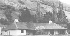
In a remote situation near the headwaters of the south Branch of the Hurunui River lies the original Esk Head homestead built in 1863 of cob. It is a rare survival of an early runholder's cottage continuously occupied as the homestead and with virtually no alterations. The replacement was not built until 1984.
The cob building was erected by Christopher Edward Dampier who had taken up the run in 1859 after coming to New Zealand as solicitor for the Canterbury Association nine years earlier. The station has remained in the family for 122 years until a recent change of ownership. The Family did not live at Esk Head but several managers have occupied the homestead throughout most of this period. In the high country area where extremes of temperature are experienced the cob construction, 500mm thick, provides very good insulation as does the thatch of snow grass fully exposed in the kitchen and verandas. At some stage corrugated iron had been placed over the thatch.
Of single storey the house is L shaped with verandas on the re-entrant sides and wide eaves. In addition to the cob some of the construction is of rammed earth (pis'e de terre) and some of the partitions are wattle and daub.
Hugging the ground in a narrow valley the cosy Esk Head homestead has considerable aesthetic appeal. As an example of early unaltered cob homestead construction it is the finest in New Zealand.
List Entry Information
Status
Listed
List Entry Status
Historic Place Category 1
Access
Private/No Public Access
List Number
3675
Date Entered
27th June 1985
Date of Effect
27th June 1985
City/District Council
Hurunui District
Region
Canterbury Region
Extent of List Entry
Extent of registration includes part of the land described as RS 34647 (RT CB22K/502), Canterbury Land District, and the building known as Esk Head Station Homestead (Former) thereon, as shown on SO 412228.
Legal description
RS 34647 (RT CB22K/502), Canterbury Land District
Location Description
The homestead is located adjacent to Esk Head Road near the headwaters of the Hurunui River South Branch, approximately 3.2 kilometres west of where Esk Head Road joins with Lake Sumner Road.
Status
Listed
List Entry Status
Historic Place Category 1
Access
Private/No Public Access
List Number
3675
Date Entered
27th June 1985
Date of Effect
27th June 1985
City/District Council
Hurunui District
Region
Canterbury Region
Extent of List Entry
Extent of registration includes part of the land described as RS 34647 (RT CB22K/502), Canterbury Land District, and the building known as Esk Head Station Homestead (Former) thereon, as shown on SO 412228.
Legal description
RS 34647 (RT CB22K/502), Canterbury Land District
Location Description
The homestead is located adjacent to Esk Head Road near the headwaters of the Hurunui River South Branch, approximately 3.2 kilometres west of where Esk Head Road joins with Lake Sumner Road.
Construction Details
Start Year
1863
Type
Original Construction
Construction Details
Start Year
1863
Type
Original Construction
Historical and Associated Iwi / Hapū / Whānau
Other Information
This place was identified as significant under previous legislation with different information requirements. It remains significant under the current legislation. There is opportunity under our legislation and policies to add to this information. Further information about this place may be available from the Southern Regional Office of Heritage New Zealand Pouhere Taonga. Please note that entry on the New Zealand Heritage List/Rarangi Korero identifies only the heritage values of the property concerned, and should not be construed as advice on the state of the property, or as a comment of its soundness or safety, including in regard to earthquake risk, safety in the event of fire, or insanitary conditions. This historic place was registered under the Historic Places Act 1980. The following text is the original citation considered by the NZHPT Board at the time of registration. Information in square brackets indicate modifications made after the paper was considered by the NZHPT Board.
Historical and Associated Iwi / Hapū / Whānau
Other Information
This place was identified as significant under previous legislation with different information requirements. It remains significant under the current legislation. There is opportunity under our legislation and policies to add to this information. Further information about this place may be available from the Southern Regional Office of Heritage New Zealand Pouhere Taonga. Please note that entry on the New Zealand Heritage List/Rarangi Korero identifies only the heritage values of the property concerned, and should not be construed as advice on the state of the property, or as a comment of its soundness or safety, including in regard to earthquake risk, safety in the event of fire, or insanitary conditions. This historic place was registered under the Historic Places Act 1980. The following text is the original citation considered by the NZHPT Board at the time of registration. Information in square brackets indicate modifications made after the paper was considered by the NZHPT Board.
Former Usages
General Usage: Accommodation
Specific Usage: House
Former Usages
General Usage: Accommodation
Specific Usage: House
Sign up to hear more
Get the latest heritage news, features and events delivered
straight to your inbox.
