

Farming at Wiwaka Station has occurred since the land was cleared in the late 1880s. The family that subsequently owned the land first leased it, and the farm grew gradually over the years. A sawmill called Bright and Bacon operated on the site from 1888, and the Wiwaka Station Woolshed was constructed in 1889. Timber milling was a major source of income in the early years of the settlement and matai, rimu and totara were felled from the immediate area. A lease for the land at Wiwaka was arranged with F.C.Turnor who was a prominent butcher in Eketahuna at the time. The first lease was for 14 years, and was then owned by Turnor and his subsequent family, who have farmed the area ever since. Turnor is noted for having been the mayor of Eketahuna from 1912-19.
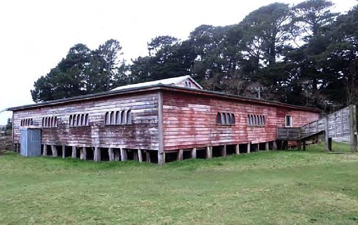
Within its pastoral setting, Wiwaka Station Woolshed provides considerable aesthetic significance. The rounded windows on the exterior are a point of difference, as are the massive hand-adzed totara piles on which the woolshed rests. The Woolshed offers a romantic view of late nineteenth century New Zealand pastoralism, and is attractive with its faded red façade, reminiscent of other farm buildings clad in the same red oxide paint. While it is unlikely that the woolshed was designed by an architect, it follows a form which is essentially interchangeable between early woolsheds, following the form of the land and the need of the farmer, dependent on the number of sheep being shorn in the time in which it was constructed.
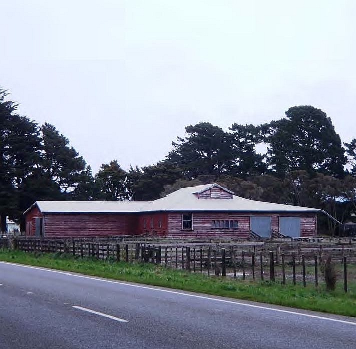
Wiwaka Station Woolshed is situated next to State Highway 2 and is a place that is highly visible on the approach to Eketahuna. In this place it provides evidence of early settlement of the area and is a standing representation of early European settlement there. Wiwaka Station Woolshed reflects important aspects of New Zealand’s pastoral history, and reflects the success of early settlers in developing farms and farmland from small beginnings, and the importance of sheep farming in the Tararua region.
List Entry Information
Status
Listed
List Entry Status
Historic Place Category 2
Access
Private/No Public Access
List Number
3970
Date Entered
23rd June 2011
Date of Effect
23rd June 2011
City/District Council
Tararua District
Region
Horizons (Manawatū-Whanganui) Region
Extent of List Entry
Extent includes part of the land described as Pt Sec 2B BLK X Mangaone SD (RT WN100/98), Wellington Land District and the building known as Wiwaka Station Woolshed thereon, and its fittings and fixtures, and its associated yards. (Refer to map in Appendix 1 of the registration report for further information).
Legal description
Pt Sec 2B BLK X Mangaone SD (RT WN100/98), Wellington Land District
Location Description
When travelling south from Eketahuna along State Highway 2, Wiwaka Station is approximately 3 kilometres from the town on the western side of the road. The woolshed is easily seen from the road.
Why is this place significant?
Cultural Significance
Social Significance or Value: Wiwaka Station Woolshed has played a part in employment of individuals for shearing purposes over its 120 year history. Woolsheds were not simply places for work and gangs of shearers who were employed over seasons would live in the area surrounding them, forming an important part of the social history of an area. Shearing was an integral part of the lives of many people in the region whose livelihoods depended on the work available at stations during shearing season. These people may have left no more permanent mark than, for example, the graffiti in Wiwaka Station Woolshed.
Historic Significance
Historical Significance or Value Wiwaka Station Woolshed is part of the wider history of the Eketahuna area, where large sheep farms form an important part of its general history. The woolshed was constructed from pitsawn totara which was sawn on the property, from a sawmill which is no longer extant, but which forms an important part of the history of the area. The original owner of the property went on to become the mayor of Eketahuna and was an important part of the early life of the town through his work on the County Council as their chairman. Wiwaka Station Woolshed reflects important aspects of New Zealand’s pastoral history, for example as an area that was cleared of native bush and gradually changed over time into a farm. During the 1850s, the development of large scale pastoralism took place in the Wairarapa and Tararua regions. Extensive colonisation of the Tararua area occurred as it was recognised that the region was useful for sheep farming. Farming is an integral part of both the history and current life of the region, and Wiwaka Station Woolshed is a representative part of this history. The Woolshed reflects the success of early settlers in developing farms and farmland from small beginnings, and the importance of sheep farming in the Tararua region.
Physical Significance
Aesthetic Significance or Value: Within its pastoral setting, Wiwaka Station Woolshed provides considerable aesthetic significance. Wiwaka Station Woolshed is situated next to State Highway 2 and is a place that is highly visible on the approach to Eketahuna. The rounded windows on the exterior are a point of difference, as are the hand-adzed totara piles on which the woolshed rests. The Woolshed offers a romantic view of late nineteenth century New Zealand pastoralism, and is attractive with its faded red façade, reminiscent of other farm buildings clad in the same red oxide paint.
Why is this place Category 1 / Category 2?
Detail Of Assessed Criteria
(a) The extent to which the place reflects important or representative aspects of New Zealand history Wiwaka Station Woolshed is representative of the tenacity of individuals living in rural New Zealand, and also of the development of pastoralism in New Zealand. The Woolshed is an important part of the history of the area surrounding Eketahuna and its development. It reflects important aspects of New Zealand’s pastoral history, for example as an area that was cleared of native bush and gradually changed over time into a farm. The Wiwaka Station Woolshed reflects the success of early settlers in developing farms and farmland from small beginnings, and shows the determination of the European settlers to remain permanently in an inhospitable area. (g) The technical accomplishment or value, or design of the place While it is unlikely that the woolshed was designed by an architect, it follows a form which is essentially interchangeable between early woolsheds, following the form of the land and the need of the farmer, dependent on the number of sheep being shorn in the time in which it was constructed. The woolshed sits on massive hand-adzed totara piles and has survived earthquakes and fire in the region. The rounded windows on the exterior are a point of design difference, as is the low pitch of the roof of the woolshed. Summary of Significance or Values This place was assessed against, and found to qualify under the following criteria: a, g. Conclusion It is considered that this place qualifies as a Category II historic place.
Construction Details
Start Year
1889
Type
Original Construction
Description
Woolshed thought to have been constructed
Start Year
1940
Type
Addition
Description
Race thought to have been added to the south side of the building
Construction Materials
Timber, glass, corrugated iron
Construction Details
Start Year
1889
Type
Original Construction
Description
Woolshed thought to have been constructed
Start Year
1940
Type
Addition
Description
Race thought to have been added to the south side of the building
Construction Materials
Timber, glass, corrugated iron
The discovery and settlement of the Wairarapa and Tararua regions are connected with several prominent figures in New Zealand’s history. Ancestral figures such as Hau-nui-a-nanaia, Kupe, Whatonga, Tara Ika and Toi have all been said to have connections with the region and are responsible for the naming of many of the Wairarapa’s features and places. It has been estimated that Rangitane settled in the region by about the sixteenth century. Marriage links with Rangitane saw a group of Ngati Kahungunu retreat to the Wairarapa in the subsequent century as the result of internal hapu conflict. The two groups cohabitated mostly in the south Wairarapa for a period, but then the Ngati Kahungunu newcomers negotiated several sections of land for themselves. This process was not seamless and instances of conflict continued between the two iwi over the centuries. The next significant period of change in the area was in the early nineteenth century with the progression south of Te Rauparaha and others. This ushered in an era when many different iwi, including Ngati Whatua, Ngati Awa, Ngati Toa, Ngati Raukawa, Ngati Tama, and Ngati Mutunga, made advances into the region and some Ngati Kahungunu hapu withdrew. While the Wairarapa was sparsely settled during initial Maori occupation, it has been suggested that by the time European settlement occurred large amounts of the region had already been cleared of the ‘primordial’ forest referred to by Colenso on his later incursion there. The northern Wairarapa was heavily forested, as opposed to the south with its relatively clear and large grass plains. In particular the forest north of Otawhao/Mount Bruce was dense with rimu, tawa, matai, maire, kahikatea, and rata, and was known as Forty Mile Bush, which Eketahuna is part of, which was within the larger Seventy Mile Bush. Maori referred to this forest as Te Tapere Nui o Whatonga (The great forest of Whatonga) and an abundance of birdlife resided there amongst giant ancient trees, some of which were large enough for groups of people to shelter within their trunks. European incursion into the Wairarapa and Tararua only began after the New Zealand Company’s Port Nicholson settlement was established. The southern Wairarapa became one of the first extensive tracts of land to be occupied by Europeans, although the Crown titles, negotiated by Donald McLean, were not obtained until 1853. Squatting, and leasing, of land was a major inhibitor to the sale of land in the Wairarapa. The forest acted as a significant barrier and while there was some European settlement in the northern Wairarapa before the late nineteenth century, it was not until roads were extended further, and the railway link to Wellington established, that the area was opened up for substantive settlement. The Scandinavian (and German) migration to the Southern Wairarapa had been made possible through Julius Vogel’s (1835-1899) 1870 Immigration and Public Works Act. In 1871 the government began especially recruiting Scandinavians to come to New Zealand, because they were seen as particularly useful for work on the early phases of railway and road construction, and were contracted to build roads and fell the forest surrounding the area. Towns such as Eketahuna were initially formed as bases for the railway labourers. Part of the preparation for the railway construction included building a road through the district which had progressed by the mid to late 1870s, as had the initial development of the settlements at Mauriceville and Eketahuna. Eketahuna means ‘to run aground on a sandbank,’ meaning that canoes could proceed no further down the Makakahi River. The town was briefly renamed Mellemskov (translated as Heart of the Forest) by the Scandanavian settlers who founded the town, before it reverted to its original name. The majority of the first settlers to Eketahuna were Swedish, and arrived on the Forfarshire in Wellington on 4 March 1873. The new arrivals had a period of rest in Wellington, then travelled over the Rimutaka hills to a camp at Kopuaranga. This was their place of residence for seven months, as Eketahuna was yet to be surveyed. Peter Best writes that after a few months around 13 people made their way from Kopuaranga to Waiwaka where they found a disused surveyor’s hut which they made weatherproof, and used until they had completed the road to the settlement of Eketahuna. Eketahuna grew quickly and was linked with Wellington when the railway reached the town on the 8th of April 1889, and the town became a borough in 1907. Wiwaka Station is around three kilometres south of Eketahuna. The locality is known as Waiwaka. The words Waiwaka and Wiwaka are a misspelling of Wi Waaka, who was a Ngati Hamua chief that had cultivations and kainga in the area. Te Waiwaka was the last papakainga before moving into Te Kauru, the upper Ruamahanga valley. There was also a Maori track through Eketahuna and Waiwaka which lead through the district. The area around Wiwaka Station was a 1000 acre Maori Reserve. Adcock notes that there was difficulty in securing land in the area in 1873 because the boundaries of this reserve had not been surveyed. Farming at Wiwaka Station has occurred since the land was cleared in the late 1880s. A sawmill called Bright and Bacon operated on the site from 1888. Timber milling was a major source of income in the early years of the settlement and matai, rimu and totara were felled from the immediate area. Best suggests that the timber used for Government Building in Lambton Quay, Wellington, came from Eketahuna. The station woolshed was constructed in 1889. A lease for the land at Wiwaka was arranged for F.C.Turnor who was a prominent butcher in Eketahuna at the time. The first lease was for 14 years, and was then owned by Turnor and his subsequent family, who have farmed the area ever since. Turnor is also notable for being the mayor of Eketahuna from 1912-19, and Bagnall writes that under his service many improvements were brought to Eketahuna, including a new water scheme. He had already served on the County Council and been its chairman for a number of years. He gained his experience in farming in Kansas. His son, Percy, was killed in action on 27 August 1915 and is buried at Gallipoli. Tragically, Percy had been injured in Egypt and could have been invalided home, instead opting to continue fighting. Turnor’s term as mayor encompassed World War One and the subsequent influenza epidemic, and the councillors noted ‘the prompt action taken by him in combating the recent influenza epidemic and the establishment of the temporary hospital.’ While fires in the region were commonplace during the turn of the century, in 1908 there was a devastating fire in the district surrounding Eketahuna, caused by the particularly dry summer of 1907-8. Fires began in the middle of January that could have been contained save a heavy wind that developed and fanned fires in the district. Eketahuna was not the only town to suffer, with some reports stating that the whole district was ablaze by the 21st of January. Fires continued until the end of the month. While the fire had a major impact on the built heritage of the towns in the district, it also had a major impact on their futures and economy. Timber production, which prior to this was the district’s main source of income, fell into decline and after the fire pastoral farming became the main occupation there. The Poverty Bay Herald notes that a large area of grass was burnt at Waiwaka, although it is unclear whether this led to the subsequent demise of the sawmill there. Certainly other sawmills in the region were burnt in this fire. Similarly, there were several earthquakes felt in the region during its settlement, for example the 1855 and 1942 earthquakes. The Wiwaka Station Woolshed survived some of these disasters. Sheep farming and pastoralism in the Tararua region While it has been suggested that there are no known records of Europeans in the Wairarapa prior to 1840, extensive colonisation of the area occurred as it was recognised that the region was useful for sheep farming. Sheep farming for wool and later meat is the agricultural industry for which New Zealand is best known. During the 1850s, the development of large scale pastoralism took place in the region. The Wairarapa and Tararua regions were among the first areas extensively settled for farming purposes, and farming is an integral part of both the history and current life of the region. Because of the prominence of sheep farming, woolsheds are amongst New Zealand’s most characteristic farm buildings. It was here that sheep were sorted and held prior to shearing. Shearing and the sorting, baling and storage of wool were all carried out in woolsheds. Until the 1890s shearing was carried out by hand, until the introduction in 1899 of mechanical shears, and later in the 20th century electrically powered shears. Woolsheds typically follow the form that had already gained popularity in Australia, with three basic areas: the pens for holding sheep, the shearing board where the sheep were shorn and the wool room where fleeces were sorted classed and pressed into bales. They were often raised above the ground to allow cleaning out below the slated floors. Kernohan writes that ‘notwithstanding the work of JS Swan, few, if any woolsheds were designed by architects … most were designed and built by farmer and labourer to formulaic patterns adjusted to local topography, siting, materials and circumstances’ This appears to have been the case at Wiwaka, which is of a fairly standard layout. Woolsheds vary in size from relatively small structures to those with as many as 48 stands. Wiwaka is therefore a relatively small woolshed, with three stands. Woolsheds were not simply places for work and gangs of shearers who were employed over seasons would live in the area surrounding them, forming an important part of the social history of an area. Shearing was an integral part of the lives of many people in the region whose livelihoods depended on the work available at stations during shearing season, and remains an important part of the lives of many people in rural New Zealand today. These people may have left no more permanent mark than, for example, the graffiti in Wiwaka Station Woolshed. On describing the Wiwaka Station Woolshed historian Geoffrey Thornton states that: ‘it commands considerable interest from passers by because of the unusual fenestration: the windows are in banks of six or more panes with the glass sloping inwards towards the rounded heads.’ The woolshed also features a very low pitch roof - ‘certainly not the normal practice at that period.’ There are also interesting features such as the hand-adzed totara piles that the building sits seemingly precariously on. The Woolshed remains in use in 2010.
The discovery and settlement of the Wairarapa and Tararua regions are connected with several prominent figures in New Zealand’s history. Ancestral figures such as Hau-nui-a-nanaia, Kupe, Whatonga, Tara Ika and Toi have all been said to have connections with the region and are responsible for the naming of many of the Wairarapa’s features and places. It has been estimated that Rangitane settled in the region by about the sixteenth century. Marriage links with Rangitane saw a group of Ngati Kahungunu retreat to the Wairarapa in the subsequent century as the result of internal hapu conflict. The two groups cohabitated mostly in the south Wairarapa for a period, but then the Ngati Kahungunu newcomers negotiated several sections of land for themselves. This process was not seamless and instances of conflict continued between the two iwi over the centuries. The next significant period of change in the area was in the early nineteenth century with the progression south of Te Rauparaha and others. This ushered in an era when many different iwi, including Ngati Whatua, Ngati Awa, Ngati Toa, Ngati Raukawa, Ngati Tama, and Ngati Mutunga, made advances into the region and some Ngati Kahungunu hapu withdrew. While the Wairarapa was sparsely settled during initial Maori occupation, it has been suggested that by the time European settlement occurred large amounts of the region had already been cleared of the ‘primordial’ forest referred to by Colenso on his later incursion there. The northern Wairarapa was heavily forested, as opposed to the south with its relatively clear and large grass plains. In particular the forest north of Otawhao/Mount Bruce was dense with rimu, tawa, matai, maire, kahikatea, and rata, and was known as Forty Mile Bush, which Eketahuna is part of, which was within the larger Seventy Mile Bush. Maori referred to this forest as Te Tapere Nui o Whatonga (The great forest of Whatonga) and an abundance of birdlife resided there amongst giant ancient trees, some of which were large enough for groups of people to shelter within their trunks. European incursion into the Wairarapa and Tararua only began after the New Zealand Company’s Port Nicholson settlement was established. The southern Wairarapa became one of the first extensive tracts of land to be occupied by Europeans, although the Crown titles, negotiated by Donald McLean, were not obtained until 1853. Squatting, and leasing, of land was a major inhibitor to the sale of land in the Wairarapa. The forest acted as a significant barrier and while there was some European settlement in the northern Wairarapa before the late nineteenth century, it was not until roads were extended further, and the railway link to Wellington established, that the area was opened up for substantive settlement. The Scandinavian (and German) migration to the Southern Wairarapa had been made possible through Julius Vogel’s (1835-1899) 1870 Immigration and Public Works Act. In 1871 the government began especially recruiting Scandinavians to come to New Zealand, because they were seen as particularly useful for work on the early phases of railway and road construction, and were contracted to build roads and fell the forest surrounding the area. Towns such as Eketahuna were initially formed as bases for the railway labourers. Part of the preparation for the railway construction included building a road through the district which had progressed by the mid to late 1870s, as had the initial development of the settlements at Mauriceville and Eketahuna. Eketahuna means ‘to run aground on a sandbank,’ meaning that canoes could proceed no further down the Makakahi River. The town was briefly renamed Mellemskov (translated as Heart of the Forest) by the Scandanavian settlers who founded the town, before it reverted to its original name. The majority of the first settlers to Eketahuna were Swedish, and arrived on the Forfarshire in Wellington on 4 March 1873. The new arrivals had a period of rest in Wellington, then travelled over the Rimutaka hills to a camp at Kopuaranga. This was their place of residence for seven months, as Eketahuna was yet to be surveyed. Peter Best writes that after a few months around 13 people made their way from Kopuaranga to Waiwaka where they found a disused surveyor’s hut which they made weatherproof, and used until they had completed the road to the settlement of Eketahuna. Eketahuna grew quickly and was linked with Wellington when the railway reached the town on the 8th of April 1889, and the town became a borough in 1907. Wiwaka Station is around three kilometres south of Eketahuna. The locality is known as Waiwaka. The words Waiwaka and Wiwaka are a misspelling of Wi Waaka, who was a Ngati Hamua chief that had cultivations and kainga in the area. Te Waiwaka was the last papakainga before moving into Te Kauru, the upper Ruamahanga valley. There was also a Maori track through Eketahuna and Waiwaka which lead through the district. The area around Wiwaka Station was a 1000 acre Maori Reserve. Adcock notes that there was difficulty in securing land in the area in 1873 because the boundaries of this reserve had not been surveyed. Farming at Wiwaka Station has occurred since the land was cleared in the late 1880s. A sawmill called Bright and Bacon operated on the site from 1888. Timber milling was a major source of income in the early years of the settlement and matai, rimu and totara were felled from the immediate area. Best suggests that the timber used for Government Building in Lambton Quay, Wellington, came from Eketahuna. The station woolshed was constructed in 1889. A lease for the land at Wiwaka was arranged for F.C.Turnor who was a prominent butcher in Eketahuna at the time. The first lease was for 14 years, and was then owned by Turnor and his subsequent family, who have farmed the area ever since. Turnor is also notable for being the mayor of Eketahuna from 1912-19, and Bagnall writes that under his service many improvements were brought to Eketahuna, including a new water scheme. He had already served on the County Council and been its chairman for a number of years. He gained his experience in farming in Kansas. His son, Percy, was killed in action on 27 August 1915 and is buried at Gallipoli. Tragically, Percy had been injured in Egypt and could have been invalided home, instead opting to continue fighting. Turnor’s term as mayor encompassed World War One and the subsequent influenza epidemic, and the councillors noted ‘the prompt action taken by him in combating the recent influenza epidemic and the establishment of the temporary hospital.’ While fires in the region were commonplace during the turn of the century, in 1908 there was a devastating fire in the district surrounding Eketahuna, caused by the particularly dry summer of 1907-8. Fires began in the middle of January that could have been contained save a heavy wind that developed and fanned fires in the district. Eketahuna was not the only town to suffer, with some reports stating that the whole district was ablaze by the 21st of January. Fires continued until the end of the month. While the fire had a major impact on the built heritage of the towns in the district, it also had a major impact on their futures and economy. Timber production, which prior to this was the district’s main source of income, fell into decline and after the fire pastoral farming became the main occupation there. The Poverty Bay Herald notes that a large area of grass was burnt at Waiwaka, although it is unclear whether this led to the subsequent demise of the sawmill there. Certainly other sawmills in the region were burnt in this fire. Similarly, there were several earthquakes felt in the region during its settlement, for example the 1855 and 1942 earthquakes. The Wiwaka Station Woolshed survived some of these disasters. Sheep farming and pastoralism in the Tararua region While it has been suggested that there are no known records of Europeans in the Wairarapa prior to 1840, extensive colonisation of the area occurred as it was recognised that the region was useful for sheep farming. Sheep farming for wool and later meat is the agricultural industry for which New Zealand is best known. During the 1850s, the development of large scale pastoralism took place in the region. The Wairarapa and Tararua regions were among the first areas extensively settled for farming purposes, and farming is an integral part of both the history and current life of the region. Because of the prominence of sheep farming, woolsheds are amongst New Zealand’s most characteristic farm buildings. It was here that sheep were sorted and held prior to shearing. Shearing and the sorting, baling and storage of wool were all carried out in woolsheds. Until the 1890s shearing was carried out by hand, until the introduction in 1899 of mechanical shears, and later in the 20th century electrically powered shears. Woolsheds typically follow the form that had already gained popularity in Australia, with three basic areas: the pens for holding sheep, the shearing board where the sheep were shorn and the wool room where fleeces were sorted classed and pressed into bales. They were often raised above the ground to allow cleaning out below the slated floors. Kernohan writes that ‘notwithstanding the work of JS Swan, few, if any woolsheds were designed by architects … most were designed and built by farmer and labourer to formulaic patterns adjusted to local topography, siting, materials and circumstances’ This appears to have been the case at Wiwaka, which is of a fairly standard layout. Woolsheds vary in size from relatively small structures to those with as many as 48 stands. Wiwaka is therefore a relatively small woolshed, with three stands. Woolsheds were not simply places for work and gangs of shearers who were employed over seasons would live in the area surrounding them, forming an important part of the social history of an area. Shearing was an integral part of the lives of many people in the region whose livelihoods depended on the work available at stations during shearing season, and remains an important part of the lives of many people in rural New Zealand today. These people may have left no more permanent mark than, for example, the graffiti in Wiwaka Station Woolshed. On describing the Wiwaka Station Woolshed historian Geoffrey Thornton states that: ‘it commands considerable interest from passers by because of the unusual fenestration: the windows are in banks of six or more panes with the glass sloping inwards towards the rounded heads.’ The woolshed also features a very low pitch roof - ‘certainly not the normal practice at that period.’ There are also interesting features such as the hand-adzed totara piles that the building sits seemingly precariously on. The Woolshed remains in use in 2010.
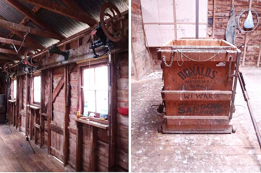
Exterior The woolshed is within a pastoral setting, and is an L shaped structure. It is placed almost directly next to the road, State Highway 2, approximately three kilometres south of Eketahuna. There are mature trees at the boundary of the paddock surrounding the woolshed, and the remnants of the native bush including totara, rimu and kahikatea can be found nearby. The rounded windows are a point of visual difference for the woolshed and form part of its attractive nature. The woolshed is the particular rusted red colour which is typical of these structures, a result of the red oxide paint used by the early settlers. The building was constructed from pitsawn totara, and currently has a corrugated iron roof. The woolshed is set seemingly precariously on hand-adzed native wooden piles. These form part of the charm of the building. There is a race on the south side of the woolshed that was added later when transportation vehicles no longer had their own ramps attached. Continuing around the structure there is a small outbuilding attached to the back of the building, and to the north there is a sheep pen for sheep to be released into after having been shorn. Interior The entrance to the woolshed is through a sliding door to the east. There are a further two hinged doors in this wall. This entrance way forms one half of the L shape, running east-west, and is a single storey with gable roof. The other half of the structure, also running east-west has an additional small roof which runs north-south and has a small door in it which may be for ventilation. On the north wall where the sheep pens are, are two corrugated iron doors which are rolled to the left and right respectively, and one set of six of the windows described above. There is also a four-pane sash window in this wall. The interior of the woolshed is constructed of native timber. There are three stands in the woolshed, and graffiti on the walls, adding to the patina of the building. There is a woolpress thought to date from the 1960s in the entrance way, with stencils for writing the name of the station on wool bales. There are shears in place on the east wall.
Exterior The woolshed is within a pastoral setting, and is an L shaped structure. It is placed almost directly next to the road, State Highway 2, approximately three kilometres south of Eketahuna. There are mature trees at the boundary of the paddock surrounding the woolshed, and the remnants of the native bush including totara, rimu and kahikatea can be found nearby. The rounded windows are a point of visual difference for the woolshed and form part of its attractive nature. The woolshed is the particular rusted red colour which is typical of these structures, a result of the red oxide paint used by the early settlers. The building was constructed from pitsawn totara, and currently has a corrugated iron roof. The woolshed is set seemingly precariously on hand-adzed native wooden piles. These form part of the charm of the building. There is a race on the south side of the woolshed that was added later when transportation vehicles no longer had their own ramps attached. Continuing around the structure there is a small outbuilding attached to the back of the building, and to the north there is a sheep pen for sheep to be released into after having been shorn. Interior The entrance to the woolshed is through a sliding door to the east. There are a further two hinged doors in this wall. This entrance way forms one half of the L shape, running east-west, and is a single storey with gable roof. The other half of the structure, also running east-west has an additional small roof which runs north-south and has a small door in it which may be for ventilation. On the north wall where the sheep pens are, are two corrugated iron doors which are rolled to the left and right respectively, and one set of six of the windows described above. There is also a four-pane sash window in this wall. The interior of the woolshed is constructed of native timber. There are three stands in the woolshed, and graffiti on the walls, adding to the patina of the building. There is a woolpress thought to date from the 1960s in the entrance way, with stencils for writing the name of the station on wool bales. There are shears in place on the east wall.
Historical and Associated Iwi / Hapū / Whānau
Completion Date
16th December 2010
Report Written By
Katharine Cox
Information Sources
Bagnall, 1976
A. G. Bagnall, Wairarapa; An Historical Excursion, Trentham, 1976
Cyclopedia of New Zealand, 1908
Cyclopedia Company, Industrial, descriptive, historical, biographical facts, figures, illustrations, Wellington, N.Z, 1897-1908, Vol. 6, Taranaki, Hawke's Bay, Wellington, 1908
Kernohan, 2003
D. Kernohan, Wairarapa Buildings: Two centuries of New Zealand architecture, Wairarapa Archive, Masterton, 2003
McLintock, 1966
An Encyclopedia of New Zealand, Government Printer, Wellington, 1966
Thornton, 1986
Geoffrey Thornton, The New Zealand Heritage of Farm Buildings, Auckland, 1986
Burr, 1995
V.A Burr, Mosquitoes and Sawdust: A history of Scandinavians in early Palmerston North and surrounding districts, Palmerston North, 1995
Adcock, 1973
I., Adcock, A Goodly Heritage: Eketahuna and districts 100 years, 1873-1973, Eketahuna, 1973
McFadgen, 2003
B, McFadgen, Archaeology of the Wellington Conservancy: Wairarapa. A study in Tectonic Archaeology. Department of Conservation, Wellington, 2003
Grant, 1995
Grant, I.F., North of the Waingawa: The Masterton Borough and County Councils, 1877-1989, Masterton, 1995
Best, 2001
P. Best, Eketahuna: Stories from small town New Zealand, Publishing Press Ltd, Auckland. 2001
Edmonds, 1987
J. Edmonds; Alfredton: the School and the People, Alfredton School Centennial Committee, Alfredton, 1987
Other Information
A fully referenced registration report is available from the NZHPT Central Region office Please note that entry on the New Zealand Heritage List/Rarangi Korero identifies only the heritage values of the property concerned, and should not be construed as advice on the state of the property, or as a comment of its soundness or safety, including in regard to earthquake risk, safety in the event of fire, or insanitary conditions.
Current Usages
Uses: Agriculture
Specific Usage: Woolshed/Shearing Shed
Former Usages
General Usage: Agriculture
Specific Usage: Woolshed/Shearing Shed
Current Usages
Uses: Agriculture
Specific Usage: Woolshed/Shearing Shed
Former Usages
General Usage: Agriculture
Specific Usage: Woolshed/Shearing Shed
Location
Stay up to date with Heritage this month
