The discovery and settlement of the Wairarapa region is connected with several prominent figures of New Zealand’s history. Ancestral figures such as Hau-nui-a-nanaia, Kupe, Whatonga, Tara Ika and Toi have all been said to have connections with the region and are responsible for the naming of many of the Wairarapa’s features and places. It has been estimated that Rangitane settled in the region by about the sixteenth century. Marriage links with Rangitane saw a group of Ngati Kahungunu retreat to the Wairarapa in the subsequent century as the result of internal hapu conflict. The two groups cohabitated mostly in the south Wairarapa for a period, but then the Ngati Kahungunu newcomers negotiated several sections of land for themselves. This process was not seamless and instances of conflict continued between the two iwi over the centuries. The next significant period of change in the area was in the early nineteenth century with the progression south of Te Rauparaha and others. This ushered in an era when many different iwi, including Ngati Whatua, Ngati Awa, Ngati Toa, Ngati Raukawa, Ngati Tama, and Ngati Mutunga, made advances into the region and some Ngati Kahungunu hapu withdrew.
European incursion into the Wairarapa only began after the New Zealand Company’s Port Nicholson settlement was established. Based on the reports of the exploring and surveying parties that the company sent out, the southern Wairarapa became one of the first extensive tracts of land to be occupied by Europeans, although the Crown titles, negotiated by Donald McLean, were not obtained until 1853. However, it took substantially longer for settlement to progress beyond Masterton, which was linked to Wellington by road in 1859. Further headway was slow because the northern Wairarapa was heavily forested, as opposed to the south with its relatively clear and large grass plains. In particular, the forest north of Mount Bruce was dense with rimu, tawa, matai, maire, kahikatea, and rata, and was known as Forty Mile Bush, which was within the larger Seventy Mile Bush that also encompassed places such as Dannevirke and Norsewood. Maori referred to this forest as Te Tapere Nui o Whatonga (The great forest of Whatonga) and an abundance of birdlife resided there amongst giant ancient trees, some of which were large enough for groups of local Maori to shelter within their trunks.
The forest acted as a significant barrier and therefore, while there was some European settlement in the northern Wairarapa before the late nineteenth century, it was not until roads were extended further and the railway link to Wellington established that the area was opened up for substantive settlement. In preparation for the construction of the railway the government had an active role in the foundation of several places in the Wairarapa and Tararua regions. Towns such as Mauriceville, Eketahuna, Norsewood, and Dannevirke were all initially formed as bases for the railway labourers. Part of the preparation for the railway construction included building a road through the district which had progressed by the mid to late 1870s.
To further encourage the wider clearing and settlement of the north Wairarapa from 1884 the Stout-Vogel Ministry instigated a scheme which involved people forming groups, known as small farmer associations, to buy tracts of land. There were conditions placed on the lease-to-own agreements for the land. For example, 10 per cent of the plot of land had to be in cultivation within two years, and the members of the association were, in the majority of cases, obligated to live on their section. This proved a relatively popular idea and eight land purchasing associations soon formed. These groups continued to be formed into the last decade of the nineteenth century, creating farmland around Pahiatua in the Mangahao, Mangaone, and Mangatainoka Blocks.
Mangatainoka started life as two settlements located either side of the Mangatainoka River, which were originally known as the Pahiatua Village and Mangatainoka Special Settlements. However, these separate settlements soon became referred to collectively as Mangatainoka. Because Mangatainoka was a Crown settlement there was a certain amount of animosity towards it from its close neighbour, the privately created town of Pahaiatua. The locals there felt that the government was trying to undermine enterprise by luring immigrants into its public works and land settlement schemes, but it seems to have been mostly because public facilities were set-up in the Crown settlements as a matter of course, while Pahiatua had to battle vociferously for them.
Mangatainoka’s public school was established, reasonably early in its history, in 1889. The foundation roll of 60 students is indicative of the growth of the settlement in the few years since its creation, and this continued with attendance numbering 200 students by 1900. The size of the school surprised some commentators given that the population of township itself was reasonably small, especially compared with Pahiatua. However, this is indicative of Mangatainoka being a service centre for a wider rural district, which was also reflected by it having other facilities, such as churches for a variety of denominations.
Like other communities in the region, Mangatainoka’s economy was based on the dairy industry with a creamery set up prior to the twentieth century and eventually a local cooperative factory was created in 1910. Consequently, it also seems to have had a healthy pig-raising industry developed due to the whey being good pig feed. However, these industries began to decline after the mid-twentieth century as mergers of cooperatives and factories meant a withdrawal from Mangatainoka. Other key local employers in the area were the railway, and the Tui Brewery which for generations has been synonymous with Mangatainoka.
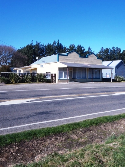
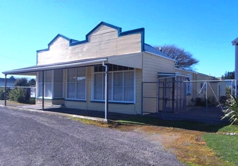
In 1902 it was said that ‘Mangatainoka is getting a stir on. A new grocery firm has commenced operations in the main street. They are satisfied the district will stand three general stores.’ This new shop seems to have been one of the two stores located to the north of the Mangatainoka River. The other one was Ashby’s Store built in 1893, which was opposite the school, and has now been removed. The only store south of the river, the one that is the focus of this report, is reported to have been constructed in 1894 by G. H. Walther, and housed the Post Office, as well as the first town hall.
Walther’s Town Hall and Post Office Store was damaged or destroyed by fire in 1897. However, from newspaper reports it appears that although the property was owned by Walther the shop was referred to as Mayne’s Store. The extent of the damage is not known, but if this shop was destroyed then this was probably the catalyst for the creation of a purpose-built Town Hall in 1898 to replace the facility no longer available at Walther’s property. This hall and public library building was opposite the school. However, the current building is a later version having being built in the early 1950s.
Although a set-back, Walther rebuilt the store and connected hall and saddlers shop, and the business continued to thrive into the early twentieth century under the new proprietorship of Charles John Walkley. Indeed, it does seems that this small rural service centre happily supported multiple general stores with both Walkley’s and Ashby’s being described as ‘always busy and giving it their best.’ Walkley’s was known as a place ‘where you could get almost everything…The shop windows: we could stand for ages and just look at the contents all spread out to be seen – buttons, cottons, shoes, and boots, materials by the yard, pots and pans, billies.’ Walkley acquired the nickname ‘Benzene Frank’ when his store was the first to supply petrol in the town, due to petrol then being transported and stored in benzene tins.
The MacPhersons were a longstanding local family who seem to have then owned the store for many decades following Ian MacPherson’s purchase of it in 1937. By this time the bus stop for students going to the Pahiatua District High School had been established out front of the building and it no doubt enjoyed good custom from the students who parked their bicycles on the south side of the building, adjacent to storeroom. However, not all customers could make it into the store, and MacPherson is said to have been a familiar sight on the country roads around Mangatainoka as he delivered groceries to rural customers in his little truck.
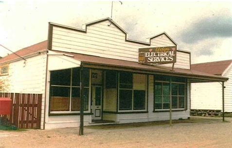
As previously mentioned, in the late nineteenth century the Post Office was located in Walther’s first general store. However, when the railway was opened in late 1897 the Post Office was relocated to the station. Later, in 1964 the local postal outlet came full circle, being once again based in the General Store. Successive Postmasters were store owners John Winnard, followed by David McKay, until the Post Office was withdrawn from the shop in 1976. It was also in this year that the McKay’s sold the building to John Udy who set up his electrical business there.
This shift in the function of the former general store is indicative of a wider societal change away from general stores as transport developments and large cut-price supermarket chains developed. In this respect Mangatainoka’s close proximity to the area’s biggest town, Pahiatua, no doubt affected the custom of the General Store. The electrical business seems to have operated for several decades, with the building later being home to a second-hand goods dealership. Currently the General Store (Former) is used solely as a residence. The current owners report that travellers through Mangatainoka during the 2011 Rugby World Cup showed considerable interest in the building.