

List Entry Information
Status
Listed
List Entry Status
Historic Place Category 1
Access
Private/No Public Access
List Number
4405
Date Entered
27th July 1988
Date of Effect
27th July 1988
City/District Council
Dunedin City
Region
Otago Region
Status
Listed
List Entry Status
Historic Place Category 1
Access
Private/No Public Access
List Number
4405
Date Entered
27th July 1988
Date of Effect
27th July 1988
City/District Council
Dunedin City
Region
Otago Region
Why is this place significant?
Historic Significance
This historic place was registered under the Historic Places Act 1980. The following text is the original citation considered by the NZHPT Board at the time of registration. Information in square brackets indicates modifications made after the paper was considered by the HNZPT Board. Historical Significance or Value One of the first major tasks of the settlers on the Otago Peninsula was to clear their land of both trees and stones. Even farmers who did not or could not build walls piled stones along boundaries and into heaps. The walls not only provided durable, low maintenance fences but also shelter around houses and yards and along ridge lines. Stone walling was a traditional skill for many of the farmers who came from Scotland, and a desire to create a familiar landscape may also have encouraged wall building. Wire for fencing did not become common until after 1880 and required cash to buy, whereas collecting stones off the fields cost only the labour involved. There is little historical evidence about the identities of the professional fencing contractors who built stone walls on the Peninsula but who were not qualified masons. Their existence is deduced from the quality of the walls which local farmers such as Ian Robertson sat were built by professional wallers and not by stone masons. The latter were trained to dress stone and mortar the blocks for which they were paid higher wages than a fencing contractor. Stone walls known to have been made by masons tend to be on farms which they themselves owned, such as William Dick's at Sandymount and James Baird's at Mihiwaka. Stone walls thought to have been built by farmers untrained in walling are much poorer in quality and now decayed. The quality of the Robertson stone walls varies sufficiently to suggest that different wallers built them. [The farm was taken up by the Stuart family whose descendants have owned the farm ever since. Ian Robertson is the great-grandson of the original settler and he and his wife, Pat, lived on the property until their retirement, when their son took over the farm].
Physical Significance
Architectural Significance: Simple vernacular structures. Townscape/Landmark Significance: Stone walls occur around Dunedin wherever lava flows have left boulders in arable fields. They occur in distinct groupings on these flows and give the landscape of such places as the Otago Peninsula, Mount Cargill and Wakari and unusual and characteristic pattern.
Why is this place significant?
Historic Significance
This historic place was registered under the Historic Places Act 1980. The following text is the original citation considered by the NZHPT Board at the time of registration. Information in square brackets indicates modifications made after the paper was considered by the HNZPT Board. Historical Significance or Value One of the first major tasks of the settlers on the Otago Peninsula was to clear their land of both trees and stones. Even farmers who did not or could not build walls piled stones along boundaries and into heaps. The walls not only provided durable, low maintenance fences but also shelter around houses and yards and along ridge lines. Stone walling was a traditional skill for many of the farmers who came from Scotland, and a desire to create a familiar landscape may also have encouraged wall building. Wire for fencing did not become common until after 1880 and required cash to buy, whereas collecting stones off the fields cost only the labour involved. There is little historical evidence about the identities of the professional fencing contractors who built stone walls on the Peninsula but who were not qualified masons. Their existence is deduced from the quality of the walls which local farmers such as Ian Robertson sat were built by professional wallers and not by stone masons. The latter were trained to dress stone and mortar the blocks for which they were paid higher wages than a fencing contractor. Stone walls known to have been made by masons tend to be on farms which they themselves owned, such as William Dick's at Sandymount and James Baird's at Mihiwaka. Stone walls thought to have been built by farmers untrained in walling are much poorer in quality and now decayed. The quality of the Robertson stone walls varies sufficiently to suggest that different wallers built them. [The farm was taken up by the Stuart family whose descendants have owned the farm ever since. Ian Robertson is the great-grandson of the original settler and he and his wife, Pat, lived on the property until their retirement, when their son took over the farm].
Physical Significance
Architectural Significance: Simple vernacular structures. Townscape/Landmark Significance: Stone walls occur around Dunedin wherever lava flows have left boulders in arable fields. They occur in distinct groupings on these flows and give the landscape of such places as the Otago Peninsula, Mount Cargill and Wakari and unusual and characteristic pattern.
Construction Details
Start Year
1896
Type
Original Construction
Construction Materials
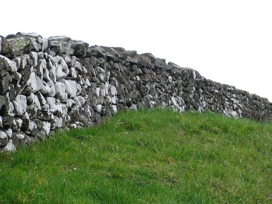
The wall along the road boundary at Clifton is protected under the Dunedin District Scheme though it is not the best wall on the property. The walls down the driveway and along the south boundary of the property are taller and better built. In general though the Clifton walls are good examples of the better stone walls prevalent on the Otago Peninsula. The average height of the driveway walls is 1.75 metres, and the walls are about one metre wide at the base reducing to about 0.66 metres at the coping. There is a total length of about 1.6 kilometres of wall, including the road and driveway walls and sections on the south and lower boundaries. The stones used are the undressed, grey, rounded, volcanic boulders removed from the adjacent fields. (An important effect of stone walling was to clear the fields of stones as well as create stock fences.) The courses tend to be ungraded and relatively uneven, with sometimes uncrossed joints. The coping is made of even large through stones, projecting slightly on either side.
Notable Features
The height of the walls, their professional construction and good repair.
Construction Details
Start Year
1896
Type
Original Construction
Construction Materials
The wall along the road boundary at Clifton is protected under the Dunedin District Scheme though it is not the best wall on the property. The walls down the driveway and along the south boundary of the property are taller and better built. In general though the Clifton walls are good examples of the better stone walls prevalent on the Otago Peninsula. The average height of the driveway walls is 1.75 metres, and the walls are about one metre wide at the base reducing to about 0.66 metres at the coping. There is a total length of about 1.6 kilometres of wall, including the road and driveway walls and sections on the south and lower boundaries. The stones used are the undressed, grey, rounded, volcanic boulders removed from the adjacent fields. (An important effect of stone walling was to clear the fields of stones as well as create stock fences.) The courses tend to be ungraded and relatively uneven, with sometimes uncrossed joints. The coping is made of even large through stones, projecting slightly on either side.
Notable Features
The height of the walls, their professional construction and good repair.
Architect/engineer/designer: Professional wallers of varying skills, names not known, employed by the Stuart family over about 30 years. Architectural Description (style): These walls are Galloway double dykes, that is they are the type of stone field wall built in south west Scotland in which two faces of carefully placed large stones are built up leaning towards one another with a fill of smaller stones in the centre. Modifications: Wallheads and gate ends are starting to decay but some have been repaired. Part of the wall near the main gate was knocked down by a vehicle and has been rebuilt by Ian Robertson. There is a tendency for passers by to take stones away from the top of the wall. In general the state of repair is good though there are some gaps which have been filled with other materials.
Architect/engineer/designer: Professional wallers of varying skills, names not known, employed by the Stuart family over about 30 years. Architectural Description (style): These walls are Galloway double dykes, that is they are the type of stone field wall built in south west Scotland in which two faces of carefully placed large stones are built up leaning towards one another with a fill of smaller stones in the centre. Modifications: Wallheads and gate ends are starting to decay but some have been repaired. Part of the wall near the main gate was knocked down by a vehicle and has been rebuilt by Ian Robertson. There is a tendency for passers by to take stones away from the top of the wall. In general the state of repair is good though there are some gaps which have been filled with other materials.
Historical and Associated Iwi / Hapū / Whānau
Information Sources
New Zealand Historic Places Trust (NZHPT)
New Zealand Historic Places Trust
Other Information
This historic place was registered under the Historic Places Act 1980. This report includes the text from the original Building Classification Committee report considered by the NZHPT Board at the time of registration. Please note that entry on the New Zealand Heritage List/Rarangi Korero identifies only the heritage values of the property concerned, and should not be construed as advice on the state of the property, or as a comment of its soundness or safety, including in regard to earthquake risk, safety in the event of fire, or insanitary conditions.
Historical and Associated Iwi / Hapū / Whānau
Information Sources
New Zealand Historic Places Trust (NZHPT)
New Zealand Historic Places Trust
Other Information
This historic place was registered under the Historic Places Act 1980. This report includes the text from the original Building Classification Committee report considered by the NZHPT Board at the time of registration. Please note that entry on the New Zealand Heritage List/Rarangi Korero identifies only the heritage values of the property concerned, and should not be construed as advice on the state of the property, or as a comment of its soundness or safety, including in regard to earthquake risk, safety in the event of fire, or insanitary conditions.
Former Usages
General Usage: Civic Facilities
Specific Usage: Wall/Fence
Former Usages
General Usage: Civic Facilities
Specific Usage: Wall/Fence
Location
Sign up to hear more
Get the latest heritage news, features and events delivered
straight to your inbox.
