

From at least the late nineteenth century there had been attempts to construct a railway connecting Gisborne with Napier. The difficult terrain between the two settlements made the New Zealand Government, the principal investor in the country's railway network, reluctant to invest money on such a project. In addition, Maori landowners were unwilling to sell their land for the railway. In 1900 a railway league was formed to advocate for lines to Auckland via Rotorua and a line connecting Wellington to Wairoa. It was not until 1911 that the latter line was approved and work began in 1912. Construction on the new railway was halted during the First World War. During the 1920s further delays were caused by a debate on whether to go by the coastal route or inland. Finally in about 1928 a decision was made to build the railway along the coastal route and work recommenced.
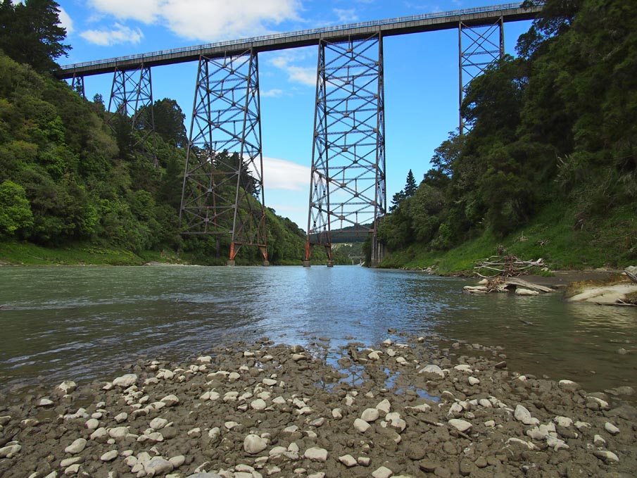
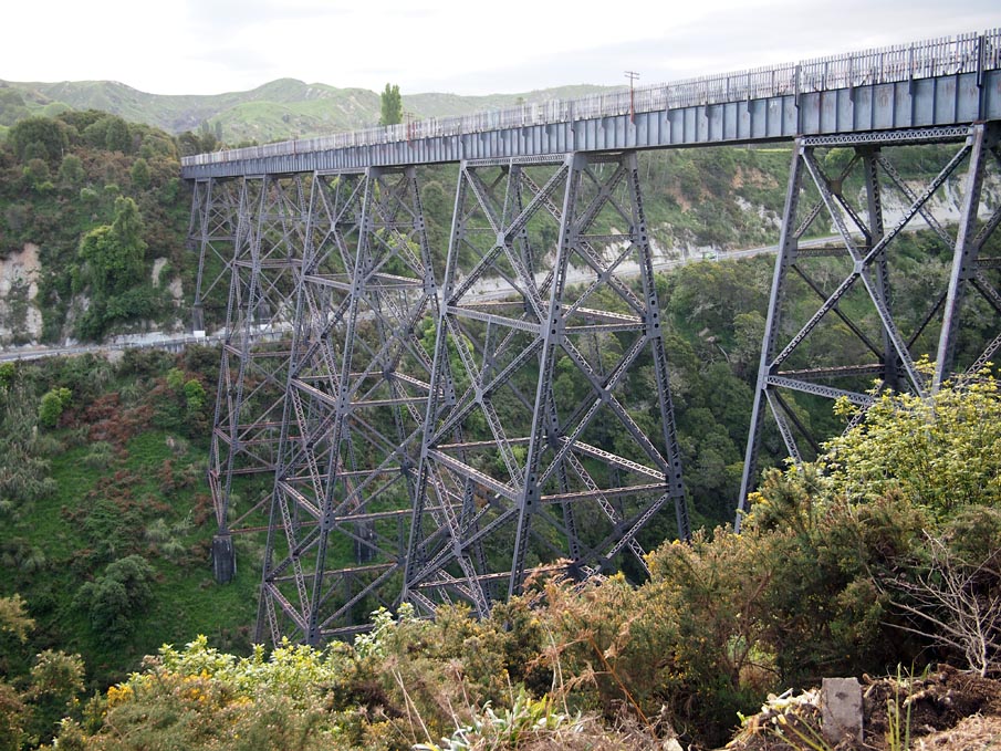
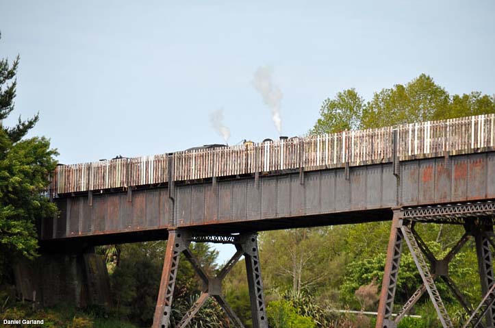
The Mohaka Viaduct was designed by New Zealand-born engineer John E. L. Cull (1878-1943). Educated in Christchurch and London, Cull had held various positions including university lecturer and assisting local bodies, before being appointed in 1914 as the first designing engineer for the Public Works Department. Cull's design for the viaduct called for a bridge 277 metres in length, 95 metres high, supported by five piers/towers. To protect the viaduct and the trains from the wind, a stout windbreak was designed to be placed above the girders. Cull resigned in 1929 and William Newnham (1888-1974), who had previously been employed by Public Works as assistant to the design engineer, took over the project. (Newnham was later appointed Engineer-in-Chief and Under Secretary of Public Works in 1941.)
In 1931 the Railways Board, the body that controlled the construction of railway throughout New Zealand, recommended that, due to the economic conditions brought on by the Great Depression, work on the track be stopped. By this stage the foundations of the viaduct had been completed, and the iron and steelwork, which had been prefabricated at the Railways Department workshops, Tauranga, had been transported to the site.
In 1935 the first Labour Government was elected. Labour saw the State as having a key role in reinvigorating the economy through government initiated public works. In 1936 the government introduced the Government Railways Amendment Act ending the Railways Board, and from 1 April 1936 control of the railways reverted to the government through the Minister of Railways. Work on the Napier-Wairoa-Gisborne line was resumed in that same year. On 31 June 1937, at a ceremony attended by the Minister of Railways, the Leader of the House of Representatives, and a number of community dignitaries, the Minster of Public Works, Robert Semple (1873-1958) drove that last spike in on the viaduct. The remaining line between Wairoa and Gisborne was not completed until August 1942. The line was officially handed over by Public Works to the New Zealand Railways Department on 1 February 1943.
The Mohaka Viaduct has great technical significance as the tallest viaduct in Australasia. It is an impressive engineering feat constructed of prefabricated steel components made by the Public Works Department. Constructed largely in the wake of the Depression, the Mohaka Viaduct was an important factor in the completion of the railway line, which opened up Northern Hawke's Bay and Poverty Bay, reducing the isolation of Wairoa and, to a lesser extent, Gisborne. Sited above the Mohaka River and above State Highway 2, this imposing viaduct is a renowned local landmark.
List Entry Information
Status
Listed
List Entry Status
Historic Place Category 1
Access
Private/No Public Access
List Number
4418
Date Entered
28th June 1990
Date of Effect
28th June 1990
City/District Council
Wairoa District
Region
Hawke's Bay Region
Extent of List Entry
Extent includes part of the land described as Railway Land (NZ Gazette 1926, p.2348), Hawke’s Bay Land District and the structure known as the Mohaka Viaduct thereon, including its abutments. Refer to the extent map tabled at the Rārangi Kōrero meeting on 9 November 2017.
Legal description
Railway Land (NZ Gazette 1926, p.2348), Hawke’s Bay Land District
Why is this place significant?
Cultural Significance
Sited above the Mohaka River and above State Highway 2, this imposing viaduct is a renowned local landmark.
Historic Significance
Historical Significance or Value Constructed largely in the wake of the Depression, the Mohaka Viaduct was an important factor in the completion of the railway line, which opened up Northern Hawke's Bay and Poverty Bay reducing the isolation of Wairoa and, to a lesser extent, Gisborne.
Physical Significance
The Mohaka Viaduct is significant in that at a height of 95 metres above the Mohaka River it is the tallest viaduct in Australiasia. It is an impressive engineering feat constructed of mild steel components prefabricated at the Public Works Department Workshops at Mount Maunganui, near Tauranga. The prefabrication of steel bridge at a base workshop was practised in New Zealand from the 1880s.
Construction Professional
Name
Cull, John Ernest Lelliott
Type
Architect
Biography
Born in Christchurch in 1878, John Ernest Lelliott Cull studied at Canterbury University College before taking his degree in England. He began his professional career with Cutten Bros in 1898 in the field of dredge design. He was then a member of the staff of Canterbury University College (1902-06) and was frequently consulted by local bodies on engineering matters. He became assistant engineer to the Auckland Drainage Board and was involved with mining and local body work in that region. This was followed by a period as inspecting engineer to the Auckland Harbour Board. In 1914 he was employed by the Public Works Department. He was the department's first designing engineer and held this position until 1920, during which time he was responsible for the design of the Mohaka Viaduct. In 1929 he took up the chair of Civil Engineering at Canterbury University College, remaining there until his retirement in 1941. Professor Cull was Chairman of the Building Regional Committee set up following the 1931 Napier earthquake to draw up standards for earthquake resistant building in the affected area. This committee drafted standard specifications for buildings likely to be erected in earthquake prone areas. Cull served as president of the New Zealand Institution of Engineers. He died in 1943.
Construction Details
Start Year
1937
Type
Original Construction
Notable Features
Tallest viaduct in Australasia. Wooden windbreak.
Historical and Associated Iwi / Hapū / Whānau
Completion Date
21st November 2002
Report Written By
Helen McCracken
Information Sources
Bellamy, 1961
A. C. Bellamy, 'The Napier to Gisborne Railway', Wanganui, April 1961, Wanganui
Evening Post
Evening Post, 27 Jun 1919, p.7.
Wilson, 1961
James Wilson, Notes on Railway Bridges in New Zealand, New Zealand Railways Department, 1961
Hawke's Bay Daily Herald
Hawke's Bay Daily Herald
Leitch, 1988
David Leitch and Bob Stott, New Zealand Railways: The First 125 Years, Auckland, 1988
New Zealand Railway Magazine
The New Zealand Railway Magazine
Troup, 1973
Gordon Troup (ed), Steel Roads of New Zealand: An Illustrated Survey, A H & A W Reed, Wellington, 1973.
Other Information
This place was identified as significant under previous legislation with different information requirements. It remains significant under the current legislation. There is opportunity under our legislation and policies to add to this information. Further information about this place may be available from the Central Regional Office of Heritage New Zealand Pouhere Taonga. Please note that entry on the New Zealand Heritage List/Rarangi Korero identifies only the heritage values of the property concerned, and should not be construed as advice on the state of the property, or as a comment of its soundness or safety, including in regard to earthquake risk, safety in the event of fire, or insanitary conditions.
Current Usages
Uses: Transport
Specific Usage: Bridge/ Viaduct
Former Usages
General Usage: Transport
Specific Usage: Bridge/ Viaduct
Web Links
description: Engineering NZ Heritage
url: https://www.engineeringnz.org/our-work/heritage/heritage-records/mohaka-viaduct/
Current Usages
Uses: Transport
Specific Usage: Bridge/ Viaduct
Former Usages
General Usage: Transport
Specific Usage: Bridge/ Viaduct
Web Links
description: Engineering NZ Heritage
url: https://www.engineeringnz.org/our-work/heritage/heritage-records/mohaka-viaduct/
Location
Sign up to hear more
Get the latest heritage news, features and events delivered
straight to your inbox.
