

In the nineteenth century, Ōamaru’s coast became notorious for the number of wrecks close to shore. It became obvious that a breakwater was vital if safe anchorage was to be provided. Work began on building the breakwater in April 1871 - a 1,200 foot (370 metre) breakwater, and a tramway running from the landing place at the southwest corner of the bay to the breakwater site at the foot of the cape. The contract was awarded to Walkem and Peyman.
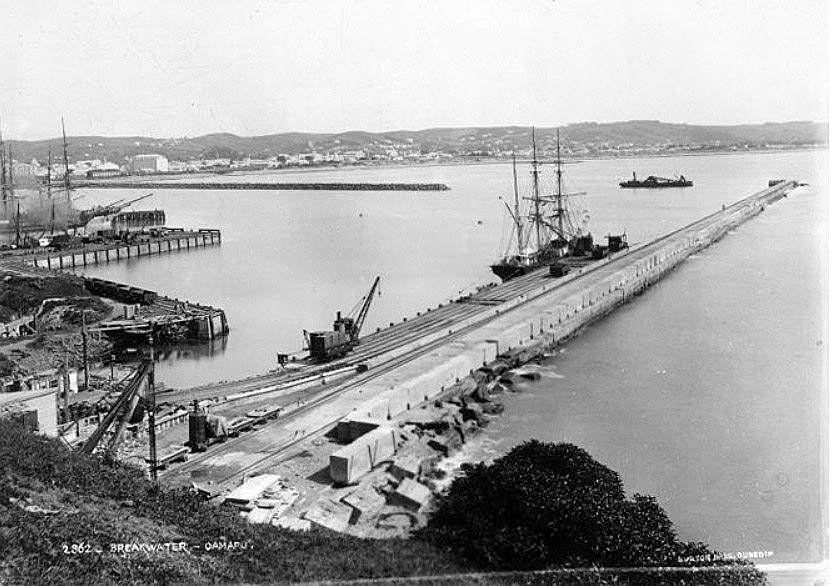
Construction of the tramway was completed by June 1872. The first stone of the breakwater was laid on 10 September 1872. Concrete blocks manoeuvred into position by what was said at the time to be the world's largest crane serving as a template for future cranes and linking the breakwater project to the significant nineteenth century history of port harbour and crane technology. Work on the breakwater progressed only slowly – by 1874 only 300ft (around 91.5 metres) was complete. By 1878 the breakwater reached 940ft (287 metres) in length and was finally completed by December 1884, at a length of 1,850ft (564 metres).
The Harbour Board decided to build a wharf to lie on the inside of the breakwater. The Dock Trust approved the plans in April 1874. The wharf was constructed of solid concrete and to measure 150ft by 20ft (46 metres by 6 metres). Walkem and Peyman were again the successful tenderers. The wharf was named Macandrew (after James Macandrew, the second Superintendent of Otago) and opened 5 May 1875. The total length of the wharf was 330 ft (just over 100 metres). It was traversed by two 30 ton travelling cranes and was used by steamers and coastal sailing vessels.
The subsequent history of the breakwater is characterised by stories of damage and repair. A storm in 1886 created a large gap near the end of the breakwater. The government advanced the Harbour Board money to affect the repairs, and work began on these in 1888. In the 1930s the breakwater was again under threat. Blasting began at the quarry in November 1932 to provide rocks to repair it and the Harbour Board used unemployed labour, subsidised under the Unemployment Board’s No. 5 Scheme, to lay new railway tracks along the breakwater to haul heavy rocks out and dump them on the seaward side to form a protective apron seven feet (2 metres) high and several chains long. In total, 7,550 tons of rock was placed alongside the breakwater.
In 1936, the construction of the Ramsay Extension began, but was not completed until 1944. In the mid-1950s the extension was abandoned and eventually broke up. A report from harbour engineer M. Treuville, recommended that 25-ton tetrapods be used to protect the breakwater, and these were positioned in 1956. The breakwater was breached again in 1977 and the breach repaired by placing large rocks on the seaward side and filling the cavity with bitumen. In 2017, the Macandrew Wharf and Breakwater remain significant elements in Ōamaru’s historic harbour.


List Entry Information
Status
Listed
List Entry Status
Historic Place Category 1
Access
Private/No Public Access
List Number
4882
Date Entered
25th September 1986
Date of Effect
7th June 2018
City/District Council
Waitaki District
Region
Otago Region
Extent of List Entry
Extent includes part of the land described as Section 11 SO 500094, (RT 814656, NZ Gazette 2017 In 5786), and part of the land described as Lot 1 DP 421926 (seabed, no title), Otago Land District, and the structures known as Oamaru Harbour Breakwater and Macandrew Wharf thereon.
Legal description
Section 11 SO 500094 (RT 814656, NZ Gazette 2017 In 5786), Lot 1 DP 421926 (seabed, no title), Otago Land District
Why is this place significant?
Historic Significance
Historical Significance or Value Oamaru Harbour Breakwater and Macandrew Wharf have special historic significance as the structures that underpinned the economic development of Ōamaru, resulting in the outstanding townscape that survives today. They represent New Zealand’s heritage of coastal engineering and also the history of Ōamaru’s development as a small coastal town in the mid to late nineteenth century. The harbour’s subsequent decline and eventual closure also reflects New Zealand’s provincial history in the twentieth century.
Physical Significance
Aesthetic Significance or Value Oamaru Harbour Breakwater and Macandrew Wharf have aesthetic significance as a powerful visual reminder of our coastal engineering heritage. The breakwater, built to protect the Ōamaru’s developing harbour from the force of the Pacific Ocean, bears witness to the engineers’ fight against the power of nature. These low concrete structures, which can be accessed by foot when it is safe to brave the waves, provide a strong sense of the vulnerability of such coastal engineering works and the work that went into creating a safe haven for coastal shipping. Archaeological Significance or Value Oamaru Harbour Breakwater and Macandrew Wharf have archaeological significance. Dating from the mid-1870s, these structures are part of the archaeological landscape of Ōamaru Harbour. The breakwater and wharf along with other harbour buildings, features and structures have the potential to show the technologies of a nineteenth century harbour through archaeological methods. Technological Significance or Value Oamaru Harbour Breakwater and Macandrew Wharf have technological significance as nineteenth century concrete harbour structures. The chronology and technologies used in the construction of both can be read in the structures themselves. Together, they provide insight into the original construction and the subsequent engineering efforts to repair the breakwater.
Why is this place Category 1 / Category 2?
Detail Of Assessed Criteria
This place was assessed against, and found to qualify under the following criteria: a, b, c, f, g, j, k. It is considered that this place qualifies as a Category 1 historic place. (a) The extent to which the place reflects important or representative aspects of New Zealand history Oamaru Harbour Breakwater and Macandrew Wharf have outstanding significance in their links to the Ōamaru’s widely recognised history. The harbour structures, the breakwater in particular, provided harbour protection that enabled Ōamaru’s ongoing development. (b) The association of the place with events, persons, or ideas of importance in New Zealand history Oamaru Breakwater and Macandrew Wharf are associated with significant harbour engineer John McGregor. McGregor worked on a number of important engineering projects, including Dunedin’s Ross Creek Reservoir, the Oamaru Breakwater, completed an engineering survey of the Waihao Valley, and substantial works at Auckland Harbour. (c) The potential of the place to provide knowledge of New Zealand history Both Oamaru Harbour Breakwater and Macandrew Wharf have potential to provide knowledge about the development of a nineteenth century harbour and the heritage of New Zealand coastal engineering through archaeological methods. Details of the construction technologies could be further revealed through physical examination. (f) The potential of the place for public education Oamaru Harbour Breakwater and Macandrew Wharf have potential for public education through both experience and interpretation. The structures are open to the public, unlike the historic remains of the other provincial ports which have been overtaken by modern port infrastructure, thereby restricting access. Onsite interpretation provides historical information about the structures. (g) The technical accomplishment, value, or design of the place Oamaru Harbour Breakwater and Macandrew Wharf show technical accomplishment as a significant harbour engineering project from the 1870s. The use of concrete and of the world’s largest movable steam crane provides insight into the technologies used to build these structures. (j) The importance of identifying rare types of historic places Oamaru Harbour Breakwater and Macandrew Wharf are rare examples of relatively intact structures associated with nineteenth century development of harbours on New Zealand’s open coasts. Of New Zealand’s artificial harbours (Timaru, New Plymouth and Napier), Ōamaru’s is the least altered, and the breakwater and Macandrew Wharf are outstanding, having not been incorporated into later harbour developments, as has happened in Timaru, New Plymouth and Napier. (k) The extent to which the place forms part of a wider historical and cultural area Oamaru Harbour Breakwater and Macandrew Wharf are key elements in the Oamaru Harbour Historic Area (List No. 7536), and have an important link with the Oamaru Historic Area (List No. 7064), helping to tell a cohesive story of Ōamaru’s development.
Construction Professional
Name
Walkem and Peyman
Type
Builder
Biography
Walkem and Peyman were contractors who were responsible for the construction of the Oamaru breakwater between 1871 and 1877. Mark Walkem (c.1815-1884) was a Jersey-born contractor working in partnership with his son-in-law Alexander Peyman. Walkem was active in Dunedin from around 1864. He died at the residence of his son-in-law in June 1884. Alexander Peyman (c.1830-1890). Peyman married Mark Walkem’s daughter Elizabeth Ruth in Melbourne in 1868. Peyman shifted to Ōamaru to work on the breakwater, living at Weraroa on Tees Street. Peyman and his family shifted to Leamington in England, where he died in 1890. Source: Review Report for Oamaru Harbour Breakwater and Macandrew Wharf, ŌAMARU, List No. 4882, 14 May 2018, Heather Bauchop
Name
McGregor, John
Type
Engineer
Biography
http://www.ipenz.org.nz/heritage/bio-detail.cfm?id=62
Construction Details
Start Year
1871
Finish Year
1872
Type
Original Construction
Start Year
1886
Type
Damaged
Description
Breakwater damaged in a storm
Start Year
1887
Finish Year
1889
Type
Refurbishment/renovation
Description
Breakwater repaired and strengthened
Start Year
1911
Type
Modification
Description
Light staff at the end of the breakwater replaced by 7.9m lattice tower
Start Year
1944
Type
Modification
Description
Ramsay Extension sealed off
Start Year
1975
Type
Other
Description
Port closed for shipping
Start Year
2001
Type
Modification
Description
Failed breakwater repairs
Start Year
2006
Type
Modification
Description
Tetrapod construction resumed
Start Year
1874
Type
Original Construction
Description
Construction of Macandrew Wharf begun
Start Year
1875
Type
Original Construction
Description
Macandrew Wharf completed
Finish Year
1884
Type
Original Construction
Description
Breakwater completed
Start Year
1936
Type
Addition
Description
Ramsay Extension to the breakwater
Start Year
1957
Type
Structural upgrade
Description
Tetrapods installed to protect breakwater
Construction Materials
Concrete
The Waitaki area is traditionally associated with the Kāhui-tipua, Te Rapuwai, Waitaha and Kāti Mamoe peoples. The land around the Waitaki River Mouth shows evidence of extensive settlement, while Moeraki was one of the early cradles of knowledge for Waitaha and Kāti Mamoe histories. Key coastal settlements were at Moeraki, Shag Point, Waikouaiti, and Huriawa (the Karitane Peninsula). Ngāi Tahu’s prehistoric presence is shown through a range of archaeological sites from middens and urupā, to rock art. Ngāi Tahu named the area in the lee of the cape, Ōamaru or the place of Maru, making use of the resources of the area. From the arrival of the Polynesian peoples to the 1940s, New Zealanders were ‘entirely dependent on sea transport for international trade and travel.’ The windy coast was a hazard to waka and European shipping alike. Coastal settlement Like other colonies such as Australia, European settlements in New Zealand were established on the coast. Settlements grew around natural harbours – such as Wellington, Dunedin, and Auckland. Also like Australia, other coastal settlements centred on land-based resources (gold, wool, or wheat, for example) which required coastal protection structures. Some settlements were based around river ports, which had a different set of difficulties, for example crossing the bar in places such as Westport. On exposed coasts with poor berthing facilities, ships had to unload close to shore at the roadstead vulnerable to sudden weather changes. Often, they would have to raise anchor and run for the open sea to avoid being driven ashore by strong winds or swells. New Zealand’s ‘crumpled’ landscape meant that road and rail networks were difficult to develop and a ‘myriad of little ports’ was the only way to connect settlements. Open coasts, such as those at New Plymouth, Napier, Timaru and Ōamaru, required specific structures to develop their harbours. In these unprotected places there was difficulty transferring cargo and passengers between ocean-going ships and the shore. Around these ports, road and rail transport networks spread inland. Engineering historian Michael Gourlay writes that in Australia nineteenth century coastal engineering was largely port and harbour engineering, and that the engineers were almost always British, and they were civil engineers, with experience in more than one field of public works. This was also the situation in New Zealand. Ōamaru developed in shelter of Cape Wanbrow to supply sheep stations. The Cape gave some protection from southerly winds, but was exposed to the prevailing north easterly. The first structure at Ōamaru was a derrick provided to haul goods up from the beach to the provincial government’s warehouse; this was followed by a flagstaff and some moorings at the bay. By 1860, with the beaching of the schooner Oamaru Lass, the dangers of the coast became clear. Engineer James Balfour designed an iron-piled L-shaped jetty near the end of Cape Wanbrow for the provincial government. The jetty was finished towards the end of 1867. The need for coastal protection: building a breakwater Ōamaru’s coast was notorious for drownings and shipwrecks. In one storm in July 1867 three ships were wrecked on the shore. McLean writes that ‘three ships resting unhappily on the beaches was a bad advertisement for Oamaru.’ Two weeks later the schooner Banshee was driven ashore, joining the other three ships. The unprotected jetty had a short life – a storm in February 1868 sank two wool ships and a coaster and mangled the new jetty. Locals demanded their own port, rejecting the provincial harbourmaster’s proposal to link, by rail, Ōamaru and his preferred port of Moeraki. The provincial government commissioned engineers Edward Dobson and John Blackett to report on port options. The engineers recommended building a small wet dock in the Brewery Lagoon (near where the Meek’s Grain Elevator building is today), the dock protected by seawalls running out from the end of the Cape. The Oamaru Dock Trust struggled with the project: Dobson and Blackett refused to oversee it, and engineer David Balfour who was their next choice, drowned off the coast of Timaru. John McGregor took over supervising the work. Walkem & Peyman, the contractors, started building concrete blocks for the south-east seawall in 1871. Money difficulties forced the Dock Trust to concentrate on the seawall rather than the dock. The first section was a 240 metre long breakwater. The breakwater had a rubble filled cavity between two rows of 4-high concrete blocks, which changed to solid concrete construction as the breakwater was extended further into the sea. The rock from the nearby harbour quarry was too weak to withstand the sea so concrete was essential. The cement was imported from Britain, the casks buried nearby as part of the associated reclamation. In 1873, a ‘massive rail-mounted steam travelling crane’ manufactured by Dunedin engineering firm Kincaid, McQueen & Co. provided the muscle for the project. The crane was the ‘largest full-slewing rail-mounted steam crane capable of travelling with a rated load anywhere in the world.’ The work was staged – it was often delayed by weather and became more difficult as the breakwater reached deeper waters. Divers were used to help level the seabed where the concrete blocks were to be placed. The most difficult part of the job was sinking the four caissons (watertight retaining structures) that were to form the seaward end of the breakwater. The caissons were floated to the end of the breakwater then filled with 600-700 tonnes of concrete and bound together with a concrete cap – making the head of the breakwater. It was February 1884 before the last caisson was in place. Detractors doubted that such a ‘juvenile excrescence’ was going to offer much competition to Dunedin’s preeminent position. But the Oamaruvian gentlemen had a dream; in a 1908 potted history of the port, the Otago Witness summed up (facetiously – given the financial problems) their vision: ‘Snuggled in around the corner formed by Cape Wanbrow and the East Coast they saw a great city; behind it, and to the south and north, miles and miles of fertile rolling plains stretched away, whereon grew wheat and oats and potatoes, sheep and cattle, in great confusion. All round they saw the vomiting smoke stacks of countless factories, and cosily berthed behind a big breakwater, many inter-ocean steams, filling capacious holds with the produce of North Otago….’ The advance of the breakwater allowed for the construction of wharves behind its protective walls. The first was the 46 metre Macandrew Wharf, completed against the landward end of the breakwater in 1875. The wharf meant passengers could disembark on solid ground rather than into a surfboat. Normanby Wharf was completed in 1878 and Cross Wharf in 1879. The wharves gave Ōamaru 370 metres of sheltered berths. Shipping accidents virtually ended. In 1879 Thomas Forrester, architect and secretary/engineer to the Oamaru Harbour Board, made trial bores and discovered the harbour could be dredged. This discovery opened the way to making Ōamaru a deepwater port, able to handle shipping from Britain. A large export wharf (Sumpter Wharf) was completed in 1884. The first ship to dock at Sumpter Wharf was Dunedin, the ship which had carried the first shipment of frozen meat from Dunedin in 1881. The second ship was the Elderslie, twice the size of the Dunedin, ‘the first frozen meat steamer for the New Zealand trade and initially intended to trade solely between Oamaru and London.’ It was the ports that created progress, jobs and business. Timaru and Ōamaru fought for their status in the 1880s. The construction of the breakwater and Macandrew Wharf at Ōamaru between 1871 and 1884 was vital to create a safe anchorage for ships along a notoriously dangerous coast. Its construction helped the town of Ōamaru prosper into the late-nineteenth century hub of North Otago. Historian Gavin McLean reports the envy of nearby Timaru: ‘A breakwater with a mole at the end of it, a wharf with a big hole dredged alongside, and what is more satisfactory. A big steamer lying in the big hole, loading up a huge cargo of mutton: all these things indicate progress, show a spirit of enterprise and auger well for the future prosperity of Ōamaru.’ McLean writes ‘[i]ronically, by the time the breakwater was finally capped off and Sumpter Wharf was lined with ships, the local economy had nose-dived. For some time the Long Depression had been settling over the colony and Oamaru’s growth spurt came to a sudden stop virtually at the same time as the mole, breakwater and Sumpter Wharf were finished and the grandest of the Harbour/Tyne Street precinct grain stores opened their doors. The town’s population would not regain its 1881 numbers until the 1920s.’ A further blow came with the major damage to the breakwater in August 1886, which tore a 100 metre gap at the outer end of the structure. The twentieth century Harbour developments did continue in the early years of the twentieth century. Holmes Wharf was built on top of the mole in 1906 to allow for the berthing of the new larger overseas ships. The harbour retained its trade into the 1930s. One of the Harbour Board’s major twentieth century projects was extending the breakwater. From as early as 1913, the board planned an angled extension to provide a sheltered shipping channel in deeper water. The extension was planned to be at an angle some two-thirds along the length of the breakwater. Lack of money meant the project was not undertaken until the 1930s. In 1933 engineer F.W. Furkert recommended a 280 metre extension as the first stage. In 1936 the Board used unemployed labour and rock from its own quarry to raise the breakwater along its landward end to provide a solid base for the new work. By the end of 1936 the Board began dumping rock for the Ramsay Extension. Work proceeded slowly – out 100 feet (30 metres) by 1937, to 140 feet (42.7 metres) in 1938 and to 205 feet in 1940 (62.5 metres). By 1942 the extension was 365 foot long. When the Oamaru Harbour Board sealed off the extension, it was 140 feet short of the original length and 520 feet short of Furkert’s recommendation. By 1944 the project was still incomplete and was abandoned. By the mid-1950s, the extension was disintegrating and also accelerating damage to the old breakwater. The port declined further as the Cook Strait road/rail ferries killed conventional shipping. In 1974, the last ship called at the harbour, and in 1978, the Oamaru Harbour Board was abolished, and the port closed to shipping. After a failed proposal to make Ōamaru a cement port in the 1980s, the harbour languished. Shoaling at the harbour entrance made it difficult for fishing boats to enter the port. Maintaining the breakwater, however, remained a significant expense. In early 1995, a dozen shipping containers were filled with concrete and placed along damaged sections of the breakwater. Later that year, the council agreed to keep the harbour open (through dredging) and to maintain the breakwater to protect the commercial area from erosion. The breakwater was damaged by severe storms in 2001. In 2005, 190 tetrapods were put around the damaged section of the breakwater, while armour rocks were placed on the outer edge. In the closing years of the twentieth century and in the first decade of the new century, Ōamaru Harbour underwent a revival with the building of the penguin viewing centre on harbour land at the landward end of the breakwater – the proximity to the breakwater making the structure a tourist attraction, adding to the area’s Victorian attractions. In 2004, the importance of Ōamaru’s harbour was recognised when it was included on the Heritage New Zealand List as an historic area. In 2017, the breakwater and Macandrew Wharf stand as reminders of the key role a sheltered harbour played in the development of this special Victorian town. As Gavin McLean writes, Ōamaru’s story is ‘exhilarating, epitomising the extraordinary vibrancy of coastal, colonial New Zealand.’
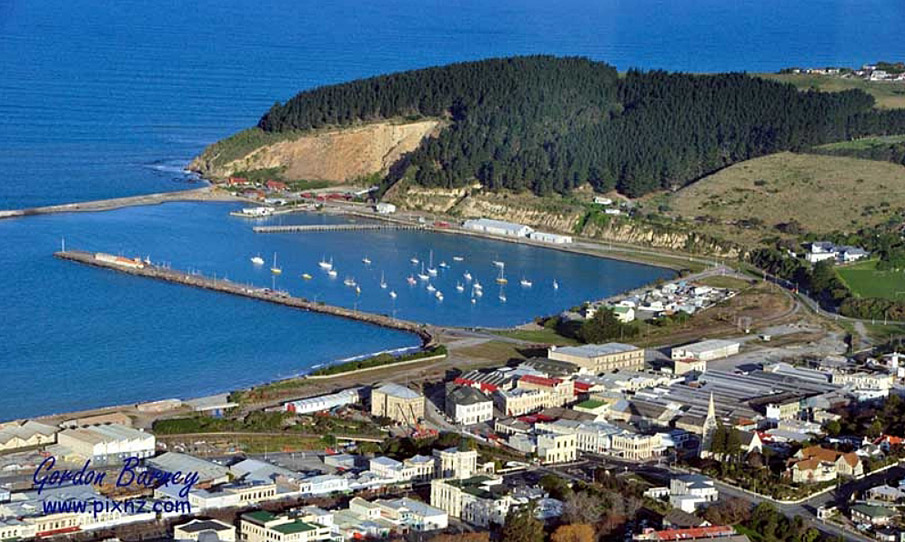
The Waitaki area is traditionally associated with the Kāhui-tipua, Te Rapuwai, Waitaha and Kāti Mamoe peoples. The land around the Waitaki River Mouth shows evidence of extensive settlement, while Moeraki was one of the early cradles of knowledge for Waitaha and Kāti Mamoe histories. Key coastal settlements were at Moeraki, Shag Point, Waikouaiti, and Huriawa (the Karitane Peninsula). Ngāi Tahu’s prehistoric presence is shown through a range of archaeological sites from middens and urupā, to rock art. Ngāi Tahu named the area in the lee of the cape, Ōamaru or the place of Maru, making use of the resources of the area. From the arrival of the Polynesian peoples to the 1940s, New Zealanders were ‘entirely dependent on sea transport for international trade and travel.’ The windy coast was a hazard to waka and European shipping alike. Coastal settlement Like other colonies such as Australia, European settlements in New Zealand were established on the coast. Settlements grew around natural harbours – such as Wellington, Dunedin, and Auckland. Also like Australia, other coastal settlements centred on land-based resources (gold, wool, or wheat, for example) which required coastal protection structures. Some settlements were based around river ports, which had a different set of difficulties, for example crossing the bar in places such as Westport. On exposed coasts with poor berthing facilities, ships had to unload close to shore at the roadstead vulnerable to sudden weather changes. Often, they would have to raise anchor and run for the open sea to avoid being driven ashore by strong winds or swells. New Zealand’s ‘crumpled’ landscape meant that road and rail networks were difficult to develop and a ‘myriad of little ports’ was the only way to connect settlements. Open coasts, such as those at New Plymouth, Napier, Timaru and Ōamaru, required specific structures to develop their harbours. In these unprotected places there was difficulty transferring cargo and passengers between ocean-going ships and the shore. Around these ports, road and rail transport networks spread inland. Engineering historian Michael Gourlay writes that in Australia nineteenth century coastal engineering was largely port and harbour engineering, and that the engineers were almost always British, and they were civil engineers, with experience in more than one field of public works. This was also the situation in New Zealand. Ōamaru developed in shelter of Cape Wanbrow to supply sheep stations. The Cape gave some protection from southerly winds, but was exposed to the prevailing north easterly. The first structure at Ōamaru was a derrick provided to haul goods up from the beach to the provincial government’s warehouse; this was followed by a flagstaff and some moorings at the bay. By 1860, with the beaching of the schooner Oamaru Lass, the dangers of the coast became clear. Engineer James Balfour designed an iron-piled L-shaped jetty near the end of Cape Wanbrow for the provincial government. The jetty was finished towards the end of 1867. The need for coastal protection: building a breakwater Ōamaru’s coast was notorious for drownings and shipwrecks. In one storm in July 1867 three ships were wrecked on the shore. McLean writes that ‘three ships resting unhappily on the beaches was a bad advertisement for Oamaru.’ Two weeks later the schooner Banshee was driven ashore, joining the other three ships. The unprotected jetty had a short life – a storm in February 1868 sank two wool ships and a coaster and mangled the new jetty. Locals demanded their own port, rejecting the provincial harbourmaster’s proposal to link, by rail, Ōamaru and his preferred port of Moeraki. The provincial government commissioned engineers Edward Dobson and John Blackett to report on port options. The engineers recommended building a small wet dock in the Brewery Lagoon (near where the Meek’s Grain Elevator building is today), the dock protected by seawalls running out from the end of the Cape. The Oamaru Dock Trust struggled with the project: Dobson and Blackett refused to oversee it, and engineer David Balfour who was their next choice, drowned off the coast of Timaru. John McGregor took over supervising the work. Walkem & Peyman, the contractors, started building concrete blocks for the south-east seawall in 1871. Money difficulties forced the Dock Trust to concentrate on the seawall rather than the dock. The first section was a 240 metre long breakwater. The breakwater had a rubble filled cavity between two rows of 4-high concrete blocks, which changed to solid concrete construction as the breakwater was extended further into the sea. The rock from the nearby harbour quarry was too weak to withstand the sea so concrete was essential. The cement was imported from Britain, the casks buried nearby as part of the associated reclamation. In 1873, a ‘massive rail-mounted steam travelling crane’ manufactured by Dunedin engineering firm Kincaid, McQueen & Co. provided the muscle for the project. The crane was the ‘largest full-slewing rail-mounted steam crane capable of travelling with a rated load anywhere in the world.’ The work was staged – it was often delayed by weather and became more difficult as the breakwater reached deeper waters. Divers were used to help level the seabed where the concrete blocks were to be placed. The most difficult part of the job was sinking the four caissons (watertight retaining structures) that were to form the seaward end of the breakwater. The caissons were floated to the end of the breakwater then filled with 600-700 tonnes of concrete and bound together with a concrete cap – making the head of the breakwater. It was February 1884 before the last caisson was in place. Detractors doubted that such a ‘juvenile excrescence’ was going to offer much competition to Dunedin’s preeminent position. But the Oamaruvian gentlemen had a dream; in a 1908 potted history of the port, the Otago Witness summed up (facetiously – given the financial problems) their vision: ‘Snuggled in around the corner formed by Cape Wanbrow and the East Coast they saw a great city; behind it, and to the south and north, miles and miles of fertile rolling plains stretched away, whereon grew wheat and oats and potatoes, sheep and cattle, in great confusion. All round they saw the vomiting smoke stacks of countless factories, and cosily berthed behind a big breakwater, many inter-ocean steams, filling capacious holds with the produce of North Otago….’ The advance of the breakwater allowed for the construction of wharves behind its protective walls. The first was the 46 metre Macandrew Wharf, completed against the landward end of the breakwater in 1875. The wharf meant passengers could disembark on solid ground rather than into a surfboat. Normanby Wharf was completed in 1878 and Cross Wharf in 1879. The wharves gave Ōamaru 370 metres of sheltered berths. Shipping accidents virtually ended. In 1879 Thomas Forrester, architect and secretary/engineer to the Oamaru Harbour Board, made trial bores and discovered the harbour could be dredged. This discovery opened the way to making Ōamaru a deepwater port, able to handle shipping from Britain. A large export wharf (Sumpter Wharf) was completed in 1884. The first ship to dock at Sumpter Wharf was Dunedin, the ship which had carried the first shipment of frozen meat from Dunedin in 1881. The second ship was the Elderslie, twice the size of the Dunedin, ‘the first frozen meat steamer for the New Zealand trade and initially intended to trade solely between Oamaru and London.’ It was the ports that created progress, jobs and business. Timaru and Ōamaru fought for their status in the 1880s. The construction of the breakwater and Macandrew Wharf at Ōamaru between 1871 and 1884 was vital to create a safe anchorage for ships along a notoriously dangerous coast. Its construction helped the town of Ōamaru prosper into the late-nineteenth century hub of North Otago. Historian Gavin McLean reports the envy of nearby Timaru: ‘A breakwater with a mole at the end of it, a wharf with a big hole dredged alongside, and what is more satisfactory. A big steamer lying in the big hole, loading up a huge cargo of mutton: all these things indicate progress, show a spirit of enterprise and auger well for the future prosperity of Ōamaru.’ McLean writes ‘[i]ronically, by the time the breakwater was finally capped off and Sumpter Wharf was lined with ships, the local economy had nose-dived. For some time the Long Depression had been settling over the colony and Oamaru’s growth spurt came to a sudden stop virtually at the same time as the mole, breakwater and Sumpter Wharf were finished and the grandest of the Harbour/Tyne Street precinct grain stores opened their doors. The town’s population would not regain its 1881 numbers until the 1920s.’ A further blow came with the major damage to the breakwater in August 1886, which tore a 100 metre gap at the outer end of the structure. The twentieth century Harbour developments did continue in the early years of the twentieth century. Holmes Wharf was built on top of the mole in 1906 to allow for the berthing of the new larger overseas ships. The harbour retained its trade into the 1930s. One of the Harbour Board’s major twentieth century projects was extending the breakwater. From as early as 1913, the board planned an angled extension to provide a sheltered shipping channel in deeper water. The extension was planned to be at an angle some two-thirds along the length of the breakwater. Lack of money meant the project was not undertaken until the 1930s. In 1933 engineer F.W. Furkert recommended a 280 metre extension as the first stage. In 1936 the Board used unemployed labour and rock from its own quarry to raise the breakwater along its landward end to provide a solid base for the new work. By the end of 1936 the Board began dumping rock for the Ramsay Extension. Work proceeded slowly – out 100 feet (30 metres) by 1937, to 140 feet (42.7 metres) in 1938 and to 205 feet in 1940 (62.5 metres). By 1942 the extension was 365 foot long. When the Oamaru Harbour Board sealed off the extension, it was 140 feet short of the original length and 520 feet short of Furkert’s recommendation. By 1944 the project was still incomplete and was abandoned. By the mid-1950s, the extension was disintegrating and also accelerating damage to the old breakwater. The port declined further as the Cook Strait road/rail ferries killed conventional shipping. In 1974, the last ship called at the harbour, and in 1978, the Oamaru Harbour Board was abolished, and the port closed to shipping. After a failed proposal to make Ōamaru a cement port in the 1980s, the harbour languished. Shoaling at the harbour entrance made it difficult for fishing boats to enter the port. Maintaining the breakwater, however, remained a significant expense. In early 1995, a dozen shipping containers were filled with concrete and placed along damaged sections of the breakwater. Later that year, the council agreed to keep the harbour open (through dredging) and to maintain the breakwater to protect the commercial area from erosion. The breakwater was damaged by severe storms in 2001. In 2005, 190 tetrapods were put around the damaged section of the breakwater, while armour rocks were placed on the outer edge. In the closing years of the twentieth century and in the first decade of the new century, Ōamaru Harbour underwent a revival with the building of the penguin viewing centre on harbour land at the landward end of the breakwater – the proximity to the breakwater making the structure a tourist attraction, adding to the area’s Victorian attractions. In 2004, the importance of Ōamaru’s harbour was recognised when it was included on the Heritage New Zealand List as an historic area. In 2017, the breakwater and Macandrew Wharf stand as reminders of the key role a sheltered harbour played in the development of this special Victorian town. As Gavin McLean writes, Ōamaru’s story is ‘exhilarating, epitomising the extraordinary vibrancy of coastal, colonial New Zealand.’
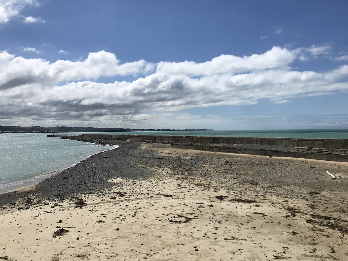
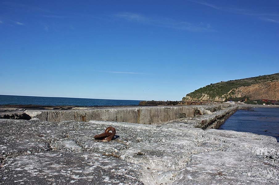
Coastal Protection The building of coastal defences, such as breakwaters, sea walls, groins and moles, has a long history. Such structures allowed for land to be stabilised or reclaimed and the sea to be tamed and harbours developed. In the nineteenth and twentieth centuries ‘coastal protection against an advancing sea has been on a variety of hard structures (groins, breakwaters, seawall, tetrapods, etc)…’ Current Description The Oamaru Harbour Breakwater is a ‘shore-parallel breakwater’ designed to ‘absorb and/or dissipate wave energy and thus prevent or reduce wave action on the lee side.’ It is a vertical type breakwater designed to protect against wave action – later additions have been added to the seaward side to further dissipate the wave energy. The concrete breakwater was built in stages, the different stages being evident in the structure. The uppermost section of the breakwater is the most recent; below it is the wider early section. Architect and engineering historian Geoffrey Thornton writes that the breakwater ‘consisted of two rows of concrete blocks each weighing some 25 tonnes. There were cross ties to form pockets filled with rubble from an adjacent quarry. The top surface was of concrete, about 2 m above extreme high tide.’ Thornton considers the breakwater a ‘major engineering work’ for its period. Rails ran along the top of the breakwater as shown by the timber sleepers projecting from the concrete on either side of the later portion. On the later portion the sleepers run straight down the top of the structure for around a quarter of its length. The remains of chains are spaced along the lee side of the breakwater, marking the length of Macandrew Wharf. Construction methods and chronology are evident in the surface of the concrete. A concrete ramp runs from the higher to the lower structure. A beacon stands at the tip of the breakwater. Tetrapods have been positioned on the seaward side of the breakwater to help protect the structure. Comparative Examples Ōamaru’s port facilities compare with New Zealand’s other ‘open coast’ ports: New Plymouth, Napier, and Timaru. Because these settlements had no sheltering harbour, their ports required specific structures to develop their harbours. In these unprotected places there was difficulty transferring cargo and passengers between ocean-going ships and the shore. A breakwater was the primary structure used to create shelter on such exposed coasts. According to engineering historian Nic MacArthur, the breakwater is an early example of concrete blocks used for the purposes of harbour protection, and its story links Oamaru to the international story of port and harbour technologies in the nineteenth century. Port Taranaki The port of New Plymouth was established in 1875. The construction of the main breakwater began in 1881. New Plymouth has been a ‘highly specialised port’ since 1983 when it was developed for the first cargoes from the methanol plant. For more detail of the history of the port see Gordon McLauchlan’s The Saltwater Highway: The Story of Ports & Shipping in New Zealand. As the image below shows, modern shipping has partially engulfed the historic structures (not listed). Port of Napier Napier was declared a Port of Entry in 1855, but it was not until 1875 that the Napier Harbour Board was created. The first port was at Ahuriri Spit, moving to the site beneath Bluff Hill in 1885. The foundation stone for the Napier Breakwater was laid on 14 January 1887. There have been changes to the Port of Napier reflecting its continued modernisation. In The port was badly damaged in the 1931 earthquake. The port was repaired and new facilities such as the port storage for the East Coast Farmers’ Fertiliser Company (1950), on-port pulp storage for Pan Pack Forest Products Ltd (1973) and in 1994 the opening of the port as a container depot. Port of Timaru The Cyclopedia provides detail of the Port of Timaru: ‘The harbour, as now constructed, is enclosed on the south-east side by a concrete breakwater, which was begun in October, 1878, and finished in December, 1887, under the supervision of Mr. F. W. Marchant. The breakwater is 30 feet wide at the top, and has been run out from the beach in a north-east by north direction for 1250 feet; trending then to the north by a six chain curve, it is continued for a further 1028 feet, making a total length of 2278 feet, exclusive of 150 feet of approaches. The cost of this work has been £219,518. On the north-east side the harbour is enclosed by a rubble wall 2400 feet long, the end of which is piled. The space enclosed is fifty acres, and the total expenditure on account of the construction of the breakwater, north wall, and wharves has been £281,000. Authority has been given to proceed with the construction of a rubble mole from the bend of the present breakwater in a north-easterly and northerly direction, to form an outer harbour. The proposed length of this mole is 3000 feet, and in July, 1903, it had been formed for a length of 1800 feet. Its beneficial effects have already been felt in the reduced range of the harbour, allowing of such vessels as the “Delphic,” “Tongariro,” “Essex,” and others to lie at the wharves in perfect safety. The cost of this addition to the end of 1902 was £82,000.’ Like the other ports still in commercial use, much of the historic layout (not listed) has been engulfed by modern port facilities. Ōamaru’s port (already recognised in its entirety as Oamaru Harbour Historic Area, List No. 7536) is of outstanding importance as New Zealand’s most intact Victorian/Edwardian port. Gavin McLean writes that ‘Oamaru Harbour remains the country’s best example of a Victorian/Edwardian export port. Bigger, more successful ports reconfigured themselves to gear up for the container age. Port Chalmers, for example, filled in its two graving docks and buried the old wooden finger piers beneath a massive reclamation for container handling and stacking. So did other ports as the size of ships took off and the demand for cargo storage climbed. Oamaru did not and still gives the appearance and scope of a colonial export port.’ Within the harbour area, the breakwater was the structure that allowed the rest to exist – without protection from the coastal surge and heavy seas, a port could not have developed, and Ōamaru would not have had the prominence that it did. As Gavin McLean writes, the Oamaru Harbour Board erected the breakwater which protected their ‘capitalist dreams’ from the ‘planet’s mightiest ocean.’ McLean argues that Ōamaru exemplifies ‘Everytown’ – ‘it exemplifies the ‘rush to be rich’ or the ‘progress industry’ that did more than warfare to reshape New Zealand’s destiny in the pivotal 1860s and 1870s.’ It is as geographer Kenneth Cumberland wrote ‘the archetypal rural servicing town, manufacturing centre and port.’
Coastal Protection The building of coastal defences, such as breakwaters, sea walls, groins and moles, has a long history. Such structures allowed for land to be stabilised or reclaimed and the sea to be tamed and harbours developed. In the nineteenth and twentieth centuries ‘coastal protection against an advancing sea has been on a variety of hard structures (groins, breakwaters, seawall, tetrapods, etc)…’ Current Description The Oamaru Harbour Breakwater is a ‘shore-parallel breakwater’ designed to ‘absorb and/or dissipate wave energy and thus prevent or reduce wave action on the lee side.’ It is a vertical type breakwater designed to protect against wave action – later additions have been added to the seaward side to further dissipate the wave energy. The concrete breakwater was built in stages, the different stages being evident in the structure. The uppermost section of the breakwater is the most recent; below it is the wider early section. Architect and engineering historian Geoffrey Thornton writes that the breakwater ‘consisted of two rows of concrete blocks each weighing some 25 tonnes. There were cross ties to form pockets filled with rubble from an adjacent quarry. The top surface was of concrete, about 2 m above extreme high tide.’ Thornton considers the breakwater a ‘major engineering work’ for its period. Rails ran along the top of the breakwater as shown by the timber sleepers projecting from the concrete on either side of the later portion. On the later portion the sleepers run straight down the top of the structure for around a quarter of its length. The remains of chains are spaced along the lee side of the breakwater, marking the length of Macandrew Wharf. Construction methods and chronology are evident in the surface of the concrete. A concrete ramp runs from the higher to the lower structure. A beacon stands at the tip of the breakwater. Tetrapods have been positioned on the seaward side of the breakwater to help protect the structure. Comparative Examples Ōamaru’s port facilities compare with New Zealand’s other ‘open coast’ ports: New Plymouth, Napier, and Timaru. Because these settlements had no sheltering harbour, their ports required specific structures to develop their harbours. In these unprotected places there was difficulty transferring cargo and passengers between ocean-going ships and the shore. A breakwater was the primary structure used to create shelter on such exposed coasts. According to engineering historian Nic MacArthur, the breakwater is an early example of concrete blocks used for the purposes of harbour protection, and its story links Oamaru to the international story of port and harbour technologies in the nineteenth century. Port Taranaki The port of New Plymouth was established in 1875. The construction of the main breakwater began in 1881. New Plymouth has been a ‘highly specialised port’ since 1983 when it was developed for the first cargoes from the methanol plant. For more detail of the history of the port see Gordon McLauchlan’s The Saltwater Highway: The Story of Ports & Shipping in New Zealand. As the image below shows, modern shipping has partially engulfed the historic structures (not listed). Port of Napier Napier was declared a Port of Entry in 1855, but it was not until 1875 that the Napier Harbour Board was created. The first port was at Ahuriri Spit, moving to the site beneath Bluff Hill in 1885. The foundation stone for the Napier Breakwater was laid on 14 January 1887. There have been changes to the Port of Napier reflecting its continued modernisation. In The port was badly damaged in the 1931 earthquake. The port was repaired and new facilities such as the port storage for the East Coast Farmers’ Fertiliser Company (1950), on-port pulp storage for Pan Pack Forest Products Ltd (1973) and in 1994 the opening of the port as a container depot. Port of Timaru The Cyclopedia provides detail of the Port of Timaru: ‘The harbour, as now constructed, is enclosed on the south-east side by a concrete breakwater, which was begun in October, 1878, and finished in December, 1887, under the supervision of Mr. F. W. Marchant. The breakwater is 30 feet wide at the top, and has been run out from the beach in a north-east by north direction for 1250 feet; trending then to the north by a six chain curve, it is continued for a further 1028 feet, making a total length of 2278 feet, exclusive of 150 feet of approaches. The cost of this work has been £219,518. On the north-east side the harbour is enclosed by a rubble wall 2400 feet long, the end of which is piled. The space enclosed is fifty acres, and the total expenditure on account of the construction of the breakwater, north wall, and wharves has been £281,000. Authority has been given to proceed with the construction of a rubble mole from the bend of the present breakwater in a north-easterly and northerly direction, to form an outer harbour. The proposed length of this mole is 3000 feet, and in July, 1903, it had been formed for a length of 1800 feet. Its beneficial effects have already been felt in the reduced range of the harbour, allowing of such vessels as the “Delphic,” “Tongariro,” “Essex,” and others to lie at the wharves in perfect safety. The cost of this addition to the end of 1902 was £82,000.’ Like the other ports still in commercial use, much of the historic layout (not listed) has been engulfed by modern port facilities. Ōamaru’s port (already recognised in its entirety as Oamaru Harbour Historic Area, List No. 7536) is of outstanding importance as New Zealand’s most intact Victorian/Edwardian port. Gavin McLean writes that ‘Oamaru Harbour remains the country’s best example of a Victorian/Edwardian export port. Bigger, more successful ports reconfigured themselves to gear up for the container age. Port Chalmers, for example, filled in its two graving docks and buried the old wooden finger piers beneath a massive reclamation for container handling and stacking. So did other ports as the size of ships took off and the demand for cargo storage climbed. Oamaru did not and still gives the appearance and scope of a colonial export port.’ Within the harbour area, the breakwater was the structure that allowed the rest to exist – without protection from the coastal surge and heavy seas, a port could not have developed, and Ōamaru would not have had the prominence that it did. As Gavin McLean writes, the Oamaru Harbour Board erected the breakwater which protected their ‘capitalist dreams’ from the ‘planet’s mightiest ocean.’ McLean argues that Ōamaru exemplifies ‘Everytown’ – ‘it exemplifies the ‘rush to be rich’ or the ‘progress industry’ that did more than warfare to reshape New Zealand’s destiny in the pivotal 1860s and 1870s.’ It is as geographer Kenneth Cumberland wrote ‘the archetypal rural servicing town, manufacturing centre and port.’
Historical and Associated Iwi / Hapū / Whānau
Public NZAA Number
J41/284
Completion Date
14th May 2018
Report Written By
Heather Bauchop
Information Sources
McLean, 1982
Gavin McLean, Oamaru Harbour: Port in a Storm, Palmerston North, 1982
McLean, 2008
Gavin McLean, Kiwitown’s Port: The Story of Oamaru Harbour, Otago University Press, Dunedin, 2008.
Other Information
Please note that entry on the New Zealand Heritage List/Rārangi Kōrero identifies only the heritage values of the property concerned, and should not be construed as advice on the state of the property, or as a comment of its soundness or safety, including in regard to earthquake risk, safety in the event of fire, or insanitary conditions. Archaeological sites are protected by the Heritage New Zealand Pouhere Taonga Act 2014, regardless of whether they are entered on the New Zealand Heritage List/Rārangi Kōrero or not. Archaeological sites include ‘places associated with pre-1900 human activity, where there may be evidence relating to the history of New Zealand’. This List entry report should not be read as a statement on whether or not the archaeological provisions of the Act apply to the property (s) concerned. Please contact your local Heritage New Zealand office for archaeological advice. A fully referenced New Zealand Heritage List report is available on request from the Otago/Southland Office of Heritage New Zealand
Current Usages
Uses: Transport
Specific Usage: Breakwater
Uses: Transport
Specific Usage: Wharf/Dock/ Pier/ Jetty
Former Usages
General Usage: Transport
Specific Usage: Breakwater
Web Links
description: Signs up to make clear no public access to breakwater / ODT
url: https://www.odt.co.nz/regions/north-otago/signs-make-clear-no-public-access-breakwater
Stay up to date with Heritage this month
