

Flour milling was a widespread industry in nineteenth century New Zealand, turning wheat into flour. Milling became centred on the climate most suited to it – North Otago, South Canterbury and eastern Southland. In Otepopo, a small settlement south of Oamaru, the first mill was built on the Otepopo River (now known as the Waianakarua River) in 1870 – Louis Schmoll’s Fernyhaugh Flour Mill. The history of this mill illustrates some of the risks in establishing such a business, in a dramatic way.
Louis Schmoll (d.1889) was a German miller. He came to New Zealand with his wife and child in 1865 as an assisted immigrant. By 1870 he had moved to Oamaru where he worked at Hassell’s flour mill. Schmoll planned to erect his own mill at Otepopo on land leased from George Fenwick, and in February 1870 advertised his intentions, calling his mill-to-be the Fernyhaugh Flour Mill. There followed a rash of trouble – a conspiracy trial (did Schmoll’s business partners conspire to burn down the mill for the insurance money), a perjury trial (did Schmoll lie about the conspiracy, bankruptcy (of Schmoll, his business partners, and a subsequent owner), local competition, and ultimately failure. The mill (later known as Otepopo Flour Mill and the Atlas Flour Mill) was closed by 1880.
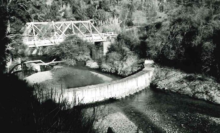
The mill site on Waianakarua River consists of the mill dam and the foundations of the water wheel located 20 metres below the dam. The dam is semi-circular and built of limestone and some 1.5 metres thick. The foundations consist of a concrete block set into the river bed, and a concrete and schist platform built up against the east river bank. The wheel was originally mounted between these structures. The mill building was located on a flat terrace above the true left of the river. No above ground evidence remains of the mill building. A cutting into the bedrock with stone steps formed an access-way to the waterwheel foundations and platform.
When archaeologist Jill Hamel visited the site in 1998, she described the dam has having a row of heavy bolts along the centre, perhaps indicating an additional structure. A local resident told Hamel that when she first saw the dam there had been steel stanchions about three feet high, and she had assumed that there had been a weir gate on top of the dam.
In the years following its closure, the mill became a picturesque ruin. The site of the mill was a popular picnic spot and historic attraction. In the 1980s the mill dam was restored and interpreted as a 1990 project. In 2016, the mill site, popularly known as Grave’s Dam, remains a significant reminder of the importance and risk of running a nineteenth century flour mill.
List Entry Information
Status
Listed
List Entry Status
Historic Place Category 2
Access
Able to Visit
List Number
5188
Date Entered
17th September 1992
Date of Effect
17th September 1992
City/District Council
Waitaki District
Region
Otago Region
Extent of List Entry
Extent includes part of the land described as Legal River and the structures associated with Fernyhaugh Flour Mill Site (Former), thereon. Refer to the extent map tabled at the Rarangi Korero Committee meeting on 9 March 2017.
Legal description
Legal River, Otago Land District
Why is this place significant?
Historic Significance
Historical Significance or Value Grave's Dam serves as a visible reminder of the significant contribution made to the nineteenth-century economy of North Otago by the milling industry and of James Grave's involvement in that industry in addition to his other business concerns.
Physical Significance
ARCHITECTURAL QUALITY: Grave's Dam is thought to be unique in this country because of the semicircular shape of its masonry structure (G.G. Thornton, assessment of significance, October 1990). "The use of the arch dam by Graves (sic), here curved in plan although vertical in section, suggests a grasp of engineering technology as the arch form is generally superior to the straight line in dam construction" (Ibid.). Although water-powered flour mills were quite common in nineteenth-century New Zealand they were usually powered by water brought to the water-wheel on fluming and only rarely fed by water from a mill pond, which had been created by a dam, as at Grave's dam. Another flour mill on the same branch of the Waianakarua River, built by Diehl and Davidson in 1879, was also served by a mill pond, formed by a concrete dam, but the latter is no long extant. TOWNSCAPE/LANDMARK VALUE: Set within a picturesque landscape setting, and easily viewed from the bridge which carries Breakneck Road over the Waianakarua River, Grave's Dam has considerable landmark value within its immediate environment.
Construction Professional
Name
James Calder
Type
Builder
Biography
No biography is currently available for this construction professional
Name
Schmoll, Louis
Type
Engineer
Biography
A German engineer called Louis Schmoll built the Graves dam over Waianakarua River which James Grave (c.1846-1906) remodelled in 1873.
Name
McGregor, John
Type
Engineer
Biography
http://www.ipenz.org.nz/heritage/bio-detail.cfm?id=62
Construction Details
Start Year
1870
Type
Original Construction
Description
Schmoll’s Fernyhaugh Flour Mill constructed
Start Year
1986
Type
Modification
Description
Installation of concrete abutments.
Start Year
1873
Type
Modification
Description
Grave and McIntosh remodel the mill
Start Year
1874
Type
Modification
Description
Dam level raised
Type
Other
Description
Mill closed
Period
prior to 1880
Construction Materials
Totara limestone, cement mortar, steel and concrete.
Notable Features
The shape and structure of the dam are its most outstanding features.
Flour milling was a widespread industry in nineteenth century New Zealand, turning wheat into flour. Milling became centred on the climate most suited to it – North Otago, South Canterbury and eastern Southland. In these areas many mills were established, the earliest using water power – the mechanism of the mill stones driven by a water wheel, and later mills using steam power. Early mills in North Otago included Clark’s Mill at Maheno and others such as Meek’s Flour Mill in Oamaru itself. In Otepopo, a small settlement south of Oamaru, the first mill was built on the Otepopo River (now known as the Waianakarua River) in 1870 – Louis Schmoll’s Fernyhaugh Flour Mill. Louis Schmoll (d.1889) was a German miller. He came to New Zealand with his wife and child in 1865 as an assisted immigrant. By 1870 he had moved to Oamaru where he worked at Hassell’s flour mill. Schmoll planned to erect his own mill at Otepopo on land leased from George Fenwick, and in February 1870 advertised his intentions, calling his mill-to-be the Fernyhaugh Flour Mill. Schmoll over-extended himself and by the middle of the year was in financial difficulty filing for bankruptcy in August 1870, and was adjudged bankrupt a month later. Matters worsened in October 1870 with a conspiracy case before the court – which usefully provides detail about the mill and about Schmoll himself. In his evidence Schmoll indicates he had been at Otepopo for seven or eight months and had leased land from George Fenwick for purposes of erecting a timber flour mill. He describes the mill as ‘nearly finished.’ Schmoll had purchased timber from Otepopo farmer James Gilham (variously Gilam) and George Cooper – who were partners in the enterprise. Schmoll accused Gilham and Cooper with conspiracy to burn down the mill in an attempt to recover insurance monies to get them out of financial difficulties. The case attracted the papers and was covered in detail. Schmoll himself was aware of the apparent plan to burn down the mill and claim the insurance, but claimed not to have agreed to the plan. The plan was thwarted by a bailiff taking possession of the mill. The magistrate, after hearing evidence, believed that there was insufficient evidence to bring the case to trial and the prisoners were discharged. Schmoll was then himself charged with having committed perjury, acting with malice in accusing Cooper and Gilham with conspiracy. A jury found Schmoll not guilty. Meanwhile, the trustees of Schmoll’s estate offered the lease of the Fernyhaugh Mill describing the ‘valuable premises, comprising a large water-power mill, machinery, plant &c. Also, a convenient cottage.’ The mill was still incomplete with agents Sumpter and Lemon advertising for a partner (with available capital) to ‘complete the ERECTION OF A WATER MILL – wheel and most of the machinery on the ground.’ There was also sufficient water power to drive a pair of stones. In April 1871 Frederick Luhning advertised the ‘Otepopo Mills’ as ready for receiving wheat for grinding in May. Schmoll continued to work at the mill – he was injured in an accident at the mill in May 1871, and this was reported in the newspaper. Luhning was a businessman who had interests in Queenstown and Dunedin. He was variously described as a miller, wholesale tobacconist and bootmaker. In May 1871, engineer John Hardy advertised for the erection of a ‘Stone Kiln’ at the Otepopo Mills for Luhning. This is presumably an oatmeal kiln. Luhning himself got into financial difficulties and the mill was again offered for sale along with 16 acres of freehold land. A sale notice in March 1872 described the mill as capable of driving three pairs of stones. By 1872, the mill was in the hands of Spence and Grave, who ran the Phoenix Mill further down the river, who intended to add sawmilling to their operation. The partnership changed to James Grave and James McIntosh, who advertised themselves as cash buyers of wheat for the Otepopo Flour Mills in January 1873. Captain James Grave owned eight sailing ships that worked the Pacific waters. He was an Oamaru town councillor as well as carrying on business as a merchant and having an interest in this flour mill. He went overseas and died in Perth. An 1873 article indicates that Grave and McIntosh remodelled the mill – and were at that time in the process of erecting two pairs of stones. The writer thought the mill in a poor position but that that might be counterbalanced by the water power. The writer feared that the river could rise on short notice and ‘sweep the wheel away, although it is secured to a large concrete pier embedded in the rock.’ The mill’s proximity to the new railway might also be to its advantage. Court cases followed the mill again in 1873 when James Calder unsuccessfully sued Grave and McIntosh for breach of promise over work at the mill. Grave and McIntosh had asked Calder to look at the mill dam and where they wanted the piers put. Donald Douglas drew a sketch of the piers (wooden beams set on end). After experiencing the rapid rise of the river, Calder and the miller James Davidson, agreed that the best idea would be to build an entirely new dam. To this, Grave and Ogilvie agreed. After flooding delayed work, Calder built a new dam, the work taking a couple of weeks. The Otago Daily Times reported the operation of Graves and Mcintosh’s ‘new water power flour mill’ at Otepopo in June 1873. The article mentions the modern machinery and the expense in constructing the mill which included a new road to avoid having to cross the river twice. The writer mentions that the owners contemplated ‘the raising of the dam, in order to obtain additional power’ which would give the mill the capacity to turn out 40 tons of flour a week. The proprietors also proposed to erect ‘additional machinery, and to include the manufacture of oatmeal.’ The dam ‘in the course of erection’ was damaged by flooding, owing to the cement not having set, three courses of stone were displaced and had to be repaired. The river would similarly damage Diehl and Davidson’s mill dam further downriver in 1879. The renovated ‘Atlas Flourmills’ are described in November 1873: ‘The mill property comprises the mill, miller’s house, men’s houses, stables etc.’ and the dam, the wall of which is 6 feet in diameter, and 20 feet high; and is closed and faced with Portland cement; the back is now being filled with earth and gravel. From the dam is obtained a fall of 13ft. for the sluicehead. The mill is worked with a breast wheel which is 22ft. in diameter, and is enclosed between concrete walls, the main shaft works in a tunnel cut in the rock foundations of the mill.’ The mill, with its two pairs of stones, put out fifty tons of flour a week. In March 1874 Grave and McIntosh advertised for tenders for ‘additions and alterations to the Atlas Mill Dam’ across the Otepopo River. In August of the same year, engineer John McGregor invited tenders for ‘Forming the Puddle Embankment, and other works required at the Atlas Mill Dam’ for James Grave. The mill apparently closed sometime before 1881. In discussing the fire at Diehl and Davidson’s mill downriver from the Atlas Mill, the Otago Witness records that there were three mills erected in this locality and two had burnt down. The remaining mill, the Atlas had been ‘closed for some years.’ The mill and dam were a picturesque excursion for locals. The Oamaru Woollen Factory picnic was held nearby in 1897, recognising the scenic value of the place. An article in 1902 describes an outing to the river where ‘the remains of the old mill and the dam across the river, too, added a certain amount of historical interest to the place.’ The Trades Picnic Committee voted to hold their picnic on the old mill site in 1907. Some of the land close to the mill was subdivided for holiday residences as early as 1910. The Waitaki County Council had plans to bridge the river near the old mill in 1911, noting the solid rock bound approaches and long span required to reach across the deep gully. Over the years, the site became a ruin. In 1985 archaeologist and James Grave’s great grandson Karl Gillies recorded the dam and flour mill remains (naming them Grave’s Dam) as an archaeological site under the New Zealand Archaeological Association Site Recording Scheme. In the years following its closure, the mill became a picturesque ruin. The site of the mill was a popular picnic spot and historic attraction. In the 1980s the mill dam was restored and interpreted as a 1990 project. In 2016, the dam and flour mill remains are a notable historic site in North Otago, with an interpretation panel describing their history.
Flour milling was a widespread industry in nineteenth century New Zealand, turning wheat into flour. Milling became centred on the climate most suited to it – North Otago, South Canterbury and eastern Southland. In these areas many mills were established, the earliest using water power – the mechanism of the mill stones driven by a water wheel, and later mills using steam power. Early mills in North Otago included Clark’s Mill at Maheno and others such as Meek’s Flour Mill in Oamaru itself. In Otepopo, a small settlement south of Oamaru, the first mill was built on the Otepopo River (now known as the Waianakarua River) in 1870 – Louis Schmoll’s Fernyhaugh Flour Mill. Louis Schmoll (d.1889) was a German miller. He came to New Zealand with his wife and child in 1865 as an assisted immigrant. By 1870 he had moved to Oamaru where he worked at Hassell’s flour mill. Schmoll planned to erect his own mill at Otepopo on land leased from George Fenwick, and in February 1870 advertised his intentions, calling his mill-to-be the Fernyhaugh Flour Mill. Schmoll over-extended himself and by the middle of the year was in financial difficulty filing for bankruptcy in August 1870, and was adjudged bankrupt a month later. Matters worsened in October 1870 with a conspiracy case before the court – which usefully provides detail about the mill and about Schmoll himself. In his evidence Schmoll indicates he had been at Otepopo for seven or eight months and had leased land from George Fenwick for purposes of erecting a timber flour mill. He describes the mill as ‘nearly finished.’ Schmoll had purchased timber from Otepopo farmer James Gilham (variously Gilam) and George Cooper – who were partners in the enterprise. Schmoll accused Gilham and Cooper with conspiracy to burn down the mill in an attempt to recover insurance monies to get them out of financial difficulties. The case attracted the papers and was covered in detail. Schmoll himself was aware of the apparent plan to burn down the mill and claim the insurance, but claimed not to have agreed to the plan. The plan was thwarted by a bailiff taking possession of the mill. The magistrate, after hearing evidence, believed that there was insufficient evidence to bring the case to trial and the prisoners were discharged. Schmoll was then himself charged with having committed perjury, acting with malice in accusing Cooper and Gilham with conspiracy. A jury found Schmoll not guilty. Meanwhile, the trustees of Schmoll’s estate offered the lease of the Fernyhaugh Mill describing the ‘valuable premises, comprising a large water-power mill, machinery, plant &c. Also, a convenient cottage.’ The mill was still incomplete with agents Sumpter and Lemon advertising for a partner (with available capital) to ‘complete the ERECTION OF A WATER MILL – wheel and most of the machinery on the ground.’ There was also sufficient water power to drive a pair of stones. In April 1871 Frederick Luhning advertised the ‘Otepopo Mills’ as ready for receiving wheat for grinding in May. Schmoll continued to work at the mill – he was injured in an accident at the mill in May 1871, and this was reported in the newspaper. Luhning was a businessman who had interests in Queenstown and Dunedin. He was variously described as a miller, wholesale tobacconist and bootmaker. In May 1871, engineer John Hardy advertised for the erection of a ‘Stone Kiln’ at the Otepopo Mills for Luhning. This is presumably an oatmeal kiln. Luhning himself got into financial difficulties and the mill was again offered for sale along with 16 acres of freehold land. A sale notice in March 1872 described the mill as capable of driving three pairs of stones. By 1872, the mill was in the hands of Spence and Grave, who ran the Phoenix Mill further down the river, who intended to add sawmilling to their operation. The partnership changed to James Grave and James McIntosh, who advertised themselves as cash buyers of wheat for the Otepopo Flour Mills in January 1873. Captain James Grave owned eight sailing ships that worked the Pacific waters. He was an Oamaru town councillor as well as carrying on business as a merchant and having an interest in this flour mill. He went overseas and died in Perth. An 1873 article indicates that Grave and McIntosh remodelled the mill – and were at that time in the process of erecting two pairs of stones. The writer thought the mill in a poor position but that that might be counterbalanced by the water power. The writer feared that the river could rise on short notice and ‘sweep the wheel away, although it is secured to a large concrete pier embedded in the rock.’ The mill’s proximity to the new railway might also be to its advantage. Court cases followed the mill again in 1873 when James Calder unsuccessfully sued Grave and McIntosh for breach of promise over work at the mill. Grave and McIntosh had asked Calder to look at the mill dam and where they wanted the piers put. Donald Douglas drew a sketch of the piers (wooden beams set on end). After experiencing the rapid rise of the river, Calder and the miller James Davidson, agreed that the best idea would be to build an entirely new dam. To this, Grave and Ogilvie agreed. After flooding delayed work, Calder built a new dam, the work taking a couple of weeks. The Otago Daily Times reported the operation of Graves and Mcintosh’s ‘new water power flour mill’ at Otepopo in June 1873. The article mentions the modern machinery and the expense in constructing the mill which included a new road to avoid having to cross the river twice. The writer mentions that the owners contemplated ‘the raising of the dam, in order to obtain additional power’ which would give the mill the capacity to turn out 40 tons of flour a week. The proprietors also proposed to erect ‘additional machinery, and to include the manufacture of oatmeal.’ The dam ‘in the course of erection’ was damaged by flooding, owing to the cement not having set, three courses of stone were displaced and had to be repaired. The river would similarly damage Diehl and Davidson’s mill dam further downriver in 1879. The renovated ‘Atlas Flourmills’ are described in November 1873: ‘The mill property comprises the mill, miller’s house, men’s houses, stables etc.’ and the dam, the wall of which is 6 feet in diameter, and 20 feet high; and is closed and faced with Portland cement; the back is now being filled with earth and gravel. From the dam is obtained a fall of 13ft. for the sluicehead. The mill is worked with a breast wheel which is 22ft. in diameter, and is enclosed between concrete walls, the main shaft works in a tunnel cut in the rock foundations of the mill.’ The mill, with its two pairs of stones, put out fifty tons of flour a week. In March 1874 Grave and McIntosh advertised for tenders for ‘additions and alterations to the Atlas Mill Dam’ across the Otepopo River. In August of the same year, engineer John McGregor invited tenders for ‘Forming the Puddle Embankment, and other works required at the Atlas Mill Dam’ for James Grave. The mill apparently closed sometime before 1881. In discussing the fire at Diehl and Davidson’s mill downriver from the Atlas Mill, the Otago Witness records that there were three mills erected in this locality and two had burnt down. The remaining mill, the Atlas had been ‘closed for some years.’ The mill and dam were a picturesque excursion for locals. The Oamaru Woollen Factory picnic was held nearby in 1897, recognising the scenic value of the place. An article in 1902 describes an outing to the river where ‘the remains of the old mill and the dam across the river, too, added a certain amount of historical interest to the place.’ The Trades Picnic Committee voted to hold their picnic on the old mill site in 1907. Some of the land close to the mill was subdivided for holiday residences as early as 1910. The Waitaki County Council had plans to bridge the river near the old mill in 1911, noting the solid rock bound approaches and long span required to reach across the deep gully. Over the years, the site became a ruin. In 1985 archaeologist and James Grave’s great grandson Karl Gillies recorded the dam and flour mill remains (naming them Grave’s Dam) as an archaeological site under the New Zealand Archaeological Association Site Recording Scheme. In the years following its closure, the mill became a picturesque ruin. The site of the mill was a popular picnic spot and historic attraction. In the 1980s the mill dam was restored and interpreted as a 1990 project. In 2016, the dam and flour mill remains are a notable historic site in North Otago, with an interpretation panel describing their history.
The mill site on Waianakarua River consists of the mill dam and the foundations of the water wheel located 20 metres below the dam. The dam is semi-circular and built of limestone and some 1.5 metres thick. The foundations consist of a concrete block set into the river bed, and a concrete and schist platform built up against the east river bank. The wheel was originally mounted between these structures. The mill building was located on a flat terrace above the true left of the river. No above ground evidence remains of the mill building. A cutting into the bedrock with stone steps formed an access-way to the waterwheel foundations and platform. When archaeologist Jill Hamel visited the site in 1998, she described the dam has having a row of heavy bolts along the centre, perhaps indicating an additional structure. A local resident told Hamel that when she first saw the dam there had been steel stanchions about three feet high, and she had assumed that there had been a weir gate on top of the dam.
The mill site on Waianakarua River consists of the mill dam and the foundations of the water wheel located 20 metres below the dam. The dam is semi-circular and built of limestone and some 1.5 metres thick. The foundations consist of a concrete block set into the river bed, and a concrete and schist platform built up against the east river bank. The wheel was originally mounted between these structures. The mill building was located on a flat terrace above the true left of the river. No above ground evidence remains of the mill building. A cutting into the bedrock with stone steps formed an access-way to the waterwheel foundations and platform. When archaeologist Jill Hamel visited the site in 1998, she described the dam has having a row of heavy bolts along the centre, perhaps indicating an additional structure. A local resident told Hamel that when she first saw the dam there had been steel stanchions about three feet high, and she had assumed that there had been a weir gate on top of the dam.
Historical and Associated Iwi / Hapū / Whānau
Public NZAA Number
J42/42
Completion Date
26th January 2017
Report Written By
Heather Bauchop
Information Sources
McDonald, 1962
K C McDonald, 'White Stone Country', Oamaru, 1962
Oamaru Mail
22 Mar 1882, p. 2.
Otago Daily Times
Otago Daily Times, 1 Jun 1915, p.10.
Thornton, 1982
Geoffrey G. Thornton, New Zealand's Industrial Heritage, A.H. & A.W. Reed, Wellington, 1982
Roberts, 1934
Beginnings: Early History of North Otago [a reprint of 'History of North Otago' published in 1934], The Oamaru Mail Co. Ltd, Oamaru, 1978
Petchey, 2007
Peter Petchey, ‘Breakneck Road Bridge: Archaeological Assessment of Breakneck Road Bridge over the Waianakarua River, North Otago,’ Southern Archaeology, 2007
Williams and Middleton, 2012
Hamish Williams and Angela Middleton, ‘Breakneck Road Bridge: Final report to NZHPT and Waitaki District Council on Archaeological Authority No. 2010/126,’ Arch Hill Heritage Report No. 115, September 2012
Other Information
This historic place was registered under the Historic Places Act 1980. Please note that entry on the New Zealand Heritage List/Rarangi Korero identifies only the heritage values of the property concerned, and should not be construed as advice on the state of the property, or as a comment of its soundness or safety, including in regard to earthquake risk, safety in the event of fire, or insanitary conditions. A fully referenced upgrade report is available on request from the Otago/Southland Office of Heritage New Zealand.
Former Usages
General Usage: Manufacturing
Specific Usage: Flour/grain mill
General Usage: Utilities
Specific Usage: Reservoir/ Dam
Former Usages
General Usage: Manufacturing
Specific Usage: Flour/grain mill
General Usage: Utilities
Specific Usage: Reservoir/ Dam
Location
Stay up to date with Heritage this month
