

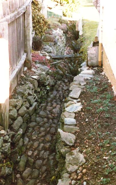
This stone-lined channel on a section of land declared part of a water reserve in the 1870s was probably built in the late 1870s or early 1880s to help control water flow from springs and streams on this sloping land on Hallenstein Street, Queenstown. It has historical and archaeological significance. In November 1873, the sections associated with the channel were included as part of a ‘water reserve.’ On an 1871 survey plan these sections show what appears to be a stream bed marked as a water reserve traversing these land parcels. These water ways appear to travel down the slope, rather than traverse it as would be typical of a water race, so it looks like the structure is associated with managing the flow of the water, rather than carrying water as a race would do. The council leased the water reserve sections on a ten year term. The Municipal Council did use stone to line such channels as there is a reference in the Works Committee report for June 1887, where the Council paid Mr McMullin £2 to ‘utilise stones and finish the pitching of a channel in [the] water reserve.’ In 1898, a lease advertisement notes the ‘water channel running through these sections’ was to be ‘kept clear of obstructions by the tenant.’ Mr McMullin was the existing tenant, so it is possible he lined the channel with stones through this section. The bottom and the sides of the water race are lined with rounded stones, probably used to ripple the flow to prevent scouring. The channel was being used as late as 1940. A Matthew Hyndman wrote to the council drawing their attention to the ‘damage caused by storm water from the council’s property’ on Queenstown hill. He wrote that the ‘conditions constitute a perennial nuisance which could be inexpensively dealt with at the source. Two or three men working under intelligent supervision could deflect most of the dangerous surface riverlets into their legitimate channel in York Street’ [the course of the stream above Hallenstein Street]. There is a common view that the stone lined channel was a water race associated with Buckham’s Brewery, but this does not appear to be the case. For example, according to John Heenan writing in the Queenstown Courier, this water race was constructed around 1871 to supply water to a brewery established on Marine Parade, and would have also provided adjacent property owners with access to water. Heenan writes that the race was probably used until the piped supply was brought down from One Mile Stream as the town water supply. The improvement in the water supply was motivated by the Ballarat Street fire in 1882 where the bucket supply from the lake proved inadequate for fire-fighting. Once the town supply was established, the race became more of a drain, and was still running in the 1950s. Heenan writes that problems with flooding were linked to the race, so the supply was cut off, and much of the race filled in. Long-time owner of the property, Margaret Templeton, calls the feature a ‘cobbled creek bed’. Other correspondence from the 1980s identifies it as a ‘Stone Channel.’ The channel was described as running ‘down the boundary of my property’ and Mrs Templeton said it ‘could be a water race.’ The Templetons preserved their 50 metre section and had a plaque installed commemorating its importance. Much of the channel has been buried or destroyed, but this remaining section illustrates the stone-lined construction of the original channel. In 2016, the Stone-lined Channel remains, as does the plaque commemorating its existence.
Location
List Entry Information
Overview
Detailed List Entry
Status
Listed
List Entry Status
Historic Place Category 2
Access
Private/No Public Access
List Number
5224
Date Entered
4th April 1990
Date of Effect
4th April 1990
City/District Council
Queenstown-Lakes District
Region
Otago Region
Extent of List Entry
Extent includes part of the land described as Sec 12 Blk XXXV Town of Queenstown (RT OT3D/43), Otago Land District, and the structure known as the Stone-lined Channel thereon, as shown on the extent map tabled at the Rārangi Kōrero Committee meeting on 2 June 2016.
Legal description
Sec 12 Blk XXXV Town of Queenstown (RT OT3D/43), Otago Land District
Stay up to date with Heritage this month
