

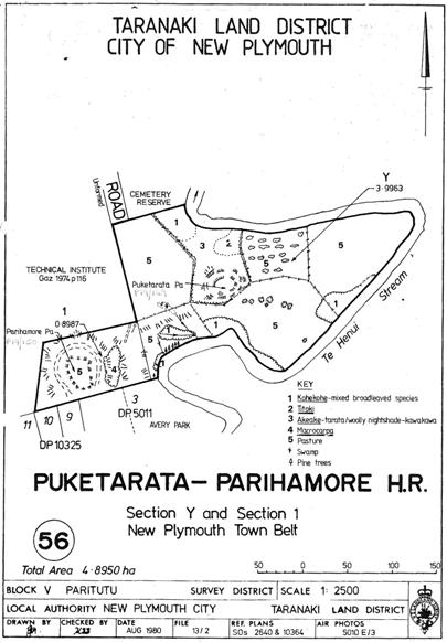
Parihamore Pā, located on the banks of the Te Henui Stream in New Plymouth, was part of a complex of strategically important Te Ātiawa pā within Ngāti Te Whiti’s rohe. This pā has archaeological and traditional significance connected with Māori settlement of the area. It also has historic importance because it is associated with several notable eighteenth century Taranaki rangatira. Te Ātiawa hapu occupied the area in and around what became New Plymouth for generations before European settlement began. One settlement was at Parihamore Pā, which commanded good views along the Te Henui Stream valley and is said to have been ‘a strong place in its time, though not very large’. Together with nearby Puketarata (Category 2 historic place, List No. 5968) and Pukewharangi Pā, these fortified settlements formed a defensive network. Aside from being close to the stream, which provided water, eels, and efficient access to the sea, Parihamore was also surrounded by swamp and bushland which provided other important resources for the community. The area around Parihamore was also cultivated in the late eighteenth century, when Whakamoumou-rangi was chief. During this period the pā was home to a particularly fruitful titoki tree, which was well-known locally. Oil from its berries was used as perfume. A notable beauty also lived at Parihamore - Uru-kinaki, chief Kahu-taia’s daughter. Such was her renown that another local chief, Potaka, laid siege to the pā until Uru-kinaki agreed to become his wife. European settlement in New Plymouth began in earnest when New Zealand Company settlers arrived in 1841. The pā site was later surveyed as part of the Town Belt – an area which functioned as a transitional zone between the town and rural areas. Like its counterparts around the country, the New Plymouth’s Town Belt was used for grazing and as a recreational space. As such, there has been some stock erosion at the grass covered pā site. Discernible earthworks features include perimeter ditches, terracing and pits. It was described in 1962 as ‘a pa of some size of the typical North Taranaki headland type’. In particular, archaeologist Nigel Prickett has noted that the defensive bank at the platform’s southern end, a characteristic feature of this type of Taranaki pā, is ‘seldom so distinctive’. Parihamore Pā became part of the Puketarata Parihamore Historic Reserve in 1982. The pā is a feature of Te Ara Puawai o Te Henui Walkway, a recreation route connecting aspects within the city’s Māori and early settler cultural and historic landscape, including Te Henui Vicarage, Category 1 historic place (List No. 892). In recognition of Parihamore Pā’s importance to iwi, under the terms of the 2014 Treaty of Waitangi Settlement an overlay classification was placed on the pā’s Historic Reserve which involves Te Ātiawa in the management of the site.

Location
List Entry Information
Overview
Detailed List Entry
Status
Listed
List Entry Status
Historic Place Category 2
Access
Able to Visit
List Number
5969
Date Entered
6th June 1985
Date of Effect
6th June 1985
City/District Council
New Plymouth District
Region
Taranaki Region
Extent of List Entry
Extent includes the land described as Sec 1 New Plymouth Town Belt SO 10364 (NZ Gazette 1982, p.4253), Taranaki Land District, and the archaeological site known as Parihamore Pā (NZAA P19/150) thereon, as shown on the location map appended to the notification letter dated 20 June 1985.
Legal description
Sec 1 New Plymouth Town Belt SO 10364 (NZ Gazette 1982, p.4253), Taranaki Land District
Stay up to date with Heritage this month
