

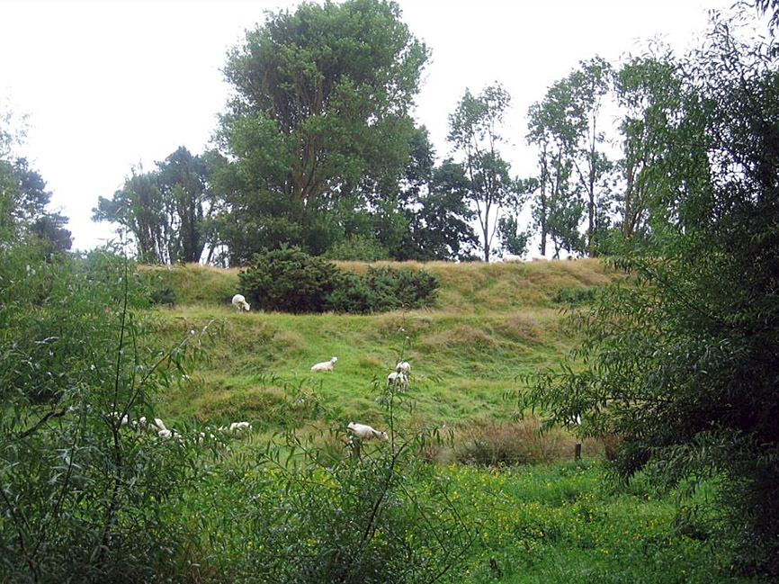
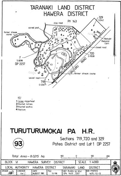
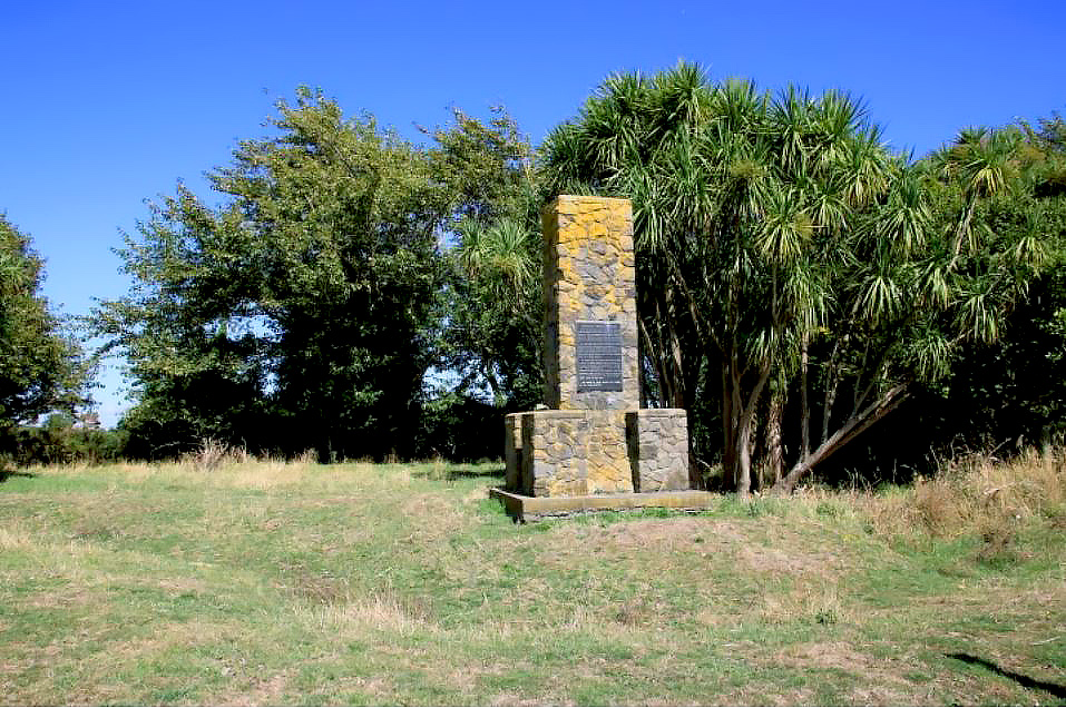
The Turuturu-mokai complex near Hawera encompasses three sites: Te Umu a Tongahake Pā (New Zealand Archaeological Association (NZAA) Site Q21/4), and Turuturu-mokai Pā (NZAA Q21/3) and Armed Constabulary Redoubt and Memorial (NZAA Q21/328). This place is widely acknowledged as a site of cultural, historical, social and archaeological significance to both Pakeha and Māori communities. The pā sites have long been recognised as outstanding examples of pre-European Māori earthworks and since the late nineteenth century have been promoted as a tourist destination for visitors to the Hawera District. The Turuturu-mokai Redoubt, constructed near the pā during the Taranaki Land Wars of 1866–1869, was famously attacked by Ngā Ruahine leader Riwha Titokowaru's forces in July 1868. The redoubt was held but at the cost to the Armed Constabulary of ten lives. A monument to those who took part in the engagement has been erected at the site. The Turuturu-mokai Redoubt, gazetted as a blockhouse site in 1871, was vested in the Borough of Hawera in 1901 so that ‘the fortifications standing thereon may be preserved’. In 1905, Turuturu-mokai Pā was also set aside as a Historic Reserve. The pa site of Te Umu-a-Tongahake was purchased and added to the reserve in July 1936. The entire complex was was returned to the guardianship of the Ngāti Tupaia hapū of Ngāti Ruanui in 2003, who allow access for the general public to visit the site. Te Umu a Tongahake Pā is situated on the opposite (northern) right bank of the Tawhiti Stream from Turuturu-mokai Pā. This is a traditional single unit, ring ditch pā site, consisting of a roughly oval platform, containing clusters of storage pits defended by a double line of encircling ditch and banks. Although traditional Māori histories pertaining to this site have not been published, the site is generally considered to be closely associated with the nearby site of Turuturu-mokai. It has been stated that the two pā were formerly linked by a tunnel which led from the trenches of Turuturu-mokai and passed beneath the Tawhiti Stream. Day has traced this story to a hearsay account from 1870 and refers to the tunnel ‘as a piece of folklore’ that was ‘repeated by later commentators’. The NZAA site record for this site cites Hawera historian John Houston as the source of the name Te Umu a Tongahake but notes that the name Pūkakariki is also named at this location in an early land plan. The site of Te Umu-a-Tongahake Pa may also have been reconstructed during the late 1930s, not long after the site was amalgamated into the Turuturu-mokai Historic Reserve. When archaeologist Alistair Buist first recorded the site on the NZAA Site Recording Scheme recording in 1964 he commented that ‘at least it [the site] hasn't been restored as has Turuturu-mokai Pa.’ More recently, Kelvin Day cited earlier correspondence that he believes infers the site was modified in 1936 as part of a scheme to reconstruct Te Umu-a-Tongahake. Day goes on to state that it would appear that the ditches and pits on Te Umu-a-Tongahake were cleaned out as they have a very similar profile to those of Turuturu-mokai. Today the site remains in reasonable condition. Regular groupings of open pits can be clearly seen laid out on the main platform of the pā and the surrounding defensive ditch and banks remain in good condition. Ngati Tupaia’s kaitiakitanga involves removing a stand of old pine trees and willows from the northwest and northern flanks of the pā, which will ultimately increase the public visibility of the site and its component features.
Location
List Entry Information
Overview
Detailed List Entry
Status
Listed
List Entry Status
Historic Place Category 2
Access
Able to Visit
List Number
6043
Date Entered
6th June 1985
Date of Effect
6th June 1985
City/District Council
South Taranaki District
Region
Taranaki Region
Extent of List Entry
Extent includes part of the land described as Pt Sec 177 PATEA Dist (RT TNB1/614), Taranaki Land District and the archaeological site known as Te Umu a Tongahake Pā (NZAA site Q21/4) thereon, as shown in the extent map tabled at the Rārangi Korēro Committee meeting on 31 May 2018.
Legal description
Pt Sec 177 PATEA Dist (RT TNB1/614), Taranaki Land District
Related listings

Stay up to date with Heritage this month
