

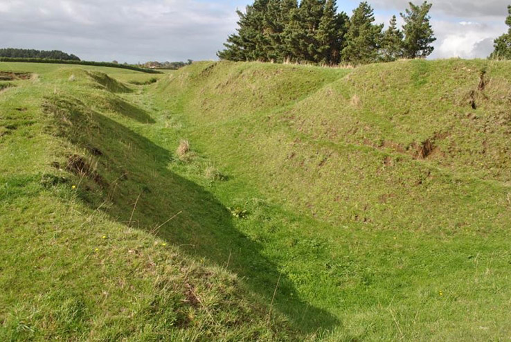
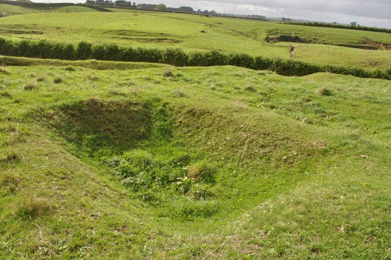
This pā (NZAA site Q21/43), near Hawera, has archaeological and cultural significance as a well preserved example of a pre-European Māori pā site for which the Taranaki region is well known. It also has historical significance for its association with the Taranaki Land Wars, as the Patea Field Force built the first Camp Waihi on it in 1866. It is adjacent to the second Camp Waihi (including redoubt, built 1867; NZAA Q21/151), and the Waihi Cemetery (NZAA Q21/316), which contains the graves of members of the New Zealand Armed Constabulary killed during these wars between 1866 and 1868, and some early settlers of the Hawera district. The pā is named Pikituroa on a land plan from 1900. No historic accounts or references to the Māori occupation of the pā appear to have been published, and its original Māori name is uncertain. An unverified twentieth century newspaper report describes the site as: ‘the old Māori redoubt adjoining the cemetery. This old redoubt has a history, and was used in the tribal wars of long ago. The trenches and pits were dug with spades of wood by a tribe of natives named Araukauku, whose chief's name was Mangamanga. Both Te Whenuku and Pikituroa are named in the general vicinity of the pā site on the 1900 land plan, which incidentally places Mangamanga at another location (also recorded as a military redoubt) 1 kilometre northwest of the pā. The only contemporary reference that equates Mangamanga with the site of Waihi is derived from Magistrate James Booth's English translation of Ngā Ruahine/Ngāti Ruanui leader Riwha Tītokowaru's famous goading of Lieutenant Colonel Thomas McDonnell, in a letter prior to the latter's defeat at Te Ngutu O Te Manu in 1868. Booth’s authority for identifying Mangamanga as Camp Waihi is not explained. Most published twentieth century historical accounts since have accepted Booth's translation and referred to Mangamanga as the Waihi Camp. Archaeologist Alistair Buist made particular mention of the excellent state of the pā when first visited in 1961, noting that: ‘It is extremely well preserved and on this account does not give the appearance of being as old as the majority of sites in the area. The scarps are for the most part quite perpendicular, a state which is unusual in local sites, most of which have scarps which are easily climbed.’ The site consists of a single, roughly rectangular, platform defended by an encircling ditch and bank on four sides. An additional lateral ditch and bank has been excavated on the north-west flank of the site that has an unfinished appearance and may relate to the later occupation by the Armed Constabulary. At least 24 pits are located on the platform of the site. In many cases these pits are arranged in groups separated by baulks; this is a feature of Māori storage pit layout found elsewhere on pā sites in South Taranaki. Armed Constabulary Occupation: The first Camp Waihi was constructed at this pā by the Patea Field Force under Lieutenant-Colonel McDonnell during September 1866. At this time the site was referred to in most official reports and newspaper accounts as Te Whenuku. Confirmation that the Waihi Camp was initially situated on a former Māori pā site comes from the reminiscences of Captain Newland, who describes the building of the redoubt at such a pā in 1866: ‘Mangamanga was the name of the old pā, but it was always called Waihi, as the old name was not then known. It did not take long to build the redoubt as the old trenches required cleaning out only on three sides.’ The attribution of the name Mangamanga to the pā site in Newland's account has been influenced by another source sometime after the events described. The pā remains in generally excellent condition, under grass and grazed by light stock. Perhaps the best indication of nineteenth century reuse of the site by the Armed Constabulary is the near vertical scarps of the defensive ditch and the open storage pits on the platform, which remain clearly visible and still look as if they were only recently abandoned.
Location
List Entry Information
Overview
Detailed List Entry
Status
Listed
List Entry Status
Historic Place Category 2
Access
Private/No Public Access
List Number
6044
Date Entered
6th June 1985
Date of Effect
6th June 1985
City/District Council
South Taranaki District
Region
Taranaki Region
Extent of List Entry
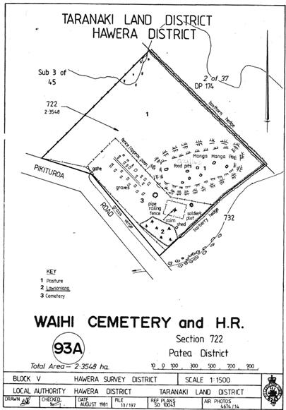
Extent includes part of the land described as SEC 722 Patea District (NZ Gazette 1984 p 3622), Taranaki Land District, and the archaeological site known as Pā (NZAA site Q21/43) thereon, as shown in the extent map tabled at the Rārangi Korēro Committee meeting on 31 May 2018.
Legal description
SEC 722 Patea District (NZ Gazette 1984 p 3622), Taranaki Land District
Stay up to date with Heritage this month
