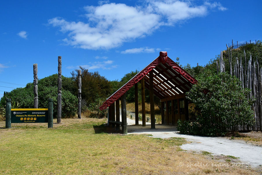
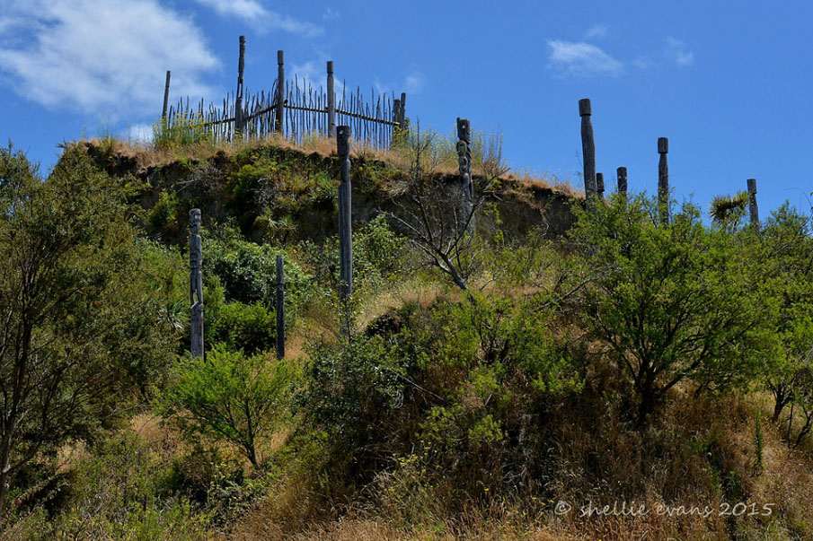
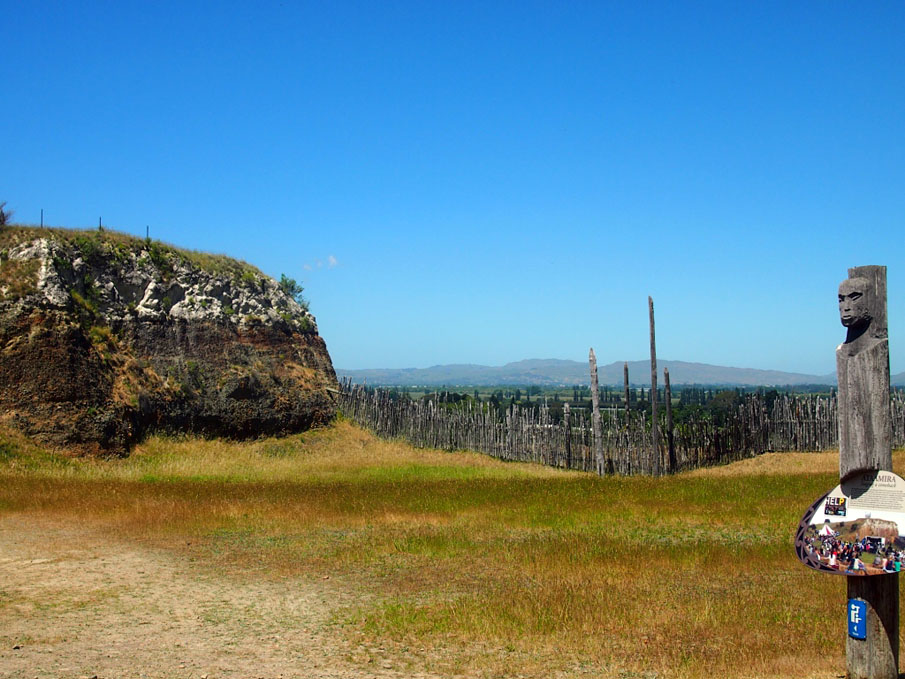
Ōtātara Pā has considerable archaeological significance as it is one of the earliest and most remarkable extant pā complexes in New Zealand. Ōtātara Pā stands apart from other pā complexes such as One Tree Hill and Te Koru because of its sheer size (44 hectares) and the complexity of its archaeological features, which have largely remained intact since the site's abandonment. The elaborate design of Ōtātara Pā with its numerous small terraces and immense storage pits is a testament to the skill of the original builders. Ōtātara Pā is also a rare example of early pā construction as the large scale earthwork defences commonly found on pā sites throughout the North Island and upper South Island are notably absent, a fact that has long puzzled archaeologists given the physical extent of the site and the considerable population that would have lived there (as implied by the abundance of pits and terraces).
Ōtātara Pā is a place of tremendous cultural, traditional and spiritual significance to Ngāti Kahungunu iwi, particularly Ngāti Paarau Hapu of Waiohiki who are kaitiaki for the site The people of Waiohiki 'live in the shadow' of Ōtātara Pā and regard it as the original marae of Heretaunga. Ōtātara Pā commemorates the arrival of Taraia and his people (Ngāti Kahungunu) in Heretaunga. Maori oral tradition indicates that Ōtātara Pā was captured by Taraia of Ngāti Kahungunu in the sixteenth century, forcing its inhabitants to flee the area. It was from Ōtātara Pā that Ngāti Kahungunu 'gained a foothold in Heretaunga' and established themselves as the dominant iwi in the Hawkes Bay and Wairarapā through a variety of means including conquest and intermarriage. Ngāti Paarau feel that they have traditional responsibility for looking after Ōtātara Pā and have been closely involved with the management of the Ōtātara Pā Historic Reserve since the late 1980's. Ngāti Paarau's immense pride for Ōtātara Pā is reflected by their desire to see the archaeological complex classified as an ICOMOS World Heritage Site.


List Entry Information
Status
Listed
List Entry Status
Historic Place Category 1
Access
Able to Visit
List Number
6418
Date Entered
22nd January 1985
Date of Effect
22nd January 1985
City/District Council
Napier City
Region
Hawke's Bay Region
Extent of List Entry
Extent includes the land described as Lot 2 DP 404875 (RT 420701) and Ōtātara Pā Historic Reserve: Lot 1 DP 6448, Sec 11 Blk VII Heretaunga SD, Blk 176 Puketapu CGD, Lots 10-11 DP 12805, Lot 1 DP 12898, Lot 4 DP 311299, Lot 2 DP 341324, Lot 1 DP 6687 and Lot 1 DP 404875 (NZ Gazette 1979 p.316, 1979 p.1714, 1979 p.2035, 2005 p.2599, 2008 p.3853, 2022 In-1019; RTs HBE1/1223, HBE1/1224, 44611, 169889, HB102/158, 420700), Hawkes Bay Land District, and the structures and archaeological features known as Ōtātara Pā thereon.
Legal description
Lot 2 DP 404875 (RT 420701) and Ōtātara Pā Historic Reserve: Lot 1 DP 6448, Sec 11 Blk VII Heretaunga SD, Blk 176 Puketapu CGD, Lots 10-11 DP 12805, Lot 1 DP 12898, Lot 4 DP 311299, Lot 2 DP 341324, Lot 1 DP 6687 and Lot 1 DP 404875 (NZ Gazette 1979 p.316, 1979 p.1714, 1979 p.2035, 2005 p.2599, 2008 p.3853, 2022 In-1019; RTs HBE1/1223, HBE1/1224, 44611, 169889, HB102/158, 420700), Hawkes Bay Land District
Location Description
Otatara pa Historic Reserve is situated on Redcliffe hills on left bank of Tutaekuri river with access off Springfield Road, and adjacent to Eastern Institute of Technology at Taradale, Napier, Hawke's Bay
Status
Listed
List Entry Status
Historic Place Category 1
Access
Able to Visit
List Number
6418
Date Entered
22nd January 1985
Date of Effect
22nd January 1985
City/District Council
Napier City
Region
Hawke's Bay Region
Extent of List Entry
Extent includes the land described as Lot 2 DP 404875 (RT 420701) and Ōtātara Pā Historic Reserve: Lot 1 DP 6448, Sec 11 Blk VII Heretaunga SD, Blk 176 Puketapu CGD, Lots 10-11 DP 12805, Lot 1 DP 12898, Lot 4 DP 311299, Lot 2 DP 341324, Lot 1 DP 6687 and Lot 1 DP 404875 (NZ Gazette 1979 p.316, 1979 p.1714, 1979 p.2035, 2005 p.2599, 2008 p.3853, 2022 In-1019; RTs HBE1/1223, HBE1/1224, 44611, 169889, HB102/158, 420700), Hawkes Bay Land District, and the structures and archaeological features known as Ōtātara Pā thereon.
Legal description
Lot 2 DP 404875 (RT 420701) and Ōtātara Pā Historic Reserve: Lot 1 DP 6448, Sec 11 Blk VII Heretaunga SD, Blk 176 Puketapu CGD, Lots 10-11 DP 12805, Lot 1 DP 12898, Lot 4 DP 311299, Lot 2 DP 341324, Lot 1 DP 6687 and Lot 1 DP 404875 (NZ Gazette 1979 p.316, 1979 p.1714, 1979 p.2035, 2005 p.2599, 2008 p.3853, 2022 In-1019; RTs HBE1/1223, HBE1/1224, 44611, 169889, HB102/158, 420700), Hawkes Bay Land District
Location Description
Otatara pa Historic Reserve is situated on Redcliffe hills on left bank of Tutaekuri river with access off Springfield Road, and adjacent to Eastern Institute of Technology at Taradale, Napier, Hawke's Bay
Why is this place significant?
Cultural Significance
Otatara Pa is regarded by the people of Waiohiki as the original marae of Heretaunga. It has tremendous cultural, traditional, spiritual and social significance to Ngati Kahungunu, and is regarded as a wahi tapu by Ngati Paarau of Waiohiki Marae who "live in the shadow" of Otatara Pa. Ngati Paarau feel that they have traditional responsibility for looking after Otatara Pa and have been closely involved with the management of the Otatara Pa Historic Reserve since the late 1980s.
Historic Significance
Historical Significance or Value Otatara Pa is historically significant as the place that commemorates the arrival of Taraia and his people (Ngati Kahungunu) in Heretaunga. It was from Otatara that Ngati Kahungunu "gained a foothold in Heretaunga" and established themselves as the dominant iwi in the Hawkes Bay and Wairarapa through a variety of means including conquest and intermarriage.
Physical Significance
Otatara Pa has considerable archaeological significance as it is one of the earliest and most remarkable extant pa complexes in New Zealand. Otatara Pa stands apart from other pa complexes such as One Tree Hill and Te Koru because of its sheer size (44 hectares) and the complexity of its archaeological features, which have largely remained intact since the site's abandonment. The elaborate design of Otatara Pa with its numerous small terraces and immense storage pits is a testament to the skill of the original builders. Otatara is a rare example of early pa construction as the large scale earthwork defences commonly found on pa sites throughout the North Island and upper South Island are notably absent, a fact that has long puzzled archaeologists given the physical extent of the site and the considerable population that would have lived there (as implied by the abundance of pits and terraces). In the words of archaeologist Les Groube, "Otatara Pa is a symbol of the vitality and resourcefulness of the earliest agricultural settlers of Hawke's Bay, the ancestors of Ngati Kahungunu. It must not be allowed to disappear beneath the blades of bulldozers". Otatara has tremendous aesthetic value, despite what is referred to as "encroaching urbanisation". Otatara Pa is a visually impressive site, both from the air and on the ground and it provides spectacular panoramic views of the surrounding environment, from the sea to the Heretaunga Plains and inland to the Kaweka Ranges. These views would clearly have been of importance to the original inhabitants of Otatara Pa and there is no doubt that this site was chosen for its "strategic position as an outstanding vantage point".
Why is this place Category 1 / Category 2?
Detail Of Assessed Criteria
(a) The extent to which the place reflects important or representative aspects of New Zealand history. Otatara Pa is an excellent representative example of sites built during the early period of pa construction in New Zealand prehistory. (b) The association of the place with events, persons, or ideas of importance in New Zealand history. Otatara Pa has a strong association with Taraia of Ngati Kahungunu who is believed to have been responsible for the capture/abandonment of Otatara Pa in the 16th century. Taraia's actions caused the inhabitants to flee, thereby leaving Heretaunga "firmly in the hands of the Kahungunu". (c) The potential of the place to provide knowledge of New Zealand history. There is a high potential for Otatara Pa to contribute to our knowledge of the prehistoric occupation of Heretaunga. There has been little systematic archaeological investigation at Otatara Pa but any future archaeological inquiry should be limited to initiatives such as the Department of Conservation's recent commissioning of a detailed three-dimension map of the entire archaeological complex as invasive excavation techniques cause irreversible damage to archaeological features. (d) The importance of the place to the tangata whenua. Otatara Pa is of great importance to Ngati Kahungunu, in particular Ngati Paarau hapu of Waiohiki Marae. Waiohiki Marae "sits in the shadow of Otatara" and this close physical association has been a key factor in Ngati Paarau's active involvement with the site over the past eighteen years. Otatara Pa also links to the whakapapa of several other iwi including Ngai Tahu and Ngati Awa. (f) The potential of the place for public education. Otatara Pa has tremendous potential in terms of public education, and new interpretation is currently being developed for the site by the Department of Conservation in consultation with the Waiohiki Marae Committee. A resource kit for teachers was prepared by Elizabeth Pishief in 2002 titled: 'Super Sites for Conservation Education - Otatara Pa Historic Reserve'. (g) The technical accomplishment or value, or design of the place. The archaeological complex of Otatara Pa is an elaborate system of earthwork features including storage pits and numerous small terraces for housing. These features "are a tribute to the craft and skill of the original builders who modified the site with expertise and an apparent sympathy for the environment". (i) The importance of identifying historic places known to date from early periods of New Zealand settlement. The currently accepted date for the initial Polynesian settlement of Aotearoa is 1100-1200 AD and 1500 AD is widely regarded as the approximate date at which pa construction began. Radiocarbon samples indicate that Otatara Pa was occupied by 1500 AD, thereby suggesting that it is an early example of pa construction. (j) The importance of identifying rare types of historic places. Whilst there are number of extant pa throughout the North Island and upper South Island, Otatara Pa is unique because of its sheer size (44 hectares) and the complexity of its earthworks. (k) The extent to which the place forms part of a wider historical and cultural complex or historical and cultural landscape. Otatara Pa is an integral part of a wider historical cultural landscape that reflects the prehistoric settlement and occupation of Heretaunga. This historical and cultural landscape includes several other pa such as Puketapu Pa (to the northwest of Otatara Pa on the northern bank of the Tutaekuri River) and numerous pit, terrace and midden sites.
Why is this place significant?
Cultural Significance
Otatara Pa is regarded by the people of Waiohiki as the original marae of Heretaunga. It has tremendous cultural, traditional, spiritual and social significance to Ngati Kahungunu, and is regarded as a wahi tapu by Ngati Paarau of Waiohiki Marae who "live in the shadow" of Otatara Pa. Ngati Paarau feel that they have traditional responsibility for looking after Otatara Pa and have been closely involved with the management of the Otatara Pa Historic Reserve since the late 1980s.
Historic Significance
Historical Significance or Value Otatara Pa is historically significant as the place that commemorates the arrival of Taraia and his people (Ngati Kahungunu) in Heretaunga. It was from Otatara that Ngati Kahungunu "gained a foothold in Heretaunga" and established themselves as the dominant iwi in the Hawkes Bay and Wairarapa through a variety of means including conquest and intermarriage.
Physical Significance
Otatara Pa has considerable archaeological significance as it is one of the earliest and most remarkable extant pa complexes in New Zealand. Otatara Pa stands apart from other pa complexes such as One Tree Hill and Te Koru because of its sheer size (44 hectares) and the complexity of its archaeological features, which have largely remained intact since the site's abandonment. The elaborate design of Otatara Pa with its numerous small terraces and immense storage pits is a testament to the skill of the original builders. Otatara is a rare example of early pa construction as the large scale earthwork defences commonly found on pa sites throughout the North Island and upper South Island are notably absent, a fact that has long puzzled archaeologists given the physical extent of the site and the considerable population that would have lived there (as implied by the abundance of pits and terraces). In the words of archaeologist Les Groube, "Otatara Pa is a symbol of the vitality and resourcefulness of the earliest agricultural settlers of Hawke's Bay, the ancestors of Ngati Kahungunu. It must not be allowed to disappear beneath the blades of bulldozers". Otatara has tremendous aesthetic value, despite what is referred to as "encroaching urbanisation". Otatara Pa is a visually impressive site, both from the air and on the ground and it provides spectacular panoramic views of the surrounding environment, from the sea to the Heretaunga Plains and inland to the Kaweka Ranges. These views would clearly have been of importance to the original inhabitants of Otatara Pa and there is no doubt that this site was chosen for its "strategic position as an outstanding vantage point".
Why is this place Category 1 / Category 2?
Detail Of Assessed Criteria
(a) The extent to which the place reflects important or representative aspects of New Zealand history. Otatara Pa is an excellent representative example of sites built during the early period of pa construction in New Zealand prehistory. (b) The association of the place with events, persons, or ideas of importance in New Zealand history. Otatara Pa has a strong association with Taraia of Ngati Kahungunu who is believed to have been responsible for the capture/abandonment of Otatara Pa in the 16th century. Taraia's actions caused the inhabitants to flee, thereby leaving Heretaunga "firmly in the hands of the Kahungunu". (c) The potential of the place to provide knowledge of New Zealand history. There is a high potential for Otatara Pa to contribute to our knowledge of the prehistoric occupation of Heretaunga. There has been little systematic archaeological investigation at Otatara Pa but any future archaeological inquiry should be limited to initiatives such as the Department of Conservation's recent commissioning of a detailed three-dimension map of the entire archaeological complex as invasive excavation techniques cause irreversible damage to archaeological features. (d) The importance of the place to the tangata whenua. Otatara Pa is of great importance to Ngati Kahungunu, in particular Ngati Paarau hapu of Waiohiki Marae. Waiohiki Marae "sits in the shadow of Otatara" and this close physical association has been a key factor in Ngati Paarau's active involvement with the site over the past eighteen years. Otatara Pa also links to the whakapapa of several other iwi including Ngai Tahu and Ngati Awa. (f) The potential of the place for public education. Otatara Pa has tremendous potential in terms of public education, and new interpretation is currently being developed for the site by the Department of Conservation in consultation with the Waiohiki Marae Committee. A resource kit for teachers was prepared by Elizabeth Pishief in 2002 titled: 'Super Sites for Conservation Education - Otatara Pa Historic Reserve'. (g) The technical accomplishment or value, or design of the place. The archaeological complex of Otatara Pa is an elaborate system of earthwork features including storage pits and numerous small terraces for housing. These features "are a tribute to the craft and skill of the original builders who modified the site with expertise and an apparent sympathy for the environment". (i) The importance of identifying historic places known to date from early periods of New Zealand settlement. The currently accepted date for the initial Polynesian settlement of Aotearoa is 1100-1200 AD and 1500 AD is widely regarded as the approximate date at which pa construction began. Radiocarbon samples indicate that Otatara Pa was occupied by 1500 AD, thereby suggesting that it is an early example of pa construction. (j) The importance of identifying rare types of historic places. Whilst there are number of extant pa throughout the North Island and upper South Island, Otatara Pa is unique because of its sheer size (44 hectares) and the complexity of its earthworks. (k) The extent to which the place forms part of a wider historical and cultural complex or historical and cultural landscape. Otatara Pa is an integral part of a wider historical cultural landscape that reflects the prehistoric settlement and occupation of Heretaunga. This historical and cultural landscape includes several other pa such as Puketapu Pa (to the northwest of Otatara Pa on the northern bank of the Tutaekuri River) and numerous pit, terrace and midden sites.
Construction Details
Start Year
1500
Finish Year
1600
Type
Original Construction
Construction Materials
Archaeological site - terraces, pits remaining evidence of original construction
Notable Features
Notable features of the Otatara complex are two pa sites; Hikurangi and Otatara (now largely destroyed by quarrying), numerous terraces, pits and middens and ditch and bank features.
Construction Details
Start Year
1500
Finish Year
1600
Type
Original Construction
Construction Materials
Archaeological site - terraces, pits remaining evidence of original construction
Notable Features
Notable features of the Otatara complex are two pa sites; Hikurangi and Otatara (now largely destroyed by quarrying), numerous terraces, pits and middens and ditch and bank features.
The history of Otatara Pa Historic Reserve is taken from "Assessment of Significance: Otatara Pa Historic Reserve " which has divided the history into two distinct parts: the traditional Maori history and the history of the land since it came into European ownership in 1851. The traditional history has been further divided into sections with each section being composed of several versions of each story. The stories are grouped under: The Original Inhabitants of Heretaunga and the Builders of Otatara; Two Stories about Otatara Prior to the Arrival of Ngati Kahungunu; The Arrival of Ngati Kahungunu in Heretaunga; and The Consolidation of Ngati Kahungunu's Mana in Heretaunga. The history indicates how complex and interesting Maori traditional history is and that although it is impossible to determine the actual course of events at Otatara Pa, the significance of those events is not destroyed by the difficulty. The crucial event is that taraia arrived in Heretaunga and Otatara is the place that commemorates that arrival. The stories relate how everyone is linked to Otatara - through occupation, conquest, marriage and mana - and the whakapapa binds them all together. The history of the site is divided into three sections: the Tangata Whenua; the Europeans and the Archaeological history.
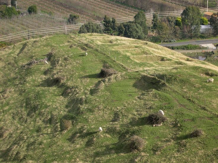
Otatara is a large archaeological complex of pa, terraces, house sites and pits covering 44 hectares. Otatara Pa proper (V21/168) is located on the north-facing slope of the old Redcliffe quarry in the southeast corner of the reserve. Although quarrying activities largely destroyed this pa, Jones provides a full description of the site in Pishief (1997:56-58) using 1949 aerial photographs. Notable features included a transverse ditch and bank on the rise to the central tihi on the western end of the site, scarps and terraces and ridge top pits. Hikurangi Pa (V21/41) is the upper pa site within the Reserve and is described by Walter and Gosling (2002:7) as "an extensive site consisting of three ridge platforms. These platforms are spaced along a central ridgeline, with terraced ridges and faces to the west, south and southeast". Other significant archaeological features within the revised boundary of the Historic Reserve include pit and terrace sites V21/218, V21/282, V21/283, V21/284, and V21/285. V21/218 is a multiple pit site that straddles the ridgeline between Lots 6 and 7 and partly extends into Lot 9 of the former Springwinds subdivision, which also contains site V21/283, a series of well-formed terraces. V21/282 is a single pit site situated within Lot 8 of the former Springwinds subdivision and V21/284 is a terrace site located mostly in Lot 5 of the former Springwinds subdivision. Lot 4 of the former Springwinds subdivision contains terrace site V21/285. The archaeological complex of Otatara also extends westward into Lots 2, 3 and 10 of the former Springwinds subdivision, with three significant sites (V21/217, V21/289 and V21/290) being located in Lot 10. V21/217 is a group of approximately seventeen pits at the southern end of Lot 10 and V21/289 and V21/290 are pit and terrace sites located on the northeastern side of Lot 10 and extending into the Otatara Pa Historic Reserve.
Historical and Associated Iwi / Hapū / Whānau
Iwi: Ngāti Kahungunu
Hapu: Ngāti Paarau
Iwi: Ngāti Kahungunu ki Heretaunga
Public NZAA Number
V21/168
Completion Date
24th June 2005
Report Written By
Jo Wylie
Information Sources
Department of Conservation
Land Information New Zealand (LINZ)
Land Information New Zealand
MacLean, 2002 (2)
R. McLean, 'Otatara Pa Heritage Order Investigation'. Wellington: New Zealand Historic Places Trust, 2002.
New Zealand Archaeological Association (NZAA)
New Zealand Archaeological Association
Pischief, 1997
E. Pishief,' Assessment of Heritage Significance: Otatara Pa Historic Reserve. Napier', Department of Conservation East Coast Hawke's Bay Conservancy, 1997
Conservation Plan
Conservation Plan
Other Information
Hapu - Ngāti Paarau Historic Reserve - NZ Gazette 1973:1833, 1979:316, 1979:1714, 1979:2035, 2005: 2599 A fully referenced version of this report is available from the NZHPT Central Region Please note that entry on the New Zealand Heritage List/Rarangi Korero identifies only the heritage values of the property concerned, and should not be construed as advice on the state of the property, or as a comment of its soundness or safety, including in regard to earthquake risk, safety in the event of fire, or insanitary conditions.
Historical and Associated Iwi / Hapū / Whānau
Iwi: Ngāti Kahungunu
Hapu: Ngāti Paarau
Iwi: Ngāti Kahungunu ki Heretaunga
Public NZAA Number
V21/168
Completion Date
24th June 2005
Report Written By
Jo Wylie
Information Sources
Department of Conservation
Land Information New Zealand (LINZ)
Land Information New Zealand
MacLean, 2002 (2)
R. McLean, 'Otatara Pa Heritage Order Investigation'. Wellington: New Zealand Historic Places Trust, 2002.
New Zealand Archaeological Association (NZAA)
New Zealand Archaeological Association
Pischief, 1997
E. Pishief,' Assessment of Heritage Significance: Otatara Pa Historic Reserve. Napier', Department of Conservation East Coast Hawke's Bay Conservancy, 1997
Conservation Plan
Conservation Plan
Other Information
Hapu - Ngāti Paarau Historic Reserve - NZ Gazette 1973:1833, 1979:316, 1979:1714, 1979:2035, 2005: 2599 A fully referenced version of this report is available from the NZHPT Central Region Please note that entry on the New Zealand Heritage List/Rarangi Korero identifies only the heritage values of the property concerned, and should not be construed as advice on the state of the property, or as a comment of its soundness or safety, including in regard to earthquake risk, safety in the event of fire, or insanitary conditions.
Current Usages
Uses: Civic Facilities
Specific Usage: Historic or recreation reserve
Former Usages
General Usage: Cultural Landscape
Specific Usage: Ancestral landscape
General Usage: Maori
Specific Usage: kau-whanga-a-riri (landscape feature of battle site)
General Usage: Maori
Specific Usage: Midden
General Usage: Maori
Specific Usage: Pā
General Usage: Maori
Specific Usage: Place associated with particular ancestors
Themes
Traditional Site (HPA 1980)
Archaeological Site (HPA 1980)
Of Significance to Maori
Current Usages
Uses: Civic Facilities
Specific Usage: Historic or recreation reserve
Former Usages
General Usage: Cultural Landscape
Specific Usage: Ancestral landscape
General Usage: Maori
Specific Usage: kau-whanga-a-riri (landscape feature of battle site)
General Usage: Maori
Specific Usage: Midden
General Usage: Maori
Specific Usage: Pā
General Usage: Maori
Specific Usage: Place associated with particular ancestors
Themes
Traditional Site (HPA 1980)
Archaeological Site (HPA 1980)
Of Significance to Maori
Location
Sign up to hear more
Get the latest heritage news, features and events delivered
straight to your inbox.