

The early history of Paepaehakumanu Motutara is reflected partly in the archaeological landscape and more richly in written and oral traditions that outline the ongoing significance of the area to Ngati Whakaue. It is a Wahi Tapu (sacred/spiritual) place where according to Maori mythology the geothermal features were created by tohunga, Ngatoroirangi. It is also a place where battles were fought, and koiwi deposited after battles. It has traditional values as an area with rich sources of food and fibre and with rocky outcrops well suited to sharpening weapons and tools. It was also valued for the medicinal properties of the sulphurous thermal pools and rongoa or medicinal plants growing there. The earliest European visitors took benefit from the healing properties of the hot springs heedless of the lack of facilities, but the Government of the day had a grand vision for the area. As early as the late 1870s it was viewed and developed by the Crown and its colonising agents as an antipodean version of a great European spa town.
In 1881, an agreement reached between Ngati Whakaue leaders, the judiciary, and Government agents, was legalised by the Thermal Springs District Act 1881. The town of Rotorua and, within that, an area of 50 acres containing many medicinal thermal springs was created, ‘Hei oranga mo nga iwi katoa o te Ao’ (for the benefit of the people of the world), this latter being the forerunner of the Rotorua Government Gardens. A town built on the perceptiveness, dreams, philanthropy and goodwill of the native owners was to have a long period of infancy for the Ngati Whakaue and Te Arawa people.
The origins of the township of Rotorua began with Crown negotiations between Ngati Whakaue chiefs over the block of land known as Te Pukeroa Oruawhata in the latter half of the 1870s. From 1873 to 1877 the operation of the Native Land Court was suspended by Government because a number of iwi/hapu from the Lakes District were in open opposition to some of its rulings. An agreement known as the Fenton Agreement was reached in November 1880, and was recognised as a document to give rise to the establishment of the township of Rotorua. The Fenton Agreement was followed in 1883 by one known as the Clarke Agreement signed by Government representative Henry Tacy Clarke and Ngati Whakaue, on 26 February of that year. That Agreement led to divisions of titles within the township block and the beliefs of the local owners that they would receive handsome returns for the lease of their land by the Crown and its agencies.
The resulting 1886 eruption of Mount Tarawera with its ensuing disastrous affect on the iwi/hapu of Te Arawa and defaulting and non payments from lessees who had contracted their government agents to be involved in the growth of Rotorua Township, led to the outright sale of some of the shares in Te Pukeroa Oruawhata by some of its owners. In 1889 Ngati Whakaue elders negotiated a prerequisite that a total of 20 acres encompassing some 48 township lots, were to be reserved and these lands finally became the core for what is known today as Te Pukeroa Oruawhata Trust.
Investigations over the years have been instigated by Ngati Whakaue via official petitions to Government, in 1930, 1948 and 1953. The lands had become vested in the Waiariki Maori Land Board in 1924, and in 1952 that Board transferred the administration of the blocks to the Maori Trustee.
It was not until 15 December 1980 that the Maori Land Court transferred ownership of the block to the descendants of the underlying owners, represented by 10 formally nominated Trustees (Te Pukeroa Oruawhata Trust).
When the Fenton Agreement was signed in 1881, Ngati Whakaue gifted to the Crown, certain lands to be used as public reserves in the new township; an important principle that Ngati Whakaue still stands by. The Sanatorium Reserve was one of those Reserves, still recognised today as such, by Pukeroa Oruawhata Trust and the Crown.
Contouring ground works began in 1882, including areas for cultivation of fruit trees, vegetable gardens and a fowl enclosure. The first bathhouse in New Zealand, the Priest’s Pavilion, was built in 1882 with construction of the Government Sanatorium commencing the following year. Enthusiasm verged on the euphoric, with the waters touted to cure everything from ‘congestions of the viscera’ to ‘sexual impotence’. The Reserve gradually became more sophisticated, accelerated in 1886 by the arrival of Camille Malfroy, a French geothermal engineer, who had a major impact on the development of the Reserve, including innovative thermal manipulation to create the Malfroy geysers. Rotorua’s unique situation as an essentially government owned town for 103 years meant that both the town and its Rotorua Government Gardens had enviable access to influence and Government coffers to continue to grow and develop the area’s tourist potential. Prime Minister Sir Joseph Ward was an unshakable supporter of the spa town concept. It is doubtful the main trunk rail line would have been extended from Hamilton through to Rotorua, but for such support, nor the very early investment to bring electricity to the town in 1901. With the appointment of the first Balneologist, Dr Arthur Wohlmann, in 1902, more sophisticated treatments were installed and the buildings, grounds and plantings carefully designed and developed to transform the Sanatorium into a modern scientific health spa. An approach keenly supported by Thomas Donne head of the Department of Tourist and Health Resorts.
Over the next twenty five years the grounds were further developed on an impressive scale with plantings, walks, lakelets and rockeries to complement the new buildings, appearing across the site. The Sanatorium was rebuilt after a fire, the original Blue Baths appeared and a camera obscura was built atop the ticket office. Other attractions that were complimentary to ‘taking the waters’ and designed to offer a wider recreation experience, began to appear around 1900, including: a band rotunda; tearoom; small zoo and aviary; formal areas developed for playing tennis, croquet and bowls; the Prince’s Gate Arch and the Duchess Bath both the latter two in honour of a royal visit. Entertainment was also important and music played daily, provided by brass bands (one Maori and one European) and an orchestra. It was Wohlmann’s concept that strongly influenced the design of the Rotorua Government Gardens’ most prominent building, the Rotorua Bath House (Former) now the Rotorua Museum of Art and History, built in the Elizabethan revival style and opened in 1908. Later structures added to the Gardens include the 1934 replacement Blue Baths, its design unique in New Zealand, and various statutory including several war memorials.
The Rotorua Government Gardens’ outstanding aesthetic value is centred around stark cultural, contemporary and historical contrasts. There are both natural and archaeological elements within the area that are evidence of its early and wide ranging use by tangata whenua. Also, the wairua that iwi and hapu associate with this place still exists and reverberates through things such as whakairo that still stand in different forms around the gardens and through the natural, geothermal features themselves. Features such as the surviving rocky outcrops used to sharpen tools and weapons and areas where valued plants grow and continue to be used for their medicinal values as well as for their fibre and fibre dyeing qualities. It is a place where battle skirmishes took place in open, scrubby, geothermal areas that are now pristine, manicured bowling and croquet greens. Further contrast is in a combination of its six spa related registered historic places, each with its own experiential and aesthetic qualities, along with other commemorative and cultural structures and their interrelationship and setting within the ornamental public grounds and thermal landscape. Internationally renowned, it has been one of New Zealand and Rotorua’s primary tourist attractions since the 1880s. The surviving historic places are unequivocal evidence of the social value placed on the Gardens by the community, who time and again have fought for their retention. It is of special significance that Ngati Whakaue are keen to ensure that this land they gifted continues to comply with the original deed of gift, of being used for health and recreation by the ‘people of the world’. It was thanks to the perceptive goodwill of Te Arawa kaumatua that the town of Rotorua was established. The place has importance as the most extensively developed therapeutic spa in New Zealand. The area has strong architectural values, retaining as it does, a range of places from late nineteenth to early twentieth century style, all of which served or supported the health spa function and associated recreational purposes. Alongside this, its landscape architecture is highly significant. The area has been continuously gardened since 1881, they demonstrate the principal characteristics of a distinctive landscape type and way of life no longer practiced; the Edwardian ideal of a spa landscape and pleasure garden. The Gardens were also treated like a botanic garden; a place to educate visitors about plants, particularly native species. Scientifically, it is a site that provides an important example of international medical and balneological theory and was the location for many Government led experimental plantings and has an important place in the history of garden and botanical development in New Zealand. Technologically, examples of early innovations survive in its buildings, including the unique use of local pumice concrete and raft type foundations. The skill of French geological engineer Camille Malfroy oversaw significant and unique inventions to improve amenities and solved problems with building equipment wiring and drainage. His design of the Malfroy Geysers, by technically manipulating the thermal activity, was considered outstanding. It has archaeological significance relating to the potential subsurface historic remains of pre 1900 buildings, the original garden layout and changes over time and two sites recorded by the New Zealand Archaeological Association; a midden and a hoanga. The area has strong spiritual significance as a wahi tapu and sacred place for Ngati Whakaue where in Maori mythology, tohunga, Ngatoroirangi created the geothermal features as well as a place where important chiefs were buried and battles were fought. It has traditional values as a source of food, especially fresh water species and birds; for gathering of plants for their fibre dyeing and medicinal properties, and the medicinal values of the thermal pools, and mud.
List Entry Information
Status
Listed
List Entry Status
Historic Area
Access
Able to Visit
List Number
7015
Date Entered
15th December 2011
Date of Effect
15th December 2011
City/District Council
Rotorua District
Region
Bay of Plenty Region
Extent of List Entry
Extent includes: Part of the land described as Pt Sec 2 Blk I Tarawera SD (RT SA39B/971) Recreation Reserve (NZ Gazette 1984 p. 2272); and Lot 5 DPS 45835 (RT SA39B/972) Recreation Reserve (NZ Gazette 1984 p. 2272); and Lot 2 and Pt Lot 3 and Sec 90 Blk I Tarawera SD DPS 15998 (RT SA34C/324) Recreation Reserve (NZ Gazette 1984 p. 2272); and Lots 1, 2, 3 Blk 1 Sec 2 Tarawera SD (no RT) Recreation Reserve (NZ Gazette 1986, p. 2485); and Lot 5 Blk I Sec 2 Tarawera SD (no RT); and Sec 76 Blk I Tarawera SD (no RT) Recreation Reserve (NZ Gazette 1980 p. 94); and Lot 1 DPS 15998 (RT SA14D/112) Recreation Reserve (NZ Gazette 1984 p. 2272); and Lot 1 DPS 38951 (RT SA34C/325) Recreation Reserve (NZ Gazette 1984, p. 2272); Recreation Reserve (NZ Gazette 1999 p. 1898); and Legal Road All South Auckland Land District. Off shore islets named Harua, Motutara, Moturere and Timanga have been included in this registration, these have no legal description, but are within a gazetted refuge, Lake Rotorua (Motutara) Wildlife Refuge Order 1967 p. 458. (Refer to the maps in Appendix 1 of the registration report for further information). The extent also includes the structures and their fittings and fixtures within this boundary, including the following historic places: Prince's Gate Archway, Gardener's Cottage, Band Rotunda Croquet Pavilion, Arawa Memorial, Bath House (Former) or Rotorua Museum Te Whare Taonga o Te Arawa, the original remnant of the Ward Baths within the Polynesian Spa complex, and the associated Pumphouse, Blue Baths, Malfroy Geysers, War Memorial, Wylie Memorial, Te Runanga, Band Rotunda, RAVE centre including Wohlmann House, Lewis House and 1240 Hinemaru Street. The registration also encompasses the garden landscape fabric, including the following: Queens Drive plantings, early twentieth century examples; Eucalyptus and Manuka copse; light standard; cast iron fence remnant in Malfroy geyser's bowl; early twentieth century plantings Hinemaru Street and light standard Hinemaru Street.The extent includes the ground underlying the Orchid House, the RAVE centre link building, the Sportsdrome, the Bowling Club, the Rotorua District Council plant nursery and the Motutara Golf Club, but does not include these structures or their associated outbuildings.
Legal description
Pt Sec 2 Blk I Tarawera SD (RT SA39B/971) Recreation Reserve (NZ Gazette 1984 p. 2272); and Lot 5 DPS 45835 (RT SA39B/972) Recreation Reserve (NZ Gazette 1984 p. 2272); and Lot 2 and Pt Lot 3 and Sec 90 Blk I Tarawera SD DPS 15998 (RT SA34C/324) Recreation Reserve (NZ Gazette 1984 p. 2272); and Lots 1, 2, 3 Blk 1 Sec 2 Tarawera SD (no RT) Recreation Reserve (NZ Gazette 1986, p. 2485); and Lot 5 Blk I Sec 2 Tarawera SD (no RT); and Sec 76 Blk I Tarawera SD (no RT) Recreation Reserve (NZ Gazette 1980 p. 94); and Lot 1 DPS 15998 (RT SA14D/112) Recreation Reserve (NZ Gazette 1984 p. 2272); and Lot 1 DPS 38951 (RT SA34C/325) Recreation Reserve (NZ Gazette 1984, p. 2272); Recreation Reserve (NZ Gazette 1999 p. 1898); and Legal Road All South Auckland Land District.
Location Description
The Rotorua Government Gardens are situated on a large expanse of low lying flat land (including the Motutara Golf Course) on the southern shores of Lake Rotorua to the east of Rotorua’s town centre.
Why is this place significant?
Cultural Significance
Cultural Significance or Value: Parks and gardens, along with its many lakes and active thermal areas dominate Rotorua’s physical landscape. The Rotorua Government Gardens encapsulate the essence of what makes Rotorua unique and provide for a range of rich connections for their community, between the past and present. A dominant landscape feature, they symbolise the earliest establishment of Rotorua as a health spa tourist attraction built around naturally occurring thermal features, they also characterise the importance placed on its parks and thermal features by the local community. With a number of commemorative statues to its war dead, along with the Rotorua’s Museum of Art and History, located in the former Bath House, the Gardens have become an experiential place of reflection on the impacts of wars and other disasters, including the Tarawera eruption, victims of which were cared for at an earlier sanatorium building. The early purpose of the establishment of the Rotorua Government Gardens as a hospital was an essential function for the town as well as a tourist initiative to attract those seeking a ‘cure’. From pre European times the health benefits of the thermal springs and mud have been valued and thermal baths continue to flourish within the Gardens. For well over a century the Rotorua Government Gardens have been a place for restorative relaxation at the therapeutic spa, and continues today with spa continuing to be popular within two of the historic spa buildings. It is extraordinary that it continues to comply with the original deed of gift by Ngati Whakaue, being used for health and recreation by the ‘people of the world’. Social Significance or Value: Internationally renowned, it has been one of New Zealand and Rotorua’s primary tourist attractions since the 1880s. The surviving historic places are unequivocal evidence of the social value placed on the Gardens by the community, who time and again have fought for their retention. It is of special significance to Ngati Whakaue who are keen to ensure that this land they gifted continues to be used for health and recreation by the ‘people of the world’. It was thanks to the perceptive goodwill of Te Arawa kaumatua that the town of Rotorua was established. The place has importance as the most extensively developed therapeutic spa in New Zealand. Internationally renowned, Rotorua’s Government Gardens are one of New Zealand and Rotorua’s primary tourism attractions, its popularity being in no small part, because of the total experience of this outstanding cultural heritage landscape. Images of the Rotorua Government Gardens appear in a plethora of tourist guidebooks, from the 1880s to present day websites and publications for both Rotorua and New Zealand. The Category I registered Bath House (Former) is one of the most photographed places in New Zealand. The Gardens’ recreational values have been long recognised and enjoyed by the healthy and invalided alike. The croquet, bowling and tennis greens were enjoyed virtually daily for over 100 years and this continues today, the only change being the replacement of tennis by petanque; as somewhat passive sports traditional to the Gardens, they add to its ambiance and interest aided by the sport related heritage structures, greens layout and the Category II Croquet Pavilion. The more recently added cultural experience is that of the Museum, but as it was established within the 1908 former Bath House and its displays include interpretation of surviving elements of its time as a health spa, it also provides linkages between past and present in the Rotorua Government Gardens and beyond. The Rotorua Government Gardens have been a popular recreational meeting place for locals and visitors alike, for 130 years. It has also been a place of musical entertainment with both a Maori and a European orchestras playing regularly from the early 1900s. The development of later bath houses including the Blue Baths and the Ward Baths reflected changing attitudes and a shift from bathing and taking the waters as therapy, to bathing recreation and relaxation. The style of music and presentation may also have changed but the tradition continues with various popular venues for a diverse range of social events including weddings, fireworks displays and the setting has been used as a location by New Zealand film companies. The continuing importance of the buildings and landscape is also evidenced by instances of plant gifting and significant donations of collections such as those received from the Edinburgh Botanic Gardens, the New Zealand Alpine and Rock Garden Society and the Col. Durrant camellia collection, There have been significant funds raised for the completion of the Bath House (Former) to its original plans, a multi million dollar project. The community has strongly demonstrated how valued the place is and particularly the historic buildings, evidenced by the level of surviving heritage buildings in 2010. Their survival is the direct result of strong public action by Rotorua citizens who fought fiercely for their retention when they were under threat. Four of the Gardens most iconic, registered historic places, the Bath House (Former),Te Runanga tearoom, the Blue Baths and Princes Arch have all come under serious threat in the past. The buildings are the places that have been well used, worked in, visited and enjoyed by generations of Rotorua residents and visitors and they evoke a strong sense of community continuity and pride. The Rotorua Museum of Art and History, provides the cultural heart and continues to grow steadily in popularity. Traditional Significance or Value: To tangata whenua the area originally known as Paepaehakumanu Motutara, continues to have strong spiritual significance as a wahi tapu and sacred place for Ngati Whakaue. According to Maori mythology the geothermal features were created by tohunga, Ngatoroirangi. It is land that Ngati Whakaue gifted to the Crown with the signing of the Fenton Agreement in 1881, The document contained a clause setting aside 50 acres containing many medicinal thermal springs, 'Hei oranga mo nga iwi katoa o te Ao' (for the benefit of the people of the world) to be used as public reserves in the new township. The Sanatorium Reserve was one of those Reserves, still recognised today as such, by Pukeroa Oruawhata Trust and the Crown. It is also sacred as an area where important chiefs were buried and battles fought. It has important traditional values as an area that was and continues to be a rich resource valued as a source of food, especially fresh water food, and birds; for gathering of plants with fibre dying properties; the medicinal properties of the thermal pools and mud. The area also contains rocks valued for their properties for sharpening weapons and tools. It is an area associated with several important ancestors. Maori became involved in early European initiatives in the area, such as providing medicinal healing using the thermal sulphurous qualities of the pools and mud; they also quarried local rock for early European building material. In later times when the European Spa concept was realised, Maori were employed waitressing at Te Runanga wearing Maori costume with cultural entertainment and artisanship including carving, strongly influenced by a significant Ngati Tarawhai carver of the colonial period, Tene Waitere.
Historic Significance
Historical Significance or Value The political importance of the history of the Rotorua Government Gardens is both outstanding and unique. Its governance situation, which saw both Rotorua Township and its Government Gardens essentially under central government control for 103 years, has had a strong and direct influence on its national importance to New Zealand’s development in tourism and both New Zealand and Rotorua’s associated economic growth. Powerful veteran statesmen visited Rotorua to assess its potential including Sir George Grey in 1849, Sir George Bowen in 1872, Hon. William Fox in 1874 and Prime Minister Sir Joseph Ward. Inspired by what they had experienced or heard of the popular European health spa, they were able to wield influence that ensured the funds were allocated to develop the Rotorua Government Gardens along the lines of the European spas. It’s existence and popularity also influenced the development of the country’s North Island main trunk railway. The Rotorua Government Gardens reflect the importance of the development and growth of the New Zealand tourism industry and the enduring popularity of the thermal spas. Although there has been incremental change, sufficient heritage landscape, plantings, buildings and uses have been retained to provide a very strong sense of place, as an Edwardian spa and pleasure garden. It was developed from a vision of Prime Minister, Sir Joseph Ward as a health spa resort for therapeutic treatments, relaxation and recreation. Alongside this, entrepreneurial Maori recognised the opportunities within tourism with other thermal attractions at places such as Whakarewarewa and Ohinemutu and of providing ‘authentic’ cultural experiences to the visitors. A significant figure in this area being renown carver, Tene Waitere of Ngati Tarawhai, recognised as an innovative carver of the colonial period, who was able to blend his knowledge of carving traditions to working in a new world, producing carvings for many European clients and overseeing work on carvings within the Rotorua Government Gardens. Rotorua and the Gardens have featured as an attraction in numerous travel guides, tourist handbooks and the New Zealand Official Year Books from at least the 1890s. They have also featured in many privately published early travel narratives and have been a recognised excursion on the organised tourist circuit since at least 1905. The image of the former Bath House and its associated landscape has been used to promote the town on the national and international stage for more than 100 years. Educational values are strong within various buildings and the landscape, both providing opportunities to understand the role the Rotorua Government Gardens played through changing fashions in landscape, botanical, recreational, scientific, technical, recreational and social spheres. Botanically, its' role as a landscape of botanical education was a consistent feature since Thomas Donne's time and the use of a plant labelling system for the benefit of visitors continued up until at least 1984. The gardens have also been the object of study by respected overseas visitors and New Zealand horticultural enthusiasts including William Guilfoyle (Director of Melbourne Botanical Garden), Bernard Aston (Government Chemist), C.H. Treadwell (New Zealand Native Plants Protection Society), Victor Davies (Duncan and Davies) and Barbara Mathews (Horticultural journalist). The gardens are associated with a number of high profile civil servants and employees who have provided guidance and expertise in site planning, laying out, planting and maintenance of the landscape through time, designing and/or implementing the design of a number of landscape features, of particular note, the works associated with the Malfroy Geysers and some of the lakelets.
Physical Significance
Aesthetic Significance or Value: The Rotorua Government Gardens’ outstanding aesthetic value is centred around stark cultural, historical, geothermal and contemporary contrasts. The natural geothemal features evident in many parts of the Gardens, have their beginnings at Whakarewarewa and flow to Lake Rotorua. The wairua that iwi and hapu associate with this place still exists and reverberates through things such as whakairo that still stand in different forms around the gardens. There are both natural and archaeological elements within the area that are evidence of early and wide ranging use here by tangata whenua, such as the surviving hoanga or basalt rocks used to sharpen tools and weapons, and where valued plants grow and continue to be used for their fibre, for fibre dying and medicinal values. In pre European times it was a windswept scrubby, geothermal area, in stark contrast to the now dominant landscape of post European buildings and landscaping, including, manicured bowling and croquet greens, where battles once were waged. The Gardens are situated on the fringe of Rotorua’s town centre, forming a tranquil transition from townscape to lakeside. Strategic plantings successfully buffer the Rotorua Government Gardens from the nearby town centre. It is a place of tranquillity and stunning heritage landscape vistas in all directions. In strong contrast to the formally landscaped grounds, its boundary to the south is naturally formed by the fringe of Lake Rotorua and its seabed. Remnants of manuka and kanuka scrub on outer margins of the Gardens south eastern area are a strong reminder of the Rotorua Government Gardens landscape prior to European intervention. The Rotorua Government Gardens’ special European aesthetics come from a combination of its six spa related registered historic buildings each with its own experiential and aesthetic qualities; the Maori motif and carvings incorporated variously into European building style such as the Blue Baths, and with the entranceways to the Gardens; along with other commemorative and cultural structures, and their inter relationship and setting within the ornamental public grounds and thermal landscape. The latter creating an eerie presence with drifts of steam ever present across its landscape. The heritage buildings are linked by roadways and paths and are set within expansive grounds characterised by large mature trees, expanses of lawn, sports greens, extensive shrub and flower borders, geothermal features, man made water features and semi wilderness areas of natural vegetation. Its landscaping, such as Malfroy’s geyser(s), has often taken its inspiration from its location, working with rather than fighting against its environment. The grounds provide an inseparable complement to all of the structures on the site. Although the Rotorua Government Gardens have evolved over time, they retain a strong heritage presence. The scale and maturity of the surviving early plantings and memorial artifice within the grounds contributes to this. The Rotorua Government Gardens evoke a quietly powerful sense of nostalgia. Archaeological Significance or Value: As a landscape of pre 1900 human activity the Rotorua Government Gardens are of considerable interest and importance for information they hold about changes to the formal landscaping over time and historic plant material. It has archaeological significance relating to the potential subsurface historic remains of pre 1900 buildings, the original garden layout and changes over time and several sites recorded by the New Zealand Archaeological Association including a midden and a surviving hoanga site. Architectural Significance or Value: The Rotorua Government Gardens has significance as the most extensively developed therapeutic spa in New Zealand and retains a range of buildings and structures representing a range of architectural styles from the late nineteenth and early twentieth century’s. These structures served or supported this spa function and its associated recreational purposes and evolved over time, the earliest somewhat crude endeavours not having survived the harsh rigours of the sulphurous environment, but becoming more sophisticated over time with the former Rotorua Bath House (1908) providing a visually strong anchor for the Gardens, as the most commanding architectural feature within the grounds. It is a significant landmark dominant from most vantage points within the Gardens. The building itself also offers outstanding vistas of the gardens and beyond from its recently reinstated lookout tower. An eclectic representation of late Victorian, Edwardian and early twentieth century styles, the buildings within the Rotorua Government Gardens include bath houses, sports pavilions, the band rotunda, tea room and residences, heavily influenced by the central government ownership of Rotorua and its Government Gardens. Government architects, engineers and draftsmen had a strong influence upon and designed most of the buildings. The main entranceway to the Gardens passes under the impressively styled, Tudor like lattice work that creates the Princes Arch, a structure believed to be unique in New Zealand. The Category I registered Bath House (Former) was built in an Elizabethan revival style, but also incorporated verandahs and gothic elements. The design was the vision of the Sanatorium’s first balneologist, Arthur Wohlmann; his ideas were drawn up by Rotorua Overseer of Works, B.S. Corlett, the Department’s draftsman, W.J. Trigg and assisted by a Rotorua architect, J.W. Wrigley, a successful collaboration. The Tudor style was so successful that it inspired several other buildings of similar design, including the Rotorua Post Office Building (Former) (Record no. 786); the two buildings continue to provide uniqueness to the landscape in Rotorua. Designed by Government Architects J.T. Mair; and R.A. Patterson in 1929, the design of the Blue Baths, the other Category I registered place in the Rotorua Government Gardens, are unique as the only known Moderne building in New Zealand. They were strongly influenced by the architectural traditions of Greek and Roman bathing and are buildings with features that are a mix of Spanish Mission and vernacular architecture. The design and material used were influenced by the building constraints of the surrounding thermal area. The building is constructed of reinforced concrete with a float type foundation; frequently used for buildings in Rotorua. The landscapes of the Rotorua Government Gardens are of equal significance to the buildings and structures. The grounds have high heritage value in their own right, continuing to demonstrate the principle characteristics of a distinctive landscape type and way of life no longer practiced in New Zealand; elements reflecting the late nineteenth and early twentieth century of Edwardian ideal of a spa landscape and pleasure ground, and the landscape has been continuously gardened since 1881. The grounds still retain demonstrable physical evidence of the early manipulation of water and thermal activity for aesthetic effect and landscape interest. This is specifically in the surviving lakelets, the fountain associated with these and the Malfroy Geyser. Although these elements can no longer be considered to be historically authentic, this has not diminished their associative value with Camille Malfroy and Thomas Pearson. Within the Rotorua Government Gardens there are a significant degree of landscape differentiation and varied range of landscape experiences which include; expansive recreational lawns, carefully composed vignettes of buildings and water bodies, shady havens, impressive displays of geothermal activity and relaxing thermal pools. This aspect of therapeutic relaxation is the strongest connection with the sites celebrated past as a health spa and the reason for the development of the Rotorua Government Gardens more than 130 years ago. The landscape provides important evidence of changing plant fashions, and horticultural aesthetics and practices, as seen in the collection of native and exotic tree species across the grounds. The Rotorua Government Gardens were the subject of significant documentation over its first forty years. This included journalistic reviews in the early period of the landscape's development and pictorial records commencing in the late 1890s. Features within the grounds have been recorded by many of New Zealand's iconic photographers and early twentieth century postcard manufacturers including; Muir and Moody, Sidney Charles Smith, Frederick Radcliffe, William Beattie and the Burton Brothers. The Gardens are a recognised attraction in their own right and a garden of note for plant tourism. They are endorsed by the Royal New Zealand Institute of Horticulture's Gardens of Significance scheme and contain four trees which because of their size, rarity or age are considered to be nationally significant and/or locally important. The grounds also contain one independently nominated tree on the Royal New Zealand Institute of Horticulture’s, Notable Tree Register. Scientific Significance or Value: The Rotorua Government Gardens’ thermal landscape and other natural features were the subject of scientific interest from botanists, geologists and medical doctors, particularly balneologists, from its earliest post European times. The restorative benefits of the thermal waters and mud continue to be valued and utilised by the nearby rheumatology hospital, Queen Elizabeth Health. The Rotorua Government Gardens were visited, documented and utilised for various experimentations and research by a number of prominent members of the scientific community including Professor Berggen of Denmark in 1874, Dr Max Buchner of Germany in 1877, (Sir) James Hector in 1881, and a number of members of the New Zealand Institute (Royal Society). Medical doctors including the three balneologists variously employed, also recorded their treatments and experimentation. Although Te Aroha Hot Springs had earlier prominence as a therapeutic spa, by 1900 it had been eclipsed by Rotorua as the centre for the practice and study of balneology. Much of the information is unique to this place; surviving archive information, heritage plantings, landscape remnants and historic buildings are a rich and diverse source of knowledge for aiding the understanding of New Zealand’s past, along with the visual, educational and recreational experience they provide. The Gardens provide a local and very important example of international medical and balneological theory, a holistic approach that dictated the composition of its vegetable garden, orchard and landscape plantings. Medical treatment was centred first on the Sanatorium and later on the Rotorua Bath House (Former). Both experimental and accepted treatments being offered as part of regime for those who came to, ‘take the cure’. The holistic experience was designed to ensure that patients not only gained strength from walking in the gardens and swimming in the thermal baths, but also from breathing the 'medicated air' provided by the eucalyptus and pines, this aspect reflecting period environmental theory common to Sanatoria landscapes in Europe. Remnant landscape fabric and the spatial organisation of the grounds illustrate historic theories around the role of landscape as a treatment modality and therapeutic instrument. Features and amenities such as the band rotunda, sports greens, lakeside walks and lakelets are some of the physical evidence of Dr Wohlmann's holistic treatment strategies for convalescent patients. Botanically, the grounds were used by Sir James Hector and the Colonial Botanic Gardens as one of the early trial grounds for the ecosystem testing of seeds and plants of potential economic merit. The landscape contains a significant arboricultural record from the late nineteenth century to the present day. Some of the surviving plants from the 1902 Forrest expedition contain valuable genetic material and are associated with a number of significant plants men and botanists. Although planted primarily with the health of the Sanatorium patients in mind, it evolved over time and the landscape was treated as a kind of botanical garden as a tool to educate visitors about plants in general, is also relevant and seemed particularly important to Donne who wanted highlight the whole idea of 'native’ plants on the site. Technological Significance or Value: Engineering research was required to solve the particular problems involved with building, equipment and wiring in the geothermal environment. The skills of engineer Camille Malfroy saw some significant and unique inventions to improve the amenities and to design the Malfroy Geysers by technically manipulating the thermal activity to create three artificial geysers. He was also the pioneer of harnessing natural steam and did much to further knowledge of Rotorua’s geothermal systems. Technological qualities that are a feature of a number of Rotorua buildings some in the Rotorua Government Gardens, include the use of timber construction and raft type foundations. A unique Rotorua solution was the use of local pumice concrete in the Bath House building, a clever solution to the problem of reducing the weight of the building. Rotorua, because of the strong central government financial and political backing, and the need for it to be seen as modern and with the greatest of luxury, for tourist promotion, was connected to electricity very early. Lit up in 1901, it was the third town to receive electricity, just in time to light up the Prince’s Arch for a royal visit.
Construction Professional
Name
Wohlmann, Arthur Stanley
Type
Engineer
Biography
Arthur Stanley Wohlmann, MD, BSc, MRCS (1867-1944). Wohlmann became the first Government Balneologist in 1902. He toured European spa facilities before his arrival in New Zealand and contributed many ideas for the style and furnishing of Rotorua’s new bath house opened in 1908. He specified that the bath house should be built of timber. During World War One he served with the New Zealand Medical Corps as principal medical officer. Was awarded an OBE, largely as a result of his war work. Changed his name to Herbert due to the anti German sentiment during World War One. Returned to England in 1919 and published a book, ‘The Hot Springs of New Zealand’ in 1921.
Name
Wrigley, J. W.
Type
Architect
Biography
J. W. Wrigley (1864-1936). Tauranga based architect for Rotorua Bath House at the Rotorua Government Gardens.
Name
Mr Dakin / Deaken
Type
Designer
Biography
Other than his appointment as the Rotorua Government Garden Sanatorium's first horticulturalist, very little is known and more research is required to confirm his surname and the nature of his appointment and duties.
Name
Mair, John Thomas
Type
Architect
Biography
John Thomas Mair (1876-1959) was born in Invercargill and began his career with the New Zealand Railways on the staff of the Office Engineer, George Troup. In 1906 he travelled to the United States of America where he studied architecture at the University of Pennsylvania. He then worked in the office of George B. Post in New York before travelling to England where he was admitted as an Associate of the Royal Institute of British Architects. He became a Fellow in 1940. On his return to New Zealand he entered private practice, one of his first buildings being the Presbyterian First Church, Invercargill (1915), a prominent building of Romanesque character. He then practised in Wellington, carrying out largely domestic commissions. In 1918 he was appointed Inspector of Military Hospitals by the Defence Department, and in 1920 he became architect to the Department of Education. Following the retirement of John Campbell in 1922, Mair was appointed Government Architect, a position which he held until his retirement in 1942. During this period he was responsible for a variety of buildings, including the Courthouse, Hamilton, the Post Office in High Street, Christchurch, Government Life Office and the Departmental Building, both in Wellington, and the Jean Batten Building, Auckland. Such buildings show a departure from tradition, with the emphasis on function, structure and volume as opposed to a stylistic treatment of the building fabric. A Fellow of the New Zealand Institute of Architects, Mair was made a Life Member in 1942. His son John Lindsay Mair also practised as an architect.
Name
Barrett, John, E
Type
Designer
Biography
John E Barrett (?–1912). A horticulturist and nurseryman employed at the Government Forest Tree Nursery (Rotorua) between 1896 and 1898. He then worked for the Department of Tourist and Health Resorts before transferring to the Waerenga Agricultural Station in 1901. A fellow employee at Waerenga recalled Barrett as ‘a very efficient man, and was considered to be one of the leading horticulturists in New Zealand at that time’.
Name
Matthews, Henry John
Type
Designer
Biography
Henry John Matthews (1859–1909). The son of successful Dunedin nurseryman George Matthews. On the death of his father Henry took over Hawthorn Hill Nursery and under his management native plants became a feature. At one time he held a role that included supervising and laying out the Department's Reserves and Sanatoria. In this position he employed Thomas Pearson and was responsible for overseeing much of the development at both Rotorua and the Te Aroha Domain. His establishment of a network of nurseries and their attendant plantations is recognised as a remarkable achievement.
Name
Pearson, Thomas Edward
Type
Designer
Biography
Thomas Edward Pearson (circa 1857-1930). English born Pearson was the son of a nurseryman. After various positions around the world, in 1901 he was employed with the newly created Tourist and Health Department and by 1907 was responsible for the development of reserves in Rotorua, Te Aroha, Hamner and Queenstown, until his appointment as Park Superintendant for Auckland City in 1908. He was also responsible for the design of the fernery for the Christchurch Exhibition in Hagley Park in 1906/1907 and the grounds layout for the Auckland Exhibition in the Domain in 1913/14. Pearson was a Fellow of the Royal Horticultural Society.
Name
Hall, Frederick
Type
Designer
Biography
Frederick Hall. Little is known regarding Frederick Hall other than he began working for the Government in April 1885, then was appointed to a permanent position at the Rotorua Government Gardens in November 1907 as Assistant Gardener; eventually replacing Thomas Pearson as Gardener in Charge.
Name
Hutchison, W.E.
Type
Builder
Biography
William E. Hutchison (1858-?). Builder of the Bath House at the Rotorua Government Gardens. Had a large Auckland construction firm, they built large contracts in the Auckland area. Possible builder of Auckland Grammar School Janitor’s House (Record no. 4532).
Name
Willcox, William
Type
Designer
Biography
William Willcox (1861-1944) arrived in New Zealand in 1880 and in July 1903 he was appointed to the temporary staff of the Department of Tourist and Health Resorts as a Gardener at Hamner Springs. In June 1906 he was appointed Caretaker of the bowling green and Government Gardener in the Queenstown Gardens. Two years later he was appointed to the permanent staff becoming Head Gardener, Queenstown. In 1917 Willcox resigned for the Bowling Club in order to transfer to Te Aroha where he was place in charge of the Hot Springs Domain. During his term of service he was said to have made a little paradise of the Domain, and in every branch of his work had proved his genius as a landscape gardener. His next promotion was to Head Gardener, Rotorua Government Sanatorium which is believed to have been in 1921. Willcox held this position until his retirement in 1926.
Name
Hesketh, Arthur
Type
Designer
Biography
Arthur Hesketh, formerly the Head Gardener at Te Aroha Hot Springs, was appointed to replace William Willcox on his retirement. Little is known of Hesketh's gardening projects at Te Aroha, but he is known to have introduced an extensive rockery system at the Rotorua Gardens. He retired in 1945.
Name
Mr Boothby
Type
Designer
Biography
Mr Boothby. Little is known about Mr Boothby other than his appointment to the position of Garden Superintendent occurred in 1945. He is believed to have remained in this position until his retirement in 1951. He was responsible for rationalising the Nursery operation.
Name
Campbell, Eric
Type
Designer
Biography
In 1951 Eric Campbell returned from the United Kingdom and took up the position of Director of the Rotorua Government Gardens, and it was under his guidance that the gardens became known for their experimental rose gardens, dahlia borders, iris beds and their bedding displays. As the 1960s progressed change again appeared on the horizon as negotiations commenced for the control of the Rotorua Government Gardens from Crown to Local Government. In 1964 Eric Campbell transferred to become the first Director of Parks for the fledgling Rotorua City Council. During his period of office he was responsible for the plant displays for the Royal Visit in 1953/54 when the nursery produced 220,000 plants.
Name
Waitere, Tene
Type
Carver
Biography
Tene Waitere (1853-1931). Was trained as a carver by Wero Taroi a master carver of the Ngati Tarawhai school.
Name
Warbrick, Alfred Patchett
Type
Builder
Biography
Alfred Patchett Warbrick (circa 1860-1940). Builder of the Princes Gate Archway at the Rotorua Government Gardens. Boat builder and tour guide in Rotorua.
Name
Corlett, B.S.
Type
Architect
Biography
Benjamin Stott Corlett, (1841-?) was architect for the Bath House and possibly also the Rotunda at the Rotorua Government Gardens. He was also responsible for the No. 2 Bathhouse, Te Aroha Domain, (Record no. 2698). He became the Inspector of Government Works at Rotorua.
Name
Brinsley and Co.
Type
Builder
Biography
Responsible for the ironwork for the Rotunda at the Rotorua Government Gardens. Firm consisted of Richard Brinsley and Philip Spence Bett, Ironfounders and Range Manufacturers, of Cumberland Street, Dunedin. Patent holders of the Champion Range, a popular oven.
Name
Lionel, Grant
Type
Carver
Biography
A carver and artist responsible for the Millennium Statue at the Rotorua Government Gardens.
Name
Feldon, William Henry
Type
Sculptor
Biography
Feldon (1871-1945) Feldon was born in Oxford where he served a five-year apprenticeship in sculpting with J. H. Arnett. He then worked for Farmer and Brindley in London. He was a visiting Master to the College at Eastbourne where he taught carving and modelling, while also teaching many apprentices at Oxford. He immigrated to New Zealand with his wife and children in 1910 where he first undertook a series of panels for Government House in Wellington. He served during the First World War. Following the war he won competitions for the design of war memorials at Bombay, Pōkeno and Rotorua. By 1920 he had achieved a level of recognition as a sculptor of public art. Feldon was responsible for many statues during his life including the Arawa Memorial (Rotorua Government Gardens Historic Area, New Zealand Heritage List No. 7015) and the Matakana War Memorial statue of George V (List No.9816). Feldon was also responsible for the carving of the Auckland Town Hall, the Auckland Ferry Buildings, St Paul’s Church, a statue of Earl Jellicoe, Auckland Children’s Hospital and Helensville District memorials.
Name
Hunt, Tony
Type
Artist
Biography
Tony Hunt (1942-present). Tony Hunt is a Canadian First Nations artist of Kwakwaka'wakw ancestry noted for his work carving totem poles. He received early training from his maternal grandfather Mungo Martin. He is also a descendant of the renowned Native ethnologist George Hunt. In 1962, Hunt became assistant carver to his father Henry Hunt at Thunderbird Park in Victoria, B.C. In 1984 he carved a replacement totem pole, called Kwanusila (Thunderbird), for one his ancestor George Hunt had made for the people of Chicago. He is the artist responsible for the Totem Pole at the Rotorua Government Gardens.
Name
Hocking and Verrall and Associates
Type
Architectural Partnership
Biography
Hocking and Verrall and Associates. Architectural firm. Responsible for remaking the Ward Baths into the Polynesian Spa at the Rotorua Government Gardens.
Name
Sampson, Paul
Type
Engineer
Biography
Paul Sampson (1943 to present), Rotorua District Council Engineer (1988 to 2004) was the driver behind the development of the first ever Reserve Management Plan combining both the lakefront and the Rotorua Government Gardens. The adoption of this plan led to the major 1999/2000 restoration/enhancement works that integrated the Government Gardens with the Rotorua City Lakefront Reserve.
Name
Turner, Archibald Campbell
Type
Engineer
Biography
Captain Archibald Campbell Turner was responsible for the Princes Gate Archway at the Rotorua Government Gardens. He was also a Captain in the Army, and District Road Surveyor from 1900. He was responsible for much of the road building in the Rotorua area.
Name
Trigg & Corlett, W J & B J
Type
Architectural Partnership
Biography
No biography is currently available for this construction professional
Construction Details
Start Year
1872
Type
Other
Description
Attempt to put Te Pukeroa through the Native Land Court, no survey case dismissed
Start Year
1873
Finish Year
1877
Type
Other
Description
Native Land Act ceased to operate in Te Arawa territory
Start Year
1879
Type
Other
Description
Great Committee decide to develop town on site
Start Year
1880
Type
Other
Description
Government and Ngati Whakaue sign agreement for Crown control of area and establishment of town
Start Year
1881
Type
Other
Description
Morrow Plan introduced. Plans formulated for laying out of Sanatorium grounds
Start Year
1882
Type
Original Construction
Description
Pavilion Bath built on site of Priests Bath.
Start Year
1884
Type
Original Construction
Description
Sanatorium built; Pavilion Bath falls down; first tennis lawn formed.
Start Year
1885
Type
Original Construction
Description
First Blue Baths opened.
Start Year
1887
Type
Original Construction
Description
Pavilion Bath rebuilt
Start Year
1888
Type
Demolished - additional building on site
Description
Sanatorium burned down.
Start Year
1890
Type
Addition
Description
Malfroy Geysers constructed.
Start Year
1891
Type
Original Construction
Description
Sanatorium rebuilt and reopened.
Start Year
1898
Type
Original Construction
Description
Government Inquiry Office built.
Start Year
1899
Type
Original Construction
Description
Gardeners Cottage built. First Bowling Green under construction
Start Year
1900
Type
Original Construction
Description
Band Rotunda erected
Start Year
1901
Type
Original Construction
Description
Duchess Bath opened. Princes Gate Arch erected at junction of Fenton and Hinemoa Streets, then relocated to Queens Drive entrance
Start Year
1902
Type
Addition
Description
Aviary installed.
Start Year
1903
Finish Year
1908
Type
Addition
Description
Zoo installed adjacent to aviary.
Start Year
1903
Type
Original Construction
Description
Te Runanga tea rooms opened. Wylie Statue erected
Start Year
1906
Type
Original Construction
Description
Ticket Office built.
Start Year
1907
Type
Original Construction
Description
Bowling and Tennis pavilions built. Kowhaiwhai patterned paling fence erected at Hinemaru Entrance
Start Year
1907
Finish Year
1908
Type
Original Construction
Description
Dr Wohlmann’s House built or constructed as substantial alterations to an existing house
Start Year
1908
Type
Original Construction
Description
Rotorua Bathhouse opened. Carved posts (tutai) erected at Princes Gate
Start Year
1909
Type
Other
Description
Camera Obscura fitted to top of Ticket Office building
Start Year
1912
startYearCirca
Type
Original Construction
Description
Lewis House built/remodelled
Start Year
1920
Type
Original Construction
Description
Rachel Spring Pumphouse erected. World War Two cenotaph unveiled.
Start Year
1924
Type
Original Construction
Description
House at 1240 Hinemaru Street built
Start Year
1927
Type
Other
Description
Arawa Soldiers Memorial unveiled
Start Year
1930
Type
Modification
Description
Duchess Bath moved and converted into store. Kowhaiwhai patterned fence removed from Hinemoa St boundary
Start Year
1931
Type
Original Construction
Description
New Blue Baths opened. Ward Baths opened. Te Runanga tea rooms become bowling pavilion
Start Year
1932
Type
Demolished - additional building on site
Description
Original Blue Bath demolished
Start Year
1933
Type
Modification
Description
Tennis courts fronting Bath House converted into bowling greens
Start Year
1965
Type
Addition
Description
Ward Baths extended by Aix wing
Start Year
1972
Type
Demolished - additional building on site
Description
Government Enquiry Office (Government Works Office) and Duchess Baths demolished
Start Year
1972
Type
Modification
Description
Ward Baths converted to Polynesian Pools
Start Year
1975
Type
Demolished - additional building on site
Description
Sanatorium Buildings demolished
Start Year
1981
Finish Year
1982
Type
Modification
Description
Blue Baths closed for repairs, temporarily reopened and closed again in 1982
Start Year
1991
Type
Original Construction
Description
Bowling club built new pavilion
Start Year
1991
Type
Relocation
Description
Rotunda moved
Start Year
1997
Type
Modification
Description
Replica kowhaiwhai patterned paling fence reinstated
Start Year
1999
Finish Year
2000
Type
Modification
Description
Blue Baths restored, adapted, including filling in of main pool, and reopened
Start Year
2001
Type
Other
Description
Waitukei (Millennium) sculpture installed in grounds
Start Year
2002
Type
Other
Description
Restoration work carried out to Princes Gate
Start Year
2002
Type
Modification
Description
Adaptation of Lewis House, Wohlmann House and house at 1240 Hinemoa St, as part of the RAVE centre.
Start Year
2006
Type
Other
Description
Stage I works to the Bath House (former) with reconstruction of the rooftop viewing platform and towers
Start Year
2007
Type
Other
Description
Polynesian Spa pools redeveloped, heritage features for Ward Baths retained
Start Year
2008
Finish Year
2011
Type
Addition
Description
Stage II and III Bath House (Former) building of the balance of original building plan as Rotorua Museum of Art and History, Centenary project.
Early history of the site: Hundreds of years before the arrival of the first Europeans, Te Arawa people spread inland from Maketu into the area they named Te Rotorua-nui-a-kahu, making good use of the many springs and thermal pools they found. Though later described by Europeans as having been a scrub covered wasteland, a ‘sulphuretted swamp’ and a ‘howling wilderness,’ to tangata whenua the area originally known in part as Paepaehakumanu, and in part as Motutara, now occupied by the Rotorua Government Gardens, was a rich resource. An area valued for its medicinal benefits; as a food source; for fibre dying and for sharpening weapons and tools. Rongoa or medicinal plants could be gathered here and steeped in the hot pools to extract the resins for treating ailments, and the thermally heated margins of the Lake were enjoyed for both bathing and the therapeutic value of soaking ones body in the water. The area provided a wide range of water and swamp birdlife including karoro, tarapunga, pukeko, kuaka and parera. Paepaehakumanu refers to the beams or perches set up for snaring birds. Plant resources such as harakeke and kanuka, used in the making and dying of garments were, and are still, gathered here. Hoanga still in existence near the lake edge and beside the thermal pools, indicate that the silica rocks around the edges of the pools were used for sharpening weapons and tools while bathing. The geothermal features of Paepaehakumanu Motutara were created according to ancient Maori teachings, by Ngatoroirangi, the tohunga (priest) who guided Te Arawa canoe to Aotearoa. Rotorua was the location of several battles and traditional history relates that Te Tawharakurupeti battle between Te Arawa and Ngati Tuwharetoa was fought in and around the Rotorua Government Gardens area, including near the Oruawhata pool. Koiwi from some Te Arawa killed in the battle were deposited in the pool to prevent desecration. Early European arrivals to the area included missionaries and magistrates, and relations with local Maori seemed free of the confrontations experienced elsewhere. Emergence of Government Spa Town 1840 to 1880: The first European travellers to the district quickly became aware of the many thermal pools that dotted the landscape, including at Paepaehakumanu Motutara, and of the healing properties long recognised and utilised by Maori. The medicinal value of the waters had been documented as early as 1849 by G. Butler Earp, who promoted the health benefits of the area in his Handbook for Intending Emigrants enthusing that there was not a spa or mineral water in England or Europe, whose virtues were half as efficacious as the Rotorua springs. Similar opinions were expressed by (Sir) George Grey in 1849, Premier (Sir) George Bowen in 1872, Hon. William Fox in 1874 and Josiah Firth in 1875, all of whom recognised the value of the area as a landscape of natural geothermal wonders with potential to become an economic asset to the Government by utilising the natural hot springs and other cultural attractions. In 1865 a Roman Catholic Priest from Tauranga named Father Mahoney, made his way to the healing waters of Te Pupunitanga in order to help his crippling rheumatism. For three months he bathed daily in the water and was completely cured. Thereafter the spring was known as the Priests Bath. In 1870, a visit by Prince Alfred, the Duke of Edinburgh (followed by the world’s press) created a major stimulus for tourism growth. The difficult access and lack of bathing facilities were no deterrent as increasing numbers of invalids visited in search of a health cure at a time when, ‘taking the waters’ often consisted of pitching a tent and bathing directly in the spring. Even prominent members of the scientific community would visit and document their research. These included Professor Berggen of Denmark in 1874, Dr Max Buchner of Germany in 1877, (Sir) James Hector in 1881, and a number of members of the New Zealand Institute (Royal Society). From 1873 to 1877 the operation of the Native Land Court was suspended by Government because a number of iwi/hapu from the Lakes District were in open opposition to some of its rulings. At the end of 1879, Arawa leaders formed Komitinui o Rotorua (Great Committee) to discuss all land issues and decided to lay out a township at Rotorua. Government agents had been discussing possible deals for some time and had some areas ‘under negotiation’ to preclude private sales in the interim. Acquiring land in Rotorua was clearly a government objective and ‘on 22 November Francis Dart Fenton, Chief Justice of the Maori Land Court met with the assembled leaders of Ngati Whakaue, Uenukukopako and Rangiteaorere, at the meeting house of Tamatekapua. He submitted a lengthy proposal, supporting the creation of a township, and the setting aside of the thermal springs.’ On 25 November 1880: ‘...an agreement was reached and signed by F.D. Fenton for the government, and 47 Maori representatives. The land to be included in the new township was said to run from ‘the west end of Te Pukeroa to Puarenga Stream, and from Lake Rotorua up to the mountains, excluding the Native Village of Ohinemutu.’ Contained within the same agreement with Ngati Whakaue was a clause setting aside 50 acres containing many medicinal thermal springs, 'Hei oranga mo nga iwi katoa o te Ao' (for the benefit of the people of the world). At that time known as the Sanatorium Reserve (now the Rotorua Government Gardens), it reflects the generous intentions and foresight of the original Maori landowners. ‘Fenton invited the tribal leaders to nominate representatives to assist planning for the establishment of the town. Four were chosen from Ngati Whakaue, and one came from each of the other two tribes. From this meeting emerged the historic ‘Agreement for a Township at Ohinemutu Between Francis Dart Fenton for the Government of New Zealand and the Chiefs of Ngati Whakaue, Ngati Rangiwewehi and Ngati Uenukukopako the Supposed Owners of the Soil.’ ‘It was drafted by the six Te Arawa kaumatua, as well as Fenton, who forwarded it to Rotohiko Haupapa, Chief Administrative Officer of the Komiti Nui o Rotorua.’ The Fenton Agreement was legalised by the Thermal Springs District Act 1881 and the same year the Morrow plan of ‘Rotorua Town’ was presented. The antipodean ‘South Seas Spa Town’ was born. The Fenton Agreement was followed in 1883 by one known as the Clarke Agreement signed by Government representative Henry Tacy Clarke and Ngati Whakaue, on 26 February of that year. That Agreement led to divisions of titles within the township block and the belief by the local owners, that they would receive handsome returns for the lease of their land by the Crown and its agencies. As observed by Ben Te Amohanga Manley, ‘...put simply, Ngati Whakaue’s view is that those reserves which were embodied in the Fenton Agreement were gifted to the Crown for the township, and as such what was gifted to the Crown could never be sold. This view has been contrasted over the years with a swing from acceptance to denial and to the eventual dismissal of those claims by the Crown in the mid twentieth century.’ Investigations over the years have been instigated by Ngati Whakaue via official petitions to Government, in 1930, 1948 and 1953. The lands had become vested in the Waiariki Maori Land Board in 1924, and in 1952 that Board transferred the administration of the blocks to the Maori Trustee. It was not until 15 December 1980 that the Maori Land Court transferred ownership of the block to the descendants of the underlying owners, represented by 10 formally nominated Trustees (Te Pukeroa Oruawhata Trust). The Development of the Health Spa Attraction 1880 to 1901: Rotorua is unique in New Zealand’s political history as having been controlled by central government. Although a town board was created in 1883, its authority was for only minor administration. The township, including the Sanatorium Reserve, was essentially Crown controlled for over a century from 1880 to 1983. It was to be this strong central government involvement and associated financial commitment to the development of Rotorua as a tourist town, that ultimately saw it eclipse both Te Aroha Hot Springs Reserve and Hanmer in attracting tourists to ‘take the waters’. The preliminary town plan was referred by the Minister of Lands, William Rolleston, to head of the Geological Survey and Director of the Colonial Museum and Botanic Gardens, James Hector, for his recommendations as to the best location for the Sanatorium building and facilities. Hector visited Rotorua in November 1881 and, in conjunction with Judge J.D. Fenton, Judge H.C. Munro, Mr S. Percy Smith (District Surveyor) and Mr W. H. Hales (District Engineer) determined the size of the Sanatorium Reserve and the 'character' and location of the buildings, including the hospital and bath keeper’s cottage. The group also directed that the town, which had been commonly known as Ohinemutu, should be called Rotorua. On December 24, 1881, Rolleston issued an announcement noting, ‘a pavilion is to be erected in the vicinity of the most highly esteemed springs which is to be filled up with baths...The layout of the recreation reserve, the planting of shrub avenues and other improvements of a similar nature are to be at once commenced.’ The first recorded works to contour the land and create the reserve began in 1882, when topsoil was brought in to begin the transformation and taming of the Reserve’s thermal landscape. Early ground work concentrated on the practical, with establishment of a vegetable garden, the cultivation of fruit trees and the construction of fowl enclosures etc to ensure food for convalescing patients. A system of walks was formed to link the Sanatorium building with the Madame Rachel Bath (Whangapipiro) and the Priest’s Bath and Springs (Te Pupunitanga). In 1882, blue gums were planted on either side of the entrance and a nursery was established to cultivate pine and Californian conifer tree seed, the first of several dispatches by the Colonial Botanic Gardens, Wellington. This distribution was part of James Hector and the Colonial Botanic Garden’s national dispersion programme that saw tree seeds and plants of potential economic merit tested in a range of different environments throughout the country. As well as being a site of early ecosystem trialling, the plantings of pine and conifer species reflected an established landscape model for Sanatoria and Spa resorts which were traditionally set among pine woods and eucalyptus groves. This association between vegetation and health establishments was driven by period environmental theory which held that particular plants were regarded as curative agents, purifying and medicating the air. The earliest buildings erected in the Rotorua Government Gardens were in the central area in the early 1880s, but were short lived in the harsh and unforgiving environment. New Zealand’s first Government bathhouse was built in Rotorua’s Sanatorium Reserve, this was the Pavilion Bath (Priest’s Pavilion) built in 1882 on the site of the ‘Priest’s Pool’. Within two years this building suffered such extensive corrosion of its nails that the roof collapsed, and there were other disasters with people being ‘overcome by fumes’. In late 1883 the Government began building the Government Sanatorium complex (originally called Rotorua Hospital) in an area of six acres within the Reserve. It consisted of the Sanatorium Hospital, the Blue Baths and its Pavilion and the medical superintendent and bath keeper’s respective residences. Resident Medical Officer Dr Alfred Ginders was appointed to oversee treatments. The government and its employee’s enthusiasm verged on the euphoric, with the waters on the Reserve touted as being a cure for everything from, ‘plethora and corpulency’ and ‘congestions of the viscera’, to ‘sexual impotence’ and even for reducing cravings for alcohol. By 1884 the first lawn tennis courts had been formed and six years later bowling greens appeared as another of the Sanatorium’s attractions. In 1885 the original Blue Baths were opened by visiting English journalist George Augustus Sala. Designed by Tauranga architect, Arthur Burrows, this plain wooden bath building was situated beside the Sanatorium, being supplied by the Oruawhata Spring, and was originally used mainly by Sanatorium patients. Although its primary purpose was as a revenue earning health spa rather than as a hospital, the Sanatorium was required to treat sick Maori under a clause of the 1880 agreement for the gifting of the land, ‘...Maori sick are to be admitted to the hospital without payment...’. It was also used for treating victims of the Tarawera eruption in 1886. Camille Malfroy, a French geothermal engineer was appointed to Rotorua in 1886 as Overseer of Works. He laid out the streets and paths for the town and had also, a major impact on the development of the Sanatorium Reserve, encouraging the conversion of the hazardous tracks and scrub to gardens, paths, pools and lawns. He was also responsible for installing an ingenious system of irrigation to combat the drying effects of the thermal soil; described as a grand idea for watering the round lawns in front of the Sanatorium, his scheme harnessed water from the fountain pipe and revolved using hydraulic pressure. Malfroy was tireless, also, in overseeing alterations and improvements to the baths and tapping in to various springs for their medicinal and recuperative values. He built a new bathhouse (almost entirely without nails) over the Priest Pool, and developed an ingenious version of a water operated clock. Made of wood it was corrosion resistant and struck a warning bell every five minutes so that bathers could regulate their treatment. This stood near the entrance to the Priest’s Bath but has not survived. In 1887 the Blue Baths facility, in addition to the swimming pool, had two other treatment mechanisms installed; the Electro Galvanic Bath and the Sulphur Vapour Bath. Over the next five years further ground development focused on the creation of additional walks and tracks so that by 1893 a network of wide, hard surfaced walks and secondary paths bisected the grounds, spreading south and east from the original cluster of buildings and baths near the corner of Hinemoa and Hinemaru Streets. Each landscape element was carefully considered and taking its cue from pleasure grounds of the period. These included walks, gardens, turf ribbon borders, shrubberies, plantations of forest trees including blue gums, pines and various species of conifers, shady groves of ornamental trees (usually deciduous), small clumps of pine or other evergreen tree species, water features and garden ornamentation. By 1897 the grounds and its pine plantation, were praised as being one of the attractions. Maori were involved in providing tourism experiences from the earliest arrival of tourists to Rotorua, over time this involvement has narrowed with two aspects remaining solely with Te Arawa; artisanship and entertainment aspects that draw on a cultural base that can only come from within Maori entrepreneurship. One of the great early influences came from Tene Waitere, an important and influential Maori carver of the colonial period. He acquired his skills in a customary manner and had profound knowledge of carving traditions, but worked in a new world. He was the first Ngati Tarawhai artist to produce a major corpus of material for European clients. The 1886 eruption of Mount Tarawera had a disastrous affect on the iwi/hapu of Te Arawa. Some lessees defaulted and non payments led to the outright sale of some of the shares in Te Pukeroa Oruawhata by some of its owners. In 1889 Ngati Whakaue elders negotiated a prerequisite that a total of 20 acres encompassing some 48 township lots, were to be reserved and these lands finally became the core for what is known today as Te Pukeroa Oruawhata Trust. Destroyed by fire in 1888, the Sanatorium Hospital was replaced with a larger building in 1891. These earliest sanatorium buildings and the first Blue Baths have not survived, however the Medical Superintendent’s house may have, albeit it altered in 1907, to provide a larger house for Dr Wohlmann. Malfroy's genius continued with the construction of the Malfroy geysers. Recognised as a significant engineering feat, detail of their construction was published in the Transactions and Proceedings of the Royal Society of New Zealand, local newspapers and the Brisbane Courier, In 1896 Malfroy added a women’s swimming bath to the Blue Baths. Structures in the Reserve were gradually becoming more substantial and a cohesion of linking gardens and thermal features was emerging. The infrastructure the Government was developing at Rotorua did not occur to the same level in Te Aroha where although the actual spa complex was controlled by central government as part of its tourism development policy, the actual town was not. When the Auckland to Te Aroha rail line opened in 1886 it increased visitor numbers markedly, thereby hastening government plans to complete such a link to Rotorua. It was a costly and complex engineering feat over difficult terrain, and it is unlikely, without the strong conviction by Prime Minister Sir Joseph Ward as to the tourism potential of health resorts, that construction would have been achieved at that time. The first train from Auckland arrived in Rotorua in December 1894 and Rotorua’s visitor numbers grew as anticipated, the town rapidly overtaking Te Aroha as the pre eminent Spa. Ongoing optimism for the success of rail and the tourism growth of Rotorua, was signalled in 1930 when a deluxe Auckland to Rotorua Express was inaugurated. By 1898 reserves in the Thermal Springs districts were under the control of the newly formed Forest and Agricultural Branch of the Crown Lands Department and the Sanatorium grounds were under the superintendency of John Barrett, (Rotorua forest nurseryman) considered to be one of the leading horticulturalists in New Zealand at this time. The Government Inquiry Office was built in 1898, (later renamed Government Works Office). Later that year Thomas Pearson was appointed landscape gardener of Government Reserves in the Rotorua District. Formerly employed by the Tasmanian Government, Pearson appears to have taken over from Barrett and was reportedly engaged in major landscape works by 1900. The cottage for the Head Gardener was built in the Sanatorium Garden in 1899. From the late 1890s the gardens began featuring on postcards and in pictorial records. Including by such iconic photographers and postcard manufacturers as Muir and Moody, Sidney Charles Smith, Frederick Radcliffe, William Beattie and the ubiquitous Burton Brothers. The Edwardian Pleasure Garden 1901 - 1910: In 1901 control of the Sanatorium grounds moved from the Department of Crown Lands to the newly created Department of Tourist and Health Resorts under the management of Thomas Donne. Six years later Donne’s Department was to assume control of the entire town and its costly and ambitious creation as a tourist and health centre. The then Duke and Duchess of York (later King George V and Queen Mary) stayed in Rotorua for three days in June 1901. A new bath next to the Pavilion Bath was opened by the Duchess and named in honour of her visit, the Duchess Bath. This was on the site of the current Polynesian Spa. Also in their honour, a special latticework arch was designed and erected at the intersection of Fenton and Hinemoa Streets; the arch was designed to represent the crown. Consisting of totara latticework, it was decorated with greenery and illuminated with the newly supplied electric light. The arch was moved to its present Hinemaru Street entranceway site shortly after the royal visit. By 1902 the Resident Medical Officer position was redesignated with a wider role as Government Balneologist (an expert on medicinal springs) for all of New Zealand’s hot springs, but resident in Rotorua, a position that continued until 1951. The first Balneologist was Dr Arthur Stanley Wohlmann, an English doctor, and a specialist in the subject. He had worked at the Royal Hospital at Bath and after touring the spas of Europe arrived in Rotorua in 1902. The existing medical accommodation was insufficient for his needs and a large two storey home (Wohlmann House) was designed for his use on the then boundary of the Sanatorium reserve in Hinemoa Street. In 1899/1900 the first Bowling Green was under construction to augment the croquet and tennis facilities. Fashion and medical dictates were changing and the offering of complimentary recreational attractions to augment ‘taking the waters’ was gaining credence and began to appear in the Rotorua Government Gardens around 1900, including a band rotunda, tearoom and a small zoo and aviary. Located at the ‘bathgate’ entrance, in 1903 the new tourist bureau building replaced the Inquiry Office which in the same year became the Government Works Office. The building has not survived and its exact location is not known. Opened in 1903 by Prime Minister Sir Joseph Ward, Te Runanga (the meeting place) was originally built as a tea kiosk/pavilion run by the Department of Tourist and Health Resorts. It stands near the western border of the Rotorua Government Gardens, close to Hinemaru Street. It had a verandah around three sides and had electric lighting both inside and out. The kiosk catered to a variety of clientele, becoming popular with both tourists and local residents, including the players from the croquet, bowls and tennis clubs. In 1904 a terrace around the tea house and an ornamental pond in front of it, were added. As with the Sanatorium, the teahouse was supplied with fruit and vegetable from the kitchen garden. The development of the grounds in the first decade of the 1900s was on an impressive scale. Henry Matthews, appointed by Donne in 1903 to supervise the laying out of all of the department's Reserves, and landscape gardener Thomas Pearson, were responsible for the design of new garden areas and walks to compliment the new buildings which appeared across the site. Huge quantities of petrified rock were removed from the grounds and equally large volumes of soil and pumice were added to modify the topography and improve drainage. In the case of the new Bath House (1908) a new roadway had to be formed to enable invalid access to the building and primary walks configured to connect the building to the other sanatorium structures. In the fashion of a botanic garden, trees and plants (particularly those in the shrubberies bordering the main drive and primary walks) were clearly labelled for the edification of visitors. In 1904 the monument in memory of Fred Wylie, who died in the South African War, was unveiled. At least four ornamental lakelets were designed and constructed between 1904 and 1908. The earliest of these was the work of Thomas Pearson and are similar to ponds he constructed in the Auckland Domain, Te Aroha Hot Springs Domain and the Fernery at the Christchurch Exhibition. Two later ponds were designed by Pearson’s replacement, Mr Hall and the Engineer in Charge, Mr Birk. Donne and Wohlmann shared a common vision to transform the Sanatorium into a modern scientific health spa. Under their administration the simple immersion baths of the 1880s and 1890s were replaced with a range of massage, douche and spray techniques, and infrastructure and buildings were carefully designed to reflect the culture of a European spa. The landscape that supported this development was similarly well considered and was designed to ensure that it could fulfil a number of functions within the new resort style Sanatorium. These four functions were as: a treatment modality and therapeutic instrument; a landscape of botanical education; a landscape of indigenous culture; a landscape of entertainment and amenity and a landscape of specialised production. Wohlmann believed that beautiful scenery and rational amusements were absolutely essential in every health resort. As part of this holistic regime, he successfully made a case for daily music performances in the Gardens to avoid patient boredom. This led to two brass bands, one Maori and the other European, playing every day from 1903. Appreciation of indigenous New Zealand was not limited to ‘native’ vegetation and Donne, who considered the Maori presence at Rotorua to be one of the Spa’s chief draw cards, attempted to incorporate Maori culture and arts and crafts into the Sanatorium grounds in a number of ways. An aviary was established, described in 1902 as ‘one of the most perfect in the colony’ with ‘native’ water fowl and land birds including kiwi, weka, pukeko, kea, kakapo and kaka. An additional attraction was a small zoological collection alongside the aviary. Its residents included a pen of Indian Axis deer, guinea pigs, and raccoons gifted from the Washington National Zoological Park, who escaped not long after their arrival. A ‘small educated monkey’ was added in 1906. An owl house was also a feature in 1909. Its residents, like the raccoons, a gift from the Washington National Zoological Park. Black and white swans, peacocks and peahens were added to the aviary and, by 1909, large quantities of ducks and geese were confined within the grounds. Donated goldfish decorated one of the ornamental lakelets fronting the tea pavilion and brown and rainbow trout, were a feature of another pool. In the tea pavilion patrons were served refreshments as one visitor reported, ‘by obliging Maori girls with Maori mats dangling from their waists’. A series of carved gateway posts and a paling fence decorated with kowhaiwhai pattern signalled the formal Queens Drive entrance to the grounds. Completed in 1907, this boundary treatment replaced an earlier timber, rail and wire fence with a triple gate system. A camera obscura was added in 1909, mounted on top of the Ticket Office. Made popular by the 1906/07 Christchurch Exhibition, the camera obscura was said to 'appeal to the lovers of beauty as well as the curious'. Nothing of these structures survives. The floral displays planned by Pearson around this time were described as being on a magnificent scale and were considered by Donne to be ‘the best of their kind in Australasia and to vie even with those of the famous spa of Europe’. In terms of medical management, Wohlmann was a Fellow of the British Balneological and Climatological Society and his approach appears to have followed that group's theories around hydrotherapeutics, exercise and food. To enable individual dietary regimes using fresh produce, Wohlmann directed that land be set aside for an orchard, sizable kitchen garden and glasshouses for winter supplies. Vegetable beds were formed to the rear of both the Sanatorium and Medical Officers house and the orchard was planted where today's nursery is located. By 1907, both grass and asphalt courts were available for tennis, a croquet lawn was developed and other building continued apace, including in 1906 an office which sold tickets for the various facilities. The second Blue Baths was built overlooking the bowling green. The Antipodean Spa Finally Realised, the Rotorua Bath House 1908: Dr Wohlmann made the construction of a new bathhouse one his first priorities, but although planning began in 1903 it was not opened until 1908.This impressive structure was the Elizabethan Revival style Rotorua Baths, also known as the Bath House or Tudor Towers. The hot water from Madame Rachel’s Spring was tapped to supply it. This building was an ambitious undertaking designed to compete with the popular European spas. Although not an architect, Wohlmann was responsible for the building concept. The half timbered Elizabethan revival style, modified to meet contemporary colonial requirements, was the preferred approach. Wohlmann considered the timber bath house buildings of Nauheim near Frankfurt to offer a greater impression of comfort, rather than the marble buildings of many other European spas. There was no suitable building stone available close to Rotorua and Wohlmann thought it better not to try to make timber look like stone in a classical style. The exterior was built using pumice concrete between rimu timbers. Rather than excavated foundations, a series of concrete arches supported the building, also providing access for pipe work. This basement was concealed behind an earth terrace. For financial reasons a substantially reduced portion of the original plan was erected; the extreme northern wing and most of the southern wing were not completed. The building contained fourteen deep baths, 42 shallow baths, twelve mud baths, four electrical baths, eight massage douche baths as well as four local vapour baths and Wohlmann estimated it could accommodate 1,000 bathers per day. Under Dr Wohlmann’s guidance Rotorua was at the centre of the practice and study of balneology in New Zealand. He had the baths reticulated so as to offer different ’waters’ believed to be beneficial to particular medical conditions. He piped in the alkaline water containing sulphur, from the Rachel spring to manage rheumatic diseases that required ’softening effect’; with the waters considered to be soothing and sedative in effect and effective in reducing pain and swelling in joints and tissues. The water from the Priest pool on the other hand were most valuable in the treatment of arthritis, rheumatism and ‘cases of nervous debility’ as they contained free sulphuric acid considered to have a ‘stimulating and tonic’ reaction. Wohlmann’s theory being, ‘...we find a strongly alkaline sulphurous water arising alongside of a still stronger acid, and it is to the close juxtaposition of these essentially antagonistic waters that the baths of Rotorua owe their fame.’ Optimism abounded, with T. E. Donne, Superintendent, Department of Tourist and Health Resorts, Rotorua reporting in 1908, ‘The stream of travellers has certainly set towards New Zealand and the establishment of up to date Government baths will no doubt make Rotorua world famous and be the means of attracting many thousands more visitors yearly.’ Despite Dr Wohlmann’s grand plans and the support of Prime Minister Sir Joseph Ward, the design failed to cope with the effects that soon undermined all the efforts and aspirations. Water vapour and steam from the mineral baths condensed on the walls and ceilings causing the plaster to soon begin to fall away, and the framing to rot. The waters even began to react with and break down the foundations. The ongoing maintenance issues became a costly issue and one that slowed later discussions on hand over of the building to the District Council. The second Balneologist, Dr J.C. Duncan noted in his report of 1921, ‘Hydrotherapy has become an exact science capable of effecting cures that were previously considered impossible.’ Tourists were drawn to Rotorua by the thermal wonders and the medicinal value of the baths and pools. The Department of Tourist and Health Resorts had responded by creating an area entirely devoted to leisure in a grand style, including an orchestra and brass bands playing in the grounds and upstairs in the Bath House. People could walk in the gardens, view the birds in the aviary, experience the camera obscura and take tea at Te Runanga. There were bowling greens, tennis courts, croquet lawns; with regattas and aquatic carnivals held on the nearby lake. This was the golden age of the Edwardian spa. A Changing Focus from Health to Pleasure, Development 1920s to 1940s: By the mid 1920s there were more sightseers and pleasure seekers visiting the Rotorua Government Gardens than those seeking health relief, and the emphasis began to gradually shift from a curative landscape to one more focused on general amenity. Correspondingly, official reports and letters reflected this change and the grounds are referred to as the Government Gardens rather than the Sanatorium Grounds in Tourist Department files from this time. Changing fashions in recreation and increasing visitor numbers prompted a rationalisation of some of the spaces within the grounds. New landscape and commemorative features were added during this period, including the First World War cenotaph 1923, and Arawa Monument in 1927. Some areas that had previously been used for passive amenity and ornamental effect were turned over to active recreation areas. By 1925 there were three bowling greens and five tennis courts in front of the Bath House. Rhododendron and azalea seeds sent by Professor Wright Smith of the Edinburgh Botanic Gardens, were successfully raised. Fourteen lawn tennis courts behind the Bath House had overwritten the path system with its border gardens and willow trees and an additional six asphalt courts were sited across the road. In what was a rare move for a public garden of this period, motor vehicles were allowed and subsequent public pressure saw the Queens and Hinemoa Drives sealed in 1931. The zoological attractions were removed from the grounds along with parts of the original Blue Baths, the latter in 1932. A vast rockery was created near the trout pond; much of this garden was stocked with alpine and rockery species from the New Zealand Alpine and Rock Garden Society that provided Mr Hesketh with a significant amount of free seed. Sir Joseph Ward had became premier for a second time in 1929 and plans were drawn up for two new bath houses. In 1931 the Pavilion bathhouse was replaced with a new building named the Ward Baths, and, soon after the new Blue Baths opened . ‘Fully opened in 1933, the Blue Baths building is a rare example of a Spanish Mission style bath house, which manifests important changes in attitudes towards health and recreation in the early twentieth century... In the political context, it was constructed after the election of Joseph Ward (1856-1930) as Prime Minister in 1928...In contrast to the segregated bathing that had occurred previously, they allowed mixed swimming...With family activity encouraged, the baths saw a number of social and sporting events, including Christmas carnivals and swimming championships. Local schools frequently used the facilities...’ The tea rooms at the Blue Baths took over in popularity from the now dated Te Runanga tea room and in 1934 the Te Runanga building became a pavilion for the bowling club who later glassed in the verandahs (since reversed) to enlarge the facility. In 1936 a growing concern over the loss of New Zealand's native flora prompted the NZ Native Plant Protection Society and the Institute of Horticulture to approach the Tourist and Health Resorts Department requesting them to include ‘a well constructed garden suited to the cultivation of a representative collection of the indigenous flora of the district’ at each of their major tourist resorts. A remit greeted enthusiastically by then head gardener, Arthur Hesketh, who noted he had about half an acre of native plants growing in the grounds, all propagated from nearby bush. In 1945, Mr M Boothby took over from Hesketh and during his time, assisted by 18 gardening staff, made many changes to the organization of the landscaped areas and in removing high maintenance plants. Several well respected horticultural experts and enthusiasts visited the gardens, some writing favourably about the experience or exchanging plants, these included New Zealand horticultural enthusiasts; William Guilfoyle (Director of Melbourne Botanical Garden), Bernard Aston (Government Chemist), C.H. Treadwell (New Zealand Native Plants Protection Society), Victor Davies (Duncan and Davies) and Barbara Mathews (horticultural journalist). During the time between World Wars One and Two, the spa was promoted as Rotorua’s main attraction, however the overall use declined, and particularly of the baths for medical purposes. The existing sanatorium was leased to the Waikato Hospital Board, and after renovations, in 1948 was reopened as ‘Gardenholm’, an old men’s home. Foundations for a new sanatorium were laid in 1939, sited close to the main baths. Plans were delayed by the outbreak of the Second World War and eventually abandoned. Upon his death in 1942, Duncan’s replacement would be the third and last Government Balneologist. Appointed in Jan 1943, this was Dr A. T. M. Blair who retired in 1957. Other specialist staff providing relief to patients included physiotherapists, Arthur White and James Meek with each capable of between 3 to 4,000 treatments a year. Even prior to completion of the expensive Ward and Blue Baths the Tourism Department began to change its attitude toward spas and reported concerns about the costs associated with its involvement in so many spas. Mid to Late Twentieth Century Use and Development: The first known local example of a public campaign relating to the gardens occurred in January 1947. The local paper ran a successful petition in order to save the lily pond near the Princes Gate, Further campaigns for retaining other garden features would have varied success later in the century. Following World War Two, rehabilitation at the nearby Queen Elizabeth Hospital utilised the Rotorua Government Gardens as a restorative environment. In 1947 the Health Department took over control of the Bath House and Sanatorium and its 1949 report expressed the view that the waters as a miraculous cure could no longer be supported. This further influenced a change in the Government’s view. This change is expressed by Dr Lennane, Director of Physical Medicine, in 1951: ‘It is not considered that any mineral waters applied externally or taken internally have a specific action on arthritis...benefit gained...is now considered to be due merely to heat and moisture, and with some waters, to a counter irritant effect.’ Interestingly, the mud and waters are today used for relaxing and healing by a local rehabilitation service. The Government’s tourism venture to create a great Southern Hemisphere spa was in ruin and in 1966 the Rotorua Bath House ceased operation as a spa. A number of factors were at play including changing medical philosophy, distance from European spa, lack of population nearby and the high cost of maintenance. For several years talks between the Government and District Council took place regarding the council takeover of the Gardens. The idea was first considered in the early 1950s, but remained unresolved. In 1956 cabinet considered that the Bath House building be closed and demolished, however concerned citizens rallied to the cause and the Bath House was saved from destruction. In the 1960s the main impediments to an agreement were the operational losses incurred by both the Ward and Blue Baths and the financial compensation the Council wanted to offset this. In 1963, the Government transferred the Bath House and two and a half acres of land to the Rotorua City Council, together with a grant of 60,000 pounds towards the cost of the Bath House restoration. In 1965, ‘Tudor Towers’ restaurant took up a lease of the upstairs area of the Bath House. It was last used as a bath house in 1965 and was vacated by the Health Department in 1966; all treatments were transferred to nearby Queen Elizabeth Hospital. In 1969 the Rotorua Art and History Museum opened in the south wing. The city council made substantial additions, alterations and restoration to the Bathhouse in 1977, 1979 and 1982. These involved converting the southern wing into a museum; the northern wing into an art gallery; two licensed restaurants; a night club and at the rear a covered walkway was built attaching the building to the indoor sportsdrome, built on vacant land behind the Bath House. The nightclub lease at the Bath House expired in 1990 and in 1993 a conservation plan for the building was commissioned. A petition was presented to parliament in November 1970 in order to curb any council decision to take over the Rotorua Government Gardens before a ratepayer’s poll was taken and little more was heard on the subject for the rest of the decade. In 1965 the Ward Baths were extended with the Aix wing. In 1971 the government granted a lease on the Ward Baths facility to a Wellington company named Polynesian Pools who redeveloped the pool complex. In 1972 the old Government Enquiry Office and the Duchess Baths were demolished early one morning. In March 1974 the then Minister of Tourism Mrs Tirikatene-Sullivan announced the department’s intention to demolish the Prince’s Gate archway at the Queens Drive entrance on Hinemaru Street, describing the structure as hazardous and a danger to the public. The people of Rotorua once again rallied successfully to protect their Rotorua Government Gardens. Repairs were carried out in October 1974 with costs shared between Council and government. The Sanatorium building was demolished in 1975 and the district council negotiated a 33 year lease of the land for an orchid display centre with a company who then became the first group to receive a lease of Sanatorium Reserve land. When finished this development was known as the Fleur International Orchid Gardens. The complex is now leased as part of the Tamaki Tours operation. Ownership Changes Hands, 1960s to Present: An agreement for the transfer of the Rotorua Government Gardens from the Tourist and Publicity Department to the Rotorua City Council was formulated in 1963. Involving 117 acres of gardens and playing areas, the transfer was progressive and began with the area containing the Bath House and the land to the east extending to the lakeshore and the main access roads. Administrative control of the Government Grounds was officially transferred from the Tourist and Publicity Department to the Rotorua District Council in June 1983. However, the Department continued to be responsible for their maintenance until April 1986. As part of this agreement safeguards were formalised to ensure that the Gardens were developed and maintained to a high standard and their tourist value retained. This was documented in the Management Plan for the site approved by Council in August 1986. During this period new buildings were erected and some parts of the gardens redeveloped. This included the establishment of a camellia garden near the Gardeners Cottage, the camellias having been donated by Col. Tom Durrant, an internationally regarded Camellia expert. It is believed that remnants of this planting survive in the current ‘avenue’ of camellias. In 1986 Bob Burstall of the Forest Research Institute had visited the Gardens to investigate trees for inclusion in his historic and notable tree study, and eight specimens were included. One of the oldest ornamental garden structures remaining from the 19th Century was demolished sometime in the mid 1980s. This was a live arbour, planted with wisteria which enclosed the walk leading towards the Princes Gate on the northern side of the Te Runanga Kiosk. The once popular Blue Baths had been in a steady decline since 1955 and were closed from 1982 until 1999 when they were reopened after substantial adaptation. The Rotunda was moved north about 200 metres from its original site in 1991 to make way for the new bowling pavilion. In recent years the Rotunda has become a place for weddings ceremonies and is featured in a Rotorua District Council brochure ‘Where to Wed’. In 1992 the men's and women's bowling clubs built a joint clubroom in the Gardens and Rotorua District Council decided to demolish Te Runanga. Yet again the community rallied and the decision was overturned. The Rotorua Heritage and Civic Trust coordinated a restoration project and the building is now used as a function room. The latest sport to be accommodated in the Rotorua Government Gardens is petanque, and a court is sited to the right of the existing bowling greens. A lack of demand for lawn bowls means that Rotorua District Council is considering converting one of the greens in to a general recreational green space for visitors to enjoy and use for picnics. A Millennium statue (Y2K) was installed in the gardens in 2001. Tourism and particularly international visitors, continues to be a very strong economic driver for Rotorua District, and as a high profile park with cultural and thermal attractions within, the Rotorua Government Gardens remain an integral attraction. No figures are specifically collected; it is estimated that one in five visitors to Rotorua visit the Gardens (a conservative figure of around 400,000 people per year). The grounds have been used as a location for films. Timed to coincide with the centennial of the building, in 2006 a project was initiated to complete the Bath House building to its original plan. The fundraising efforts for the project are being driven by the Rotorua Museum Centennial Trust. Stage one of the three stage project, the Viewing Platform, was completed in March 2006 and offers expansive views of the gardens and lake area. The second stage, the North Wing extension, was completed in November 2008. The south wing extension, which began in 2009, will house two new galleries, one named in commemoration of historian, Don Stafford.
Early history of the site: Hundreds of years before the arrival of the first Europeans, Te Arawa people spread inland from Maketu into the area they named Te Rotorua-nui-a-kahu, making good use of the many springs and thermal pools they found. Though later described by Europeans as having been a scrub covered wasteland, a ‘sulphuretted swamp’ and a ‘howling wilderness,’ to tangata whenua the area originally known in part as Paepaehakumanu, and in part as Motutara, now occupied by the Rotorua Government Gardens, was a rich resource. An area valued for its medicinal benefits; as a food source; for fibre dying and for sharpening weapons and tools. Rongoa or medicinal plants could be gathered here and steeped in the hot pools to extract the resins for treating ailments, and the thermally heated margins of the Lake were enjoyed for both bathing and the therapeutic value of soaking ones body in the water. The area provided a wide range of water and swamp birdlife including karoro, tarapunga, pukeko, kuaka and parera. Paepaehakumanu refers to the beams or perches set up for snaring birds. Plant resources such as harakeke and kanuka, used in the making and dying of garments were, and are still, gathered here. Hoanga still in existence near the lake edge and beside the thermal pools, indicate that the silica rocks around the edges of the pools were used for sharpening weapons and tools while bathing. The geothermal features of Paepaehakumanu Motutara were created according to ancient Maori teachings, by Ngatoroirangi, the tohunga (priest) who guided Te Arawa canoe to Aotearoa. Rotorua was the location of several battles and traditional history relates that Te Tawharakurupeti battle between Te Arawa and Ngati Tuwharetoa was fought in and around the Rotorua Government Gardens area, including near the Oruawhata pool. Koiwi from some Te Arawa killed in the battle were deposited in the pool to prevent desecration. Early European arrivals to the area included missionaries and magistrates, and relations with local Maori seemed free of the confrontations experienced elsewhere. Emergence of Government Spa Town 1840 to 1880: The first European travellers to the district quickly became aware of the many thermal pools that dotted the landscape, including at Paepaehakumanu Motutara, and of the healing properties long recognised and utilised by Maori. The medicinal value of the waters had been documented as early as 1849 by G. Butler Earp, who promoted the health benefits of the area in his Handbook for Intending Emigrants enthusing that there was not a spa or mineral water in England or Europe, whose virtues were half as efficacious as the Rotorua springs. Similar opinions were expressed by (Sir) George Grey in 1849, Premier (Sir) George Bowen in 1872, Hon. William Fox in 1874 and Josiah Firth in 1875, all of whom recognised the value of the area as a landscape of natural geothermal wonders with potential to become an economic asset to the Government by utilising the natural hot springs and other cultural attractions. In 1865 a Roman Catholic Priest from Tauranga named Father Mahoney, made his way to the healing waters of Te Pupunitanga in order to help his crippling rheumatism. For three months he bathed daily in the water and was completely cured. Thereafter the spring was known as the Priests Bath. In 1870, a visit by Prince Alfred, the Duke of Edinburgh (followed by the world’s press) created a major stimulus for tourism growth. The difficult access and lack of bathing facilities were no deterrent as increasing numbers of invalids visited in search of a health cure at a time when, ‘taking the waters’ often consisted of pitching a tent and bathing directly in the spring. Even prominent members of the scientific community would visit and document their research. These included Professor Berggen of Denmark in 1874, Dr Max Buchner of Germany in 1877, (Sir) James Hector in 1881, and a number of members of the New Zealand Institute (Royal Society). From 1873 to 1877 the operation of the Native Land Court was suspended by Government because a number of iwi/hapu from the Lakes District were in open opposition to some of its rulings. At the end of 1879, Arawa leaders formed Komitinui o Rotorua (Great Committee) to discuss all land issues and decided to lay out a township at Rotorua. Government agents had been discussing possible deals for some time and had some areas ‘under negotiation’ to preclude private sales in the interim. Acquiring land in Rotorua was clearly a government objective and ‘on 22 November Francis Dart Fenton, Chief Justice of the Maori Land Court met with the assembled leaders of Ngati Whakaue, Uenukukopako and Rangiteaorere, at the meeting house of Tamatekapua. He submitted a lengthy proposal, supporting the creation of a township, and the setting aside of the thermal springs.’ On 25 November 1880: ‘...an agreement was reached and signed by F.D. Fenton for the government, and 47 Maori representatives. The land to be included in the new township was said to run from ‘the west end of Te Pukeroa to Puarenga Stream, and from Lake Rotorua up to the mountains, excluding the Native Village of Ohinemutu.’ Contained within the same agreement with Ngati Whakaue was a clause setting aside 50 acres containing many medicinal thermal springs, 'Hei oranga mo nga iwi katoa o te Ao' (for the benefit of the people of the world). At that time known as the Sanatorium Reserve (now the Rotorua Government Gardens), it reflects the generous intentions and foresight of the original Maori landowners. ‘Fenton invited the tribal leaders to nominate representatives to assist planning for the establishment of the town. Four were chosen from Ngati Whakaue, and one came from each of the other two tribes. From this meeting emerged the historic ‘Agreement for a Township at Ohinemutu Between Francis Dart Fenton for the Government of New Zealand and the Chiefs of Ngati Whakaue, Ngati Rangiwewehi and Ngati Uenukukopako the Supposed Owners of the Soil.’ ‘It was drafted by the six Te Arawa kaumatua, as well as Fenton, who forwarded it to Rotohiko Haupapa, Chief Administrative Officer of the Komiti Nui o Rotorua.’ The Fenton Agreement was legalised by the Thermal Springs District Act 1881 and the same year the Morrow plan of ‘Rotorua Town’ was presented. The antipodean ‘South Seas Spa Town’ was born. The Fenton Agreement was followed in 1883 by one known as the Clarke Agreement signed by Government representative Henry Tacy Clarke and Ngati Whakaue, on 26 February of that year. That Agreement led to divisions of titles within the township block and the belief by the local owners, that they would receive handsome returns for the lease of their land by the Crown and its agencies. As observed by Ben Te Amohanga Manley, ‘...put simply, Ngati Whakaue’s view is that those reserves which were embodied in the Fenton Agreement were gifted to the Crown for the township, and as such what was gifted to the Crown could never be sold. This view has been contrasted over the years with a swing from acceptance to denial and to the eventual dismissal of those claims by the Crown in the mid twentieth century.’ Investigations over the years have been instigated by Ngati Whakaue via official petitions to Government, in 1930, 1948 and 1953. The lands had become vested in the Waiariki Maori Land Board in 1924, and in 1952 that Board transferred the administration of the blocks to the Maori Trustee. It was not until 15 December 1980 that the Maori Land Court transferred ownership of the block to the descendants of the underlying owners, represented by 10 formally nominated Trustees (Te Pukeroa Oruawhata Trust). The Development of the Health Spa Attraction 1880 to 1901: Rotorua is unique in New Zealand’s political history as having been controlled by central government. Although a town board was created in 1883, its authority was for only minor administration. The township, including the Sanatorium Reserve, was essentially Crown controlled for over a century from 1880 to 1983. It was to be this strong central government involvement and associated financial commitment to the development of Rotorua as a tourist town, that ultimately saw it eclipse both Te Aroha Hot Springs Reserve and Hanmer in attracting tourists to ‘take the waters’. The preliminary town plan was referred by the Minister of Lands, William Rolleston, to head of the Geological Survey and Director of the Colonial Museum and Botanic Gardens, James Hector, for his recommendations as to the best location for the Sanatorium building and facilities. Hector visited Rotorua in November 1881 and, in conjunction with Judge J.D. Fenton, Judge H.C. Munro, Mr S. Percy Smith (District Surveyor) and Mr W. H. Hales (District Engineer) determined the size of the Sanatorium Reserve and the 'character' and location of the buildings, including the hospital and bath keeper’s cottage. The group also directed that the town, which had been commonly known as Ohinemutu, should be called Rotorua. On December 24, 1881, Rolleston issued an announcement noting, ‘a pavilion is to be erected in the vicinity of the most highly esteemed springs which is to be filled up with baths...The layout of the recreation reserve, the planting of shrub avenues and other improvements of a similar nature are to be at once commenced.’ The first recorded works to contour the land and create the reserve began in 1882, when topsoil was brought in to begin the transformation and taming of the Reserve’s thermal landscape. Early ground work concentrated on the practical, with establishment of a vegetable garden, the cultivation of fruit trees and the construction of fowl enclosures etc to ensure food for convalescing patients. A system of walks was formed to link the Sanatorium building with the Madame Rachel Bath (Whangapipiro) and the Priest’s Bath and Springs (Te Pupunitanga). In 1882, blue gums were planted on either side of the entrance and a nursery was established to cultivate pine and Californian conifer tree seed, the first of several dispatches by the Colonial Botanic Gardens, Wellington. This distribution was part of James Hector and the Colonial Botanic Garden’s national dispersion programme that saw tree seeds and plants of potential economic merit tested in a range of different environments throughout the country. As well as being a site of early ecosystem trialling, the plantings of pine and conifer species reflected an established landscape model for Sanatoria and Spa resorts which were traditionally set among pine woods and eucalyptus groves. This association between vegetation and health establishments was driven by period environmental theory which held that particular plants were regarded as curative agents, purifying and medicating the air. The earliest buildings erected in the Rotorua Government Gardens were in the central area in the early 1880s, but were short lived in the harsh and unforgiving environment. New Zealand’s first Government bathhouse was built in Rotorua’s Sanatorium Reserve, this was the Pavilion Bath (Priest’s Pavilion) built in 1882 on the site of the ‘Priest’s Pool’. Within two years this building suffered such extensive corrosion of its nails that the roof collapsed, and there were other disasters with people being ‘overcome by fumes’. In late 1883 the Government began building the Government Sanatorium complex (originally called Rotorua Hospital) in an area of six acres within the Reserve. It consisted of the Sanatorium Hospital, the Blue Baths and its Pavilion and the medical superintendent and bath keeper’s respective residences. Resident Medical Officer Dr Alfred Ginders was appointed to oversee treatments. The government and its employee’s enthusiasm verged on the euphoric, with the waters on the Reserve touted as being a cure for everything from, ‘plethora and corpulency’ and ‘congestions of the viscera’, to ‘sexual impotence’ and even for reducing cravings for alcohol. By 1884 the first lawn tennis courts had been formed and six years later bowling greens appeared as another of the Sanatorium’s attractions. In 1885 the original Blue Baths were opened by visiting English journalist George Augustus Sala. Designed by Tauranga architect, Arthur Burrows, this plain wooden bath building was situated beside the Sanatorium, being supplied by the Oruawhata Spring, and was originally used mainly by Sanatorium patients. Although its primary purpose was as a revenue earning health spa rather than as a hospital, the Sanatorium was required to treat sick Maori under a clause of the 1880 agreement for the gifting of the land, ‘...Maori sick are to be admitted to the hospital without payment...’. It was also used for treating victims of the Tarawera eruption in 1886. Camille Malfroy, a French geothermal engineer was appointed to Rotorua in 1886 as Overseer of Works. He laid out the streets and paths for the town and had also, a major impact on the development of the Sanatorium Reserve, encouraging the conversion of the hazardous tracks and scrub to gardens, paths, pools and lawns. He was also responsible for installing an ingenious system of irrigation to combat the drying effects of the thermal soil; described as a grand idea for watering the round lawns in front of the Sanatorium, his scheme harnessed water from the fountain pipe and revolved using hydraulic pressure. Malfroy was tireless, also, in overseeing alterations and improvements to the baths and tapping in to various springs for their medicinal and recuperative values. He built a new bathhouse (almost entirely without nails) over the Priest Pool, and developed an ingenious version of a water operated clock. Made of wood it was corrosion resistant and struck a warning bell every five minutes so that bathers could regulate their treatment. This stood near the entrance to the Priest’s Bath but has not survived. In 1887 the Blue Baths facility, in addition to the swimming pool, had two other treatment mechanisms installed; the Electro Galvanic Bath and the Sulphur Vapour Bath. Over the next five years further ground development focused on the creation of additional walks and tracks so that by 1893 a network of wide, hard surfaced walks and secondary paths bisected the grounds, spreading south and east from the original cluster of buildings and baths near the corner of Hinemoa and Hinemaru Streets. Each landscape element was carefully considered and taking its cue from pleasure grounds of the period. These included walks, gardens, turf ribbon borders, shrubberies, plantations of forest trees including blue gums, pines and various species of conifers, shady groves of ornamental trees (usually deciduous), small clumps of pine or other evergreen tree species, water features and garden ornamentation. By 1897 the grounds and its pine plantation, were praised as being one of the attractions. Maori were involved in providing tourism experiences from the earliest arrival of tourists to Rotorua, over time this involvement has narrowed with two aspects remaining solely with Te Arawa; artisanship and entertainment aspects that draw on a cultural base that can only come from within Maori entrepreneurship. One of the great early influences came from Tene Waitere, an important and influential Maori carver of the colonial period. He acquired his skills in a customary manner and had profound knowledge of carving traditions, but worked in a new world. He was the first Ngati Tarawhai artist to produce a major corpus of material for European clients. The 1886 eruption of Mount Tarawera had a disastrous affect on the iwi/hapu of Te Arawa. Some lessees defaulted and non payments led to the outright sale of some of the shares in Te Pukeroa Oruawhata by some of its owners. In 1889 Ngati Whakaue elders negotiated a prerequisite that a total of 20 acres encompassing some 48 township lots, were to be reserved and these lands finally became the core for what is known today as Te Pukeroa Oruawhata Trust. Destroyed by fire in 1888, the Sanatorium Hospital was replaced with a larger building in 1891. These earliest sanatorium buildings and the first Blue Baths have not survived, however the Medical Superintendent’s house may have, albeit it altered in 1907, to provide a larger house for Dr Wohlmann. Malfroy's genius continued with the construction of the Malfroy geysers. Recognised as a significant engineering feat, detail of their construction was published in the Transactions and Proceedings of the Royal Society of New Zealand, local newspapers and the Brisbane Courier, In 1896 Malfroy added a women’s swimming bath to the Blue Baths. Structures in the Reserve were gradually becoming more substantial and a cohesion of linking gardens and thermal features was emerging. The infrastructure the Government was developing at Rotorua did not occur to the same level in Te Aroha where although the actual spa complex was controlled by central government as part of its tourism development policy, the actual town was not. When the Auckland to Te Aroha rail line opened in 1886 it increased visitor numbers markedly, thereby hastening government plans to complete such a link to Rotorua. It was a costly and complex engineering feat over difficult terrain, and it is unlikely, without the strong conviction by Prime Minister Sir Joseph Ward as to the tourism potential of health resorts, that construction would have been achieved at that time. The first train from Auckland arrived in Rotorua in December 1894 and Rotorua’s visitor numbers grew as anticipated, the town rapidly overtaking Te Aroha as the pre eminent Spa. Ongoing optimism for the success of rail and the tourism growth of Rotorua, was signalled in 1930 when a deluxe Auckland to Rotorua Express was inaugurated. By 1898 reserves in the Thermal Springs districts were under the control of the newly formed Forest and Agricultural Branch of the Crown Lands Department and the Sanatorium grounds were under the superintendency of John Barrett, (Rotorua forest nurseryman) considered to be one of the leading horticulturalists in New Zealand at this time. The Government Inquiry Office was built in 1898, (later renamed Government Works Office). Later that year Thomas Pearson was appointed landscape gardener of Government Reserves in the Rotorua District. Formerly employed by the Tasmanian Government, Pearson appears to have taken over from Barrett and was reportedly engaged in major landscape works by 1900. The cottage for the Head Gardener was built in the Sanatorium Garden in 1899. From the late 1890s the gardens began featuring on postcards and in pictorial records. Including by such iconic photographers and postcard manufacturers as Muir and Moody, Sidney Charles Smith, Frederick Radcliffe, William Beattie and the ubiquitous Burton Brothers. The Edwardian Pleasure Garden 1901 - 1910: In 1901 control of the Sanatorium grounds moved from the Department of Crown Lands to the newly created Department of Tourist and Health Resorts under the management of Thomas Donne. Six years later Donne’s Department was to assume control of the entire town and its costly and ambitious creation as a tourist and health centre. The then Duke and Duchess of York (later King George V and Queen Mary) stayed in Rotorua for three days in June 1901. A new bath next to the Pavilion Bath was opened by the Duchess and named in honour of her visit, the Duchess Bath. This was on the site of the current Polynesian Spa. Also in their honour, a special latticework arch was designed and erected at the intersection of Fenton and Hinemoa Streets; the arch was designed to represent the crown. Consisting of totara latticework, it was decorated with greenery and illuminated with the newly supplied electric light. The arch was moved to its present Hinemaru Street entranceway site shortly after the royal visit. By 1902 the Resident Medical Officer position was redesignated with a wider role as Government Balneologist (an expert on medicinal springs) for all of New Zealand’s hot springs, but resident in Rotorua, a position that continued until 1951. The first Balneologist was Dr Arthur Stanley Wohlmann, an English doctor, and a specialist in the subject. He had worked at the Royal Hospital at Bath and after touring the spas of Europe arrived in Rotorua in 1902. The existing medical accommodation was insufficient for his needs and a large two storey home (Wohlmann House) was designed for his use on the then boundary of the Sanatorium reserve in Hinemoa Street. In 1899/1900 the first Bowling Green was under construction to augment the croquet and tennis facilities. Fashion and medical dictates were changing and the offering of complimentary recreational attractions to augment ‘taking the waters’ was gaining credence and began to appear in the Rotorua Government Gardens around 1900, including a band rotunda, tearoom and a small zoo and aviary. Located at the ‘bathgate’ entrance, in 1903 the new tourist bureau building replaced the Inquiry Office which in the same year became the Government Works Office. The building has not survived and its exact location is not known. Opened in 1903 by Prime Minister Sir Joseph Ward, Te Runanga (the meeting place) was originally built as a tea kiosk/pavilion run by the Department of Tourist and Health Resorts. It stands near the western border of the Rotorua Government Gardens, close to Hinemaru Street. It had a verandah around three sides and had electric lighting both inside and out. The kiosk catered to a variety of clientele, becoming popular with both tourists and local residents, including the players from the croquet, bowls and tennis clubs. In 1904 a terrace around the tea house and an ornamental pond in front of it, were added. As with the Sanatorium, the teahouse was supplied with fruit and vegetable from the kitchen garden. The development of the grounds in the first decade of the 1900s was on an impressive scale. Henry Matthews, appointed by Donne in 1903 to supervise the laying out of all of the department's Reserves, and landscape gardener Thomas Pearson, were responsible for the design of new garden areas and walks to compliment the new buildings which appeared across the site. Huge quantities of petrified rock were removed from the grounds and equally large volumes of soil and pumice were added to modify the topography and improve drainage. In the case of the new Bath House (1908) a new roadway had to be formed to enable invalid access to the building and primary walks configured to connect the building to the other sanatorium structures. In the fashion of a botanic garden, trees and plants (particularly those in the shrubberies bordering the main drive and primary walks) were clearly labelled for the edification of visitors. In 1904 the monument in memory of Fred Wylie, who died in the South African War, was unveiled. At least four ornamental lakelets were designed and constructed between 1904 and 1908. The earliest of these was the work of Thomas Pearson and are similar to ponds he constructed in the Auckland Domain, Te Aroha Hot Springs Domain and the Fernery at the Christchurch Exhibition. Two later ponds were designed by Pearson’s replacement, Mr Hall and the Engineer in Charge, Mr Birk. Donne and Wohlmann shared a common vision to transform the Sanatorium into a modern scientific health spa. Under their administration the simple immersion baths of the 1880s and 1890s were replaced with a range of massage, douche and spray techniques, and infrastructure and buildings were carefully designed to reflect the culture of a European spa. The landscape that supported this development was similarly well considered and was designed to ensure that it could fulfil a number of functions within the new resort style Sanatorium. These four functions were as: a treatment modality and therapeutic instrument; a landscape of botanical education; a landscape of indigenous culture; a landscape of entertainment and amenity and a landscape of specialised production. Wohlmann believed that beautiful scenery and rational amusements were absolutely essential in every health resort. As part of this holistic regime, he successfully made a case for daily music performances in the Gardens to avoid patient boredom. This led to two brass bands, one Maori and the other European, playing every day from 1903. Appreciation of indigenous New Zealand was not limited to ‘native’ vegetation and Donne, who considered the Maori presence at Rotorua to be one of the Spa’s chief draw cards, attempted to incorporate Maori culture and arts and crafts into the Sanatorium grounds in a number of ways. An aviary was established, described in 1902 as ‘one of the most perfect in the colony’ with ‘native’ water fowl and land birds including kiwi, weka, pukeko, kea, kakapo and kaka. An additional attraction was a small zoological collection alongside the aviary. Its residents included a pen of Indian Axis deer, guinea pigs, and raccoons gifted from the Washington National Zoological Park, who escaped not long after their arrival. A ‘small educated monkey’ was added in 1906. An owl house was also a feature in 1909. Its residents, like the raccoons, a gift from the Washington National Zoological Park. Black and white swans, peacocks and peahens were added to the aviary and, by 1909, large quantities of ducks and geese were confined within the grounds. Donated goldfish decorated one of the ornamental lakelets fronting the tea pavilion and brown and rainbow trout, were a feature of another pool. In the tea pavilion patrons were served refreshments as one visitor reported, ‘by obliging Maori girls with Maori mats dangling from their waists’. A series of carved gateway posts and a paling fence decorated with kowhaiwhai pattern signalled the formal Queens Drive entrance to the grounds. Completed in 1907, this boundary treatment replaced an earlier timber, rail and wire fence with a triple gate system. A camera obscura was added in 1909, mounted on top of the Ticket Office. Made popular by the 1906/07 Christchurch Exhibition, the camera obscura was said to 'appeal to the lovers of beauty as well as the curious'. Nothing of these structures survives. The floral displays planned by Pearson around this time were described as being on a magnificent scale and were considered by Donne to be ‘the best of their kind in Australasia and to vie even with those of the famous spa of Europe’. In terms of medical management, Wohlmann was a Fellow of the British Balneological and Climatological Society and his approach appears to have followed that group's theories around hydrotherapeutics, exercise and food. To enable individual dietary regimes using fresh produce, Wohlmann directed that land be set aside for an orchard, sizable kitchen garden and glasshouses for winter supplies. Vegetable beds were formed to the rear of both the Sanatorium and Medical Officers house and the orchard was planted where today's nursery is located. By 1907, both grass and asphalt courts were available for tennis, a croquet lawn was developed and other building continued apace, including in 1906 an office which sold tickets for the various facilities. The second Blue Baths was built overlooking the bowling green. The Antipodean Spa Finally Realised, the Rotorua Bath House 1908: Dr Wohlmann made the construction of a new bathhouse one his first priorities, but although planning began in 1903 it was not opened until 1908.This impressive structure was the Elizabethan Revival style Rotorua Baths, also known as the Bath House or Tudor Towers. The hot water from Madame Rachel’s Spring was tapped to supply it. This building was an ambitious undertaking designed to compete with the popular European spas. Although not an architect, Wohlmann was responsible for the building concept. The half timbered Elizabethan revival style, modified to meet contemporary colonial requirements, was the preferred approach. Wohlmann considered the timber bath house buildings of Nauheim near Frankfurt to offer a greater impression of comfort, rather than the marble buildings of many other European spas. There was no suitable building stone available close to Rotorua and Wohlmann thought it better not to try to make timber look like stone in a classical style. The exterior was built using pumice concrete between rimu timbers. Rather than excavated foundations, a series of concrete arches supported the building, also providing access for pipe work. This basement was concealed behind an earth terrace. For financial reasons a substantially reduced portion of the original plan was erected; the extreme northern wing and most of the southern wing were not completed. The building contained fourteen deep baths, 42 shallow baths, twelve mud baths, four electrical baths, eight massage douche baths as well as four local vapour baths and Wohlmann estimated it could accommodate 1,000 bathers per day. Under Dr Wohlmann’s guidance Rotorua was at the centre of the practice and study of balneology in New Zealand. He had the baths reticulated so as to offer different ’waters’ believed to be beneficial to particular medical conditions. He piped in the alkaline water containing sulphur, from the Rachel spring to manage rheumatic diseases that required ’softening effect’; with the waters considered to be soothing and sedative in effect and effective in reducing pain and swelling in joints and tissues. The water from the Priest pool on the other hand were most valuable in the treatment of arthritis, rheumatism and ‘cases of nervous debility’ as they contained free sulphuric acid considered to have a ‘stimulating and tonic’ reaction. Wohlmann’s theory being, ‘...we find a strongly alkaline sulphurous water arising alongside of a still stronger acid, and it is to the close juxtaposition of these essentially antagonistic waters that the baths of Rotorua owe their fame.’ Optimism abounded, with T. E. Donne, Superintendent, Department of Tourist and Health Resorts, Rotorua reporting in 1908, ‘The stream of travellers has certainly set towards New Zealand and the establishment of up to date Government baths will no doubt make Rotorua world famous and be the means of attracting many thousands more visitors yearly.’ Despite Dr Wohlmann’s grand plans and the support of Prime Minister Sir Joseph Ward, the design failed to cope with the effects that soon undermined all the efforts and aspirations. Water vapour and steam from the mineral baths condensed on the walls and ceilings causing the plaster to soon begin to fall away, and the framing to rot. The waters even began to react with and break down the foundations. The ongoing maintenance issues became a costly issue and one that slowed later discussions on hand over of the building to the District Council. The second Balneologist, Dr J.C. Duncan noted in his report of 1921, ‘Hydrotherapy has become an exact science capable of effecting cures that were previously considered impossible.’ Tourists were drawn to Rotorua by the thermal wonders and the medicinal value of the baths and pools. The Department of Tourist and Health Resorts had responded by creating an area entirely devoted to leisure in a grand style, including an orchestra and brass bands playing in the grounds and upstairs in the Bath House. People could walk in the gardens, view the birds in the aviary, experience the camera obscura and take tea at Te Runanga. There were bowling greens, tennis courts, croquet lawns; with regattas and aquatic carnivals held on the nearby lake. This was the golden age of the Edwardian spa. A Changing Focus from Health to Pleasure, Development 1920s to 1940s: By the mid 1920s there were more sightseers and pleasure seekers visiting the Rotorua Government Gardens than those seeking health relief, and the emphasis began to gradually shift from a curative landscape to one more focused on general amenity. Correspondingly, official reports and letters reflected this change and the grounds are referred to as the Government Gardens rather than the Sanatorium Grounds in Tourist Department files from this time. Changing fashions in recreation and increasing visitor numbers prompted a rationalisation of some of the spaces within the grounds. New landscape and commemorative features were added during this period, including the First World War cenotaph 1923, and Arawa Monument in 1927. Some areas that had previously been used for passive amenity and ornamental effect were turned over to active recreation areas. By 1925 there were three bowling greens and five tennis courts in front of the Bath House. Rhododendron and azalea seeds sent by Professor Wright Smith of the Edinburgh Botanic Gardens, were successfully raised. Fourteen lawn tennis courts behind the Bath House had overwritten the path system with its border gardens and willow trees and an additional six asphalt courts were sited across the road. In what was a rare move for a public garden of this period, motor vehicles were allowed and subsequent public pressure saw the Queens and Hinemoa Drives sealed in 1931. The zoological attractions were removed from the grounds along with parts of the original Blue Baths, the latter in 1932. A vast rockery was created near the trout pond; much of this garden was stocked with alpine and rockery species from the New Zealand Alpine and Rock Garden Society that provided Mr Hesketh with a significant amount of free seed. Sir Joseph Ward had became premier for a second time in 1929 and plans were drawn up for two new bath houses. In 1931 the Pavilion bathhouse was replaced with a new building named the Ward Baths, and, soon after the new Blue Baths opened . ‘Fully opened in 1933, the Blue Baths building is a rare example of a Spanish Mission style bath house, which manifests important changes in attitudes towards health and recreation in the early twentieth century... In the political context, it was constructed after the election of Joseph Ward (1856-1930) as Prime Minister in 1928...In contrast to the segregated bathing that had occurred previously, they allowed mixed swimming...With family activity encouraged, the baths saw a number of social and sporting events, including Christmas carnivals and swimming championships. Local schools frequently used the facilities...’ The tea rooms at the Blue Baths took over in popularity from the now dated Te Runanga tea room and in 1934 the Te Runanga building became a pavilion for the bowling club who later glassed in the verandahs (since reversed) to enlarge the facility. In 1936 a growing concern over the loss of New Zealand's native flora prompted the NZ Native Plant Protection Society and the Institute of Horticulture to approach the Tourist and Health Resorts Department requesting them to include ‘a well constructed garden suited to the cultivation of a representative collection of the indigenous flora of the district’ at each of their major tourist resorts. A remit greeted enthusiastically by then head gardener, Arthur Hesketh, who noted he had about half an acre of native plants growing in the grounds, all propagated from nearby bush. In 1945, Mr M Boothby took over from Hesketh and during his time, assisted by 18 gardening staff, made many changes to the organization of the landscaped areas and in removing high maintenance plants. Several well respected horticultural experts and enthusiasts visited the gardens, some writing favourably about the experience or exchanging plants, these included New Zealand horticultural enthusiasts; William Guilfoyle (Director of Melbourne Botanical Garden), Bernard Aston (Government Chemist), C.H. Treadwell (New Zealand Native Plants Protection Society), Victor Davies (Duncan and Davies) and Barbara Mathews (horticultural journalist). During the time between World Wars One and Two, the spa was promoted as Rotorua’s main attraction, however the overall use declined, and particularly of the baths for medical purposes. The existing sanatorium was leased to the Waikato Hospital Board, and after renovations, in 1948 was reopened as ‘Gardenholm’, an old men’s home. Foundations for a new sanatorium were laid in 1939, sited close to the main baths. Plans were delayed by the outbreak of the Second World War and eventually abandoned. Upon his death in 1942, Duncan’s replacement would be the third and last Government Balneologist. Appointed in Jan 1943, this was Dr A. T. M. Blair who retired in 1957. Other specialist staff providing relief to patients included physiotherapists, Arthur White and James Meek with each capable of between 3 to 4,000 treatments a year. Even prior to completion of the expensive Ward and Blue Baths the Tourism Department began to change its attitude toward spas and reported concerns about the costs associated with its involvement in so many spas. Mid to Late Twentieth Century Use and Development: The first known local example of a public campaign relating to the gardens occurred in January 1947. The local paper ran a successful petition in order to save the lily pond near the Princes Gate, Further campaigns for retaining other garden features would have varied success later in the century. Following World War Two, rehabilitation at the nearby Queen Elizabeth Hospital utilised the Rotorua Government Gardens as a restorative environment. In 1947 the Health Department took over control of the Bath House and Sanatorium and its 1949 report expressed the view that the waters as a miraculous cure could no longer be supported. This further influenced a change in the Government’s view. This change is expressed by Dr Lennane, Director of Physical Medicine, in 1951: ‘It is not considered that any mineral waters applied externally or taken internally have a specific action on arthritis...benefit gained...is now considered to be due merely to heat and moisture, and with some waters, to a counter irritant effect.’ Interestingly, the mud and waters are today used for relaxing and healing by a local rehabilitation service. The Government’s tourism venture to create a great Southern Hemisphere spa was in ruin and in 1966 the Rotorua Bath House ceased operation as a spa. A number of factors were at play including changing medical philosophy, distance from European spa, lack of population nearby and the high cost of maintenance. For several years talks between the Government and District Council took place regarding the council takeover of the Gardens. The idea was first considered in the early 1950s, but remained unresolved. In 1956 cabinet considered that the Bath House building be closed and demolished, however concerned citizens rallied to the cause and the Bath House was saved from destruction. In the 1960s the main impediments to an agreement were the operational losses incurred by both the Ward and Blue Baths and the financial compensation the Council wanted to offset this. In 1963, the Government transferred the Bath House and two and a half acres of land to the Rotorua City Council, together with a grant of 60,000 pounds towards the cost of the Bath House restoration. In 1965, ‘Tudor Towers’ restaurant took up a lease of the upstairs area of the Bath House. It was last used as a bath house in 1965 and was vacated by the Health Department in 1966; all treatments were transferred to nearby Queen Elizabeth Hospital. In 1969 the Rotorua Art and History Museum opened in the south wing. The city council made substantial additions, alterations and restoration to the Bathhouse in 1977, 1979 and 1982. These involved converting the southern wing into a museum; the northern wing into an art gallery; two licensed restaurants; a night club and at the rear a covered walkway was built attaching the building to the indoor sportsdrome, built on vacant land behind the Bath House. The nightclub lease at the Bath House expired in 1990 and in 1993 a conservation plan for the building was commissioned. A petition was presented to parliament in November 1970 in order to curb any council decision to take over the Rotorua Government Gardens before a ratepayer’s poll was taken and little more was heard on the subject for the rest of the decade. In 1965 the Ward Baths were extended with the Aix wing. In 1971 the government granted a lease on the Ward Baths facility to a Wellington company named Polynesian Pools who redeveloped the pool complex. In 1972 the old Government Enquiry Office and the Duchess Baths were demolished early one morning. In March 1974 the then Minister of Tourism Mrs Tirikatene-Sullivan announced the department’s intention to demolish the Prince’s Gate archway at the Queens Drive entrance on Hinemaru Street, describing the structure as hazardous and a danger to the public. The people of Rotorua once again rallied successfully to protect their Rotorua Government Gardens. Repairs were carried out in October 1974 with costs shared between Council and government. The Sanatorium building was demolished in 1975 and the district council negotiated a 33 year lease of the land for an orchid display centre with a company who then became the first group to receive a lease of Sanatorium Reserve land. When finished this development was known as the Fleur International Orchid Gardens. The complex is now leased as part of the Tamaki Tours operation. Ownership Changes Hands, 1960s to Present: An agreement for the transfer of the Rotorua Government Gardens from the Tourist and Publicity Department to the Rotorua City Council was formulated in 1963. Involving 117 acres of gardens and playing areas, the transfer was progressive and began with the area containing the Bath House and the land to the east extending to the lakeshore and the main access roads. Administrative control of the Government Grounds was officially transferred from the Tourist and Publicity Department to the Rotorua District Council in June 1983. However, the Department continued to be responsible for their maintenance until April 1986. As part of this agreement safeguards were formalised to ensure that the Gardens were developed and maintained to a high standard and their tourist value retained. This was documented in the Management Plan for the site approved by Council in August 1986. During this period new buildings were erected and some parts of the gardens redeveloped. This included the establishment of a camellia garden near the Gardeners Cottage, the camellias having been donated by Col. Tom Durrant, an internationally regarded Camellia expert. It is believed that remnants of this planting survive in the current ‘avenue’ of camellias. In 1986 Bob Burstall of the Forest Research Institute had visited the Gardens to investigate trees for inclusion in his historic and notable tree study, and eight specimens were included. One of the oldest ornamental garden structures remaining from the 19th Century was demolished sometime in the mid 1980s. This was a live arbour, planted with wisteria which enclosed the walk leading towards the Princes Gate on the northern side of the Te Runanga Kiosk. The once popular Blue Baths had been in a steady decline since 1955 and were closed from 1982 until 1999 when they were reopened after substantial adaptation. The Rotunda was moved north about 200 metres from its original site in 1991 to make way for the new bowling pavilion. In recent years the Rotunda has become a place for weddings ceremonies and is featured in a Rotorua District Council brochure ‘Where to Wed’. In 1992 the men's and women's bowling clubs built a joint clubroom in the Gardens and Rotorua District Council decided to demolish Te Runanga. Yet again the community rallied and the decision was overturned. The Rotorua Heritage and Civic Trust coordinated a restoration project and the building is now used as a function room. The latest sport to be accommodated in the Rotorua Government Gardens is petanque, and a court is sited to the right of the existing bowling greens. A lack of demand for lawn bowls means that Rotorua District Council is considering converting one of the greens in to a general recreational green space for visitors to enjoy and use for picnics. A Millennium statue (Y2K) was installed in the gardens in 2001. Tourism and particularly international visitors, continues to be a very strong economic driver for Rotorua District, and as a high profile park with cultural and thermal attractions within, the Rotorua Government Gardens remain an integral attraction. No figures are specifically collected; it is estimated that one in five visitors to Rotorua visit the Gardens (a conservative figure of around 400,000 people per year). The grounds have been used as a location for films. Timed to coincide with the centennial of the building, in 2006 a project was initiated to complete the Bath House building to its original plan. The fundraising efforts for the project are being driven by the Rotorua Museum Centennial Trust. Stage one of the three stage project, the Viewing Platform, was completed in March 2006 and offers expansive views of the gardens and lake area. The second stage, the North Wing extension, was completed in November 2008. The south wing extension, which began in 2009, will house two new galleries, one named in commemoration of historian, Don Stafford.
The Rotorua Government Gardens are situated on a large expanse of low lying flat land on the southern shores of Lake Rotorua to the east of Rotorua’s town centre. Prior to its development, it was clothed with manuka, kanuka and mingimingi, remnants of which still remain, particularly on the margins of the Lake, around the numerous geothermal features and behind the Gardener’s Cottage. The gardens are characterised by large mature trees, open manicured lawn areas, historic structures, geothermal features and semi wilderness areas of natural vegetation. It contains man made water features, paths and access roads, extensive shrub and flower borders, including some important remnants of the early garden design features and plantings that have survived. There are areas set aside for recreational activities such as bowls and croquet that have been core activities within the Gardens for more than a century. Although changed over time, with, for example the removal of extensive rockeries and filling in of some lakes, the grounds still retain demonstrable physical evidence of early manipulation of water and thermal activity for aesthetic effect and landscape interest. The landscape provides important evidence of changing plant fashions, horticultural aesthetics and practices and the contextual and ornamental setting for six registered historic places, including two Category I places. Recent works in the 1990s straightened the alignment of key paths to achieve a central axis that was missing from earlier designs including a path extending from Hinemaru Street to the front entrance of the Bath House. The gardens are recognised by the Royal New Zealand Institute of Horticulture's Gardens of Significance scheme and a sequoia tree features on the Notable Trees Register. Several other trees are protected or considered of national interest. Of the rhododendrons and azaleas raised from seed donated by Professor Wright Smith, few rhododendrons remain, however several azalea mollis species still grow to impressive size in small numbers throughout the grounds. There are areas within Paepaehakumanu Motutara,that have particular cultural significance to Ngati Whakaue. These are: The following italicised descriptions are taken from Don Stafford’s book Landmarks of Te Arawa unless referenced otherwise... Hinemaru: A waiariki and popular bath on Moturere Island, east of Motutara. Ngahihi, a noted tohunga who was ill for some time before his death, was taken there regularly to bathe in the waters while his people cultivated crops on the mainland. The cultivations were close to a thermal pool bearing the same name - Hinemaru Motutara: A tiny islet off the northernmost point at the eastern end of the Rotorua City lakefront area. The whole area north and east of what is referred to as the ‘Government Gardens’ has taken the same name but it originally applied only to the islet as described above. Occupation of this area was spasmodic and sparse, most of it being swampy or sulphurous. However, the northern mainland point seems to have been occupied and cultivated for many generations. Te Aa is said to have been one of the earliest to cultivate it and stay there. Te Rangitoheriri owned both a cultivation and a house here. The house, named Te Kaho was shifted to Ohinemutu after his death. Another who lived there occasionally with his two wives was the old warrior Te Araki Te Pohu. Traditions claim that the mainland Motutara had been protected by defensive earthworks since the times of Te Aa and that these were extended and strengthened immediately after the Ngapuhi invasion in 1823. No traces exist today though remnants were said to have been visible during the 1890s. Moturere Island: Now partially submerged, 'floating island' is little more than a patch of pumice sand with a few stunted manuka bushes. Once a secure hiding place it is claimed that chief Te Pukuatua used it as a refuge during the wars of the 1860s. Omarumatua: Lake edge rocky bay on the south eastern part of the Sanatorium Reserve. Now part of a wildlife refuge, it was claimed as a small urupa in which Katikati and Paea were buried. Oruawhata: A former boiling thermal pool slightly southeast of the present fenced off steam vent bearing the same name. The fenced off area, a once active series of three geysers engineered by Camille Malfroy, actually drew its source from the original Oruawhata spring. An additional and early name for Oruawhata was Te Puia-o-Te Roro-o-te-rangi, given as a result of an incident concerning that chief, Te Roro-o-te-rangi. A series of disputes between various groups amongst Te Arawa led to an attack on this district by Ngati Tuwharetoa (Taupo), under the leadership of their chief Tamamutu. Being warned of this attack, Te Roro-o-te-rangi and his brothers Tunohopu and Te Kata confidently assembled a party and prepared to meet their enemy within the area we now refer to as the Government Gardens. The party was, however, astounded to find they were completely outnumbered and that there was no way they could withstand the forthcoming assault from Ngati Tuwharetoa. Facing his followers, Te Roro-o-te-rangi spoke to them, his words being handed down to succeeding generations in the form of a whakatauki (proverb): ‘Ruia taitea, ruia taitea, kia tu ko kaka, ko ahau anake’ (‘Shake off the sapwood, retain the sound and strong heartwood’ or ‘Let those who area afraid leave now. The strong will remain and face the foe’). Despite predictions of disaster from their accompanying tohunga, the local force stood firm to a man, awaiting the onslaught. The battle, known as Tawharakurupeti, resulted in an overwhelming victory for Tamamutu of Taupo with both Te Roro-o-te-rangi, his brother Te Kata and almost all of their fellows being killed. Tunohopu, however, battled his way towards the lake, defending himself and inflicting casualties on his pursuers because of his strength and skill. Reaching the lake at Te Toto-o-Hinemaru, Tunohopu backed into the water still fighting off his enemies. At last they called a halt, declaring that a man so brave should never die because of superior numbers. Tunohopu was thus spared. The bodies of a number of those slain were taken back to Taupo, to a place named Kowhaiataku, where they were exhibited and then eaten. As a result of this incident, some of the descendants of Te Roro-o-te-rangi adopted the name of Te Kowhai. A stream of thermal water (following the course of a drain) still enters the lake at the point where Tunohopu made his escape. The same stream, originally following a natural course from the Oruawhata pool, was known as Te Awa-a-Te Roro-o-te-rangi. The Oruawhata pool itself was said to have formerly emitted vast clouds of steam which were viewed from settlements as far afield as Mokoia Island and used as a weather guide. It is also claimed that the remains of some people of Te Arawa were deposited in Oruawhata to prevent any future desecration. Otukopiri: Extensive lake edge area west of Motutara. An ancient urupa was situated here within the rock outcrop known as Te Papa-o Te-Arawa. It was in this vicinity that the war party of Te Roro-o-te-rangi arrived when preparing to face an Ngati Tuwharetoa army from Taupo. Paepaehakumanu: The general name for a large area of the land within the Sanatorium Reserve lying to the east and north of the City of Rotorua. Thermal activity on its eastern lake edge produced baths which were highly regarded for their therapeutic value and provided a modest source of income for the owners as tourists began to arrive seeking relief for various ailments. In the same area, several rock outcrops were quarried commercially to provide material for chimneys and some paving as European style houses began to appear at Ohinemutu. The stone obtained seems to have been first commercialised by the early Ohinemutu trader J.H. Taylor, who paid the land owners one shilling per ton delivered to the settlement. Because of its largely swampy nature, occupation of most of this area was spasmodic, periods of cultivation of the few drier areas being almost the only reason for a prolonged stay. This was, however, almost entirely confined to the northernmost point of the whole area, Motutara, the present site of the major boat launching ramp on the lake. At least during the earliest years of the nineteenth century, a pa of sorts existed here, referred to both as Paepaehakumanu and Motutara. However, the situation provided little natural advantage and was soon abandoned. Some traces of modest earthworks were said to be still visible during the 1880s. Perhaps the earliest occupant, at least for a time was Rangiaohia, who together with Te Whawhai lived here as well as at Te Ana-a-Wai-tapu and Te Toto-o-Hinemaru. In later times both Te Ranginohomarie and Te Iwingaro also resided here and built named houses. That of Te Ranginohomarie was Te Ranga while Te Iwingaro’s was Whiterere. Both were subsequently removed to Owhatiura where there owners had taken up residence. One of the last occupants of Paepaehakumanu was Te Araki Te Pohu, a tattooed old chief who featured prominently with Te Arawa forces during the land wars of the 1860s. Tamakomako: Small urupa amongst the rocks on the southern edge of Te Maunga-o Te Kiritere. While quarrying was carried out here during April 1884, remains were uncovered which ended operations immediately. Taungatara: Sulphurous point of land slightly south and west of Te Kauanga Te Ana-a-Waitapu Named after Waitapu, a daughter of Uenukukopako and Taoi, this small cave is located in a rock outcrop on the lake edge near Te Toto-o-Hinemaru. Te Ikiiki: A small settlement situated on the extreme north east point of the area generally referred to as Motutara. Te Kauanga: Spelt variously as Te Jauanga, Te Kauhanga and Te Kauwhanga, the name is applied to a thermal area on the north east shoreline of Motutara (Paepaehakumanu Block). It is credited as the place where Hatupatu (an early ancestor) dived into the lake and swam underwater as far as Mokoia Island. Its importance lay in the medicinal value of its several hot springs, used for centuries as bathing places where remarkable cures were said to have occurred. In addition, the adjacent flat, hot rocks in the vicinity were used for drying tawa berries etcetera. Some time before 1879, James Morrison, proprietor of the Rotorua Hotel at Ohinemutu, arranged to lease these springs from Okiwi Ngatara for the sum of £5 per year. However, there were objections over distribution of the payment and the lease was abandoned. Te Kopana-a-Pareao: An outcrop of rock almost on the lake edge, part of which was quarried for such uses as chimneys, during early European settlement. Te Maunga-o-Te Kiritere: An outcrop of rock towards the eastern side of Motutara and within the present public golf course, around which was once a cultivation belonging to Te Whakaruru. A burial place named Tamakomako is also said to have once existed here. Te Papa-a-Tamarangi: Lake edge and northern boundary point between Te Toto-o-Hinemaru and Paepaehakumanu Blocks. Though sometimes described as a pa, it was undoubtedly no more than a cultivation and kainga occupied only a temporary residence. Te Papa-o-Te Arawa: A large, flat, sinter outcrop near Te Papa-a-Tamarangi, now almost at lake edge and adjacent to a popular walking track. It was once a sacred place where the bones of revered ancestors were placed. However tradition notes that most remains in this area were removed at the time of the Ngapuhi invasion in 1823 and taken to Waiharuru and placed in the thermal pool there. The missionary Thomas Chapman, who settled at Te Koutu in 1835, asked for stone to construct a chimney for his house then being built. He was given permission by Korokai, Ngahihi and Aperahama to remove what he needed from the outcrop, which he did. The chimney was apparently constructed, but the house itself was not quite completed when destroyed as a result of the battle of Mataipuku. Stone was again quarried from Te Papa-o-Te Arawa during the 1870s when European styled housing began to appear in Ohinemutu. An early trader, J.H. Taylor who arrived in Rotorua in 1870, arranged to purchase stone for the use of settlers at the rate of one shilling per ton. The local Maori delivered some 20 tons, but disputes arose over ownership of the source and Taylor eventually paid £2 as well as a quantity of goods. When the meeting house Tamatekapua was first erected at Ohinemutu in 1874, rock from Te Papa-o-Te Arawa was used to pave an area in front of the Paepae. During the mid nineteenth century there were several small cultivations being worked near Te Papa-o-Te Arawa. There was also a house there, named Te Whiti. It belonged to Te Tawhiti and Ngahihi but was shifted to Muruika as the land wars began in the early 1860s. 'The Rock of the Arawas' is a long flat rock near Te Toto which marked the entrance to a tapu burial cave. The bones were long removed by Maori when the land was taken over by the Government. The cave has long since been filled in, but there are several large rocks on the edge of Motutara golf course which possibly mark this sacred spot. Te Parakiri-o-Hinemaru: Point of land and small area of cultivation on the eastern edge of Arawa Kauanga, midway between Motutara and Te Kauanga. Te Pupu-o-Hinepa: Described as an extinct ngawha, this was a pool located within a rocky outcrop named Te Maunga -o-Te Kiritere, south of Motutara. Rock from this outcrop was quarried during the 1870s, as were other places in this area. Development of this area has resulted in the pool being filled in, no remaining traces. Te Rua-a Waitapu: A former thermally active area, now a sulphurous patch north west of Te Parakiri-o-Hinemaru. Te Toto: 'The Place of Blood', a marshy area of shallow ponds along the lakeshore marks the site of a fierce and bloody battle between two Arawa sub tribes. The Ngati Uenukukopako came over from Mokoia Island to claim Motutara as compensation for an adulterous affair between a woman of their tribe and Manawa of Ngati Whakaue. They planted crops to establish their right to the land but the Ngati Whakaue then came and pulled them up. This provocation led to a series of fights between the two tribes until finally Ngati Uenukukopako were forced to flee after their chief, Te Arakau, was captured and killed. Later, a treaty made at the Ngati Whakaue meeting house, Tama-te-kapua, restored peace. Timanga: Small islet standing off the eastern shore line of Motutara peninsular. Tradition indicates that this was once a much larger piece of land sufficient, in fact, to allow a living area for a number of families. Described as the site of a pa belonging to Ngati Korouateka the only known and named occupant was Aterea (father of Mohi Atarea), who resided there during the 1860s. Whangapipiro: Large boiling pool within the Sanatorium Reserve. A temporary kainga nearby was used by parties while snaring birds in that area. Boundaries: The gardens have a natural boundary on the fringe of the lakebed, to the lower eastern side; Hinemaru Street and Hinemoa Street form the boundary to the west and most of the southern boundary is the verge of Hinemoa Street and Queens Drive. The northern boundary includes Priest Road and the lake frontage. The extent includes Queens Drive and Oruawhatua (Memorial) Drive. Archaeological sites: There is a recorded archaeological site U16/111 located east of the thermal baths, 10m south east of the boardwalk and 10m from the lake edge. This is an historic midden, which includes broken tiles from the Bath House interior, but is thought to be part of a larger rubbish dump associated with the use of the baths. Another recorded archaeological site U16/110 is located on a lake edge basalt outcrop east of the track to the golf course. The hoanga or grooved stones are believed to be grooved from adze rubbing during manufacture of stone tools. There are approximately 20 horizontal grooves up to 10cm in length. Several hoanga sites are in this area where the people could sharpen their tools and weapons while bathing. Relationship between Historic Places: Although covering a range of architectural styles, periods and function, the buildings form an important group, as they all relate to the thermal springs and to the use of the area as a health spa and recreation ground. Key Elements of the Historic Area: The heritage buildings, structures, memorials and sculpture are linked by interconnected roadways and paths and are set within expansive grounds characterised by large mature trees, expanses of lawn, sports greens, extensive shrub and flower borders, geothermal features, man made water features and semi wilderness areas of natural vegetation. As the contextual and ornamental setting for six registered historic buildings, the ornamental public grounds and thermal landscape aspect of the Rotorua Government Gardens have an accepted contextual significance that preserves the relationship between each historic place. Additionally, the grounds have heritage importance in their own right, continuing to demonstrate the principle characteristics of a distinctive landscape type and way of life no longer practiced in New Zealand. This can be seen in aspects of their spatial organisation, the balance between engaging planted detail and open spaces, remnant plantation and ornamental trees and the use of water as a decorative element. These elements reflect the late nineteenth and early twentieth century Edwardian ideal of a Spa landscape and Pleasure Ground and subsequent changes over time reflect changing fashion and emphasis from sanatorium and health spa to a stronger emphasis on recreational amenity. Places/structures within registration boundary NOT included in the registration but the underlying land is included (alphabetical order): Bowling club rooms, Council plant nursery, Motutara Golf Club building, Orchid house, Polynesian Spa, Sportsdrome, trellis screen adjacent croquet pavilion, weather shelters, seats and returns.
The Rotorua Government Gardens are situated on a large expanse of low lying flat land on the southern shores of Lake Rotorua to the east of Rotorua’s town centre. Prior to its development, it was clothed with manuka, kanuka and mingimingi, remnants of which still remain, particularly on the margins of the Lake, around the numerous geothermal features and behind the Gardener’s Cottage. The gardens are characterised by large mature trees, open manicured lawn areas, historic structures, geothermal features and semi wilderness areas of natural vegetation. It contains man made water features, paths and access roads, extensive shrub and flower borders, including some important remnants of the early garden design features and plantings that have survived. There are areas set aside for recreational activities such as bowls and croquet that have been core activities within the Gardens for more than a century. Although changed over time, with, for example the removal of extensive rockeries and filling in of some lakes, the grounds still retain demonstrable physical evidence of early manipulation of water and thermal activity for aesthetic effect and landscape interest. The landscape provides important evidence of changing plant fashions, horticultural aesthetics and practices and the contextual and ornamental setting for six registered historic places, including two Category I places. Recent works in the 1990s straightened the alignment of key paths to achieve a central axis that was missing from earlier designs including a path extending from Hinemaru Street to the front entrance of the Bath House. The gardens are recognised by the Royal New Zealand Institute of Horticulture's Gardens of Significance scheme and a sequoia tree features on the Notable Trees Register. Several other trees are protected or considered of national interest. Of the rhododendrons and azaleas raised from seed donated by Professor Wright Smith, few rhododendrons remain, however several azalea mollis species still grow to impressive size in small numbers throughout the grounds. There are areas within Paepaehakumanu Motutara,that have particular cultural significance to Ngati Whakaue. These are: The following italicised descriptions are taken from Don Stafford’s book Landmarks of Te Arawa unless referenced otherwise... Hinemaru: A waiariki and popular bath on Moturere Island, east of Motutara. Ngahihi, a noted tohunga who was ill for some time before his death, was taken there regularly to bathe in the waters while his people cultivated crops on the mainland. The cultivations were close to a thermal pool bearing the same name - Hinemaru Motutara: A tiny islet off the northernmost point at the eastern end of the Rotorua City lakefront area. The whole area north and east of what is referred to as the ‘Government Gardens’ has taken the same name but it originally applied only to the islet as described above. Occupation of this area was spasmodic and sparse, most of it being swampy or sulphurous. However, the northern mainland point seems to have been occupied and cultivated for many generations. Te Aa is said to have been one of the earliest to cultivate it and stay there. Te Rangitoheriri owned both a cultivation and a house here. The house, named Te Kaho was shifted to Ohinemutu after his death. Another who lived there occasionally with his two wives was the old warrior Te Araki Te Pohu. Traditions claim that the mainland Motutara had been protected by defensive earthworks since the times of Te Aa and that these were extended and strengthened immediately after the Ngapuhi invasion in 1823. No traces exist today though remnants were said to have been visible during the 1890s. Moturere Island: Now partially submerged, 'floating island' is little more than a patch of pumice sand with a few stunted manuka bushes. Once a secure hiding place it is claimed that chief Te Pukuatua used it as a refuge during the wars of the 1860s. Omarumatua: Lake edge rocky bay on the south eastern part of the Sanatorium Reserve. Now part of a wildlife refuge, it was claimed as a small urupa in which Katikati and Paea were buried. Oruawhata: A former boiling thermal pool slightly southeast of the present fenced off steam vent bearing the same name. The fenced off area, a once active series of three geysers engineered by Camille Malfroy, actually drew its source from the original Oruawhata spring. An additional and early name for Oruawhata was Te Puia-o-Te Roro-o-te-rangi, given as a result of an incident concerning that chief, Te Roro-o-te-rangi. A series of disputes between various groups amongst Te Arawa led to an attack on this district by Ngati Tuwharetoa (Taupo), under the leadership of their chief Tamamutu. Being warned of this attack, Te Roro-o-te-rangi and his brothers Tunohopu and Te Kata confidently assembled a party and prepared to meet their enemy within the area we now refer to as the Government Gardens. The party was, however, astounded to find they were completely outnumbered and that there was no way they could withstand the forthcoming assault from Ngati Tuwharetoa. Facing his followers, Te Roro-o-te-rangi spoke to them, his words being handed down to succeeding generations in the form of a whakatauki (proverb): ‘Ruia taitea, ruia taitea, kia tu ko kaka, ko ahau anake’ (‘Shake off the sapwood, retain the sound and strong heartwood’ or ‘Let those who area afraid leave now. The strong will remain and face the foe’). Despite predictions of disaster from their accompanying tohunga, the local force stood firm to a man, awaiting the onslaught. The battle, known as Tawharakurupeti, resulted in an overwhelming victory for Tamamutu of Taupo with both Te Roro-o-te-rangi, his brother Te Kata and almost all of their fellows being killed. Tunohopu, however, battled his way towards the lake, defending himself and inflicting casualties on his pursuers because of his strength and skill. Reaching the lake at Te Toto-o-Hinemaru, Tunohopu backed into the water still fighting off his enemies. At last they called a halt, declaring that a man so brave should never die because of superior numbers. Tunohopu was thus spared. The bodies of a number of those slain were taken back to Taupo, to a place named Kowhaiataku, where they were exhibited and then eaten. As a result of this incident, some of the descendants of Te Roro-o-te-rangi adopted the name of Te Kowhai. A stream of thermal water (following the course of a drain) still enters the lake at the point where Tunohopu made his escape. The same stream, originally following a natural course from the Oruawhata pool, was known as Te Awa-a-Te Roro-o-te-rangi. The Oruawhata pool itself was said to have formerly emitted vast clouds of steam which were viewed from settlements as far afield as Mokoia Island and used as a weather guide. It is also claimed that the remains of some people of Te Arawa were deposited in Oruawhata to prevent any future desecration. Otukopiri: Extensive lake edge area west of Motutara. An ancient urupa was situated here within the rock outcrop known as Te Papa-o Te-Arawa. It was in this vicinity that the war party of Te Roro-o-te-rangi arrived when preparing to face an Ngati Tuwharetoa army from Taupo. Paepaehakumanu: The general name for a large area of the land within the Sanatorium Reserve lying to the east and north of the City of Rotorua. Thermal activity on its eastern lake edge produced baths which were highly regarded for their therapeutic value and provided a modest source of income for the owners as tourists began to arrive seeking relief for various ailments. In the same area, several rock outcrops were quarried commercially to provide material for chimneys and some paving as European style houses began to appear at Ohinemutu. The stone obtained seems to have been first commercialised by the early Ohinemutu trader J.H. Taylor, who paid the land owners one shilling per ton delivered to the settlement. Because of its largely swampy nature, occupation of most of this area was spasmodic, periods of cultivation of the few drier areas being almost the only reason for a prolonged stay. This was, however, almost entirely confined to the northernmost point of the whole area, Motutara, the present site of the major boat launching ramp on the lake. At least during the earliest years of the nineteenth century, a pa of sorts existed here, referred to both as Paepaehakumanu and Motutara. However, the situation provided little natural advantage and was soon abandoned. Some traces of modest earthworks were said to be still visible during the 1880s. Perhaps the earliest occupant, at least for a time was Rangiaohia, who together with Te Whawhai lived here as well as at Te Ana-a-Wai-tapu and Te Toto-o-Hinemaru. In later times both Te Ranginohomarie and Te Iwingaro also resided here and built named houses. That of Te Ranginohomarie was Te Ranga while Te Iwingaro’s was Whiterere. Both were subsequently removed to Owhatiura where there owners had taken up residence. One of the last occupants of Paepaehakumanu was Te Araki Te Pohu, a tattooed old chief who featured prominently with Te Arawa forces during the land wars of the 1860s. Tamakomako: Small urupa amongst the rocks on the southern edge of Te Maunga-o Te Kiritere. While quarrying was carried out here during April 1884, remains were uncovered which ended operations immediately. Taungatara: Sulphurous point of land slightly south and west of Te Kauanga Te Ana-a-Waitapu Named after Waitapu, a daughter of Uenukukopako and Taoi, this small cave is located in a rock outcrop on the lake edge near Te Toto-o-Hinemaru. Te Ikiiki: A small settlement situated on the extreme north east point of the area generally referred to as Motutara. Te Kauanga: Spelt variously as Te Jauanga, Te Kauhanga and Te Kauwhanga, the name is applied to a thermal area on the north east shoreline of Motutara (Paepaehakumanu Block). It is credited as the place where Hatupatu (an early ancestor) dived into the lake and swam underwater as far as Mokoia Island. Its importance lay in the medicinal value of its several hot springs, used for centuries as bathing places where remarkable cures were said to have occurred. In addition, the adjacent flat, hot rocks in the vicinity were used for drying tawa berries etcetera. Some time before 1879, James Morrison, proprietor of the Rotorua Hotel at Ohinemutu, arranged to lease these springs from Okiwi Ngatara for the sum of £5 per year. However, there were objections over distribution of the payment and the lease was abandoned. Te Kopana-a-Pareao: An outcrop of rock almost on the lake edge, part of which was quarried for such uses as chimneys, during early European settlement. Te Maunga-o-Te Kiritere: An outcrop of rock towards the eastern side of Motutara and within the present public golf course, around which was once a cultivation belonging to Te Whakaruru. A burial place named Tamakomako is also said to have once existed here. Te Papa-a-Tamarangi: Lake edge and northern boundary point between Te Toto-o-Hinemaru and Paepaehakumanu Blocks. Though sometimes described as a pa, it was undoubtedly no more than a cultivation and kainga occupied only a temporary residence. Te Papa-o-Te Arawa: A large, flat, sinter outcrop near Te Papa-a-Tamarangi, now almost at lake edge and adjacent to a popular walking track. It was once a sacred place where the bones of revered ancestors were placed. However tradition notes that most remains in this area were removed at the time of the Ngapuhi invasion in 1823 and taken to Waiharuru and placed in the thermal pool there. The missionary Thomas Chapman, who settled at Te Koutu in 1835, asked for stone to construct a chimney for his house then being built. He was given permission by Korokai, Ngahihi and Aperahama to remove what he needed from the outcrop, which he did. The chimney was apparently constructed, but the house itself was not quite completed when destroyed as a result of the battle of Mataipuku. Stone was again quarried from Te Papa-o-Te Arawa during the 1870s when European styled housing began to appear in Ohinemutu. An early trader, J.H. Taylor who arrived in Rotorua in 1870, arranged to purchase stone for the use of settlers at the rate of one shilling per ton. The local Maori delivered some 20 tons, but disputes arose over ownership of the source and Taylor eventually paid £2 as well as a quantity of goods. When the meeting house Tamatekapua was first erected at Ohinemutu in 1874, rock from Te Papa-o-Te Arawa was used to pave an area in front of the Paepae. During the mid nineteenth century there were several small cultivations being worked near Te Papa-o-Te Arawa. There was also a house there, named Te Whiti. It belonged to Te Tawhiti and Ngahihi but was shifted to Muruika as the land wars began in the early 1860s. 'The Rock of the Arawas' is a long flat rock near Te Toto which marked the entrance to a tapu burial cave. The bones were long removed by Maori when the land was taken over by the Government. The cave has long since been filled in, but there are several large rocks on the edge of Motutara golf course which possibly mark this sacred spot. Te Parakiri-o-Hinemaru: Point of land and small area of cultivation on the eastern edge of Arawa Kauanga, midway between Motutara and Te Kauanga. Te Pupu-o-Hinepa: Described as an extinct ngawha, this was a pool located within a rocky outcrop named Te Maunga -o-Te Kiritere, south of Motutara. Rock from this outcrop was quarried during the 1870s, as were other places in this area. Development of this area has resulted in the pool being filled in, no remaining traces. Te Rua-a Waitapu: A former thermally active area, now a sulphurous patch north west of Te Parakiri-o-Hinemaru. Te Toto: 'The Place of Blood', a marshy area of shallow ponds along the lakeshore marks the site of a fierce and bloody battle between two Arawa sub tribes. The Ngati Uenukukopako came over from Mokoia Island to claim Motutara as compensation for an adulterous affair between a woman of their tribe and Manawa of Ngati Whakaue. They planted crops to establish their right to the land but the Ngati Whakaue then came and pulled them up. This provocation led to a series of fights between the two tribes until finally Ngati Uenukukopako were forced to flee after their chief, Te Arakau, was captured and killed. Later, a treaty made at the Ngati Whakaue meeting house, Tama-te-kapua, restored peace. Timanga: Small islet standing off the eastern shore line of Motutara peninsular. Tradition indicates that this was once a much larger piece of land sufficient, in fact, to allow a living area for a number of families. Described as the site of a pa belonging to Ngati Korouateka the only known and named occupant was Aterea (father of Mohi Atarea), who resided there during the 1860s. Whangapipiro: Large boiling pool within the Sanatorium Reserve. A temporary kainga nearby was used by parties while snaring birds in that area. Boundaries: The gardens have a natural boundary on the fringe of the lakebed, to the lower eastern side; Hinemaru Street and Hinemoa Street form the boundary to the west and most of the southern boundary is the verge of Hinemoa Street and Queens Drive. The northern boundary includes Priest Road and the lake frontage. The extent includes Queens Drive and Oruawhatua (Memorial) Drive. Archaeological sites: There is a recorded archaeological site U16/111 located east of the thermal baths, 10m south east of the boardwalk and 10m from the lake edge. This is an historic midden, which includes broken tiles from the Bath House interior, but is thought to be part of a larger rubbish dump associated with the use of the baths. Another recorded archaeological site U16/110 is located on a lake edge basalt outcrop east of the track to the golf course. The hoanga or grooved stones are believed to be grooved from adze rubbing during manufacture of stone tools. There are approximately 20 horizontal grooves up to 10cm in length. Several hoanga sites are in this area where the people could sharpen their tools and weapons while bathing. Relationship between Historic Places: Although covering a range of architectural styles, periods and function, the buildings form an important group, as they all relate to the thermal springs and to the use of the area as a health spa and recreation ground. Key Elements of the Historic Area: The heritage buildings, structures, memorials and sculpture are linked by interconnected roadways and paths and are set within expansive grounds characterised by large mature trees, expanses of lawn, sports greens, extensive shrub and flower borders, geothermal features, man made water features and semi wilderness areas of natural vegetation. As the contextual and ornamental setting for six registered historic buildings, the ornamental public grounds and thermal landscape aspect of the Rotorua Government Gardens have an accepted contextual significance that preserves the relationship between each historic place. Additionally, the grounds have heritage importance in their own right, continuing to demonstrate the principle characteristics of a distinctive landscape type and way of life no longer practiced in New Zealand. This can be seen in aspects of their spatial organisation, the balance between engaging planted detail and open spaces, remnant plantation and ornamental trees and the use of water as a decorative element. These elements reflect the late nineteenth and early twentieth century Edwardian ideal of a Spa landscape and Pleasure Ground and subsequent changes over time reflect changing fashion and emphasis from sanatorium and health spa to a stronger emphasis on recreational amenity. Places/structures within registration boundary NOT included in the registration but the underlying land is included (alphabetical order): Bowling club rooms, Council plant nursery, Motutara Golf Club building, Orchid house, Polynesian Spa, Sportsdrome, trellis screen adjacent croquet pavilion, weather shelters, seats and returns.
Historical and Associated Iwi / Hapū / Whānau
Completion Date
7th November 2011
Report Written By
G Henry, J Schuster, T Ngata, L Pattison
Information Sources
Bay of Plenty Times
Bay of Plenty Times
Bush Advocate
Bush Advocate
Grey River Argus
Grey River Argus
McClure, 2004
M. McClure, The Wonder Country; Making New Zealand Tourism, Auckland, 2004
New Zealand Herald
New Zealand Herald, 12 July 1932, p. 6; 28 September 1933, p. 6.
Rockel, 1986
Ian Rockel, Taking the Waters: Early Spas in New Zealand, Wellington, 1986
Stafford, 1988
D. M. Stafford, The new century in Rotorua, a history of events from 1900, Rotorua, 1988
New Zealand Railway Magazine
The New Zealand Railway Magazine
Taranaki Herald
'New Chapel at Mangorei', Taranaki Herald, 16 Oct 1869, p. 2.
Barr, 1922
J Barr, The City of Auckland 1840-1920, Whitcombe, 1922
Stafford, 1977
D Stafford; The Romantic Past of Rotorua, A.H & A.W Reed, 1977
Hawkes's Bay Daily Herald
Hawkes's Bay Daily Herald
Wohlmann, 1914
A. S. Wohlmann, M.D., B.S., The Mineral Waters and Spas of New Zealand, Wellington: John Mackay, Government Printer, 1914.
Rotorua District Council
Rotorua District Council
Steele, Stafford and Boyd (eds), 1980
Roger Steele, Don Stafford and Joan Boyd (eds), Rotorua and District Historical Society Inc, 1980
Other Information
A fully referenced Registration Report is available from the northern region office of NZHPT. Please note that entry on the New Zealand Heritage List/Rarangi Korero identifies only the heritage values of the property concerned, and should not be construed as advice on the state of the property, or as a comment of its soundness or safety, including in regard to earthquake risk, safety in the event of fire, or insanitary conditions.
Current Usages
Uses: Civic Facilities
Specific Usage: Archway
Uses: Civic Facilities
Specific Usage: Art Centre
Uses: Civic Facilities
Specific Usage: Art Gallery
Uses: Civic Facilities
Specific Usage: Bandstand/Rotunda
Uses: Civic Facilities
Specific Usage: Bathhouse/ mineral baths/ geothermal baths
Uses: Civic Facilities
Specific Usage: Bowling Green/club
Uses: Civic Facilities
Specific Usage: Garden - public
Uses: Civic Facilities
Specific Usage: Historic or recreation reserve
Uses: Civic Facilities
Specific Usage: Lake/Pond
Uses: Civic Facilities
Specific Usage: Museum
Uses: Civic Facilities
Specific Usage: Shelter
Uses: Civic Facilities
Specific Usage: Sports ground/green/pitch
Uses: Civic Facilities
Specific Usage: Wall/Fence
Uses: Commemoration
Specific Usage: Memorial - South African War
Uses: Commemoration
Specific Usage: Memorial - World War One
Uses: Commemoration
Specific Usage: Memorial - World War Two
Uses: Communication
Specific Usage: Telephone Box
Uses: Cultural Landscape
Specific Usage: Historic Landscape
Uses: Maori
Specific Usage: Wāhi taonga mahi ā-ringa - resource sites for art materials
Uses: Maori
Specific Usage: Waiora springs/ healing waters
Uses: Trade
Specific Usage: Restaurant/cafe/tearoom
Uses: Utilities
Specific Usage: Water Pump House/Pumping Station
Former Usages
General Usage: Accommodation
Specific Usage: House
General Usage: Civic Facilities
Specific Usage: Archway
General Usage: Civic Facilities
Specific Usage: Bandstand/Rotunda
General Usage: Civic Facilities
Specific Usage: Bathhouse/ mineral baths/ geothermal baths
General Usage: Civic Facilities
Specific Usage: Bowling Green/club
General Usage: Civic Facilities
Specific Usage: Garden - public
General Usage: Civic Facilities
Specific Usage: Historic or recreation reserve
General Usage: Civic Facilities
Specific Usage: Historic Property
General Usage: Civic Facilities
Specific Usage: Lake/Pond
General Usage: Civic Facilities
Specific Usage: Museum
General Usage: Civic Facilities
Specific Usage: Nightclub
General Usage: Civic Facilities
Specific Usage: Pavilion
General Usage: Civic Facilities
Specific Usage: Recreation Reserve/Scenic Reserve
General Usage: Civic Facilities
Specific Usage: Sports ground/green/pitch
General Usage: Civic Facilities
Specific Usage: Statue/public art
General Usage: Commemoration
Specific Usage: Accommodation House
General Usage: Commemoration
Specific Usage: Memorial - South African War
General Usage: Commemoration
Specific Usage: Memorial - World War One
General Usage: Commemoration
Specific Usage: Memorial - World War Two
General Usage: Health
Specific Usage: Health Administration Office
General Usage: Health
Specific Usage: Nursing Home
General Usage: Health
Specific Usage: Sanatorium
General Usage: Maori
Specific Usage: Bird snaring site
General Usage: Maori
Specific Usage: Flake area/ stone working area
General Usage: Maori
Specific Usage: Place associated with particular ancestors
General Usage: Maori
Specific Usage: Rua kōiwi - place where skeletal remains were kept
General Usage: Maori
Specific Usage: Site of historical event
General Usage: Maori
Specific Usage: Site of mythological event/ traditional or cultural importance
General Usage: Maori
Specific Usage: Tauranga waka - waka landing area
General Usage: Maori
Specific Usage: Urupā
General Usage: Maori
Specific Usage: Wāhi taonga mahi ā-ringa - resource sites for art materials
General Usage: Maori
Specific Usage: Waiora springs/ healing waters
General Usage: Maori
Specific Usage: Whare
General Usage: Research
Specific Usage: Scientific Facilities - other
General Usage: Trade
Specific Usage: Restaurant/cafe/tearoom
Themes
Of Significance to Maori
War Memorial
Location
Related listings
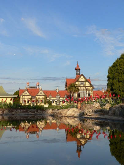
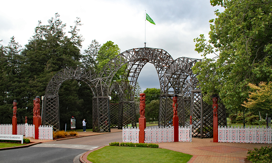
Sign up to hear more
Get the latest heritage news, features and events delivered
straight to your inbox.
