Early History
Te Tai Poutini (West Coast) has a long history of Māori occupation. Poutini was a key figure in tribal kōrero as part of the Pounamu love story and he is said to still swim along the West Coast acting as kaitiaki for the whenua and pounamu.
Sparsely populated in comparison to the east coast of Te Wai Pounamu, the resources that were available on Te Tai Poutini were nevertheless sufficient to support vibrant communities and frequent visitors. The waterways and lakes contained kākaho (toetoe stems) and tuna and the moana held enormous numbers of ika (fish) and kekeno (fur seals). Kōura (crayfish), both salt and freshwater varieties, were found in good quantities. Kiekie, harakeke, pīkao and other key vegetation provided material for weaving and trade with the dense forests prime locations for birdlife, building and carving material. The highly prized and fiercely defended pounamu resources were gathered and manufactured at places including Māwhera prior to transport along the ara tawhito. The topography of the Māwhera (Greymouth) and Māwhera-iti river valley provided excellent mahinga kai and was particularly utilised as an ara tawhito when travelling north or east.
After a series of battles with Ngāti Wairangi, Poutini Ngāi Tahu held manawhenua over Te Tai Poutini around the time Pākehā first arrived and showed interest in acquiring their resources and their lands. A controversial 1860 Arahura purchase deed saw West Coast land title transfer to the Crown although Poutini Ngāi Tahu managed to negotiate reserves including their pounamu sources and smaller reserves up the Māwhera River.
Explorer Thomas Brunner (1821?-1874) recorded coal in the Grey Gorge (‘Brunner Gorge’ or ‘Coal Gorge’) in early 1848 while travelling upriver by canoe with a party of Māori from Māwhera Pa. Within fifteen years, industrial scale mining had commenced in this area.
Brunner Mine (1864-1906)
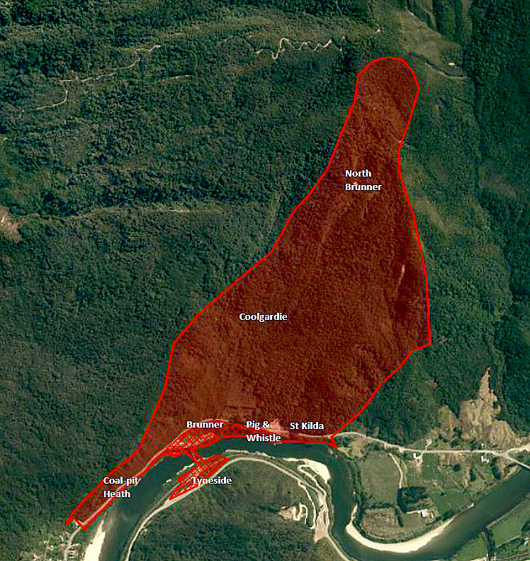
Of the many mines in the district, the Brunner mine site was developed first and most easily because of its accessibility to water transport and the angle of incline of the principal coal seam. In the earliest years of mining at Brunner, local Poutini Ngāi Tahu collected up coal and transported it to the coast in canoes, ready for sale and distribution.
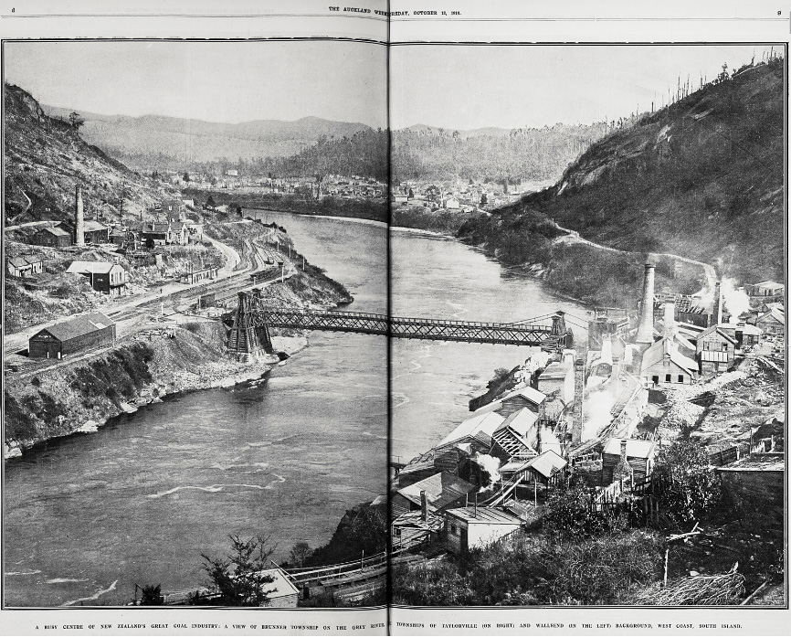
In 1864 Matthew Batty opened the Brunner mine on behalf of the Nelson Provincial Government, which was interested in exploiting coal resources within their province to supply the growing domestic and industrial demand. In 1866 the mine was taken over by the Nelson Coalmining Company where they established the first coke ovens on the Brunner site. The early plant was surrounded by residences and commercial buildings of Brunnerton (‘Brunner Town’) and eventually included the small township known as ‘St Kilda’ which included houses on the hills above the mine.
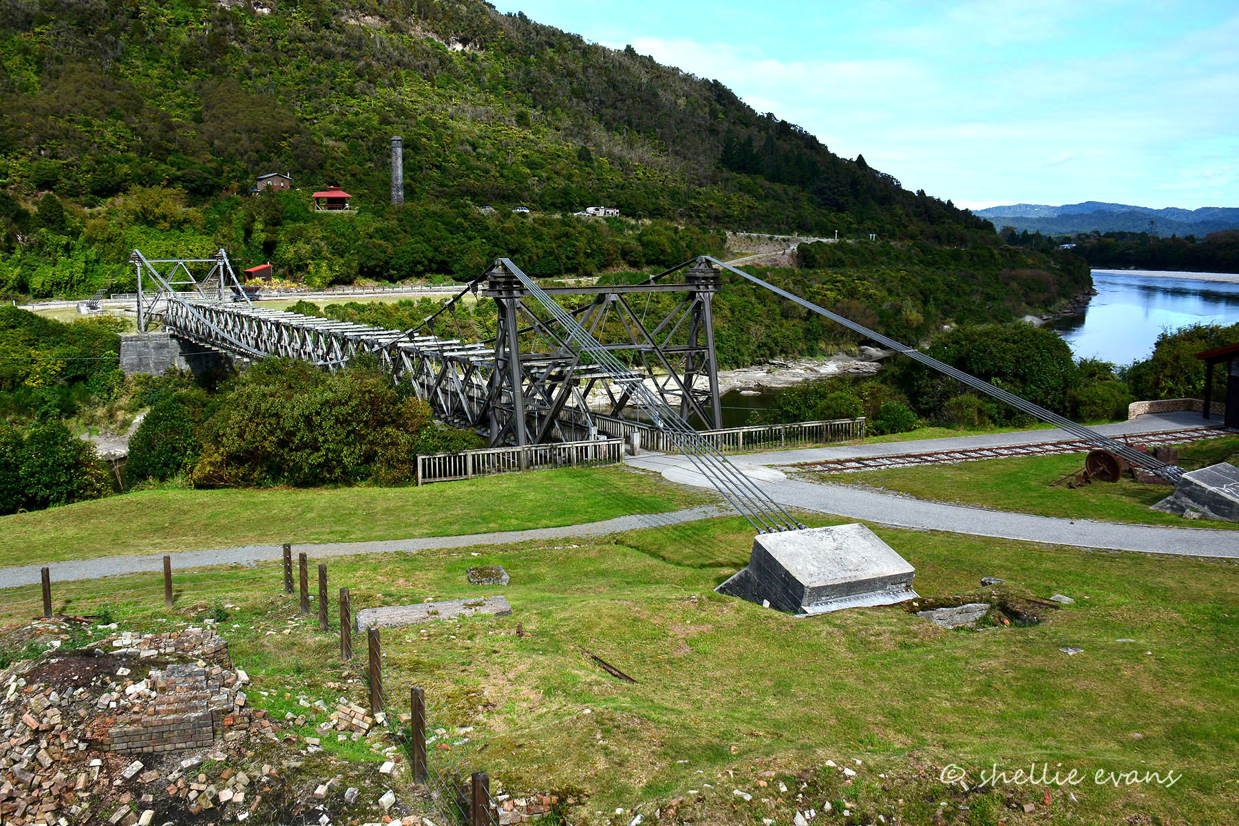
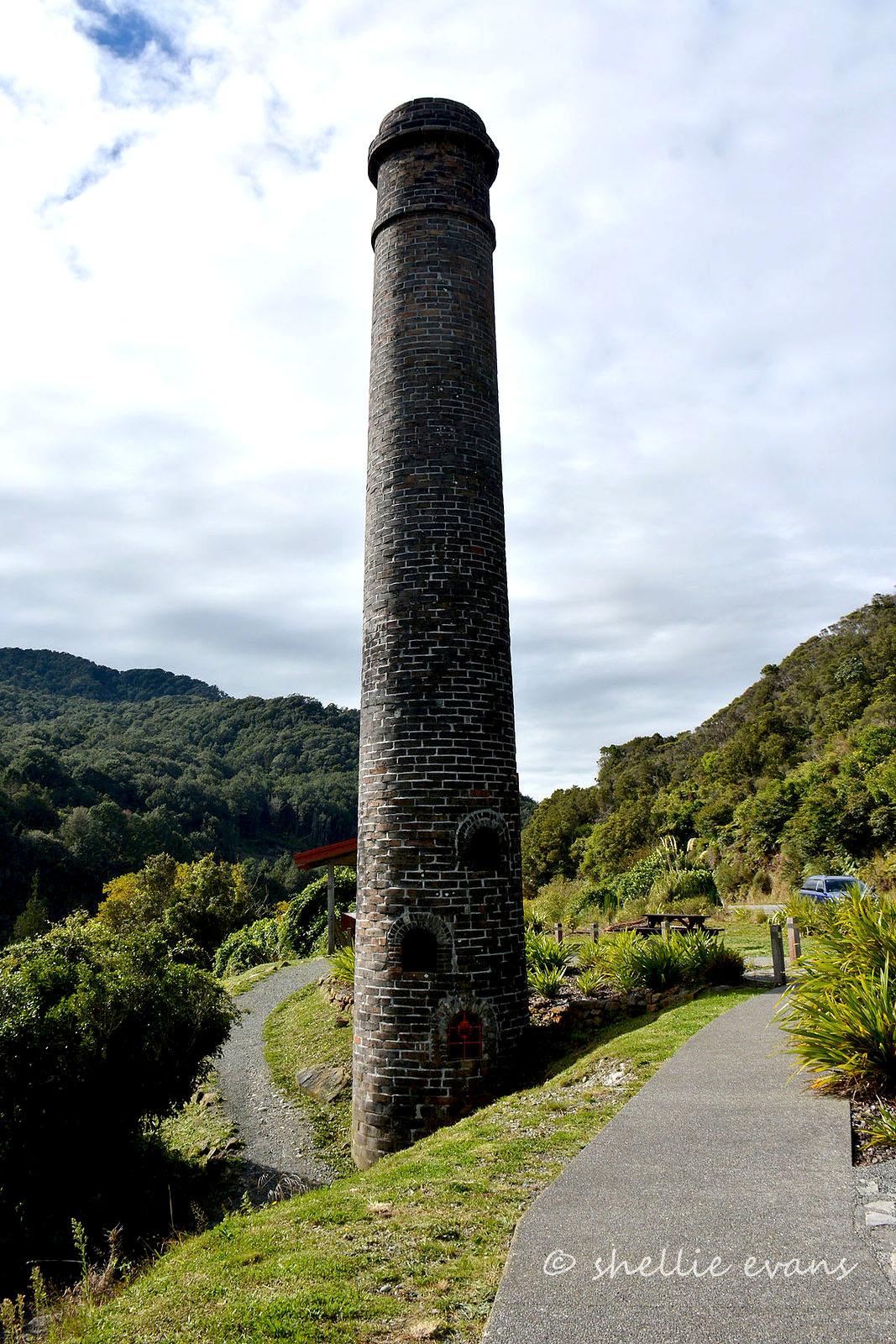
The Nelson Provincial Government operated the mine from 1868 until 1874 after which Martin Kennedy, a local merchant, took over the mine and in 1880 became its sole proprietor. It was during Kennedy’s tenure that the Brunner mine expanded the most, particularly during the 1880s. This expansion was due to a number of factors including the construction of the Greymouth-Brunner railway and the Brunner suspension bridge in 1876-7 which meant coal no longer had to be barged down river. By the 1880s the Brunner Mine was producing more coal than any other New Zealand mine, and at its peak employed more than 300 men and boys. The high quality of coke and coal from Brunner was recognised internationally. Brunner’s beehive coke ovens, based on Northern English types, were built in stages between 1868 and 1890.
The worst mining disaster in New Zealand’s history occurred at Brunner on 26 March 1896. In an explosion of gas and coal dust, 65 men and boys died, and the impact on the miners’ families lasted for generations. After the 1896 explosion the mining community felt Brunner declined, although in fact production peaked in 1901, and it was another five years after that before the main mine closed in 1906. Even after the main Brunner mine closed in 1906, other mines continued to use parts of the Brunner site and plant. When the St Kilda Mine started up in 1907, various buildings at the old Brunner site such as the blacksmith and carpenter shops were modified and moved and the old storage and screening bins came down.
Coal-pit Heath Mine (1874/5-1893)
The Coal-pit Heath Coal Mining Company, founded in 1873 by Charles Taylor and his son Joseph, was an early operation, and one of the larger in the Coal Gorge. The Coal-pit Heath Company obtained a lease of the ground to the west and to the dip of the Brunner Mine in 1875. Initially the Coal-pit Heath mine was worked by means of a rectangular shaft, sunk in 1875, approximately 300 yards (275 metres) from the end of the Brunner Bridge. A 25 x 4 feet (7.6 x 1.2 metres) Cornish boiler was installed, initially supplying steam to its 30 horse power horizontal steam engine used for both winding and pumping. As the mine was close to the river, loading operations were comparatively simple. The slopes were used to tip coal into storage bins and transfer it by way of shoots into coal trucks which then were hauled to the bridge by a 150 metre railway line. The full trucks were lowered by wire rope down a gentle slope to the Brunner sidings and empty trucks were winched back by steam. Production began in 1877 and the first coal to be trucked across the newly-built Brunner suspension bridge came out in April that year.
Initially the road between Taylorville and Brunnerton passed in front of the Coal-pit Heath mine but in the early 1880s the County Council built a road higher up.
The Coal-pit Heath Company was restructured in 1884 and the Taylors entered into mine ownership and carrying arrangements with Captain Bully Williams, owner of the Black Diamond Line. Coal-pit Heath Mine expanded in 1883-4, with the opening out of the dip workings and the installation of a pair of 30 horse power coupled horizontal haulage engines. In 1880 the Coal-pit Heath Company constructed four coke ovens using fire bricks obtained from the neighbouring Brunner Company. In 1886 the Coal-pit Heath Mine was sold to The Westport Coal Company, based out of Dunedin, bringing about the second phase of expansion in Coal Gorge. In 1886 the pumping gear was improved and a Schiele fan driven by steam power was installed. In 1887 new headgear was erected because the original became unsafe. Bins were extended to meet the increased output, and an additional chimney stack was built by 1888.
In 1889 the Westport Coal Company came to an agreement with the Grey Valley Coal Company for the Coal-pit Heath Mine to haul out its coal through the Brunner Mine. The mine’s output was redirected underground to the Brunner staging (rope haulage was provided for this in early 1890). The increase in coal output required improvements at Brunner including enlarged bins, screening plant, storage.
In 1892 a fire in the shaft at Coal-pit Heath caused damage to its plant and necessitated flooding. Ongoing water difficulties caused the mine to be abandoned in 1893.
Tyneside Mine (1874/6-1878, 1880-1881, 1885-1888, 1901-1908, 1920s, 1930-1932, 1950s)
Situated on the south side of the Grey River, opposite the Brunner mine, Tyneside Mine’s early history relates to the neighbouring Wallsend Mine, with Tyneside’s 98 foot (30 metre) shaft sunk in 1874 originally being called ‘Wallsend No. 1’. Workings were opened up from an adit alongside the river and from the foot of the shaft. A 40 horse power steam engine (from the Ross goldfield) was installed in 1874 to service the Wallsend No. 1 shaft. This was the first of the Brunner Mines to employ a steam engine in its operation. Coal from Tyneside mine was first trucked to Greymouth in July 1876.
In a similar way to Brunner opposite, Tyneside had non-mining buildings such as houses, hotels and churches which were erected close to the Tyneside mining plant. Railway infrastructure at Tyneside was key to the Brunner Mines on the northern side of the river, as coal was brought across the suspension bridge to be taken by rail to Greymouth port.
The mine operated for bursts of a few years at a time, followed by periods of inactivity. A key difficulty for the Tyneside mine was its inability to cope with water that seeped in through rocks from the Grey River.
In 1880 the mine was leased by the Westport Coal Company. Joseph Kilgour and Edmund Wickes sub-leased 70 acres in 1885. Kilgour remained closely associated with the Tyneside Mine and in 1886 acquired new plant, working from the old shaft. In 1888 the Grey Valley Coal company took over the sub-lease, though the mine closed shortly after.
In 1901 Tyneside Mine was leased to H Jones. It reopened in 1902 under the ownership of the Tyneside Proprietary Company Limited. At this time the mine was provided with modern plant including Hornsby boiler for haulage, ventilation and pumping equipment. Between 1902-7 the output from the Tyneside mine grew markedly – two sets of bins were built and the steam capacity was increased. A bricked chimney was added in 1904-5. The mine picked up many of the orders previously supplied by the Brunner Mine. Around 1907-8 was the period of largest output at Tyneside Mine.
In 1908 the mine flooded and was abandoned. Mining was attempted again in the mid 1920s before abandonment. In 1930 the Tyneside Collieries Ltd attempted to re-open the mine, but heavy inflow of surface water caused the mine to close. In 1954 Tyneside State worked the mine for three years but abandoned it.
Coolgardie Mine (1893-c1903-8, 1924-1929, 1931-1932)
A new part of the Brunner lease, the Coolgardie or Brunner Rise section, opened out in 1893 in hope for the continuation of growth in output. This was worked by the Greymouth-Point Elizabeth Railway and Coal Company in conjunction with the old Brunner mine but was not connected to it. With Government assistance, the Coolgardie Mine was the first extension of mining in Coal Gorge beyond the mines near river level to more elevated sites. Coal tubs were taken from the mine entrance by horses along a level tramway about 160 metres in length to a self-acting incline which was over 700 metres long. With the assistance of a drum and wire rope, full tubs were lowered to the Brunner staging and empty tubs were returned. Part of the Coolgardie Incline was through the old Brunner workings. A benched Coolgardie track, situated some 500 feet (152 metres) above the Brunner mine provided access to the Coolgardie Mine.
When the Brunner Mine exploded in 1896, miners from Coolgardie Mine were amongst the first on the scene and assisted in the aftermath. It was recognised as being extremely fortunate that the two mines were not physically connected, lest the death toll could have been even higher.
Workings ceased in the first decade of the 20th century. In the 1920s and early 1930s, the Coolgardie Mine was revisited by small cooperative parties. Allan and Party worked the mine between 1924 and 1927, and in 1931-32, the United Brunner Coal-mines extracted remaining pillars.
Pig and Whistle Mine (1900/1901-1910, 1924-1925, 1941)
The comparatively little known Pig and Whistle Mine operated immediately east of the old Brunner Mine for a short time between 1900 and 1910.
In 1924 and 1925 Boustridge and Party attempted to work the mine but it was abandoned due to movements of an old slip. These above ground hazards continued to be an issue. In 1941 S A Fry attempted to work the mine for the United Brunner Coal Mines but further landslides made mining impossible.
St Kilda Mine (1907-1921)
The St Kilda section of the Brunner mine was opened at outcrops 400 metres upstream from the suspension bridge. Although they were first investigated in 1891-2 and a horse drawn tramway was built, mining did not proceed until 1907, the year after the main Brunner mine closed. The Greymouth-Point Elizabeth Railway and Coal Company operated the mine at this time. This brought a new phase, albeit a fairly short-lived one, of development at Coal Gorge and the Brunner mine site. Many parts from the Brunner site were recycled for use at the St Kilda mine. The development took place east of the Brunner coke ovens – and new 200 ton capacity bins and screening plant recycled from Brunner were erected. Surface haulage by a steam driven winch using the engine of the old Brunner Schiele fan brought 6 to 8 tubs at a time back to the bins. Steam from the Brunner mine also supplied power to drive the screening plant. St Kilda had several mine entrances: one was at bins level, and another at river level - the latter required the installation of boiler and ventilation plant (Sirocco fan driven by oil engine and Pelton wheel).
The Brunner beehive coke ovens and fireclay works continued production as part of the St Kilda operations. Tyneside Proprietary Ltd purchased the Brunner lease in 1911 and, as owners of the St Kilda mine, they made full use of the Brunner trademark. The St Kilda Mine produced a ‘fair quantity’ of very high quality coke through until the start of the First World War. The mine was exhausted in 1921.
North Brunner Mine (Stony Creek 1909-1912) (Top Mine 1907-1929, 1910-1920, c1922-23)
Set high up on the Paparoa range, north east of Coolgardie Mine and St Kilda Mine, opposite Stillwater, the establishment of the North Brunner Mine was a considerable enterprise requiring heavy capital expenditure. D E Thornton had leased the area in 1904, and in 1907 the mine was prospected. The North Brunner Coal Co Ltd took over in 1908, and began to produce coal in 1910 from two separate sections.
Set at 1,385 feet (422 metres) above sea level, the mine required construction of an endless rope incline for haulage on a gradient of 1:12 over a distance of nearly 2.5 kilometres to bring coal across a new Grey River bridge near Stillwater. Gravity was the power used on the incline tramway for drawing the coal and getting it down to the lower bins by the present Taylorville/Blackball Road. Machinery was powered by a multi-tubular boiler and a 9 inch (22 centimetres) stroke horizontal steam engine. The North Brunner mine’s main tunnel, 10 foot by seven foot (3 by 2.1 metres), was level for some way then the drive dipped at one in three. The mine was ventilated by a fan and all machinery was installed outside the tunnel. Coal output began in 1910 but the quality of coal was not as good and the yield was variable. Fireclay from the mine was brought back over the Brunner bridge to the Brunner brickworks.
Two sections were worked: Stony Creek and The Top Mine, with miners’ access usually by the old Coolgardie track. Miners camped in huts during the week and returned to Taylorville at weekends.
The North Brunner Mine was fraught with problems. One of the difficulties was the problem in obtaining replacements for the long wire ropes, along with coal royalty issues. In addition, the coal seams were less continuous and therefore less accessible than other parts of Coal Gorge. The coal from North Brunner was not the high standard of the original Brunner mine, being described as ‘very soft and friable’ and unsuitable for handling and shipments. The Stony or Cliff section was exhausted within two or three years, but the Top Mine section was worked until 1920. Another short burst of activity occurred in the early 1920s. The main mine entrance to North Brunner subsequently collapsed.
Cooperative Mining
The exploitation of small areas of easily accessible coal at Coal Gorge by co-operative mining parties started in 1921. The Cooperative mines utilised some of the existing plant. As the readily accessible coal deposits became exhausted, the costs increased and so financial assistance was provided to the co-operative groups, either by the State or from private sources. In 1945 there were 15 co-operative mines working in the wider Greymouth Coalfield and by this time they were recognised as being less distinct from small privately-owned collieries.
Post-mining period
After mining finally ceased, the mine sites and structures gradually became covered in scrub. Demolition of and removal of some of Brunner’s plant and buildings began in about 1936 and Tyneside had most of its mine buildings and plant removed by late 1937. By 1955 only one chimney on the Brunner site was still standing, and across the way the Tyneside chimney remains.
The plant became decayed. Native vegetation regenerated, and in the former St Kilda township area introduced species also flourished.
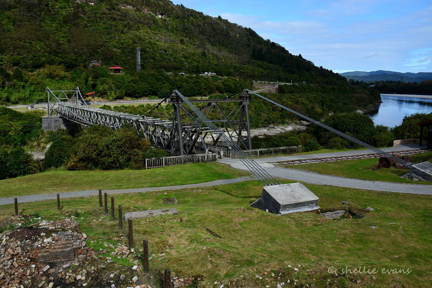
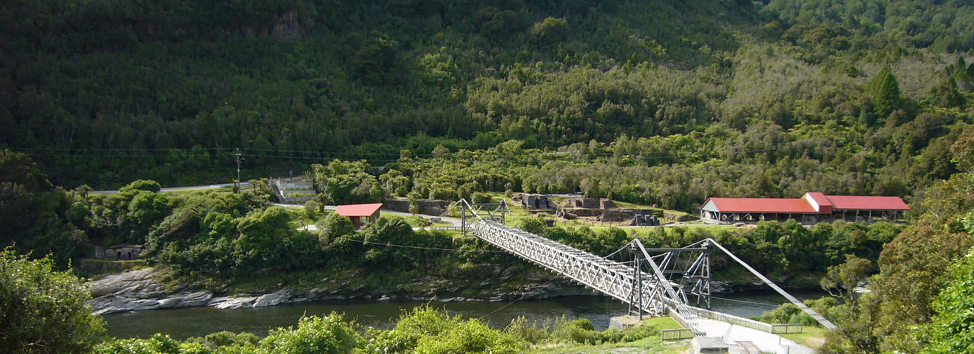
Parts of the suspension bridge were renewed and strengthened in 1927. In 1962-69 further replacements and alterations were carried out to strengthen and widen the bridge.
In the 1970s key features at Brunner and Tyneside became the focus of early conservation efforts by the local community and the New Zealand Historic Places Trust (Heritage New Zealand). In 1996 the Suspension Bridge was closed due to deterioration and subsequently a major programme of restoration and reconstruction resulted in the bridge reopening as a pedestrian way in 2004.
A visitor experience walkway connecting the various Coal Gorge mine sites was developed by the Walkways Commission from 1980. The walkway experience was closed in 2006, in part due to safety concerns.
A memorial statue to those who lost their lives in the Brunner Mine Disaster was erected on the Brunner site as part of the centennial commemoration in 1996.
The main riverside parts of the Brunner and Tyneside sites, connected by the suspension bridge, remain a popular visitor attraction, receiving 30,000 visitors annually.
Contextual Summary
Power from coal enabled Britain’s industrial revolution, and in colonies such as New Zealand, exploitation of the resource was a key focus. In the mid nineteenth century, the country's governing bodies were eager to exploit mineral resources available in their new land. Nelson Provincial Council commenced the industrial scale extensive coal extraction and other operations were soon established, assisted by infrastructure development both at ‘Coal Gorge’ and at Greymouth Port.
On the West Coast, coal became important for the prosperity of the Grey County as alluvial gold-mining declined. The Coal export trade was very important for the region – Denniston and Coal Gorge mines being pivotal – and was aided by the improved harbour facilities and railways.
As such these mines played a major role in the nineteenth century vision of New Zealand as being ‘Britain of the South’, following the industrial advances of the United Kingdom.
In the 1880s the various Brunner Mines at Coal Gorge supplied more than half of New Zealand’s high grade bituminous coal which was essential for steam raising (including for locomotives), gas works and foundry use. Coke was used in foundries and for gold assays. Fireclay associated with the coal seams was economically important too – Brunner’s fire brick products were used for both domestic and industrial use, as well as for sanitary pipes for sewerage and drainage systems.
System of Coal-winning
Most of the mines were developed by drives in out-cropping seams or by adits up to around one kilometre long tapping one or more workable seams. The system of mining was generally ‘bord and pillar’, under which the coal was cut away from spaces, called ‘bords’ or ‘boards’, leaving solid ‘pillars’ of coal. Miners first extracted coal along roadways (tunnels) or bords, while the coal in between the bords acted as pillars (walls of coal) holding up the roof. Then the outer pillars were mined, leaving the roof to collapse in a controlled way as miners retreated to the exit. Two or three parallel headings were driven to the dip or to the rise (generally at a right angle to the strike of the seam) – from these main headings, bords were driven and connected by stentons to form pillars. Due to the prevalence of gas, artificial ventilation was provided by fans.
Coking
Coke, the derivative produce of bituminous coal produced by destructive distillation, contains a higher carbon content and fewer impurities than coal and burns with no smoke. The major use for coke is as a metallurgical fuel. At Brunner, coal slack was heated slowly in the beehive coke ovens over a period of three days and then bagged on the adjacent platform.