

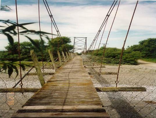
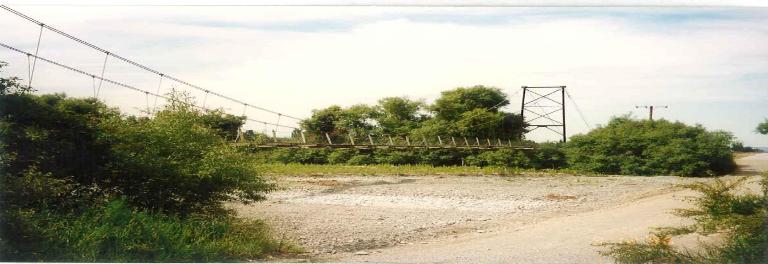
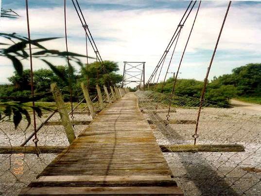
Tuahiwi is the home of Ngāi Tūāhuriri and has played a vital role in Ngāi Tahu history. The takiwā (district) of Te Ngāi Tūāhuriri Rūnanga centres on Tuahiwi and extends from the Hurunui to the Hakatere river and inland to the Main Divide. Nearby the famous Kaiapoi Pā was established by the first Ngāi Tahu ancestors when they settled Te Wai Pounamu. Kaiapoi Pā was the major capital, trading centre and point from which further penetration of the South Island occurred so the area is a genealogical centre for all Ngāi Tahu whānui (descendants). Kaiapoi Pā was established by Moki’s elder brother Tūrākautahi who was the second son of Tūāhuriri, hence ‘Ngai Tūāhuriri’ is the name of the hapū of this area. Ō-pahu (pit or waterhole) and Wai-a-Rariki are names associated with the general area near where the Wolffs Road Suspension Bridge was later built. Rudolph George Wolff purchased land on the north bank of the Eyre River on 19 July 1937 and soon after designed the suspension footbridge. Construction was delayed by the outbreak of the Second World War. Construction was eventually begun in 1945 and continued, as time permitted, until 1948. R. G. Wolff built the bridge himself, with help from his family and various neighbours in the Horrelville District. The Wolff family were well known in the district, the ford and road being named after them.
The basic design of the wire rope suspension bridge was adapted from a standard Public Works Department plan, the final design and specifications being checked by Professor Calvert of the Engineering Department of Canterbury University College. The plans are believed to be the same as a bridge over the Mangakahia River in Northland. The towers for the Wolffs Road Suspension Bridge were fabricated from tram rails that had been taken up from the streets of Christchurch when the Transport Board made the change from trams to buses. The main suspension cables used for the bridge had been purchased from the war Assets Realisation Board. The main span of the bridge is 73 metres.
Users of the bridge frequently took sacks of potatoes, peas and other grain across in sack barrows. It was also used to carry cans of cream, and to allow distribution of daily mail and newspapers to residents on the south side of the river. The Eyrewell Forest Camp Village, which at one time numbered around 200 residents, used it for getting such provisions. In a major flood of 1951, both the top (Oxford) and bottom (Ōhoka) car bridges were washed out. The Wolffs Road Suspension Bridge footbridge was the only access for people living on the south side of the river between View Hill and Manderville. Oxford provisions were brought across the bridge for View Hill people. The bridge and land were given to the Eyre County Council by the Wolff family in 1978. Later, in 1983, a car bridge was built on Poyntz Road, on the next ford downstream. In 2021, the timber deck is deteriorating and the structure is no longer used as a pedestrian footbridge.
List Entry Information
Status
Listed
List Entry Status
Historic Place Category 2
Access
Private/No Public Access
List Number
7143
Date Entered
24th February 1994
Date of Effect
24th February 1994
City/District Council
Waimakariri District
Region
Canterbury Region
Extent of List Entry
Extent includes the land described as RS 37131 (RT CB491/216) and Pt RS 15417 (RT CB451/218), Canterbury Land District and the structure known as Wolffs Road Suspension Bridge spanning the Eyre River between those land parcels.
Legal description
RS 37131 (RT CB491/216) and Pt RS 15417 (RT CB451/218), Canterbury Land District
Construction Professional
Name
Wolff, R.G.
Type
Builder
Biography
No biography is currently available for this construction professional
Construction Details
Start Year
1936
Finish Year
1937
Type
Designed
Description
Plans prepared, based on orthodox Public Works design. Plans checked by Prof. A Calvert of Canterbury College. Construction delayed by WWII
Start Year
1945
Finish Year
1948
Type
Original Construction
Description
Bridge constructed.
Construction Materials
Wire rope suspension bridge with four steel towers on concrete bases. Materials; Timber, wire rope, steel, concrete
This historic place was registered under the Historic Places Act 1993. The following text is from the N.Z Historic Places Trust Building Record form researched by Mr B S Kingsbury and included with the Proposal for Classification at the time of registration. The Wolff family were of local significance in the area as the ford and road are both named after them. Rudolph George Wolff purchased land on the north bank of the Waimakariri River on 19 July 1937 and according to RG Wolff's son John, the suspension footbridge was designed that year. Construction was delayed by World War II, commencing 1945 and continuing as time permitted until 1948. In the flood of 1951, both the top (Oxford) and bottom (Ohoka) car bridges were washed out. This footbridge was the only access for people living on the south side of the river between View Hill and Manderville. Oxford provisions were brought across the bridge for View Hill people. The Eyrewell Forest Camp Village, which at one time numbered c200 residents, used it for getting mail and provisions. The bridge and land were given to the Eyre County Council by the Wolff family in 1978. At present (1992) the council are not maintaining the bridge and they do not want residents or people to use it because of its condition. A car bridge was built on Poyntz Road, on the next ford downstream, in 1983. Wolff's Road Suspension Bridge is an example of self help (Kiwi ingenuity) when the local authority was not in a position to do so.
This historic place was registered under the Historic Places Act 1993. The following text is from the N.Z Historic Places Trust Building Record form researched by Mr B S Kingsbury and included with the Proposal for Classification at the time of registration. The Wolff family were of local significance in the area as the ford and road are both named after them. Rudolph George Wolff purchased land on the north bank of the Waimakariri River on 19 July 1937 and according to RG Wolff's son John, the suspension footbridge was designed that year. Construction was delayed by World War II, commencing 1945 and continuing as time permitted until 1948. In the flood of 1951, both the top (Oxford) and bottom (Ohoka) car bridges were washed out. This footbridge was the only access for people living on the south side of the river between View Hill and Manderville. Oxford provisions were brought across the bridge for View Hill people. The Eyrewell Forest Camp Village, which at one time numbered c200 residents, used it for getting mail and provisions. The bridge and land were given to the Eyre County Council by the Wolff family in 1978. At present (1992) the council are not maintaining the bridge and they do not want residents or people to use it because of its condition. A car bridge was built on Poyntz Road, on the next ford downstream, in 1983. Wolff's Road Suspension Bridge is an example of self help (Kiwi ingenuity) when the local authority was not in a position to do so.
Builder and owner: Rudolf George Wolff
Builder and owner: Rudolf George Wolff
Historical and Associated Iwi / Hapū / Whānau
Completion Date
25th June 2021
Report Written By
Robyn Burgess
Other Information
A copy of the original report and summary upgrade report is available from the Canterbury/West Coast Area Office of Heritage New Zealand Pouhere Taonga. Please note that entry on the New Zealand Heritage List/Rarangi Korero identifies only the heritage values of the property concerned, and should not be construed as advice on the state of the property, or as a comment of its soundness or safety, including in regard to earthquake risk, safety in the event of fire, or insanitary conditions.
Former Usages
General Usage: Transport
Specific Usage: Bridge/ Viaduct
Former Usages
General Usage: Transport
Specific Usage: Bridge/ Viaduct
Location
Sign up to hear more
Get the latest heritage news, features and events delivered
straight to your inbox.
