DonateSupporterVisit Heritage
  • Tūrangawaewae
    Places
  • Tira Māori
    Māori Heritage
  • Poutairangahia
    Archaeology
  • Rauemi
    Resources
  • Mō Tātou
    About Us
  • New Zealand Heritage List
  • Nominate and submit
  • Explore the List
  • National Historic Landmarks
  • Plaques
  • Rainbow List Project
  • Lost heritage
  • Visit Heritage
  • Our properties
  • Turnbull House Project
  • Collections
  • Shop
  • Tohu Whenua
  • Tira Māori
  • Conserving Māori heritage
  • Marae built heritage
  • Māori heritage on the List
  • Hinemihi—Te Hokinga Mai
  • What is archaeology?
  • Is there a site on my property?
  • What are my legal requirements?
  • Affecting an archaeological site
  • Declaring an archaeological site
  • Archaeology FAQs
  • Archaeology Digital Library
  • Archaeology guidelines and templates
  • Resources
  • Funding
  • Publications
  • Sustainable management guides
  • Disaster recovery
  • Podcasts & digital resources
  • Education Hub
  • Conservation plans
  • About
  • Board
  • Māori Heritage Council
  • Senior Staff
  • Offices
  • Contact us
  • Careers
  • Covenants
  • Fast-track
  • Corporate documents
  • Currently consulting on
  • Our submissions
  • News
Quick links
Rārangi Kōrero | The List
Explore the List
National Historic Landmarks
Ngā Manawhenua o Aotearoa me ōna Kōrero Tūturu
Quick links
Tapuwae
A Vision for Places of Māori Heritage
Funding for Māori Heritage
Resources
Quick links
Archaeological Authority Portal
Applying for an archaeological authority
Archaeology FAQs
Browse the most frequently asked questions about archaeological authorities and the archaeological process.
Quick links
Quick links
Contact us
Offices
DonateSupporterVisit Heritage
  • Tūrangawaewae
    Places
  • Tira Māori
    Māori Heritage
  • Poutairangahia
    Archaeology
  • Rauemi
    Resources
  • Mō Tātou
    About Us
  • New Zealand Heritage List
  • Nominate and submit
  • Explore the List
  • National Historic Landmarks
  • Plaques
  • Rainbow List Project
  • Lost heritage
  • Visit Heritage
  • Our properties
  • Turnbull House Project
  • Collections
  • Shop
  • Tohu Whenua
  • Tira Māori
  • Conserving Māori heritage
  • Marae built heritage
  • Māori heritage on the List
  • Hinemihi—Te Hokinga Mai
  • What is archaeology?
  • Is there a site on my property?
  • What are my legal requirements?
  • Affecting an archaeological site
  • Declaring an archaeological site
  • Archaeology FAQs
  • Archaeology Digital Library
  • Archaeology guidelines and templates
  • Resources
  • Funding
  • Publications
  • Sustainable management guides
  • Disaster recovery
  • Podcasts & digital resources
  • Education Hub
  • Conservation plans
  • About
  • Board
  • Māori Heritage Council
  • Senior Staff
  • Offices
  • Contact us
  • Careers
  • Covenants
  • Fast-track
  • Corporate documents
  • Currently consulting on
  • Our submissions
  • News
Quick links
Rārangi Kōrero | The List
Explore the List
National Historic Landmarks
Ngā Manawhenua o Aotearoa me ōna Kōrero Tūturu
Quick links
Tapuwae
A Vision for Places of Māori Heritage
Funding for Māori Heritage
Resources
Quick links
Archaeological Authority Portal
Applying for an archaeological authority
Archaeology FAQs
Browse the most frequently asked questions about archaeological authorities and the archaeological process.
Quick links
Quick links
Contact us
Offices
  • Places
  • Nominate and submit
  • National Historic Landmarks
  • Places
  • Nominate and submit
  • National Historic Landmarks
  • Tira Māori
  • Conserving Māori heritage
  • Marae built heritage
  • Tira Māori
  • Conserving Māori heritage
  • Marae built heritage
  • Archaeological authorities
  • Archaeology Digital Library
  • Archaeological authorities
  • Archaeology Digital Library
  • All resources
  • Publications
  • Funding
  • All resources
  • Publications
  • Funding
  • FAQs
  • FAQs
Follow us on:
Places
  • Places
  • Nominate and submit
  • National Historic Landmarks
Tira Māori
  • Tira Māori
  • Conserving Māori heritage
  • Marae built heritage
Archaeology
  • Archaeological authorities
  • Archaeology Digital Library
Resources
  • All resources
  • Publications
  • Funding
FAQs
  • FAQs
Follow us on
HomePrivacyTerms and conditionsAbout this site
© Heritage New Zealand Pouhere Taonga 2026.
 
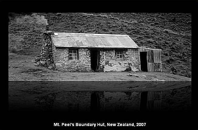
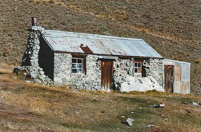
Mount Peel Boundary Hut

Ben McLeod Station, Rangitata Gorge Rd, SOUTH CANTERBURY

Private

Historic Place Category 1

List No. 7182

Quick links:
List GalleryLocationDetails
Mount Peel Boundary Hut | Mari Hill Harpur | Mari Hill Harpur Photography
Mount Peel Boundary Hut. Image included in Field Record Form Collection | C Cochran | 10/05/1991 | Heritage New Zealand Pouhere Taonga
Mount Peel Boundary Hut | Mari Hill Harpur | Mari Hill Harpur Photography
Mount Peel Boundary Hut. Image included in Field Record Form Collection | C Cochran | 10/05/1991 | Heritage New Zealand Pouhere Taonga

List Entry Information

Overview

Status
Listed

List Entry Status
Historic Place Category 1

Access
Private/No Public Access

List Number
7182

Date Entered
23rd June 1994

Date of Effect
23rd June 1994

City/District Council
Timaru District

Region
Canterbury Region

Detailed List Entry
Significance

Historic Significance

Historical Significance or Value The historical significance of Mt Peel Boundary Hut relates to its use as a boundary keeper's hut. Boundary huts appear to have been fairly common during the early years of South Island high country pastoral farming. The boundary keeping occupation was a major contributing factor in the development of large runs such as Mt Peel Station. Mt Peel Boundary Hut is a surviving example of a building type which was made redundant by technological development. In addition it was historical significance as a result of its association with Mt Peel Station and with the Acland family who were seminal features of the early history of pastoralism in New Zealand.

Physical Significance

ARCHITECTURAL QUALITY: Mt Peel Boundary Hut is a well resolved example of a New Zealand vernacular building type, the hut. Its combination of rectangular plan, symmetrical front facade and pitched roof is typical of many small scale buildings erected in colonial New Zealand. Utilitarian and simple to construct, Mt Peel Boundary Hut reflects the difficulty imposed by its remote location in the use of readily available construction materials. It is of technological interest in that the stonework is laid as random rubble in two skins with loose infill between. While the quality of workmanship is somewhat rough as befits an early building in such a remote location, the hut is remarkably sound for its age and, other than a lean-to addition, it has been little altered. TOWNSCAPE/LANDMARK VALUE: The hut is not visible from Rangitata Road but being constructed of local stone it harmonises with its tussock landscape and its river terrace setting. It commands views over Forest Creek, Moonlight Stream and parts of the Two Thumb Range.

Construction Details

Start Year

1860

Type

Original Construction

Notable Features

Stonework laid as random rubble in two skins with loose infill between

Physical Description

Builder: Possibly Alexander (Sandy) McLeod ARCHITECT/ENGINEER/DESIGNER: It is possible that the hut was designed and built by Alexander (Sandy) McLeod, a highland shepherd from Loch Broome, and/or labourers from Mt Peel Station. It was known as Sandy's Hut. ARCHITECTURAL DESCRIPTION: Mt Peel Boundary Hut is a two-roomed hut with a rectangular plan and pitched roof. The front (north) facade is symmetrical and has a centrally located door with a multi-light window on either side. The hut has a corrugated iron lean-to at the west end and a stove and chimney at the east end. MODIFICATIONS: Dates not known: -Corrugated iron lean-to added to west end -Loft floor above the bunk room partially removed

Reference

Completion Date

14th February 1994

Information Sources

Acland, 1975

L.G.D. Acland, The Early Canterbury Runs, 4th ed., Christchurch, 1975

Department of Conservation

Department of Conservation

Harte, 1956

G Harte, Mount Peel is a Hundred: the story of the first high country sheep station in Canterbury, Herald Printing Works, Timaru, 1956.

Report Written By

A copy of the original report is available from the NZHPT Southern region office Please note that entry on the New Zealand Heritage List/Rarangi Korero identifies only the heritage values of the property concerned, and should not be construed as advice on the state of the property, or as a comment of its soundness or safety, including in regard to earthquake risk, safety in the event of fire, or insanitary conditions.

Further Information

Current Usages

Uses: Civic Facilities

Specific Usage: Tramping/Mountain Hut

Former Usages

Themes

Web Links

Overview

Status

Listed

List Entry Status

Historic Place Category 1

Access

Private/No Public Access

List Number

7182

Date Entered

23rd June 1994

Date of Effect

23rd June 1994

City/District Council

Timaru District

Region

Canterbury Region

Status

Listed

List Entry Status

Historic Place Category 1

Access

Private/No Public Access

List Number

7182

Date Entered

23rd June 1994

Date of Effect

23rd June 1994

City/District Council

Timaru District

Region

Canterbury Region

Significance

Why is this place significant?

Historic Significance

Historical Significance or Value The historical significance of Mt Peel Boundary Hut relates to its use as a boundary keeper's hut. Boundary huts appear to have been fairly common during the early years of South Island high country pastoral farming. The boundary keeping occupation was a major contributing factor in the development of large runs such as Mt Peel Station. Mt Peel Boundary Hut is a surviving example of a building type which was made redundant by technological development. In addition it was historical significance as a result of its association with Mt Peel Station and with the Acland family who were seminal features of the early history of pastoralism in New Zealand.

Physical Significance

ARCHITECTURAL QUALITY: Mt Peel Boundary Hut is a well resolved example of a New Zealand vernacular building type, the hut. Its combination of rectangular plan, symmetrical front facade and pitched roof is typical of many small scale buildings erected in colonial New Zealand. Utilitarian and simple to construct, Mt Peel Boundary Hut reflects the difficulty imposed by its remote location in the use of readily available construction materials. It is of technological interest in that the stonework is laid as random rubble in two skins with loose infill between. While the quality of workmanship is somewhat rough as befits an early building in such a remote location, the hut is remarkably sound for its age and, other than a lean-to addition, it has been little altered. TOWNSCAPE/LANDMARK VALUE: The hut is not visible from Rangitata Road but being constructed of local stone it harmonises with its tussock landscape and its river terrace setting. It commands views over Forest Creek, Moonlight Stream and parts of the Two Thumb Range.

Why is this place significant?

Historic Significance

Historical Significance or Value The historical significance of Mt Peel Boundary Hut relates to its use as a boundary keeper's hut. Boundary huts appear to have been fairly common during the early years of South Island high country pastoral farming. The boundary keeping occupation was a major contributing factor in the development of large runs such as Mt Peel Station. Mt Peel Boundary Hut is a surviving example of a building type which was made redundant by technological development. In addition it was historical significance as a result of its association with Mt Peel Station and with the Acland family who were seminal features of the early history of pastoralism in New Zealand.

Physical Significance

ARCHITECTURAL QUALITY: Mt Peel Boundary Hut is a well resolved example of a New Zealand vernacular building type, the hut. Its combination of rectangular plan, symmetrical front facade and pitched roof is typical of many small scale buildings erected in colonial New Zealand. Utilitarian and simple to construct, Mt Peel Boundary Hut reflects the difficulty imposed by its remote location in the use of readily available construction materials. It is of technological interest in that the stonework is laid as random rubble in two skins with loose infill between. While the quality of workmanship is somewhat rough as befits an early building in such a remote location, the hut is remarkably sound for its age and, other than a lean-to addition, it has been little altered. TOWNSCAPE/LANDMARK VALUE: The hut is not visible from Rangitata Road but being constructed of local stone it harmonises with its tussock landscape and its river terrace setting. It commands views over Forest Creek, Moonlight Stream and parts of the Two Thumb Range.

Construction Information

Construction Details

Start Year

1860

startYearCirca

Type

Original Construction

Notable Features

Stonework laid as random rubble in two skins with loose infill between

Construction Details

Start Year

1860

startYearCirca

Type

Original Construction

Notable Features

Stonework laid as random rubble in two skins with loose infill between

Physical Description

Builder: Possibly Alexander (Sandy) McLeod ARCHITECT/ENGINEER/DESIGNER: It is possible that the hut was designed and built by Alexander (Sandy) McLeod, a highland shepherd from Loch Broome, and/or labourers from Mt Peel Station. It was known as Sandy's Hut. ARCHITECTURAL DESCRIPTION: Mt Peel Boundary Hut is a two-roomed hut with a rectangular plan and pitched roof. The front (north) facade is symmetrical and has a centrally located door with a multi-light window on either side. The hut has a corrugated iron lean-to at the west end and a stove and chimney at the east end. MODIFICATIONS: Dates not known: -Corrugated iron lean-to added to west end -Loft floor above the bunk room partially removed

Builder: Possibly Alexander (Sandy) McLeod ARCHITECT/ENGINEER/DESIGNER: It is possible that the hut was designed and built by Alexander (Sandy) McLeod, a highland shepherd from Loch Broome, and/or labourers from Mt Peel Station. It was known as Sandy's Hut. ARCHITECTURAL DESCRIPTION: Mt Peel Boundary Hut is a two-roomed hut with a rectangular plan and pitched roof. The front (north) facade is symmetrical and has a centrally located door with a multi-light window on either side. The hut has a corrugated iron lean-to at the west end and a stove and chimney at the east end. MODIFICATIONS: Dates not known: -Corrugated iron lean-to added to west end -Loft floor above the bunk room partially removed

Reference

Historical and Associated Iwi / Hapū / Whānau

Completion Date

14th February 1994

Information Sources

Acland, 1975

L.G.D. Acland, The Early Canterbury Runs, 4th ed., Christchurch, 1975

Department of Conservation

Department of Conservation

Harte, 1956

G Harte, Mount Peel is a Hundred: the story of the first high country sheep station in Canterbury, Herald Printing Works, Timaru, 1956.

Other Information

A copy of the original report is available from the NZHPT Southern region office Please note that entry on the New Zealand Heritage List/Rarangi Korero identifies only the heritage values of the property concerned, and should not be construed as advice on the state of the property, or as a comment of its soundness or safety, including in regard to earthquake risk, safety in the event of fire, or insanitary conditions.

Historical and Associated Iwi / Hapū / Whānau

Completion Date

14th February 1994

Information Sources

Acland, 1975

L.G.D. Acland, The Early Canterbury Runs, 4th ed., Christchurch, 1975

Department of Conservation

Department of Conservation

Harte, 1956

G Harte, Mount Peel is a Hundred: the story of the first high country sheep station in Canterbury, Herald Printing Works, Timaru, 1956.

Other Information

A copy of the original report is available from the NZHPT Southern region office Please note that entry on the New Zealand Heritage List/Rarangi Korero identifies only the heritage values of the property concerned, and should not be construed as advice on the state of the property, or as a comment of its soundness or safety, including in regard to earthquake risk, safety in the event of fire, or insanitary conditions.

Further Information

Current Usages

Uses: Civic Facilities

Specific Usage: Tramping/Mountain Hut

Current Usages

Uses: Civic Facilities

Specific Usage: Tramping/Mountain Hut

Location

Loading
Sign up to hear more

Get the latest heritage news, features and events delivered
straight to your inbox.

Subscribe