

Situated in close proximity to Eel Pond, an important traditional mahinga kai (food gathering area) for Maori prior to European settlement, the area that would become known as Albion Square, was selected as the site for the Provincial Government Building in 1859, having been the site for a significant public meeting on self-government in 1850. The land which would make up Albion Square was granted from the Crown to the Superintendent of Nelson, in various parcels, between 1856 and 1871.
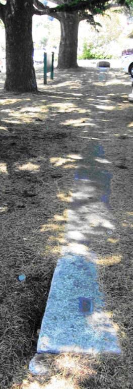
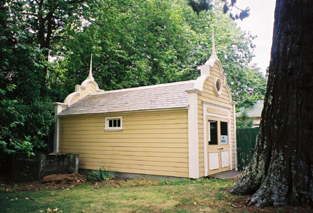
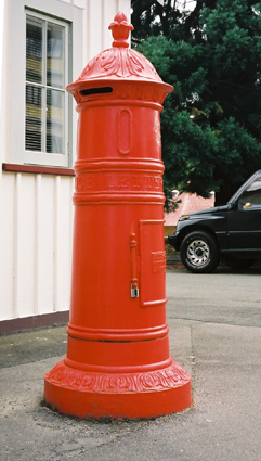
During the Provincial Government era a number of structures were erected in the grounds of Albion Square in addition to the Provincial Government buildings. These included the Hardy Street Girls' School (Former), the Caretaker's house, the Fire Engine House, the Brick Magazine, the Pillar Letter Box and Trout Hatchery all of which can still be found in the area today. A dog house, an observatory and a timber magazine are also recorded as having been in the area during this era but they no longer remain. The survey test marks on Bridge Street were laid shortly after the dissolution of the Provincial Government in 1875.
Many of the buildings erected during the Provincial Government era would continue to be used for government purposes after this time. The Provincial Government buildings became government offices while many of the other structures were used for storage by government departments. A number of new structures would also be built on or around the area from this time, for example a garrison band rotunda was erected between 1903 and 1907. The demolition of the former Provincial Government buildings in 1969 and the construction of the new Courthouse in 1974 can be considered the culmination of another period of significant change to the area. Since 1990/1991 parts of Albion Square have been actively managed by the Department of Conservation (DOC) as Historic Reserve. Other parts of Albion Square remain Government Buildings Reserve or are privately owned.
Albion Square is rare example of a site associated with many key events and activities involved in early Nelson and early New Zealand settlement. Of note are elements that represent the development of education, surveying, the militia and the postal service in the area. The area also reflects both the beginning of the Provincial Government era and its dissolution on the introduction of centralised government. Albion Square is also rare by virtue of the rarity of the significant elements gathered within it. Few other examples of the elements, including the Pillar Letter Box, the Brick Magazine, Survey Test Marks and Trout Hatchery, remain in New Zealand today and certainly not within such a concentrated place.

List Entry Information
Status
Listed
List Entry Status
Historic Area
Access
Able to Visit
List Number
7201
Date Entered
23rd June 1994
Date of Effect
23rd June 1994
City/District Council
Nelson City
Region
Nelson Region
Extent of List Entry
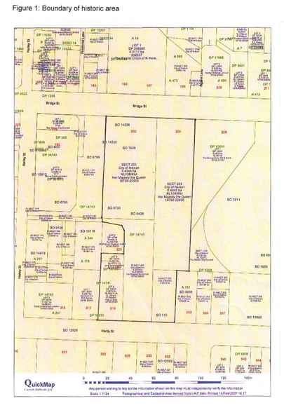
The registration includes the buildings and areas noted in the Registration Report on Appendix 3; Figure 3 including the Hardy Street Girls School (former), the Caretaker's house, the Fire Engine House, Magazine, Pillar Letter Box, Survey Test Marks and Trout Hatchery and Notable Trees, garden and setting. Registration excludes other structures on the site.
Legal description
Pt Sec 200 City of Nelson (RT NL10/664), Sec 201 City of Nelson (RT NL10/664), Pt Sec 202 City of Nelson (RT NL10/664), Sec 203 City of Nelson (RT NL10/664), Lot 2 DP19225 (RT NL12C/1114), Lot 3 DP19225 (NL 10C/730), and Part Legal Road, Nelson Land District.
Status
Listed
List Entry Status
Historic Area
Access
Able to Visit
List Number
7201
Date Entered
23rd June 1994
Date of Effect
23rd June 1994
City/District Council
Nelson City
Region
Nelson Region
Extent of List Entry
The registration includes the buildings and areas noted in the Registration Report on Appendix 3; Figure 3 including the Hardy Street Girls School (former), the Caretaker's house, the Fire Engine House, Magazine, Pillar Letter Box, Survey Test Marks and Trout Hatchery and Notable Trees, garden and setting. Registration excludes other structures on the site.
Legal description
Pt Sec 200 City of Nelson (RT NL10/664), Sec 201 City of Nelson (RT NL10/664), Pt Sec 202 City of Nelson (RT NL10/664), Sec 203 City of Nelson (RT NL10/664), Lot 2 DP19225 (RT NL12C/1114), Lot 3 DP19225 (NL 10C/730), and Part Legal Road, Nelson Land District.
Why is this place significant?
Cultural Significance
Traditional Land in and around Albion Square, including Section 203 and 205, close to Eel Pond, and other sections along the Matai River were were significant mahinga kai (food gathering areas) for Maori. Their significance was recognised by the Native Trustee with these sites being among the first town section tenths reserves assigned in Nelson. Social Albion Square is of considerable significance to the development of Nelson society. The site bore witness to the first steps, beginning, decline and eventual dissolution of Provincial Government in the area. It has also remained a significant centre of government in the area with the site currently home to the Courthouse, Police Station and government agencies such as the Department of Conservation. Members of the Nelson community hold Albion Square in considerable esteem. In the past there has been opposition from the community to activities that altered the character of the site, including the demolition of the Provincial Buildings and the erection of the Ministry of Works workshop and garages. Summary of Significance: Albion Square is rare example of a site associated with many key events and activities involved in early Nelson and early New Zealand settlement. Of note are elements that represent the development of education, surveying, the militia and the postal service in the area. The area also reflects both the beginning of the Provincial Government era and its dissolution on the introduction of centralised government. Albion Square is also rare by virtue of the rarity of the significant elements gathered within it. Few other examples of the elements, including the Pillar Letter Box. Brick Magazine, Survey Test Marks and Trout Hatchery, remain in New Zealand today and certainly not within such a concentrated place.
Historic Significance
Historical Significance or Value Historical Albion Square has considerable historic significance for its association to early settlement in Nelson and wider New Zealand generally. It represents the beginning and the end of the Provincial Government era, during a period of activity in the 1860s - with the erection of a number of buildings including the Fire Engine House - and then of the move to a centralised government in the 1870s - with the laying of the survey test marks on Bridge Street. The significant elements within the square also tell of many activities central to early European settlement including education, surveying, the militia and volunteers, the postal service and acclimatisation. Albion Square is also associated with events of note in early New Zealand history including the Maungatapu murders.
Physical Significance
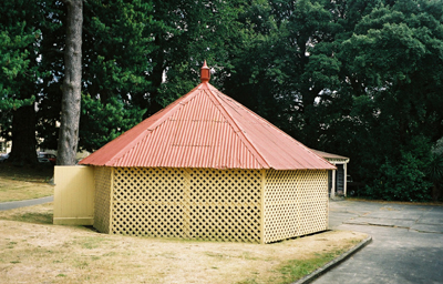
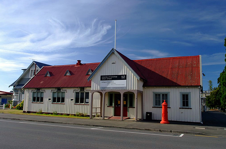
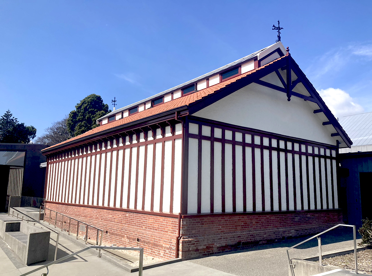
Architectural Though the largest and architecturally significant building on the site, the Provincial Buildings, were demolished in 1969 both the Hardy Street Girls' School (Former) and the Fire Engine House have architectural merit and they are also significant for their association with architect Maxwell Bury, a prominent architect in Nelson, Christchurch and Dunedin during early settlement. The Hardy Street Girls School having been designed by Bury and the Fire Engine House being inspired by his design of the Provincial Buildings. The letterbox is architecturally interesting for its unique blend of British and Australian characteristics, as is the Brick Magazine for its method of construction. Archaeological No pre European archaeological sites have been recorded in Albion Square though this remains a possibility given its proximity to Eel Pond. Certainly the diverse activities known to have taken place on the site pre 1900 suggests it may have archaeological merit - of particular note are the ponds that once existed beside the Trout Hatchery. Though no longer visible remains of these ponds are thought to still exist below ground. Scientific The site has some scientific value for its association with the acclimatisation movement, in particular the relationship to Frank Buckland, and the development of the artificial fish hatching process that is still commemorated annually in England. Technological The site has significant technological value for its association to the discipline of surveying in particular early surveying in the Nelson district and surveying instruments and methods. Aesthetic Though impacted on by the presence of modern buildings and car park Albion Square retains aesthetic value with the presence of small-scale buildings and notable trees.
Why is this place significant?
Cultural Significance
Traditional Land in and around Albion Square, including Section 203 and 205, close to Eel Pond, and other sections along the Matai River were were significant mahinga kai (food gathering areas) for Maori. Their significance was recognised by the Native Trustee with these sites being among the first town section tenths reserves assigned in Nelson. Social Albion Square is of considerable significance to the development of Nelson society. The site bore witness to the first steps, beginning, decline and eventual dissolution of Provincial Government in the area. It has also remained a significant centre of government in the area with the site currently home to the Courthouse, Police Station and government agencies such as the Department of Conservation. Members of the Nelson community hold Albion Square in considerable esteem. In the past there has been opposition from the community to activities that altered the character of the site, including the demolition of the Provincial Buildings and the erection of the Ministry of Works workshop and garages. Summary of Significance: Albion Square is rare example of a site associated with many key events and activities involved in early Nelson and early New Zealand settlement. Of note are elements that represent the development of education, surveying, the militia and the postal service in the area. The area also reflects both the beginning of the Provincial Government era and its dissolution on the introduction of centralised government. Albion Square is also rare by virtue of the rarity of the significant elements gathered within it. Few other examples of the elements, including the Pillar Letter Box. Brick Magazine, Survey Test Marks and Trout Hatchery, remain in New Zealand today and certainly not within such a concentrated place.
Historic Significance
Historical Significance or Value Historical Albion Square has considerable historic significance for its association to early settlement in Nelson and wider New Zealand generally. It represents the beginning and the end of the Provincial Government era, during a period of activity in the 1860s - with the erection of a number of buildings including the Fire Engine House - and then of the move to a centralised government in the 1870s - with the laying of the survey test marks on Bridge Street. The significant elements within the square also tell of many activities central to early European settlement including education, surveying, the militia and volunteers, the postal service and acclimatisation. Albion Square is also associated with events of note in early New Zealand history including the Maungatapu murders.
Physical Significance
Architectural Though the largest and architecturally significant building on the site, the Provincial Buildings, were demolished in 1969 both the Hardy Street Girls' School (Former) and the Fire Engine House have architectural merit and they are also significant for their association with architect Maxwell Bury, a prominent architect in Nelson, Christchurch and Dunedin during early settlement. The Hardy Street Girls School having been designed by Bury and the Fire Engine House being inspired by his design of the Provincial Buildings. The letterbox is architecturally interesting for its unique blend of British and Australian characteristics, as is the Brick Magazine for its method of construction. Archaeological No pre European archaeological sites have been recorded in Albion Square though this remains a possibility given its proximity to Eel Pond. Certainly the diverse activities known to have taken place on the site pre 1900 suggests it may have archaeological merit - of particular note are the ponds that once existed beside the Trout Hatchery. Though no longer visible remains of these ponds are thought to still exist below ground. Scientific The site has some scientific value for its association with the acclimatisation movement, in particular the relationship to Frank Buckland, and the development of the artificial fish hatching process that is still commemorated annually in England. Technological The site has significant technological value for its association to the discipline of surveying in particular early surveying in the Nelson district and surveying instruments and methods. Aesthetic Though impacted on by the presence of modern buildings and car park Albion Square retains aesthetic value with the presence of small-scale buildings and notable trees.
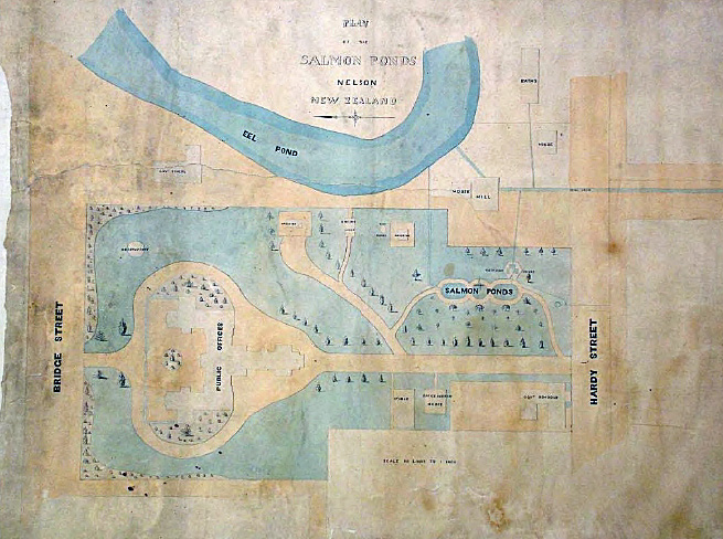
The area prior to provincial government Historical records of pre-European Nelson give detailed accounts of the sequence of Maori settlement in the Nelson region and pre-European land use. It is known that Maori had a number of sites in the area of Whakatu (now Nelson city) where they lived seasonally or on a short term basis for food harvesting. The area was not permanently inhabited between the late 1820s and 1830s and was not occupied when the New Zealand Company arrived in 1841. However, it remained an important area to Tasman Bay Maori, particularly for those living at the eastern end at Whakapuaka and other nearby settlements along the shores. In April 1842, as the New Zealand Company completed surveying the Nelson town sections, land began to be allocated to Maori and to European settlers. In 1842 part of the area that would later be known as Albion Square was set aside as a native reserve because of its proximity to Eel Pond, an important traditional mahinga kai (food gathering area) for Maori prior to European settlement. There were two categories of native reserve lands in Nelson, the tenths reserves and occupation reserves. Section 203, the land set aside as a native reserve in the area, was a town section tenths reserve. In Nelson the town section tenths reserves, defined in the New Zealand Company's articles as ten percent of the total land area purchased for the establishment of its settlement, were selected when the town survey was completed in April 1842; at the same time as the sections purchased by settlers were chosen by ballot, and the Crown reserves were set aside. The Bishop of New Zealand (Bishop Selwyn) and the Protector of Aborigines (George Clarke) appointed Henry A Thompson to make the selection of 100 one-acre Nelson Town Sections on behalf of the Natives. Thompson held several low numbers from the ballot which enabled him to secure as reserves some of the customary occupation sites and important food sources to Maori. From the 100 reserves selected Section 203 was selected 10th. Section 203 and 205, close to Eel Pond, and other sections along the Matai River were selected because these were significant mahinga kai for Maori. The land immediately surrounding Eel Pond was set aside as a crown reserve for the purposes of a meat market, this area was referred to as Reserve H. When European settlers began to arrive in the area from 1841 they found it covered in bush, scrub and swamp. The land in the area was reportedly cleared by settlers by 1843 with early sketches certainly showing that the flat land west of the Matai River was cleared by 1845. In 1844, shortly after the land was reportedly cleared, a small brick building, the Matthew Campbell School, was erected to the north-east of the area (see Appendix 6 of the registration report - Hardy Street Girls' School (Former) for further discussion on Nelson schools). In 1848, after agreement from the Governor the number of tenths reserves were reduced to 53 sections, the tenth now deemed to apply to the land sold to settlers and not that purchased from Maori. At this time Section 203 was exchanged for Section 733, a European section, to enable the Nelson School Committee [Society], who ran the Matthew Campbell School, to enlarge their premises (though no reference has been found to them ever building there). Nothing remains of the school today; in 1899 it was incorporated into the Bishop Suter Memorial Art Gallery and in 1979 it was demolished to make way for extensions to the Suter complex. To the south east of the area were a shop and a flourmill run by Matthew Campbell from the 1840s. Campbell, who was a miller by trade, leased the flourmill from 1845. Though it is commonly referred to as 'Campbell's Mill' it was actually erected by Nelson citizens in 1844 and named the Nelson Flour Mill. The mill was driven by water from Brook Stream taken to the mill along a purpose built timber aqueduct down Alton Street. The Mill was dismantled by 1887 and in 1904 the Technical School, which still stands today, was opened on that site. Apart from the visible reminder of the green area down the centre of Alton Street, all that remains of the mill is a stone lined mill race on the edge of Queens Gardens where the water is discharged into the Eel Pond. Albion Square during the Provincial Government era This area, the future site of Nelson's Provincial Government buildings, would first be the site of some of the earliest steps towards the establishment of a provincial government in New Zealand. In 27 December 1850 it was the site of a large public meeting to discuss self-government. The meeting was called by the Constitutional Society, the governance of the colony being of concern to many settlers. With no building on the site large enough to accommodate the approximately 400 who would attend a large marquee was used. The meeting was held from 12pm until 1 am (there was a break between 8 and 9pm). The meeting came out in favour of 'a federal system of government where each province had its own administration but was allied to a national administration as well'. After the Constitutional Act 1853 gave six provincial legislatures power to "make and ordain all...laws...required for the peace, order and good government”"of the provinces, the first Nelson Provincial Council was elected with Edward Stafford as Superintendent. In his opening address, held in the Courthouse - located at that time near the Church steps, the Superintendent commented that 'the absence of any sufficient Council Chamber and the offices necessarily connected with it will require that you make provision for these objects'. Though land in the area was reserved for the purposes of public utility in 1856 the Provincial Government buildings would not be completed until 1861. Some of the notable trees which remain on the site today appear to have been planted during this period (1857). In January 1858 a leader of the Masonic Lodge expressed frustration in the Examiner over the delay in gaining adequate accommodation. The paper asked: "What do we have... a Court House which is an old barn with packing cases stuck on end before it, an old Immigration Barracks where all Government Offices are located a sort of Auxiliary Hospital, a Lunatic Asylum and Refuge for the Destitute. We should have a good Council Chambers and Courthouse which might also serve for Public Meetings. Why not a quadrangle with Council Chambers in front of the Square and Magistrate's Court on one side and Post Office on the other?" In that same year the Provincial Council appointed a committee to consider 'the most expeditious and economical way of procuring a Council Chambers with the money available'. It was decided that a bonus of 25 pounds would be offered for the best design for the Government Buildings. Maxwell Bury's plan was selected (see entry in Appendix 6 of the registration report on the Hardy Street Girls' School (Former) for biography). His design was based on 'one of the finest examples of Jacobean architecture in Britain - Aston Hall near Birmingham. The construction of the Provincial Council buildings finally began in 1859 with the laying of the foundation stone on 26 August 1859 by von Hochstetter, who was doing a geological survey in Nelson at the time. A Latin inscription on the foundation stone read 'Fiat Justitia Ruat Coelum' ('Let justice be done to all, though the heavens fall'). A bottle containing items of interest from the period, including newspapers of the day, parchments containing the signatures of the government officers and the first Bishop of Nelson, and pieces of gold and coal, was laid under the stone. It was at this time that the second superintendent of Nelson, Mr John Perry Robinson, announced that the piece of ground would be known as Albion Square. Rawlence, in her article on Albion Square, notes that Albion was a name in common use at the time; meaning latin for white, it was the name given by the Romans to Britain. The Superintendent also read an extract espousing the virtues of local government and the evils of centralisation, a section of the extract read: "Local self-government makes men, everywhere, the maintainers of their own rights, liberties, independence and well-being; it breeds self respect and moral dignity. Centralisation undermines, everywhere, all those rights, liberties, independence and well-being, under the pretence of setting hired functionaries to guard them; it breeds subservient sycophancy and moral degradation". The Superintendent concluded his speech by noting that he concurred with these opinions and that he 'felt sure that the laws they passed would be for all benefit and not just for one class only'. Further notable trees that remain on the site today appear to have been planted at this time. The buildings were completed 20 months later, in 1861, at a cost of 9000 pounds, a significant sum at the time given the population was only approximately 5000. The Council first met in the buildings on 30 April 1861. There was no public ceremony for the opening; the Superintendent gave a long political speech and expressed pleasure over the building 'belonging to the people and worthy of the province'. Though Aston Hall, the building on which these buildings were based, was built of stone, the Provincial Government buildings were an ambitious timber structure. This would necessitate the presence, in future years, of a fire engine and fire engine house. Other structures erected in Albion Square during the Provincial Council era that remain today include: The Hardy Street Girls' School (Former) (1860) The Caretaker's house (c1860) The Brick Magazine (1861) The Pillar Letter Box (1862) The Fire Engine House (1866) The Trout Hatchery (1867) (A plan indicating where these structures are located can be found is in Appendix 3: Figure 3 of the registration report; further information on these structures, including a description of their location, can be found in Appendix 6 of the registration report). A dog house, an observatory and a timber magazine are also recorded as having been in the area during this era but they no longer remain (A plan indicating where these structures were located can be found in Appendix 5, Figure 1 of the registration report). The land occupied by these and the Provincial Council buildings was granted by the Crown to the Superintendent of Nelson at different times. Section 201, the site of the Provincial Buildings, was reserved for public offices on 7 June 1856. Section 200, the site of the Hardy Street Girls' School (Former) and Caretaker's Cottage was given upon trust for the public service of the Nelson Province on 2 November 1860. Part Section 202, the site of the Trout Hatchery was reserved for public utility on 3 February 1864. Finally, Section 203, the site of the Brick Magazine and the Fire Engine House was on the land that was originally native reserve but that had been exchanged for section 733 in 1848 to allow the Nelson School Society to expand its premises. Though the Brick Magazine already existed on the site the land was not purchased until 1866, presumably on the building of the Fire Engine House, and it was not granted as a site for public buildings until 5 December 1871. By the late 1860s the autonomy of Provincial Councils was waning, with central government taking measures, such as the Municipal Corporations Bills and Local Government Bill of 1867, to address 'the disorganised shambles that the local government was becoming'. Influenced by improvements in communication, continued problems financing the system and support for centralisation and local government, the provincial system was eventually abolished in 1875; "deemed to have outlived it usefulness". Though Nelson Provincial Council was scheduled to debate abolition in June 1875 this debate never took place, subsequently on 13 August 1875, the Council would pass a resolution in favour of immediate abolition. The abolition of provincial government was a significant moment in the history of governance of the country, with Bush, in his history of local government in New Zealand, noting that the "abolition of the provinces in 1875 is undoubtedly the most momentous internal constitutional change in the history of the country". The survey test marks laid near Bridge Street in 1877 were laid after the dissolution of the Provincial Government system and the introduction of a centralised government and a national survey system. Albion Square after the dissolution of Provincial Government The buildings erected during the Provincial Government era would continue to be used for government purposes from this time. The main buildings became government offices while the others were often used for storage by these departments. A number of new structures would also be built on or around the area from this time. Nearby developments included, at the end of 1886, the City Council decision to drain and reshape the Eel Pond and to form a public garden on the Eel Pond Reserve land. On 22 June 1887, the area was dedicated 'the Queens Gardens' as part of the commemoration of Queen Victoria's 50th Jubilee celebrations. The Queens Gardens were formally opened by Mayor Trask in 1891 but continued to develop over the next few years. Then in 1896 land near the Queens Gardens was gifted to the Bishop Suter Art Gallery Board of Trustees in 1896. The Suter Memorial Art Gallery, erected to commemorate the life and work of Anglican Bishop Andrew Burn Suter (1830-1895), would be built on this site in 1899. As noted the Matthew Campbell School (1844) was retained and incorporated into the design. Subsequently during redevelopment in the 1970s the school was demolished, as were the porch and steps on the eastern façade of the original Gallery. A number of other buildings would appear on the site during the twentieth century (a plan indicating where these structures are or were located can be found in Appendix 5, Figures 3 & 4 of the registration report): The band room (erected c1903-1907 demolished 1962) was used for practice by the Nelson Garrison band, built with supplies from Messrs C Leaper and the late Tom Hughes. Located close to the fire engine house and Public Works Department workshop, it was likely demolished to make way for the Ministry of Works garages in 1962, after the garrison band found new premises. The Public Works Department workshop (1936, modified c1960s) An L shaped building constructed of rimu cladding and corrugated iron cladding. It was built among some controversy over concern on encroachment in the grounds. Public Works Department old garage (pre 1939) Public Works Department paint shop (c late1930s- early 1940s) Bicycle sheds (erected between 1939-1950) Police Station (1961) erected on the corner of St John and Harley Streets it replaced a former police station on the site erected in 1868. Ministry of Works garages (1962) Public Works Department soil and water store shed (post 1952) Munro Building (1966). In 1966 the Ministry of Works proposed demolishing the Provincial Council buildings and building a new courthouse on the site. There was considerable public opposition to the demolition, including representations by the Historic Places Trust, but the cost to save it was considered too great, the building having deteriorated to the point where 'doors would not shut and joists became so rotten that they crumbled at a touch'. Though tenders were called in 1968, demolition delayed to see if Nelson could come up with a feasible retention plan. 1969 the government offered the building to the Nelson City Council with a grant of $60,000 for renovations. However the council considered it insufficient and turned it down. The building was demolished in September 1969. Dignitaries, including the descendents of the second Provincial Council Superintendent J P Robinson, attended the retrieval of the bottle laid under the foundation stone in 1859. The demolition of the old Provincial Building in 1969 and the construction of the new Courthouse in 1974 can be considered the culmination of another period of significant change to the area. The physical development of the area during this period was, perhaps like that of the Provincial Council era, largely ad hoc. A report on the development of the area from the Ministry of Works in 1981 noted that this phase of development resulted in 'a lack of coordination and unity in the area' with buildings of 'different styles and colour' and locations 'that do not fit well with circulation patterns'. It also noted that there are almost no footpaths provided and parked cars and vehicle movement dominate the Centre, with the links between the buildings being illogical and non-functional. Since 1990/1991, parts of Albion Square have been actively managed by the Department of Conservation (DOC) as Historic Reserve (see Appendix 3: Figure 4 of the registration report for the boundaries of the Historic Reserve). In its role as manager of the parts gazetted as Historic Reserve DOC has completed conservation plans for key structures and remedial work has been done on some of these, for example on the Trout Hatchery, the Fire Engine House and the Brick Magazine. Other parts of Albion Square remain Government Buildings Reserve or are privately owned. Despite DOC's efforts some of the issues highlighted by the Ministry of Works report in 1981, particularly regarding the domination of parked cars and vehicle movement in the area, remain issues today. As a result the goal outlined by that report remains the goal of the report today: 'it is hoped that this report will encourage planning which will make the best use of the historic elements and remnants of the Centre's original peaceful and spacious character for future enjoyment.'
The area prior to provincial government Historical records of pre-European Nelson give detailed accounts of the sequence of Maori settlement in the Nelson region and pre-European land use. It is known that Maori had a number of sites in the area of Whakatu (now Nelson city) where they lived seasonally or on a short term basis for food harvesting. The area was not permanently inhabited between the late 1820s and 1830s and was not occupied when the New Zealand Company arrived in 1841. However, it remained an important area to Tasman Bay Maori, particularly for those living at the eastern end at Whakapuaka and other nearby settlements along the shores. In April 1842, as the New Zealand Company completed surveying the Nelson town sections, land began to be allocated to Maori and to European settlers. In 1842 part of the area that would later be known as Albion Square was set aside as a native reserve because of its proximity to Eel Pond, an important traditional mahinga kai (food gathering area) for Maori prior to European settlement. There were two categories of native reserve lands in Nelson, the tenths reserves and occupation reserves. Section 203, the land set aside as a native reserve in the area, was a town section tenths reserve. In Nelson the town section tenths reserves, defined in the New Zealand Company's articles as ten percent of the total land area purchased for the establishment of its settlement, were selected when the town survey was completed in April 1842; at the same time as the sections purchased by settlers were chosen by ballot, and the Crown reserves were set aside. The Bishop of New Zealand (Bishop Selwyn) and the Protector of Aborigines (George Clarke) appointed Henry A Thompson to make the selection of 100 one-acre Nelson Town Sections on behalf of the Natives. Thompson held several low numbers from the ballot which enabled him to secure as reserves some of the customary occupation sites and important food sources to Maori. From the 100 reserves selected Section 203 was selected 10th. Section 203 and 205, close to Eel Pond, and other sections along the Matai River were selected because these were significant mahinga kai for Maori. The land immediately surrounding Eel Pond was set aside as a crown reserve for the purposes of a meat market, this area was referred to as Reserve H. When European settlers began to arrive in the area from 1841 they found it covered in bush, scrub and swamp. The land in the area was reportedly cleared by settlers by 1843 with early sketches certainly showing that the flat land west of the Matai River was cleared by 1845. In 1844, shortly after the land was reportedly cleared, a small brick building, the Matthew Campbell School, was erected to the north-east of the area (see Appendix 6 of the registration report - Hardy Street Girls' School (Former) for further discussion on Nelson schools). In 1848, after agreement from the Governor the number of tenths reserves were reduced to 53 sections, the tenth now deemed to apply to the land sold to settlers and not that purchased from Maori. At this time Section 203 was exchanged for Section 733, a European section, to enable the Nelson School Committee [Society], who ran the Matthew Campbell School, to enlarge their premises (though no reference has been found to them ever building there). Nothing remains of the school today; in 1899 it was incorporated into the Bishop Suter Memorial Art Gallery and in 1979 it was demolished to make way for extensions to the Suter complex. To the south east of the area were a shop and a flourmill run by Matthew Campbell from the 1840s. Campbell, who was a miller by trade, leased the flourmill from 1845. Though it is commonly referred to as 'Campbell's Mill' it was actually erected by Nelson citizens in 1844 and named the Nelson Flour Mill. The mill was driven by water from Brook Stream taken to the mill along a purpose built timber aqueduct down Alton Street. The Mill was dismantled by 1887 and in 1904 the Technical School, which still stands today, was opened on that site. Apart from the visible reminder of the green area down the centre of Alton Street, all that remains of the mill is a stone lined mill race on the edge of Queens Gardens where the water is discharged into the Eel Pond. Albion Square during the Provincial Government era This area, the future site of Nelson's Provincial Government buildings, would first be the site of some of the earliest steps towards the establishment of a provincial government in New Zealand. In 27 December 1850 it was the site of a large public meeting to discuss self-government. The meeting was called by the Constitutional Society, the governance of the colony being of concern to many settlers. With no building on the site large enough to accommodate the approximately 400 who would attend a large marquee was used. The meeting was held from 12pm until 1 am (there was a break between 8 and 9pm). The meeting came out in favour of 'a federal system of government where each province had its own administration but was allied to a national administration as well'. After the Constitutional Act 1853 gave six provincial legislatures power to "make and ordain all...laws...required for the peace, order and good government”"of the provinces, the first Nelson Provincial Council was elected with Edward Stafford as Superintendent. In his opening address, held in the Courthouse - located at that time near the Church steps, the Superintendent commented that 'the absence of any sufficient Council Chamber and the offices necessarily connected with it will require that you make provision for these objects'. Though land in the area was reserved for the purposes of public utility in 1856 the Provincial Government buildings would not be completed until 1861. Some of the notable trees which remain on the site today appear to have been planted during this period (1857). In January 1858 a leader of the Masonic Lodge expressed frustration in the Examiner over the delay in gaining adequate accommodation. The paper asked: "What do we have... a Court House which is an old barn with packing cases stuck on end before it, an old Immigration Barracks where all Government Offices are located a sort of Auxiliary Hospital, a Lunatic Asylum and Refuge for the Destitute. We should have a good Council Chambers and Courthouse which might also serve for Public Meetings. Why not a quadrangle with Council Chambers in front of the Square and Magistrate's Court on one side and Post Office on the other?" In that same year the Provincial Council appointed a committee to consider 'the most expeditious and economical way of procuring a Council Chambers with the money available'. It was decided that a bonus of 25 pounds would be offered for the best design for the Government Buildings. Maxwell Bury's plan was selected (see entry in Appendix 6 of the registration report on the Hardy Street Girls' School (Former) for biography). His design was based on 'one of the finest examples of Jacobean architecture in Britain - Aston Hall near Birmingham. The construction of the Provincial Council buildings finally began in 1859 with the laying of the foundation stone on 26 August 1859 by von Hochstetter, who was doing a geological survey in Nelson at the time. A Latin inscription on the foundation stone read 'Fiat Justitia Ruat Coelum' ('Let justice be done to all, though the heavens fall'). A bottle containing items of interest from the period, including newspapers of the day, parchments containing the signatures of the government officers and the first Bishop of Nelson, and pieces of gold and coal, was laid under the stone. It was at this time that the second superintendent of Nelson, Mr John Perry Robinson, announced that the piece of ground would be known as Albion Square. Rawlence, in her article on Albion Square, notes that Albion was a name in common use at the time; meaning latin for white, it was the name given by the Romans to Britain. The Superintendent also read an extract espousing the virtues of local government and the evils of centralisation, a section of the extract read: "Local self-government makes men, everywhere, the maintainers of their own rights, liberties, independence and well-being; it breeds self respect and moral dignity. Centralisation undermines, everywhere, all those rights, liberties, independence and well-being, under the pretence of setting hired functionaries to guard them; it breeds subservient sycophancy and moral degradation". The Superintendent concluded his speech by noting that he concurred with these opinions and that he 'felt sure that the laws they passed would be for all benefit and not just for one class only'. Further notable trees that remain on the site today appear to have been planted at this time. The buildings were completed 20 months later, in 1861, at a cost of 9000 pounds, a significant sum at the time given the population was only approximately 5000. The Council first met in the buildings on 30 April 1861. There was no public ceremony for the opening; the Superintendent gave a long political speech and expressed pleasure over the building 'belonging to the people and worthy of the province'. Though Aston Hall, the building on which these buildings were based, was built of stone, the Provincial Government buildings were an ambitious timber structure. This would necessitate the presence, in future years, of a fire engine and fire engine house. Other structures erected in Albion Square during the Provincial Council era that remain today include: The Hardy Street Girls' School (Former) (1860) The Caretaker's house (c1860) The Brick Magazine (1861) The Pillar Letter Box (1862) The Fire Engine House (1866) The Trout Hatchery (1867) (A plan indicating where these structures are located can be found is in Appendix 3: Figure 3 of the registration report; further information on these structures, including a description of their location, can be found in Appendix 6 of the registration report). A dog house, an observatory and a timber magazine are also recorded as having been in the area during this era but they no longer remain (A plan indicating where these structures were located can be found in Appendix 5, Figure 1 of the registration report). The land occupied by these and the Provincial Council buildings was granted by the Crown to the Superintendent of Nelson at different times. Section 201, the site of the Provincial Buildings, was reserved for public offices on 7 June 1856. Section 200, the site of the Hardy Street Girls' School (Former) and Caretaker's Cottage was given upon trust for the public service of the Nelson Province on 2 November 1860. Part Section 202, the site of the Trout Hatchery was reserved for public utility on 3 February 1864. Finally, Section 203, the site of the Brick Magazine and the Fire Engine House was on the land that was originally native reserve but that had been exchanged for section 733 in 1848 to allow the Nelson School Society to expand its premises. Though the Brick Magazine already existed on the site the land was not purchased until 1866, presumably on the building of the Fire Engine House, and it was not granted as a site for public buildings until 5 December 1871. By the late 1860s the autonomy of Provincial Councils was waning, with central government taking measures, such as the Municipal Corporations Bills and Local Government Bill of 1867, to address 'the disorganised shambles that the local government was becoming'. Influenced by improvements in communication, continued problems financing the system and support for centralisation and local government, the provincial system was eventually abolished in 1875; "deemed to have outlived it usefulness". Though Nelson Provincial Council was scheduled to debate abolition in June 1875 this debate never took place, subsequently on 13 August 1875, the Council would pass a resolution in favour of immediate abolition. The abolition of provincial government was a significant moment in the history of governance of the country, with Bush, in his history of local government in New Zealand, noting that the "abolition of the provinces in 1875 is undoubtedly the most momentous internal constitutional change in the history of the country". The survey test marks laid near Bridge Street in 1877 were laid after the dissolution of the Provincial Government system and the introduction of a centralised government and a national survey system. Albion Square after the dissolution of Provincial Government The buildings erected during the Provincial Government era would continue to be used for government purposes from this time. The main buildings became government offices while the others were often used for storage by these departments. A number of new structures would also be built on or around the area from this time. Nearby developments included, at the end of 1886, the City Council decision to drain and reshape the Eel Pond and to form a public garden on the Eel Pond Reserve land. On 22 June 1887, the area was dedicated 'the Queens Gardens' as part of the commemoration of Queen Victoria's 50th Jubilee celebrations. The Queens Gardens were formally opened by Mayor Trask in 1891 but continued to develop over the next few years. Then in 1896 land near the Queens Gardens was gifted to the Bishop Suter Art Gallery Board of Trustees in 1896. The Suter Memorial Art Gallery, erected to commemorate the life and work of Anglican Bishop Andrew Burn Suter (1830-1895), would be built on this site in 1899. As noted the Matthew Campbell School (1844) was retained and incorporated into the design. Subsequently during redevelopment in the 1970s the school was demolished, as were the porch and steps on the eastern façade of the original Gallery. A number of other buildings would appear on the site during the twentieth century (a plan indicating where these structures are or were located can be found in Appendix 5, Figures 3 & 4 of the registration report): The band room (erected c1903-1907 demolished 1962) was used for practice by the Nelson Garrison band, built with supplies from Messrs C Leaper and the late Tom Hughes. Located close to the fire engine house and Public Works Department workshop, it was likely demolished to make way for the Ministry of Works garages in 1962, after the garrison band found new premises. The Public Works Department workshop (1936, modified c1960s) An L shaped building constructed of rimu cladding and corrugated iron cladding. It was built among some controversy over concern on encroachment in the grounds. Public Works Department old garage (pre 1939) Public Works Department paint shop (c late1930s- early 1940s) Bicycle sheds (erected between 1939-1950) Police Station (1961) erected on the corner of St John and Harley Streets it replaced a former police station on the site erected in 1868. Ministry of Works garages (1962) Public Works Department soil and water store shed (post 1952) Munro Building (1966). In 1966 the Ministry of Works proposed demolishing the Provincial Council buildings and building a new courthouse on the site. There was considerable public opposition to the demolition, including representations by the Historic Places Trust, but the cost to save it was considered too great, the building having deteriorated to the point where 'doors would not shut and joists became so rotten that they crumbled at a touch'. Though tenders were called in 1968, demolition delayed to see if Nelson could come up with a feasible retention plan. 1969 the government offered the building to the Nelson City Council with a grant of $60,000 for renovations. However the council considered it insufficient and turned it down. The building was demolished in September 1969. Dignitaries, including the descendents of the second Provincial Council Superintendent J P Robinson, attended the retrieval of the bottle laid under the foundation stone in 1859. The demolition of the old Provincial Building in 1969 and the construction of the new Courthouse in 1974 can be considered the culmination of another period of significant change to the area. The physical development of the area during this period was, perhaps like that of the Provincial Council era, largely ad hoc. A report on the development of the area from the Ministry of Works in 1981 noted that this phase of development resulted in 'a lack of coordination and unity in the area' with buildings of 'different styles and colour' and locations 'that do not fit well with circulation patterns'. It also noted that there are almost no footpaths provided and parked cars and vehicle movement dominate the Centre, with the links between the buildings being illogical and non-functional. Since 1990/1991, parts of Albion Square have been actively managed by the Department of Conservation (DOC) as Historic Reserve (see Appendix 3: Figure 4 of the registration report for the boundaries of the Historic Reserve). In its role as manager of the parts gazetted as Historic Reserve DOC has completed conservation plans for key structures and remedial work has been done on some of these, for example on the Trout Hatchery, the Fire Engine House and the Brick Magazine. Other parts of Albion Square remain Government Buildings Reserve or are privately owned. Despite DOC's efforts some of the issues highlighted by the Ministry of Works report in 1981, particularly regarding the domination of parked cars and vehicle movement in the area, remain issues today. As a result the goal outlined by that report remains the goal of the report today: 'it is hoped that this report will encourage planning which will make the best use of the historic elements and remnants of the Centre's original peaceful and spacious character for future enjoyment.'
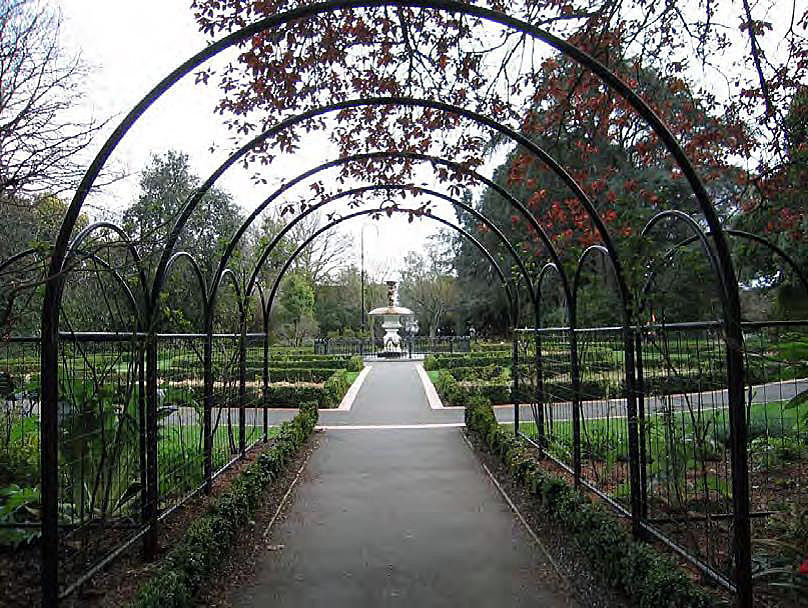
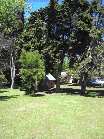
Approaching Albion Square from the main entrance on the Hardy Street side one encounters the former Hardy Street Girls School (1860) and the Pillar Letter Box (1862). Immediately to the east of these structures starts is a concrete driveway that leads into Albion Square. The eastern elevation of the former school can be seen as one walks along the driveway, and a survey test mark (1902) can be viewed in the fourth car park on this side of the former school. Immediately to the east of the driveway is a line of trees and beyond that the Trout hatchery and pathway. Immediately to the north of the former school is the former Caretaker or custodians house (c1860). To the west of this house is the modern Police Station (1961). Approaching Albion Square from the pathway on Hardy Street one is greeted by park like settings. Moving northwards along the path the Trout Hatchery (1867) is to the east. Eight large trees and a large lawn surround the area immediately to the west of the hatchery, beyond this, further to the west, are the school and other structures described above. Immediately to the North of the hatchery are bicycle sheds (1939-1950) and further to the east of the hatchery is the former Nelson Technical School (1905). Moving further northwards down the path and rejoining the driveway from Hardy Street there are a number of car parks. These are near to the Fire Engine House (1866) which abuts the more recent addition of the former Ministry of Works workshops and garages (1936, additions 1962). The fire engine house is somewhat obscured by a small tree in front and by the shadows of large trees. The back of the workshop also blocks access to the eastern elevation of the fire engine house. At the time of the site visit there was organic rubbish in a bin immediately beside the northern elevation of the fire engine house. The Brick Magazine (1861) immediately to the north of the fire engine house is better sheltered from more modern additions to the area. The car parking to the south of the Brick Magazine can be viewed but the structure is largely surrounded by lawn and trees. A row of trees separates the Brick Magazine from the Bishop Suter Memorial Art Gallery (1899) and from the Queens Gardens (1891); a pathway connects all three. Further trees separate the Brick Magazine from the main area of car parking towards the north. If facing west at this point most of the modern buildings within Albion Square can be viewed. Most, bar the former Ministry of Works workshops and garages, are some distance away. These modern buildings detract less from the area than the concrete driveways and car parking that exists throughout that all too often closely abuts the significant elements of the historic area. The presence of the trees add significantly the historic area screening significant elements from car parking and modern buildings in the area. The survey test marks located alongside Bridge Street (1877) are somewhat isolated from the other features of the historic area. The marks are found some distance to the north of the Brick Magazine, beyond the main area of car parking. They are on the perimeter of Albion Square next to Bridge Street but set up from the road, approximately 4.5 metres from the inside edge of the Bridge Street footpath and approximately 14 metres from the boundary of The Suter Te Aratoi o Whakatu. To the east of the marks is a plaque that was erected by NZHPT that tells of the purpose of the marks. Approaching Albion Square from the main Bridge Street entrance one encounters car parking and the modern additions to the area, including the Courthouse (1974) to the south and the Munro Buildings (1966) to the west. Though notable trees line the entrance to the east, and the survey test marks are found here, the significant elements of the historic area are not immediately visible from this entrance.
Approaching Albion Square from the main entrance on the Hardy Street side one encounters the former Hardy Street Girls School (1860) and the Pillar Letter Box (1862). Immediately to the east of these structures starts is a concrete driveway that leads into Albion Square. The eastern elevation of the former school can be seen as one walks along the driveway, and a survey test mark (1902) can be viewed in the fourth car park on this side of the former school. Immediately to the east of the driveway is a line of trees and beyond that the Trout hatchery and pathway. Immediately to the north of the former school is the former Caretaker or custodians house (c1860). To the west of this house is the modern Police Station (1961). Approaching Albion Square from the pathway on Hardy Street one is greeted by park like settings. Moving northwards along the path the Trout Hatchery (1867) is to the east. Eight large trees and a large lawn surround the area immediately to the west of the hatchery, beyond this, further to the west, are the school and other structures described above. Immediately to the North of the hatchery are bicycle sheds (1939-1950) and further to the east of the hatchery is the former Nelson Technical School (1905). Moving further northwards down the path and rejoining the driveway from Hardy Street there are a number of car parks. These are near to the Fire Engine House (1866) which abuts the more recent addition of the former Ministry of Works workshops and garages (1936, additions 1962). The fire engine house is somewhat obscured by a small tree in front and by the shadows of large trees. The back of the workshop also blocks access to the eastern elevation of the fire engine house. At the time of the site visit there was organic rubbish in a bin immediately beside the northern elevation of the fire engine house. The Brick Magazine (1861) immediately to the north of the fire engine house is better sheltered from more modern additions to the area. The car parking to the south of the Brick Magazine can be viewed but the structure is largely surrounded by lawn and trees. A row of trees separates the Brick Magazine from the Bishop Suter Memorial Art Gallery (1899) and from the Queens Gardens (1891); a pathway connects all three. Further trees separate the Brick Magazine from the main area of car parking towards the north. If facing west at this point most of the modern buildings within Albion Square can be viewed. Most, bar the former Ministry of Works workshops and garages, are some distance away. These modern buildings detract less from the area than the concrete driveways and car parking that exists throughout that all too often closely abuts the significant elements of the historic area. The presence of the trees add significantly the historic area screening significant elements from car parking and modern buildings in the area. The survey test marks located alongside Bridge Street (1877) are somewhat isolated from the other features of the historic area. The marks are found some distance to the north of the Brick Magazine, beyond the main area of car parking. They are on the perimeter of Albion Square next to Bridge Street but set up from the road, approximately 4.5 metres from the inside edge of the Bridge Street footpath and approximately 14 metres from the boundary of The Suter Te Aratoi o Whakatu. To the east of the marks is a plaque that was erected by NZHPT that tells of the purpose of the marks. Approaching Albion Square from the main Bridge Street entrance one encounters car parking and the modern additions to the area, including the Courthouse (1974) to the south and the Munro Buildings (1966) to the west. Though notable trees line the entrance to the east, and the survey test marks are found here, the significant elements of the historic area are not immediately visible from this entrance.
Historical and Associated Iwi / Hapū / Whānau
Completion Date
5th June 2007
Report Written By
Imelda Bargas and Rebecca O'Brien
Information Sources
Bagley, 1997
Steve Bagley, Historic Values of the Workshop Complex Buildings - Albion Square Historic Reserve, and Recommendations for their future, 26 May 1997.
Bowman, 1991
Ian Bowman, Albion Square Conservation Assessment, Works Consultancy Services, January 1991.
Brinkman, 2005
Ellen Brinkman, A Study of the Queens Gardens; Nelson's Heritage, 2005.
Brown, 1980
M Brown, 'Albion Square', Nelson Historical Society Journal, November 1980, vol.3, no.6, pp.4-10
McAloon, 1997
Jim McAloon, Nelson: A Regional History, Whatamango Bay, 1997
Mitchell, 2004
J and H Mitchell, Te Tau Ihu o te Waka - A History of Maori of Marlborough and Nelson, Wellington, 2004
Colonist
The Colonist
Ministry of Works and Development
Ministry of Works and Development
Other Information
A fully referenced version of the registration report is available from the NZHPT Central Regional Office. Please note that entry on the New Zealand Heritage List/Rarangi Korero identifies only the heritage values of the property concerned, and should not be construed as advice on the state of the property, or as a comment of its soundness or safety, including in regard to earthquake risk, safety in the event of fire, or insanitary conditions.
Current Usages
Uses: Civic Facilities
Specific Usage: Historic or recreation reserve
Uses: Civic Facilities
Specific Usage: Square - public
Uses: Civic Facilities
Specific Usage: Tree/tree groups
Uses: Communication
Specific Usage: Post Box
Uses: Education
Specific Usage: Polytechnic
Uses: Exploration
Specific Usage: Chain mark
Uses: Government
Specific Usage: Government - other
Uses: Law Enforcement
Specific Usage: Courthouse
Uses: Trade
Specific Usage: Office building/Offices
Former Usages
General Usage: Civic Facilities
Specific Usage: Residential Buildings - other
General Usage: Civic Facilities
Specific Usage: Square - public
General Usage: Civic Facilities
Specific Usage: Tree/tree groups
General Usage: Communication
Specific Usage: Post Box
General Usage: Education
Specific Usage: School
General Usage: Exploration
Specific Usage: Chain mark
General Usage: Funerary Sites
Specific Usage: Morgue/mortuary
General Usage: Utilities
Specific Usage: Fire Station
Themes
Of Significance to Maori
Location
Related listings
Sign up to hear more
Get the latest heritage news, features and events delivered
straight to your inbox.
