

The Tauranga Bridge gave access from the main Waioeka thoroughfare to a side branch extending up the Tauranga Valley. Farmed by several settler families, this area had been divided into mostly 607-hectare (1500-acre) sections by the Crown and offered by ballot in 1906. The Crown had obtained the land in the late 1800s, with previous Maori cultivation alongside the Waioeka River encompassing a settlement at Waipuna Pa, adjacent to the bridge site. Struggling with difficult conditions from an early stage, the settlers' problems were compounded in 1918, when a flood swept away the first suspension bridge across the river. As a temporary measure, a traverse was created using a cage suspended on a wire, described at the time as 'a brute of a crossing'. Its replacement was initially intended to be a stock bridge, but was modified following the intervention of the mayor of Opotiki, George Moody (c.1872-1967), who had purchased land in the valley in 1919. Moody persuaded the local authorities to create a structure large enough for vehicles, enabling him to remove timber from the area more freely.
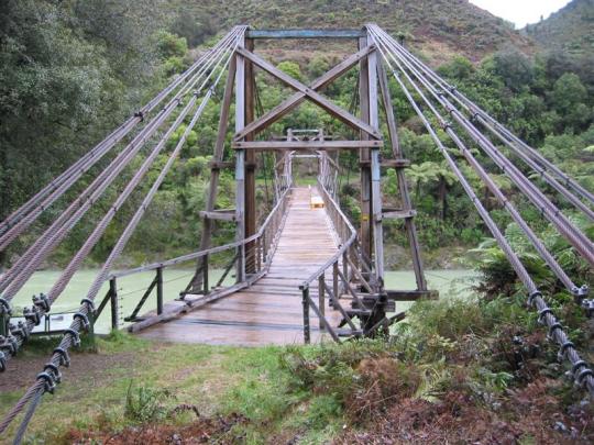
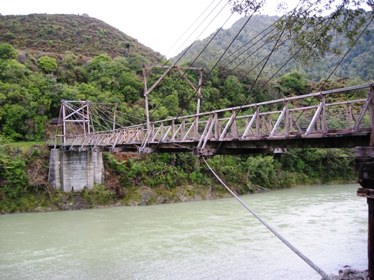
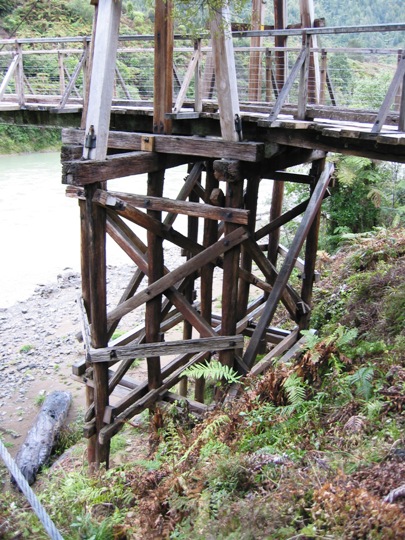
Probably constructed after June 1922 for Opotiki County Council, the bridge was designed by the Public Works Department (PWD). It had a single span of 57.8 metres between two gantry-like towers, from which six metal cables on each side were suspended. The timber superstructure was built exclusively of hardwood, imported from Australia. Multiple rope suspension bridges were first used in New Zealand in 1878, and were an adaptation of British designs utilising American cable wire technology. Widely employed until about 1930, this technology was probably also used for a number of smaller bridges in the immediate vicinity, including the Tauranga Stream and Oponae Stock Bridges, which were designed by the PWD in 1914. The Tauranga Bridge was erected by Percy Kerr, who carried out other road-building tasks in the Waioeka. Following the abandonment of farms serviced by the bridge in the late 1920s and the dwindling use of nearby properties in subsequent years, the structure gradually fell into disrepair. It was the subject of major conservation work by the Department of Conservation in the mid 1990s, allowing access to the Tauranga walking track as part of the Waioeka Gorge Scenic Reserve.
Tauranga Bridge is nationally significant as one of possibly three remaining multiple rope suspension bridges in New Zealand, and the only survivor designed for vehicle access. It reflects a tradition of adapting overseas technology and design for use in New Zealand. The bridge is closely linked with farming and environmental history in the Eastern Bay of Plenty, and is particularly associated with government settlement policies in the early 1900s and their ultimate failure in the Waioeka. The bridge is considered to have strong aesthetic qualities, based on its well-balanced design and its location in an attractive reach of the Waioeka River. It is part of a broader historic and cultural landscape that incorporates Waipuna pa, remnants of roads and other features in the Tauranga Valley. It is one of at least two recognised historic bridges in the Waioeka Valley.
List Entry Information
Status
Listed
List Entry Status
Historic Place Category 1
Access
Able to Visit
List Number
7221
Date Entered
3rd March 1995
Date of Effect
3rd March 1995
City/District Council
Ōpōtiki District
Region
Bay of Plenty Region
Legal description
Sec 1 SO 8858 (NZ Gazette 1999, p.1253), Waioeka River, and Road Reserve Waioeka Road, Gisborne Land District
Why is this place significant?
Historic Significance
Historical Significance or Value This historic place was registered under the Historic Places Act 1993. The following text is from the original Recommendation for Registration considered by the NZHPT Board at the time of registration. Tauranga Bridge is a place associated with the rehabilitation of returned servicemen from the First World War, and is a memorial to their efforts to improve their situation.
Physical Significance
This historic place was registered under the Historic Places Act 1993. The following text is from the original Recommendation for Registration considered by the NZHPT Board at the time of registration. Aesthetic: Tauranga Bridge occupies and enhances an attractive reach of the Waioeka River. The multi-rope system of the bridge evenly supports the structure with a balanced design displaying aesthetic qualities. Architectural: The bridge demonstrates the development of New Zealand suspension bridge technology in the period c.1878-1930, and represents a local application of overseas wire rope construction technology. Technological: The use in New Zealand of the overseas technique of wire cable suspension was an innovation which proved to be both aesthetically pleasing in design and extremely durable in construction.
Why is this place Category 1 / Category 2?
Detail Of Assessed Criteria
This historic place was registered under the Historic Places Act 1993. The following text is from the original Recommendation for Registration considered by the NZHPT Board at the time of registration. (g) The technical accomplishment or value, or design of the place: The Tauranga Bridge is a single span multi rope type suspension bridge, commonly referred to as an "harp" suspension bridge. It was designed in 1916-18 and built around 1921, according to local oral sources. Prior to the use of the wire rope cable technique, bridges in New Zealand were of English wrought iron multi-rod construction. The wire rope cable technique had been in use for a relatively short time in France and America before first being used in New Zealand in the Kawarau Bridge in 1878-80. This technique proved to be both aesthetically pleasing and technologically durable in construction. In Tauranga Bridge, the Public Works engineers adapted the use of steel rope to the English multi-rod system, which reveals a high degree of innovation by New Zealand engineers using an American initiative in the development of steel rope suspension bridge construction. (j) The importance of identifying rare types of historic places: Although once apparently common, the number of surviving multi-rope bridges in new Zealand is very small. Tauranga Bridge's rarity is further enhanced by its technological interest, being a New Zealand adaptation of an English design, using American techniques and innovations. Conclusion: Tauranga Bridge, Bay of Plenty, is recommended for registration as a Category I historic place as a place of special and outstanding historical and cultural heritage significance and value. Its shows great technological significance, being a New Zealand adaptation of an English design, using American techniques and innovations. This technique of using wire rope cables proved to be both aesthetically pleasing and technologically durable in construction.
Construction Professional
Name
Public Works Department
Type
Architect
Biography
No biography is currently available for this construction professional
Name
Public Works Department
Type
Architect
Biography
No biography is currently available for this construction professional
Name
Kerr, Percy
Type
Builder
Biography
No biography is currently available for this construction professional
Construction Details
Type
Other
Description
Site of Waipuna Pa
Period
pre-1904
Start Year
1906
startYearCirca
Type
Other
Description
Construction of first bridge, destroyed by flood in 1918
Start Year
1918
Type
Other
Description
Temporary crossing
Start Year
1922
startYearCirca
Finish Year
1924
finishYearCirca
Type
Original Construction
Description
Construction of current bridge
Start Year
1994
Finish Year
1996
Type
Modification
Description
Major repairs to bridge superstructure
Historical and Associated Iwi / Hapū / Whānau
Completion Date
27th June 2007
Report Written By
Martin Jones and Shirley Arabin
Information Sources
Appendices to the Journals of the House of Representatives (AJHR)
Appendices to the Journals of the House of Representatives
Department of Conservation
Department of Conservation
Spencer, 1992
Margaret Spencer, The Waioeka Pioneering Saga, Gisborne, 1992
Thornton, 2001
Geoffrey Thornton, Bridging the Gap, Early Bridges in New Zealand 1830-1939, Auckland, 2001
Frampton, 1985
K Frampton, Modern Architecture, a Critical History. Thames & Hudson, London, 1985
Conservation Plan
Conservation Plan
National Geographic
National Geographic
Other Information
A copy of the original report is available from the NZHPT Northern region office Please note that entry on the New Zealand Heritage List/Rarangi Korero identifies only the heritage values of the property concerned, and should not be construed as advice on the state of the property, or as a comment of its soundness or safety, including in regard to earthquake risk, safety in the event of fire, or insanitary conditions.
Current Usages
Uses: Transport
Specific Usage: Bridge/ Viaduct
Former Usages
General Usage: Transport
Specific Usage: Bridge/ Viaduct
Web Links
description: Engineering NZ Heritage
Current Usages
Uses: Transport
Specific Usage: Bridge/ Viaduct
Former Usages
General Usage: Transport
Specific Usage: Bridge/ Viaduct
Web Links
description: Engineering NZ Heritage
Location
Sign up to hear more
Get the latest heritage news, features and events delivered
straight to your inbox.
