

List Entry Information
Status
Listed
List Entry Status
Historic Place Category 1
Access
Able to Visit
List Number
7396
Date Entered
27th June 1997
Date of Effect
27th June 1997
City/District Council
Wellington City
Region
Wellington Region
Extent of List Entry
The Registration includes the unsealed section of Old Coach Road, which extends from the intersection between Old Coach Road and Rifle Range Road in Ohariu Valley, to the end of the unsealed intersection between the unsealed portion of Old Coach Road and Broderick Road in Johnsonville.
Legal description
Part of Road shown on SO 19727, SO 36894, 37205, Wellington Land District
Location Description
Unsealed road from Rifle Range Road in Ohariu Valley to Broderick Road, Johnsonville.
Why is this place significant?
Historic Significance
Historical Significance or Value Old Coach Road was constructed between 1856 and 1858 and for a brief time provided the main access route between Ohariu Valley and Johnsonville. The name is a misnomer, since it was not a true coach road, but it remained in use for vehicular traffic until at least the end of the 19th century and has since been used by pedestrians. Although its historical significance is modest, its survival in largely unmodified form so close to an urban centre makes it rare.
Physical Significance
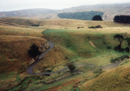
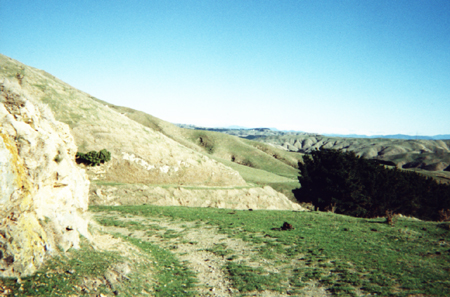
The Old Coach Road at Johnsonville was constructed according to mid nineteenth century road engineering techniques which required constant grades of between 1 in 12 to 1 in 15 for horse drawn traffic. Standard design indicators visible on Old Coach Road are; - Metalled surface on filled, dirt bed - Bench cut profile with hard outside edge on hill slope - A winding course in order to maintain an even grade over an extended distance - Culverts to provide for water courses under the road
Why is this place Category 1 / Category 2?
Detail Of Assessed Criteria
s23(2)(g) The technical accomplishment or value, or design of the place: The Old Coach Road at Johnsonville has distinctive technological, engineering and design values. The design of the road was such that it followed the contours of the hills between Ohariu and Johnsonville in order to maintain a steady rather than a sudden gradient that non-motorised transport could cope with. Some distinctive engineering features have been covered over or lost, such as the original metalled surface, but it is still possible to see the original profile of the road in the bench-cut formation cut into the side of the hills that the road runs over. The original design and construction of this road is in fact remarkably intact after 140 years, and has had only minimal modifications within this time-span, making the place special and outstanding from a civil engineering design point of view. Gavin McLean has pointed out that the history of roading in New Zealand is a virtually unrecorded topic. In this sense it would be desirable to extend the national register by including within it representative examples of early roading in New Zealand, particularly in view of Michael Kelly's comment "The pool of relatively original 'horse era' roads in New Zealand is very small and is confined to remote or rural areas, largely in the South Island". The Old Coach Road, Johnsonville, deserves recognition not only because of the relative rarity of such roads, but because in this case it proves to be an exception by being located close to a large urban area in the North Island. It is also special and outstanding because, comparatively speaking, it has remained relatively unaltered while still remaining in use up to the present day. s23(2)(j) The importance of identifying rare types of historic places: Michael Kelly considers that 'the pool of relatively original 'horse era' roads in New Zealand is relatively small and is confined to remote or rural areas, largely in the South Island. While plenty of roads in this country follow their original routes none have remained relatively unaltered to this [Old Coach Road] extent while still in use; in fact no other road in New Zealand can make this claim.
Why is this place significant?
Historic Significance
Historical Significance or Value Old Coach Road was constructed between 1856 and 1858 and for a brief time provided the main access route between Ohariu Valley and Johnsonville. The name is a misnomer, since it was not a true coach road, but it remained in use for vehicular traffic until at least the end of the 19th century and has since been used by pedestrians. Although its historical significance is modest, its survival in largely unmodified form so close to an urban centre makes it rare.
Physical Significance
The Old Coach Road at Johnsonville was constructed according to mid nineteenth century road engineering techniques which required constant grades of between 1 in 12 to 1 in 15 for horse drawn traffic. Standard design indicators visible on Old Coach Road are; - Metalled surface on filled, dirt bed - Bench cut profile with hard outside edge on hill slope - A winding course in order to maintain an even grade over an extended distance - Culverts to provide for water courses under the road
Why is this place Category 1 / Category 2?
Detail Of Assessed Criteria
s23(2)(g) The technical accomplishment or value, or design of the place: The Old Coach Road at Johnsonville has distinctive technological, engineering and design values. The design of the road was such that it followed the contours of the hills between Ohariu and Johnsonville in order to maintain a steady rather than a sudden gradient that non-motorised transport could cope with. Some distinctive engineering features have been covered over or lost, such as the original metalled surface, but it is still possible to see the original profile of the road in the bench-cut formation cut into the side of the hills that the road runs over. The original design and construction of this road is in fact remarkably intact after 140 years, and has had only minimal modifications within this time-span, making the place special and outstanding from a civil engineering design point of view. Gavin McLean has pointed out that the history of roading in New Zealand is a virtually unrecorded topic. In this sense it would be desirable to extend the national register by including within it representative examples of early roading in New Zealand, particularly in view of Michael Kelly's comment "The pool of relatively original 'horse era' roads in New Zealand is very small and is confined to remote or rural areas, largely in the South Island". The Old Coach Road, Johnsonville, deserves recognition not only because of the relative rarity of such roads, but because in this case it proves to be an exception by being located close to a large urban area in the North Island. It is also special and outstanding because, comparatively speaking, it has remained relatively unaltered while still remaining in use up to the present day. s23(2)(j) The importance of identifying rare types of historic places: Michael Kelly considers that 'the pool of relatively original 'horse era' roads in New Zealand is relatively small and is confined to remote or rural areas, largely in the South Island. While plenty of roads in this country follow their original routes none have remained relatively unaltered to this [Old Coach Road] extent while still in use; in fact no other road in New Zealand can make this claim.
Construction Details
Start Year
1856
Finish Year
1859
Type
Original Construction
Type
Modification
Description
Various sections of the road widened
Period
pre-1945
Start Year
1945
Type
Modification
Description
Small section converted to modern road to service new housing
Start Year
1963
Type
Modification
Description
Four wheel side-tracks created by bull-dozers
Start Year
1963
Type
Other
Description
Culverts and bridge repaired
Start Year
1980
startYearCirca
Finish Year
1988
finishYearCirca
Type
Addition
Description
Two concrete culverts installed
Start Year
1992
Type
Modification
Description
Road widened and metalled for short sections at Johnsonville end
Start Year
1992
Type
Modification
Description
Developers dump fill on 250 metres of road
Start Year
1992
Type
Modification
Description
Small drain and culvert installed near fill
Construction Materials
The road originally consisted of a metalled surface on a filled dirt bed.
Built between 1856 and 1859 to encourage settlement of the isolated Ohariu Valley, the misnamed Old Coach Road is a rare example of an intact, original nineteenth-century public works thoroughfare. When the New Zealand Company sold the valley sections in 1841 the track used by local Maori was converted into a short, rudimentary road to cater for the new settlers. Despite this, few new owners chose to occupy their land and in 1854 only three pakeha settlers were living in the area. In 1858 the first superintendent of the Wellington Province, Dr. Isaac Featherston [1813-1876], suggested the reason the district had remained 'a waste and unoccupied for seventeen years' was the lack of adequate access to the valley. Granted the power to provide roads under the 1854 Roads Act, the Wellington Provincial Council advertised in the Wellington Gazette in 1856 for labourers to build a road between Ohariu Valley and the nearby Johnsonville settlement. Work began on what is now known as 'Old Coach Road' in late 1856. Labourers working on the road complained about the bleak conditions and poor pay and in 1857 the road was still unfinished. The Council set aside £1500 for the road and passed the Ohariu and Makara Roads Act, enabling them to levy rates on owners of land served by the road. The settlers did not support this move and many refused to pay the rates. In 1858 the council decided to extend the road, which had reached Ohariu Valley earlier that year, to increase the benefits for more rated owners. The tender was won by Lewis Brown and Frederick Darby and the road, then known as 'Ohariu Road', was finally completed in 1859. The improved access to the valley encouraged settlement and the population of the area increased. As the road had been designed primarily for the bullock teams used to haul logs from the valley to the mill at Johnsonville, the gradient was too steep for use by horse teams or coaches . In 1863 the lack of coach access prompted the Council to provide another road to the valley. Built between 1864 and 1866, 'Ohariu Road No.2' was constructed on a more gradual gradient and on a lower elevation than the earlier road. As a consequence, the new road soon became the main access route to the valley. Old Coach Road became known as Ohariu Road No.1. It continued to be used by local farmers but lower usage of the road prompted the Johnsonville Town Board to propose its closure in 1897. No action was taken and it continued to be maintained as a legal road. Paradoxically, during the mid-twentieth century the road was identified by the misnomer 'Coach Road' or 'Old Coach Road'. Due to its use for access to new housing divisions on the Johnsonville end of the road in 1945 and 1971, some sections of the road have been sealed. Other areas of the road were modified in preparation for use of the road for public works developments in 1963. In 1992 developers widened short sections of the road and 250 metres of it were covered with fill. The scale of the changes proposed by developers encouraged the Johnsonville Residents Association to seek official recognition and protection for the historic road. Protection for the full length of the road was gained in 2001 and Old Coach Road, now used primarily for recreational pursuits, remains one of New Zealand's best examples of an original nineteenth-century public works thoroughfare.
Built between 1856 and 1859 to encourage settlement of the isolated Ohariu Valley, the misnamed Old Coach Road is a rare example of an intact, original nineteenth-century public works thoroughfare. When the New Zealand Company sold the valley sections in 1841 the track used by local Maori was converted into a short, rudimentary road to cater for the new settlers. Despite this, few new owners chose to occupy their land and in 1854 only three pakeha settlers were living in the area. In 1858 the first superintendent of the Wellington Province, Dr. Isaac Featherston [1813-1876], suggested the reason the district had remained 'a waste and unoccupied for seventeen years' was the lack of adequate access to the valley. Granted the power to provide roads under the 1854 Roads Act, the Wellington Provincial Council advertised in the Wellington Gazette in 1856 for labourers to build a road between Ohariu Valley and the nearby Johnsonville settlement. Work began on what is now known as 'Old Coach Road' in late 1856. Labourers working on the road complained about the bleak conditions and poor pay and in 1857 the road was still unfinished. The Council set aside £1500 for the road and passed the Ohariu and Makara Roads Act, enabling them to levy rates on owners of land served by the road. The settlers did not support this move and many refused to pay the rates. In 1858 the council decided to extend the road, which had reached Ohariu Valley earlier that year, to increase the benefits for more rated owners. The tender was won by Lewis Brown and Frederick Darby and the road, then known as 'Ohariu Road', was finally completed in 1859. The improved access to the valley encouraged settlement and the population of the area increased. As the road had been designed primarily for the bullock teams used to haul logs from the valley to the mill at Johnsonville, the gradient was too steep for use by horse teams or coaches . In 1863 the lack of coach access prompted the Council to provide another road to the valley. Built between 1864 and 1866, 'Ohariu Road No.2' was constructed on a more gradual gradient and on a lower elevation than the earlier road. As a consequence, the new road soon became the main access route to the valley. Old Coach Road became known as Ohariu Road No.1. It continued to be used by local farmers but lower usage of the road prompted the Johnsonville Town Board to propose its closure in 1897. No action was taken and it continued to be maintained as a legal road. Paradoxically, during the mid-twentieth century the road was identified by the misnomer 'Coach Road' or 'Old Coach Road'. Due to its use for access to new housing divisions on the Johnsonville end of the road in 1945 and 1971, some sections of the road have been sealed. Other areas of the road were modified in preparation for use of the road for public works developments in 1963. In 1992 developers widened short sections of the road and 250 metres of it were covered with fill. The scale of the changes proposed by developers encouraged the Johnsonville Residents Association to seek official recognition and protection for the historic road. Protection for the full length of the road was gained in 2001 and Old Coach Road, now used primarily for recreational pursuits, remains one of New Zealand's best examples of an original nineteenth-century public works thoroughfare.
The hillsides between the two settlements were cleared of bush and then cut away to create a flat ridge that formed the basis of the road. This 'bench cut' construction technique involved the removal of large amounts of clay and rock. On some slopes this fill may have been used to build up the outside edge of the road but, as a hard outside edge was considered preferable, the full width bench of 4.2 metres was generally cut into the base rock. Some of the greywacke removed from the hillside may have been used to metal the road. Close to the bottom of the hill, near the Ohariu Valley, two culverts were constructed where the three-kilometre road passed over watercourses. In accordance with the normal building practices of the period, the road was built on the easy and constant gradient of between 1 in 12 and 1 in 15 that was required by non-motorised transport. The winding character of the road is a reflection of the need to maintain this constant grade. Part of the original road has since been sealed due to the development of new housing divisions on the Johnsonville end of the road in 1945 and 1971 (please note that sealed portions of the original road are not included in this registration). Other areas of the road have been modified in preparation for use of the road for public works developments in 1963 and in 1992 developers widened short sections of the road and 250 metres of it were covered with fill.
The hillsides between the two settlements were cleared of bush and then cut away to create a flat ridge that formed the basis of the road. This 'bench cut' construction technique involved the removal of large amounts of clay and rock. On some slopes this fill may have been used to build up the outside edge of the road but, as a hard outside edge was considered preferable, the full width bench of 4.2 metres was generally cut into the base rock. Some of the greywacke removed from the hillside may have been used to metal the road. Close to the bottom of the hill, near the Ohariu Valley, two culverts were constructed where the three-kilometre road passed over watercourses. In accordance with the normal building practices of the period, the road was built on the easy and constant gradient of between 1 in 12 and 1 in 15 that was required by non-motorised transport. The winding character of the road is a reflection of the need to maintain this constant grade. Part of the original road has since been sealed due to the development of new housing divisions on the Johnsonville end of the road in 1945 and 1971 (please note that sealed portions of the original road are not included in this registration). Other areas of the road have been modified in preparation for use of the road for public works developments in 1963 and in 1992 developers widened short sections of the road and 250 metres of it were covered with fill.
Historical and Associated Iwi / Hapū / Whānau
Public NZAA Number
R27/220
Completion Date
11th February 2005
Report Written By
Rebecca O'Brien / NZHPT
Information Sources
Bremner, 1983
J. Bremner, 'Wellington's Northern Suburbs 1849-1918', Wellington, 1983
Ward, 1928
L. Ward, Early Wellington, Wellington, 1928
Conservation Plan
Conservation Plan
Other Information
A fully referenced version of this report is available from the NZHPT Central Region Office Please note that entry on the New Zealand Heritage List/Rarangi Korero identifies only the heritage values of the property concerned, and should not be construed as advice on the state of the property, or as a comment of its soundness or safety, including in regard to earthquake risk, safety in the event of fire, or insanitary conditions.
Current Usages
Uses: Transport
Specific Usage: Road
Former Usages
General Usage: Transport
Specific Usage: Road
Current Usages
Uses: Transport
Specific Usage: Road
Former Usages
General Usage: Transport
Specific Usage: Road
Location
Sign up to hear more
Get the latest heritage news, features and events delivered
straight to your inbox.
