

This historic area was registered under the Historic Places Act 1993. The following text is from the original Historic Area Assessment Under Section 23 Criteria report considered by the NZHPT Board at the time of registration.
DESCRIPTION:
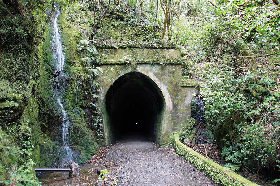
The 16 kilometres of railway formation between State Highway 2 at Kaitoke and the former rail settlement at Cross Creek is now a popular walkway. It includes the historically significant Remutaka Incline. Annually, some 30,000 walkers, runners and mountain bikers use this rail trail.
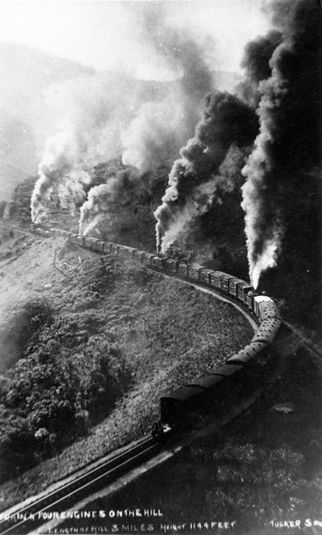
The section of rail formation between the Summit and Cross Creek is known as the Remutaka Incline. It is a 4.8 kilometre stretch of steep mountain railway. Trains travelled the Incline to and from the Wairarapa from 16 October 1878 to 29 October 1955 when rail traffic was re-routed through the new Remutaka tunnel. The railway was twice as steep as the steepest mainline railway in New Zealand. A special 'Fell' system was employed to assist the locomotives grip the rails.
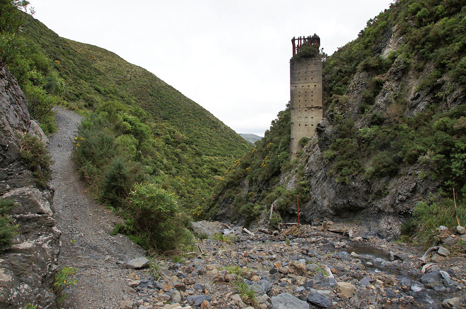
The Incline's formation, which includes embankments, tunnels, culverts and associated structures and occupation sites (Summit yard, Cross Creek and campsites), are archaeological sites as defined in section 2 of the Historic Places Act 1993. Trust authorisation is required for any works that might modify or damage these sites. Artefacts and remnants of railway structures continue to be found in the vicinity of the Incline, and many remain uncovered.
A lengthy part of the route is vested in the Wellington Regional Council which has allowed sections to be used as a logging route - with serious implications for maintenance of the formation. The Department of Conservation manages the area from Cross Creek to the Summit Tunnel under a conservation plan.
List Entry Information
Status
Listed
List Entry Status
Historic Area
Access
Able to Visit
List Number
7511
Date Entered
31st May 2002
Date of Effect
31st May 2002
City/District Council
Upper Hutt City,South Wairarapa District
Region
Wellington Region
Extent of List Entry
Extent of registration is the former rail track indicated on the map in the Registration report and land twenty metres on either side of the track including the structures marked on the map. The route is approximately 16 km in length. It is the mountain division of the former Wellington to Masterton railway. The registered section stretches from the original Kaitoke Station over the Remutaka ranges to the former Cross Creek Station. The route follows the old rail corridor which was initially on Crown land. This stretch is now known as 'the Incline'; the original incline was the steep gradient from Summit Station to Cross Creek which is incorporated into this area. A feature of the railway is the number of culverts and tunnels cut to control flooding on the track
Legal description
Private land on the Wairarapa side of Cross Creek: Sec 119 Blk V, Wairarapa SD, 10.3584, SO 23442, State Forest NZ Gazette 1960, p.973. Cross Creek DOC land up to Summit Tunnel: Sec 116, Western Lake District, 76.3844, SO 23447, State Forest NZ Gazette 1958, p.1415. Wellington Regional Council: Pt Lot DP 47840, 6829.4907, (RT 47C/376), Pakuratahi State Forest. Private land bordering State Highway 2 Pt Sec 29, Pakuratahi District, 14.0294, SO 15791 Lot 1, DP 67970, 1.0000 Lot 2, DP 87891, 0.4890.
Why is this place significant?
Cultural Significance
This historic area was registered under the Historic Places Act 1993. The following text is from the original Historic Area Assessment Under Section 23 Criteria report considered by the NZHPT Board at the time of registration. CULTURAL SIGNIFICANCE: The Remutaka rail route was a government-owned railway to all points north through the Wairarapa. The railway over the Remutakas played a significant part in opening up areas for economic growth. For 77 years, all wool, beef and dairy produce was transported over the Remutaka Incline route. By 1893, 15 years after the opening of the line, the population of the Wairarapa had more than doubled. Construction of the Incline took nearly four years. The terrain and geology posed major difficulties for the technology available at the time, leading to big delays in completion. One head contract finished 20 months behind schedule. Two men were killed working on Price's Tunnel, and one person was killed on the construction of the Summit Tunnel. The Incline is a monument to the commitment of those involved in its construction. Regular locomotives were exchanged for 'Fell' engines for the 4.8 kilometres between Summit and Cross Creek, after which regular engines completed the journey to Featherston northbound or Upper Hutt southbound. All 'Fell' engines were housed and maintained at Cross Creek. Cross Creek Village, the main railway settlement on the line, was built solely for railway workers and their families. In its heyday, up to 120 people lived there. Isolation seemed to intensify community feeling and a sense of belonging to this unique place. What the settlement lacked in amenities was more than compensated for by the spirit of those living there. Summit was a smaller settlement with houses for five families and road access. During the 77 years the railway was opened there was only one fatal accident. At Horseshoe Bend, on 13 September 1880, the two leading passenger carriages were blown off the rails. The timber body work broke up and fell down the embankment into the valley below. Three children were killed and five adults seriously injured. The graves of the children can be seen at the Featherston Cemetery. The Remutaka Railway was seen as of great importance in the nation's development, a perception reinforced by many visiting Royalty who were taken over the route: HRH The Prince of Wales in 1921; the Duke and Duchess of York in 1927; the Duke of Gloucester in 1935; and Her Majesty the Queen and Prince Philip during their visit to New Zealand in 1954.
Historic Significance
Historical Significance or Value This historic area was registered under the Historic Places Act 1993. The following text is from the original Historic Area Assessment Under Section 23 Criteria report considered by the NZHPT Board at the time of registration. HISTORICAL SIGNIFICANCE: The Remutaka Incline and associated railway-related remains are of significant regional and national heritage value. Development of the route was an important part of the history of Wellington and the Wairarapa, and the formation is a rare example of early New Zealand railway engineering. The Wellington to Masterton railway was enabled by Julius Vogel's Railways Act 1870. The line was officially opened on 16 October 1878. The route between the two purpose - built railway settlements at Summit and Cross Creek has a gradient which is particularly steep for any railway, averaging 1 in 15. To handle this, six H class 'Fell' engines were brought out from England, to run solely between the Summit and Cross Creek. The 'Fell' engines used a third rail which worked by adhesion to aid traction up the Incline and to act as a brake coming down. The 'Fell' engine system was patented in 1863 by Englishman John Barraclough Fell and was first used on a 48 mile long railway (the Mont Cenis Railway) over the Alps between France and Italy. This opened in June 1868 and closed in October 1871. The Cantagallo Railway in Brazil also used the 'Fell' system successfully until 1883, when conventional adhesion only locomotives were adapted to work the steep grades encountered on this line. The 'Fell' centre rail was retained on the Cantagallo Railway until the line closed in 1965. The route of the Remutaka Incline was expensive to run and maintain, and was replaced in 1955 by a more direct rail tunnel to the Wairarapa. Houses and other buildings at Summit and at Cross Creek were auctioned, relocated or demolished after 1955, leaving a few remnants of communities that had lived there for nearly 90 years. After the Incline ceased to be used for railway purposes, railway land from Kaitoke to Summit Tunnel was vested in the Wellington City Water Supply Board (now Wellington Regional Council) and from Summit to Cross Creek in the Department of Conservation, formerly the NZ Forest Service. Meetings in 1983 between the Wellington Regional Council and regional environmental and recreation groups led to an agreement for development of a walkway over the route of the former railway, largely in recognition of the heritage values of the area. Since November 1987, the railway formation between State Highway 2 at Kaitoke and the former settlement at Cross Creek has been a popular recreation area for walking and cycling, and has provided access to pylons and forest areas. Some thirty thousand walkers, runners and mountain bikers use the route each year.
Physical Significance
This historic area was registered under the Historic Places Act 1993. The following text is from the original Historic Area Assessment Under Section 23 Criteria report considered by the NZHPT Board at the time of registration. TECHNOLOGICAL: The Remutaka Incline is internationally renowned for its success in utilising 'Fell' engine technology. A railway over the ranges would not have been possible without these engines. The 'Fell' engine incorporated an auxiliary steam engine between its frames. This 'inside' engine drove four wheels which were arranged to grip each side of a large double-headed rail mounted on pedestals in the centre of the track between the two running rails. Four tank locomotives of this type were built for the Remutaka Incline in 1875. Two additional locomotives of a similar type were supplied in 1886. These six locomotives were the mainstay of the Remutaka Incline, although they were supplemented during the early part of the last century by ordinary adhesion locomotives which did not make use of the central rail. A single 'Fell' engine was rated to haul a load of 66 tonnes on the 1 in 15 grade. The maximum goods train load permitted was 264 tonnes for which four locomotives were required spaced along the train so that each hauled its allocated tonnage. Speeds on the Incline were restricted to 10km/hr uphill and 16km/hr down. To control the speed of descending trains, powerful handbrakes were used to bear against the face of the central rail, augmenting the Westinghouse air brakes. An additional safeguard was the use of special "Fell' brake vans. A 254 tonne goods train descending the Incline required five of these vans, each manned by a trained guard. The Remutaka Incline fulfilled its purpose for 77 years, making it the world's longest running 'Fell' railway system. The last 'Fell' engine used on the Incline has been restored and is housed in the Fell Engine Museum in Featherston. The high cost of running and maintaining the 'Fell' engines prompted the creation of new designs for locomotives and although there was one constructed, it was not really a successful adaptation. The 1880 accident at Horseshoe Bend where carriages were blown off the rails with the loss of life prompted improvements in the arrangement of the 'Fell' engines and the erection of windbreaks at Horseshoe Bend (1880) and Pigeon Bush (1888). The first concrete blocks manufactured on site in New Zealand were used for lining the Pakuratahi Tunnel. They were made of pressed cement and sand. It was claimed that these could be made faster and were harder than conventional concrete blocks. This type of block had not been used before in New Zealand as a building material and their use here predated by 27 years the first concrete block houses of the same material. Petrol-driven railcars ('Tin Hares') were built at the Woburn Workshops and put into service in 1936. The railcar was designed especially for the Wairarapa line - to be fast on the flat and also capable of handling the Incline. Railcars climbed the Incline faster than the trains.
Historical and Associated Iwi / Hapū / Whānau
Completion Date
10th March 2003
Report Written By
Helen McCracken
Information Sources
Cameron, 1992
W. N. Cameron, Rimutaka Railway, New Zealand Railway & Locomotive Society, 1992
Other Information
A copy of the original report is available from the NZHPT Central region office Please note that entry on the New Zealand Heritage List/Rarangi Korero identifies only the heritage values of the property concerned, and should not be construed as advice on the state of the property, or as a comment of its soundness or safety, including in regard to earthquake risk, safety in the event of fire, or insanitary conditions. This Historic Area was registered under the Historic Places Act 1993. The following text is from the Board Minutes 3 May 2002 Proposal for registration considered by the NZHPT Board at the time of registration.
Current Usages
Uses: Civic Facilities
Specific Usage: Historic or recreation reserve
Former Usages
General Usage: Transport
Specific Usage: Bridge/ Viaduct
General Usage: Transport
Specific Usage: Railway
General Usage: Transport
Specific Usage: Tunnel
Web Links
description: Engineering NZ Heritage
url: https://www.engineeringnz.org/programmes/heritage/heritage-records/rimutaka-railway/
Location
Sign up to hear more
Get the latest heritage news, features and events delivered
straight to your inbox.
