

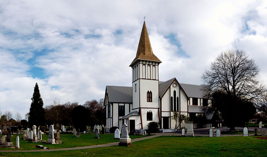
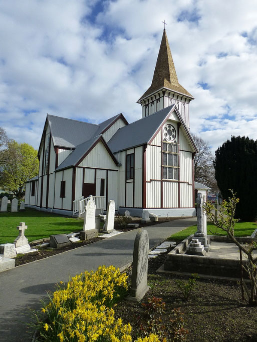
St Paul's Anglican Church (1877), replaced an earlier church built on the site in 1852-3 to serve the settlers who clustered around the stand of bush in the Papanui area, now a suburb of Christchurch. It illustrates the objective of the founding body, the Canterbury Association, that the Anglican Church would be of prime importance in the new Canterbury province. The first burial in St Paul's Churchyard was in 1853 and, by the time the present Church was built in 1877, the Churchyard area was extensive. Planned by New Zealand's most distinguished Gothic Revival architect Benjamin Mountfort (1825-1898), St Paul's Church is an excellent example of his skills in church design. The building has served the parish well over the years, with only minor changes being made. Although more recent subsidiary buildings have been added nearby on the property, the church still stands separately within its spacious churchyard setting. The Church was a key feature in the original village of Papanui and its prominent position continues as a dominating historic element in the heart of the present day suburb. For over 150 years St Paul's has played an important role in the lives of the individual parishioners and the wider community.
Location
List Entry Information
Overview
Detailed List Entry
Status
Listed
List Entry Status
Historic Place Category 2
Access
Private/No Public Access
List Number
7635
Date Entered
12th December 2005
Date of Effect
12th December 2005
City/District Council
Christchurch City
Region
Canterbury Region
Extent of List Entry
Registration includes the Church, its fixtures and fittings, the Churchyard including the land on Part Reserve 64 as shown on Certificate of Title CB392/58; and on part of Lot 9 DP 16730 (RT 22620) Canterbury Land Registration District (excluding the subsidiary buildings).
Legal description
Lot 9 DP 16730 (RT CB392/58) and Pt Res 64 (RT 22620, Canterbury Land District
Cultural Significance
The Church has social significance related to the important role the Anglican church, as a religious institution, has played in the lives of individual parishioners and the wider community for over 150 years. The spiritual values are those of all places of worship, enhanced in this case by the accompanying churchyard and associated war memorial.
Historic Significance
Historical Significance or Value The Church's historic values lie with its foundation at the beginning of Papanui's settlement and it location in the heart of the evolving village. Papanui was a very early focus of settlement when the Canterbury Association's first immigrants came to Christchurch and land was allotted at the beginning of 1851. The original St Paul's Church (1852) was a dominating community facility in the developing Papanui village and the present Church (1877) continues the role of its predecessor in the heart of the present suburb. The construction of the Church illustrates the Canterbury Association's objective for the provision of Anglican places of worship in the new province.
Physical Significance
Designed by New Zealand's pre-eminent Gothic Revival architect, Benjamin Mountfort (1825-1898), St Paul's Church has architectural importance as an example of his ability to design churches which followed the Gothic Revival idiom yet expressed an individual character. St Paul's was planned as a large "village" church with strong verticality combined with simple robust detailing. In its plan and form it illustrates the 19th century principles for Anglican Church design. It has aesthetic value as a fine Gothic Revival structure distinctively set within the well-kept churchyard which features a range of mature English trees, shrubs and garden plots.
Detail Of Assessed Criteria
(a) The extent to which the place reflects important or representative aspects of New Zealand history: At the beginning of Canterbury's settlement land was quickly taken up at Papanui, the location of a stand of bush containing millable timber handy to Christchurch. By 1852 the first St Paul's Church had been built here to serve the rapidly established village. Its construction demonstrates the goal set by the founding fathers for prompt provision of Anglican places of worship. The present Church (1877) continues the role of the earlier structure and has been a centre of worship for over 150 years. (b) The association of the place with events, persons, or ideas of importance in New Zealand history: The Church has been associated with many of Canterbury's most notable pioneering settlers and prominent later citizens, like Robert Heaton Rhodes and William Guise Brittan. Victoria Cross winner, Charles Upham , is one of the many distinguished Cantabrians buried in St Paul's Churchyard. The concept of establishing a churchyard in the grounds surrounding the church is a representation of the English traditions which the Canterbury Association wished to see followed in the new province. Many other churches followed this pattern until public cemeteries were provided. (e) The community association with, or public esteem for, the place: St Paul's Church and Churchyard have a strong visual presence in the centre of the suburb of Papanui and are held in high regard by the general public beyond local residents because of theirs physical and cultural qualities. Since their establishment, the care the St Paul's parish - with community assistance - has given to the Church and the Churchyard environs demonstrates the community's esteem for the place. (f) The potential of the place for public education: The public can learn the history of the Church and its site from an information board located close to the footpath. The parish opens the doors to welcomes visitors one morning each week or by arrangement and this allows for the full history to be discovered, not only of the Church but also of the district it serves. Much can also be learned of Papanui's past by reading the headstones in the churchyard which often detail the sometimes tragic lives of those buried there. (g) The technical accomplishment or value, or design of the place: As an example of Benjamin Mountfort's church design, St Paul's Church is a notable building which has significant heritage value. It has the special qualities of proportion, form and detailing associated with this talented architect working in the middle period of his four decades as the Anglican Diocesan Architect in Canterbury. It is an example of his skills in the Gothic Revival style and in following the accepted nineteenth century principles of the Ecclesiologists for the planning and form of Anglican churches. St Paul's Church also demonstrates Mountfort's abilities to translate into timber the Gothic forms usually constructed in stone. (h) The symbolic or commemorative value of the place: The Church itself and elements within it commemorate many of the parish's members dating back to the early 1850s. The Churchyard's purpose as a place of burial is strongly complemented by its commemorative role. The Churchyard at St Paul's Church is particularly notable for the number of distinguished former citizens whose lives are recalled by the gravestones here. When the local community decided to erect a memorial to those who served in W.W.I, gates were erected at the entrance to the Church. The gates have since been removed and the commemorative plaque, with the addition of one for W.W. II, was placed on a plinth inside the church grounds.
Construction Professional
Biography
Samuel Jamieson established the Jamieson's building and contracting business in 1864 at Canterbury. His sons James and William were innovative and progressive builders. They were the first in New Zealand, for example, to use steam cranes for lifting heavy masonry during the construction of the Cathedral of the Blessed Sacrament (1901-5). They were also responsible for the Christchurch Press Company building (completed 1909) and Government Buildings, Cathedral Square (1909-13). J and W Jamieson Ltd was acknowledged to be one of the leading building firms in New Zealand in and around the turn of the century.
Name
Jamieson, J & W
Type
Builder
Biography
No biography is currently available for this construction professional
Name
Henshall
Type
Architect
Biography
No biography is currently available for this construction professional
Name
Tomson, C
Type
Builder
Biography
Benjamin Woolfield Mountfort (1825-98) trained as an architect in England, in the office of Richard Cromwell Carpenter, a member of the Cambridge Camden Society (later the Ecclesiological Society). He arrived in Canterbury in 1850. Mountfort was New Zealand's pre-eminent Gothic Revival architect and, according to architectural historian Ian Lochhead, 'did most to shape the architectural character of nineteenth-century Christchurch.' The buildings he designed were almost exclusively in the Gothic Revival style. During his career he designed many churches and additions to churches; those still standing include the Trinity Congregational Church in Christchurch (1874), St Mary's Church in Parnell, Auckland and the Church of the Good Shepherd in Phillipstown, Christchurch (1884). In 1857 he became the first architect to the province of Canterbury. He designed the Canterbury Provincial Council Buildings in three stages from 1858 to 1865. The stone chamber of this building can be considered the greatest accomplishment of his career. He was involved in many important commissions from the 1870s, including the Canterbury Museum (1869-82) and the Clock-tower Block on the Canterbury College campus (1876-77). He was also involved in the construction of Christchurch's Cathedral and made several major modifications to the original design. Mountfort introduced a number of High Victorian elements to New Zealand architecture, such as the use of constructional polychromy, probably first used in New Zealand in the stone tower of the Canterbury Provincial Government Buildings (1859). Overall, his oeuvre reveals a consistent and virtually unerring application of Puginian principles including a commitment to the Gothic style, honest use of materials and picturesque utility. The result was the construction of inventive and impressive buildings of outstanding quality. He died in Christchurch in 1898. A belfry at the Church of the Good Shepherd in Phillipstown, the church he attended for the last ten years of his life, was erected in his honour.
Name
Mountfort, Benjamin Woolfield
Type
Architect
Construction Details
Description
Churchyard; First burial
Start Year
1853
Type
Other
Description
Churchyard; Closed except for use of existing plots
Start Year
1995
Type
Other
Description
Church; Designed
Finish Year
1876
Start Year
1875
Type
Designed
Description
Foundation stone laid by Bishop Harper (2 February).
Start Year
1876
Type
Original Construction
Description
Construction completed
Start Year
1877
Type
Original Construction
Description
Church formally opened (21 December)
Start Year
1877
Type
Other
Description
Consecration of the now debt free Church and set of five bells hung in the tower, after it was strengthened
Start Year
1880
Type
Modification
Description
Installation of stained glass window in sanctuary
Start Year
1885
Type
Modification
Description
Organ installed
Start Year
1906
Type
Other
Description
Original bell tower demolished
Start Year
1910
Type
Demolished - Other
Description
New bell tower built
Start Year
1912
Type
Addition
Description
The Church was lit by electricity
Start Year
1923
Type
Other
Description
Bell tower reinforced, church windows reglazed
Start Year
1926
Type
Modification
Description
Addition of section at west end, replacement of external boards and loss of sections of stringcourse, loss of crosses on apex of gables, glazing of entrance porch
Type
Modification
Description
Shingle roof replaced with decramastic tiles
Start Year
1986
Type
Modification
Construction Materials
Timber construction, decramastic tiled roof replaces the original shingles. Concrete buttresses and internal steel strengthening added to bell tower.
Notable Features
The World War 1 memorial and the head stones in the Churchyard, the pulpit and the stained glass window in the east end of the sanctuary.
St Pauls Church, in what is now the Christchurch suburb of Papanui, is a notable landmark feature because of its Gothic character, prominent location and extensive churchyard surrounds. Papanui village first developed beside the 28 hectare (70 acre) stand of bush in this area. In the 1851 allocation of land, Miss Ann Bowan and William Guise Brittan selected the blocks that included the bush containing Totara, Rimu and kahikatia. The timber available from the two remnants of bush near Christchurch at Papanui and Riccarton was in high demand for building and firewood in the settlement's otherwise treeless vicinity. By the end of the decade the Papanui block, first referred to as the Papanui "Wood", was virtually cleared by pit-sawyers while a section of the Riccarton stand has been retained and conserved. Just a year after the arrival of the Canterbury "pilgrims" in December 1850 there were some 200 residents around the bush, the males being chiefly sawyers. It was the Canterbury Association's intent that the new settlement should be provided with Anglican churches and schools and land was set aside for this purpose. However, it has been suggested by local historians that the land here was donated by William Guise Brittan who then provided pit sawn timber from his section of the bush for the construction of a small, simple "shed" like church. A sketch dated 9th December, 1852 by Dr. A.C. Barker shows the Papanui area with the apparently completed church the focal point in the foreground. Dr. Barker's photographic and sketched records of early Canterbury were meticulously dated. This date could give St Paul's original building (1852) the title of the "first church built on the Canterbury plains", ahead of St Michael and All Angels, which opened 8th January, 1853. The precise date of the first service conducted in St Paul's Church (1852) is not known. The first appointed vicar was Rev. George Dunnage whose ill health prevented him taking up the position. He was the first person buried in the Churchyard in 1853. In 1859 Rev. J. James of England donated ten acres of adjoining land for the church and in 1868 the five acre reserve for church purposes at Papanui was formally designated by a conveyance from the Canterbury Superintendent to the Church Property Trustees. This original 15 acre (6 hectares) church site included what is now St James Park on the other side of the railway line. St Paul's Church served a large parish extending north from Merivale to Marshland and Harewood and from its earliest years many people were buried in its surrounding churchyard. The small basic church originally had a very small capacity and soon required the addition of a chancel and side aisles, enabling it to serve for 25 years. By the 1870s the area extending to Papanui from the city was home to greater numbers, including more prosperous citizens able to provide better financial support to the parish. In 1871 a separate parish was established at Merivale but there was still a large population to be served around Papanui and in 1876 it was decided that a new, more substantial church must be built. Benjamin Woolfield Mountfort (1825-1898) was the architect chosen to design the new building. His training in England was in the office of Richard Cromwell Carpenter, an architect whose work was much favoured by the Ecclesiologists, so Mountfort was well grounded in church design. He arrived in Canterbury in 1850 as one of the initial group of pilgrims, serving as the first provincial architect and undertaking most of the work for the Anglican Diocese. He worked almost exclusively in the Gothic Revival idiom and is recognised as New Zealand's pre-eminent exponent of this style. He employed it with great skill in the Canterbury Provincial Council Buildings (1858-65), the Canterbury Museum (1869-82), and at the Canterbury College's Clock Tower Block (1876-77) and Great Hall (1882). It was in the stone tower of the Provincial Council Buildings (1859) that he introduced the High Victorian element of constructional polychromy to New Zealand architecture. Despite his usual focus on Gothic Revival architecture, Mountfort was able to demonstrate his capabilities in other styles with equal skill, for example in his use of the Italianate style at the Christchurch Club (1862). Although he was not appointed to design Christ Church Cathedral, Mountfort was its supervising architect and he was also responsible for many churches and their associated vicarages throughout Canterbury. He was the logical choice as the architect for the new St Paul's Church at Papanui which was constructed of timber, the building material most commonly used in pioneering Canterbury. The new Church, sited slightly west of the first building, was opened on 21st December 1877, cost £1,856 and provided accommodation for 350 people. The old church served as a Sunday School. In 1880 all debts had been cleared and St Paul's was consecrated. The vicar during this period of growth and change was Rev. F.G. Brittan, son of William Guise Brittan, the earlier benefactor. Local resident J. T. Matson ordered and paid for a peal of five bells from Warner Brothers of London, but these were lost when the ship in which they were being transported was wrecked off South Africa. Insurance covered the replacement cost and the new set was hung in 1880 after the bell tower was strengthened to cope with the bells' total weight of 26 cwt (1.32 tonnes). The tenor bell is inscribed , "We sing the Lord's song in a strange land" (Psalm 137.4). Concern over the tower's stability followed this generous and treasured special gift with the bells only cautiously chimed for some years until the tower was replaced in 1912. In appearance the new tower closely followed Mountfort's original design. Two years later this tower was also declared unsafe and pealing was restricted again until 1926 when heavy internal bracing and external buttresses were added. Mr. Henry Matson, brother of the bells' original donor, paid for this work and the redecoration of the Church itself. The bells have remained an important feature of St Paul's Church. Although the skills of the bell-ringers have varied over the decades, many impressive and lengthy peals have been rung to mark special occasions. By the 1960s the need was recognised for a further treble bell to provide a full octave. The parish began fund raising which successfully concluded with the purchase of a new bell cast by John Taylor and Company of Loughborough. This was installed with due ceremony on 1st February, 1970. In 1983 steel members were added to the tower's interior to provide additional strength. The NZHPT provided a grant in 1988-9 that supplemented a bequest allowing the Church to be given major structural repairs to take it into its second century of use. In the first decades many of Christchurch's most significant pioneering settlers were buried here. Among the more notable were: William Brittan, the Church's early benefactor and distinguished founding settler; Sir Heaton Rhodes, cabinet minister and member of the pioneering Rhodes family who settled beside Lyttelton Harbour in 1847, and Edward Dobson, engineer of the Lyttelton tunnel. As the settlement around the church developed the names given to the district's streets repeated those seen on the headstones. More recently Charles Upham, World War II veteran and recipient of the Victoria Cross and bar, was buried here. Overall, the burials reflect the history of the settlement, with the cross section of society represented by sawyers, local small farmers, tradesmen and business men as well as the more prominent men associated with civic affairs lying here together. As in other cemeteries, the inscriptions on the tombstones in St Paul's Churchyard provide an insight into the lives of the families who have lived in the area. For some 20 years no new plots have been available for burials so that the churchyard is now closed except for the use of existing plots. The parish has proudly celebrated St Paul's centenary and also its 150th anniversary. This Church and the surrounding Churchyard, have followed the role of the original church as the central focus of the Papanui village.
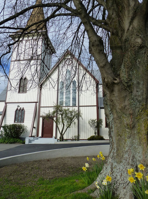
Designed by Benjamin Mountfort, the pre-eminent colonial architect in Canterbury, St Paul's Church is a very good example of his interpretation of Gothic forms in timber. The Church is planned according to the accepted nineteenth century principles for Anglican churches as established by the Ecclesiologists and Pugin. It is sited to orientate the sanctuary at the eastern end and the entrance opening to the north aisle near the western end. The open roofed nave is flanked by side aisles and crossed by wide transepts. At the eastern junction of the northern transept stands the bell tower. The separate sections of the steeply pitched roof articulate the various elements of the structure to provide a lively external silhouette. Exterior cladding is of vertical board and batten emphasising the building's verticality. A balancing horizontal element is provided by the string-course which has in part been lost. No longer painted to contrast with the colour of the main body of the building, the string-course motif has less emphasis than in many of Mountfort's timber church designs. When the original bell tower was replaced in 1912 the new tower closely followed the original design with its steeple crowned by a tall cross, repeating the smaller crosses which formerly sat at the apex of each gable. Internally, the timber braced and lined open roof structure and the dado are dark stained while the plaster walls are painted white. Diamond paned groups of lancet windows light the interior. These are of simple rectangular shape, while on the exterior a timber frame provides the traditional Gothic form, thus eliminating the need for the complex cutting of glass to fit the shapes. In the sanctuary at the eastern end a large trefoil window is surmounted by a rose window. Here is the church's only example of stained glass with the full height figure of St Paul taking the central position. At the western end of the nave are two pairs of tall lancets with smaller versions at the end of each aisle. Groups of three lancets are arranged along the nave and the clerestory and the transepts have large angle headed windows where the plain diamond paned glass has been recently over painted to illustrate fauna and flora. The Churchyard surrounding the Church features lawns, shrubs and a variety of mature trees. The entrance-way is flanked by carefully maintained flower beds and the World War I memorial plaque, originally placed on a gate, is located here. Closer to the Papanui Road intersection a pathway enters the Churchyard from Harewood Road. A pleasant rest area has been provided alongside this entrance, with seating and an information board which recounts the history of the Church and the site. The nature of the tombstones vary according to their age, with many imposing examples of Victorian styles and forms included. A large plot with small individual plaques commemorates the many members of the Matson family who have been buried here over the years.
Report Written By
Pam Wilson
Information Sources
Christchurch City Council
Christchurch City Council
Ciaran, 1998
Fiona Ciaran, Stained Glass Windows of Canterbury, New Zealand. A Catalogue Raisonne, Dunedin, 1998
Jacobsen, 1953
W. W Jacobsen, Parish of Papanui, 1853-1953, Christchurch, 1953
Land Information New Zealand (LINZ)
Land Information New Zealand
Lochhead, 1999
Ian Lochhead, A Dream of Spires: Benjamin Mountfort and the Gothic Revival, Christchurch, 1999
Mair, 1974
Mair and Hendry, More Homes of the Pioneers and Other Buildings. Christchurch, 1974
Orbell, 1928
W.H. Orbell, The Papanui Parish, A Brief History, 1853-1928, Christchurch, 1928
Report Written By
A fully referenced version of this report is available from the NZHPT Southern Region Office. Please note that entry on the New Zealand Heritage List/Rarangi Korero identifies only the heritage values of the property concerned, and should not be construed as advice on the state of the property, or as a comment of its soundness or safety, including in regard to earthquake risk, safety in the event of fire, or insanitary conditions.
Current Usages
Uses: Commemoration
Specific Usage: Memorial - World War One
Uses: Funerary Sites
Specific Usage: Cemetery/Graveyard/Burial Ground
Uses: Religion
Specific Usage: Church
Uses: Religion
Specific Usage: Churchyard
Former Usages
General Usage:: Commemoration
Specific Usage: Memorial - World War One
General Usage:: Funerary Sites
Specific Usage: Cemetery/Graveyard/Burial Ground
General Usage:: Religion
Specific Usage: Church
General Usage:: Religion
Specific Usage: Churchyard
Themes
War Memorial
Stay up to date with Heritage this month
