

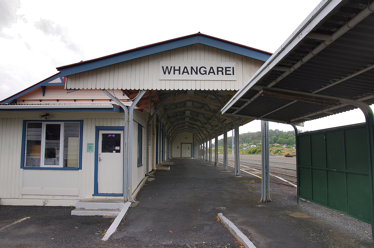
Constructed in 1924-5, the former Whangarei Railway Station reflects the expansion of New Zealand's railway system to outlying provincial centres in the early twentieth century, and Whangarei's emergence as Northland's largest settlement. Transportation in early Whangarei relied heavily on shipping, which connected coastal settlements in Northland to each other as well as major urban centres such as Auckland. Established as a colonial township in the 1860s, Whangarei's earliest railway line was constructed in 1879-80 to allow the export of coal from mines at nearby Kamo via the Whangarei wharf. The Kamo-Whangarei line remained isolated from the rest of New Zealand's rail network until the main trunk route between Auckland and Wellington was completed in 1908, allowing resources to be spent on connecting outlying provincial centres. In 1911, Whangarei was linked to the Kawakawa-Opua line further north, and by 1925 its connection to Auckland was complete. As a major focus for the rail network in the region, a large station complex was erected at Whangarei on a new site to the south of the town centre. The station was opened by the Minister for Railways and future premier, Gordon Coates (1878-1943), on 11 March 1925. The new complex incorporated a timber station building and canopy, a long platform and several ancillary buildings including a guards room, bicycle shed and dog boxes. Native trees may also have been planted to provide an aesthetic backdrop to the station. The main station building was one of the last to be designed under the direction of George Troup, who was an important figure in the development of New Zealand railway architecture in the early twentieth century. Costing between £8,000 and £9,000 to construct, the building was modelled on the Troup Type B and C design, incorporating a ticket office, luggage and refreshment facilities and office space for the station manager. The weatherboarded structure and its canopy were contained within a double-gabled roof, unlike subsequent designs such as the single-gabled Tauranga station (1928). The station complex continued to form a major gateway to the township throughout the mid twentieth century, also facilitating Whangarei's economic expansion during this period. As rail transport declined in the later 1900s, however, the station also became the focus of public bus services. Ancillary structures associated with the latter included the erection of a bus shelter in 1967, while modifications to the main station building were also made including the provision of more leisurely refreshment services. Mixed goods and passenger trains eventually ceased to stop at the station in 1977, although bus services continued to run until the 1980s. Following privatization of the rail network in the following decade, the station was sold to Whangarei City Council, since when it has been used for weekly markets, community meetings and other uses. It is currently occupied as offices and training facilities by the Prince's Trust (2005). The former Whangarei Railway Station is considered historically significant for its association with the development of New Zealand's railway network, particularly its extension to major provincial centres. It is also closely linked with Whangarei's development as a major economic centre in Northland, which was facilitated by improved communications with the rest of New Zealand. The station is architecturally important for incorporating a notable surviving example of a Troup Type B and C main station building, and as one of the last large stations whose construction was overseen by Troup. The station also has social value as a place of congregation for many years, a function that has continued intermittently in recent times.
Location
List Entry Information
Overview
Detailed List Entry
Status
Listed
List Entry Status
Historic Place Category 2
Access
Private/No Public Access
List Number
7646
Date Entered
3rd March 2006
Date of Effect
3rd March 2006
City/District Council
Whangārei District
Region
Northland Region
Extent of List Entry
The registration includes all of the land in RT NA103B/375, and the buildings, their fixtures and fittings, thereon. It incorporates the main station building and canopy; its additions; the station platform; the bus shelter and its associated platform; the car parking area to the northeast; and the existing kauri, pohutukawa and other mature trees within the area of the legal title. The proposed registration does not include any of the rail corridor to the south.
Legal description
Lot 1 DP 169438 (RT NA103B/375), North Auckland Land District
Location Description
Located at the southern terminus of Railway Road.
Cultural Significance
For many years the former Railway Station was a major public complex in Whangarei, and a place of significant social interaction. As the major arrival and departure point for many visitors and local travellers, it also formed a major gateway to the city. The station has continued to have a social role in the city since its use as a major transport hub, having been employed for markets, meetings and other gatherings.
Historic Significance
Historical Significance or Value The former Whangarei Railway Station is historically significant for its close association with the development of the North Auckland railway line, which performed a vital role in the growth and development of Whangarei. It is also of value as a major public complex, reflecting the emerging status of Whangarei as Northland's premier settlement. The station was a major component in the rail network north of Auckland and is associated with the extension of the network to major provincial centres not on the earlier trunk lines. The main station building and its associated components reflect the rise and fall of the railways as a passenger service, and the subsequent importance of road transport, particularly the public bus network.
Physical Significance
The former Whangarei Railway Station is architecturally significant for incorporating a notable example of a modified Troup type B and C station design. The main station building appears to be one of the last of its type to be constructed before a change in style to more evident bungalow features. It is also one of the last to have been erected under the architectural guidance of George Troup, who retired in 1925.
Detail Of Assessed Criteria
(a) The extent to which the place reflects important or representative aspects of New Zealand history: The former Whangarei Railway Station reflects the extension of rail transport to the northern provincial centres of New Zealand, and the growth of Whangarei as the premier settlement in Northland. Its subsequent use as a bus station reflects the replacement of rail transport with public bus services in the later twentieth century. (f) The potential of the place for public education: As a Council-owned complex located close to the centre of Whangarei, the place has good potential for public education about the history of rail transport and the development of Whangarei. Archives New Zealand holds good archival information on the railway station, which could be utilised for public education. (g) The technical accomplishment or value, or design of the place: The former Railway Station incorporates what is considered to be a notable example of a modified Troup Type B and C station. The Whangarei Railway Station (Former) is recommended for Category II registration as a place of historical or cultural heritage value because: - It is closely connected with the importance of rail as a major form of transportation in New Zealand during the 1920s, and the rise of public bus services in the later twentieth century; - It is strongly associated with the development of Whangarei as Northland's premier settlement from the early twentieth century; and - It incorporates a notable surviving example of a modified Troup Type B and C railway station building.
Construction Professional
Biography
G A Troup (1863-1941) was born in London in 1863 and educated in Scotland. He trained as an architect and engineer under C E Calvert of Edinburgh and came to New Zealand in 1884. After a short time with the Survey Department in Otago he became a draughtsman for New Zealand Railways in Dunedin and then, from 1888, in Wellington. Troup became Chief Draughtsman in 1894. He designed many station buildings throughout the county, some of which are still in use today; these buildings form an important part of New Zealand's landscape. His best known building is the Dunedin Railway Station (1904-07). He also designed the head office building in Wellington for Railways (1901, now demolished). Troup became a Fellow of the Royal Institute of British Architects in 1907. After World War I he was promoted to head the newly established Architectural Branch of New Zealand Railways. On retirement from Railways in 1925 he entered local body politics and was Mayor of Wellington from 1927 to 1931. Troup was prominent in the Presbyterian Church and founded the Presbyterian Young Men's Bible Class Union. He was an elder of the church for 47 years and also served on the governing bodies of several Wellington secondary schools. Education was a life-long interest and he was keenly involved in the training of engineering cadets in New Zealand Railways. Troup was knighted in 1937 and died in 1941. Last updated 1 October 2014 See also: James Veitch. 'Troup, George Alexander', Dictionary of New Zealand Biography, first published in 1993. Te Ara - the Encyclopedia of New Zealand, https://teara.govt.nz/en/biographies/2t49/troup-george-alexander
Name
Troup, George Alexander
Type
Architect
Construction Details
Description
Main station building, including canopy
Start Year
1924
Type
Designed
Description
Platform and main station building, including canopy. Ancillary structures also erected
Finish Year
1925
Start Year
1924
Type
Original Construction
Description
(11 March 1925) Main station building, including canopy. Kauri trees may also have been planted as landscaping
Start Year
1925
Type
Other
Description
Minor alterations to main station building and ancillary structures
Finish Year
1927
Start Year
1926
Type
Modification
Description
Shortening of rail platform for construction of bus shelter
Start Year
1967
Type
Modification
Description
Bus shelter
Start Year
1967
Type
Original Construction
Description
Extension of, and internal alterations to, main station building
Finish Year
1968
Start Year
1967
Type
Modification
Description
Screens added to bus shelter
Start Year
1969
Type
Modification
Description
Small addition to western end of main station building, and internal alterations
Start Year
1979
Type
Modification
Description
Demolition of ancillary structures to east of main station building
Type
Modification
Construction Materials
Main station building - timber with corrugated iron roof Rail platform canopy - timber with corrugated iron roof, structural members of recycled railway iron, steel I-beam at eastern end Rail platform - concrete with asphalt surface Bus shelter - steel columns with corrugated iron roof and concrete dividing screen
Early railway construction in Whangarei: Whangarei's emerged as a colonial settlement in the 1860s, from which time its main link with other settlements was by sea. Numerous goods were shipped to the Auckland market, including fruit, potatoes, cattle, firewood, flax, kauri gum and coal. Coal formed a significant export, having been discovered just inland from the Whangarei harbour in the 1850s. By the following decade a mine at the Whau Valley was operating, which employed a tramway to transport the coal to Whangarei wharf for shipment. In 1875, mining operations began at Kamo, from where coal was initially transported to Whangarei by road. Due to difficulties in negotiating the terrain in winter, work on Whangarei's first railway was carried out in 1879-1880. The Whangarei-Kamo line connected the mines and the wharf via a track three miles in length, which was extended by two miles in 1882, to a new wharf built in deeper water at Opau (Kioreroa). A small timber railway station was erected at the new wharf terminus, with further stations erected at Whangarei township, Kamo (Ruatangata) and the Kamo coal mine. The station at Whangarei township was equipped with an engine and carriage shed, and a small workshop. Connection of Whangarei to the main rail network: The Whangarei-Kamo railway was part of the Vogel government's large-scale public works programme, which was funded by overseas borrowing. However, although the rail network expanded significantly in other parts of the country, comparatively little activity was directed at developing rail access north of Auckland. With the general slowdown of railway construction during the economic depression of the 1880s and 1890s, only a minor expansion in Northland's rail network took place prior to the twentieth century. Whangarei's railway remained isolated from other parts of the national system until this time. Completion of the main North Island main trunk line connecting Auckland with Wellington in 1908 allowed work to proceed with renewed vigour in other sectors, including the line north from Auckland. By 1909, Wellsford was reached. Work was also undertaken on the network north of Whangarei, and in 1911 the town was linked to the Kawakawa-Opua line. Passengers could now travel from the Bay of Islands to Auckland, and vice versa, by transferring between the northern rail network and the Auckland steamer service at a new deep water wharf and station at Onerahi, built on an extension of the Whangarei line. In order to cope with the increase in both freight and passengers, the station in Whangarei township was extended at the turn of the twentieth century, and again in 1912 and 1920. By 1923 it was possible to travel the entire distance between Auckland and Whangarei by rail, although the trip involved transferring from New Zealand Rail-operated trains to those run by the Public Works Department over lines still under construction. The works were completed in 1925, after which the Auckland-Opua express ran daily between Auckland and Whangarei and thrice weekly between Whangarei and Opua. The connection of Whangarei and the northern network to the rest of the rail system marked a significant event in the completion of the basic skeleton of New Zealand Railway, with the Auckland to Opua link being one of several important provincial lines finished in the 1920s and 1930s. Work on further expanding the national network was comparatively limited, with the inter-war period marking the apogee of rail transport in New Zealand. Whangarei's connection to the network also provided the town with a major economic boost, growth having previously been restricted by poor roads and inadequate steamer services. The town's population expanded by nearly 50% between 1926 and 1945, well above the national average rate of increase. This cemented Whangarei's role as the premier settlement in Northland during this period. The New Station: Consideration was given to improving railway facilities at Whangarei including the provision of a new station as early as 1917. Business was expected to increase rapidly with the impending rail connection to Auckland, and the old station yard was considered to contain insufficient room for further sidings. A new site for a larger station was chosen, approximately a quarter of a mile from the existing station, on the opposite (southern) side of the Waiarohia Stream. Lying close to the town centre, the land for the new station yard was secured in the early 1920s. A major force behind the station improvements at Whangarei was George Troup, who had a key role in the design of the country's railway stations in the first quarter of the twentieth century. During his time with the railways department, Troup designed numerous important district and provincial stations as well as some major city stations. The railways underwent a major phase of station construction prior to the First World War (1914-18), although by the 1920s and 1930s building work was carried out in a more piecemeal fashion. Troup retired from the railways department in 1925, and it was towards the end of the Troup era that the Whangarei railway station was planned and constructed. In July 1921 Whangarei was visited by Mr R.W. McVilly, general manager of railways, who brought plans of a new station with him and looked over the new site. These proposals may have been superseded in the following year, when a two-storey station building was designed, accommodating offices associated with the running and management of rail services in the Northland district as well as large general and ladies waiting rooms on the ground floor. A modified plan was soon developed encompassing a single-storey timber station building, with accommodation for the district headquarters to be provided in a separate structure. The new station building was to be part of an extensive network of railway structures on either side of the North Auckland line, with buildings in the wider complex to include a large engine shed capable of housing twelve compound locomotives. By mid 1924, earthworks on the site were well underway and a substantial building in permanent materials for the district staff had also been built nearby. By September 1924 the new engine shed and turntable was in place, along with a number of other railway buildings. In October 1924, attention turned to the new station buildings, with a concrete front for the platform due to be constructed. The Whangarei Chamber of Commerce expressed their view that brick or concrete should be the material of choice for the main station building, possibly because these were seen as more prestigious and thus suitable for Northland's premier settlement. Most smaller provincial and local stations were erected in timber, a more amenable material to alter and cheaper to construct, while larger stations at Dunedin, Wellington and Auckland, were of stone, brick or other durable fabric. By October 1924 the foundations of the new station building were complete but the erection of the rest of the structure was delayed by the late arrival of building materials. The station was built of timber, as planned, and as a key station in the Northland rail network, was of substantial appearance. The station's design was broadly based on the type B and C standard plans used by the railways department, whose gable-roofed appearance generally formed the baseplate for station buildings in larger towns. Like other stations of the era erected in sizeable settlements, the Whangarei station was individually designed, being considerably wider than either the B or C standard plans. In the new station building, sizeable areas were given over to the luggage and parcels hall and refreshments room located in the eastern and western ends of the building respectively. Impressive kitchen facilities included separate storeroom, cool room and milk store all built off a hall, with access from both the road approach and the rail platform. The central portion of the station accommodated the booking hall/booking office, the Station Master's office and the waiting room. Late in the project a small part of the waiting room, was - with the addition of a bay window onto the platform - transformed into a bookstall. A long canopy provided shelter for passengers and staff along much of the platform. The station was officially opened on 11 March 1925 by the Minister of Railways and future premier, Gordon Coates (1878-1943), at a ceremony attended by over 500 people. Coates had become the youngest minister in the National government in 1919, being given the portfolios of Public Works in 1920 and Railways in 1923. He formally opened three facilities in Whangarei on the same afternoon: the railway station, a new concrete bridge over the Waiarohia Stream in Water Street, and the Public Trust office - at that time Whangarei's largest building, constructed to house government offices under one roof. Two kauri trees to the west of the station building are said to have been planted on the opening day, while later photographs indicate that an arc of trees along the townward side of the complex were established as an aesthetic backdrop to the station building in its early years, if not at the time of its creation (see p.37 of this report). The station building had cost between £8,000 and £9,000, with the station yard costing another £87,000. The total sum expended was nearly double the £50,000 estimated for the project in 1921 and the project had taken considerably longer than initially expected. To help reduce costs, parts of the former station building in Whangarei was re-used. While a portion of its verandah was removed and installed at Hikurangi, most of the remainder of the building was integrated into the new District offices. Other parts of the old station building were re-used in the new station complex, including one element converted into the guard and porters room. Former ancillary structures were also transferred, such as the former guard and porters room, which was re-used as a bicycle store. These complemented new structures on the recently-opened station site, including six dog boxes installed in September 1925. Small modifications appear to have been made to the new station building and its ancillary structures in 1926-7. Subsequent development: The New Zealand railway system dominated the land transport of both passengers and freight in the 1930s and during the Second World War (1939-1945). Northland's roads were initially slow to develop, earning it the description 'the roadless north'. In 1934 an all weather road connected Auckland with Whangarei, but further improvements would be needed before road transport could compete with the railways. Sea transport also declined, and in 1931, the Northern Steamship Company - which had provided Whangarei with a regular scheduled passenger and freight service to Auckland since 1891 - ceased its passenger services. A large increase in rail freight and passengers occurred during the war years as petrol and rubber shortages affected alternative means of transport. Although increased competition from roads led to a decline in the 1950s, the number of stations in New Zealand remained relatively constant and their business substantially intact. Whangarei continued to expand in this period, partly due to its better links with the rest of New Zealand. In 1951 its population was 15,431, in 1956 18,369, and in 1961 21,790. The settlement gained city status in 1964, the only place to achieve this north of the Auckland isthmus. In the face of growing competition from roads, the railways department had itself begun operating a regular road service connection between Whangarei and Auckland during the war, and upgraded its trains from steam to diesel-powered locomotives on the Auckland-Opua express in 1956. Ancillary structures erected or used within the station complex during the 1950s include a pigeon shed - employed by the Whangarei Homing Pigeon Club - and a mens toilet block to the east of the main station building. By 1960, however, parcels and freight were no longer carried through Whangarei by rail, and in 1967 dedicated passenger trains were replaced with bus services. Instead, some of the goods trains were equipped with passenger cars on certain sections of the line. These mixed trains continued to provide regular passenger services until mid 1977 when the mixed train between Whangarei and Opua became the last scheduled mixed train to run in New Zealand. The NZR passenger buses used the railway station as a terminus from November 1967. The following month, a bus loading shelter was opened to the west of the station building, allowing temporary cover for people and goods while transferring between rail and road transport. This involved removing part of the earlier platform. Internal alterations to the main station building were also made to provide facilities for the road services staff. The refreshment rooms were also modified so that they could be accessed from the roadside and a more leisurely type of catering provided. Suggested alterations to the complex in the following year included the removal of seven pohutukawa trees in the station grounds to improve the bus and car parking facilities, while in July 1969 the bus shelter was modified to incorporate a central screen. This followed criticism about the poor design of the original structure. The 1980s and 1990s brought further changes for the railways, with air travel also becoming increasingly affordable. The railways responded by reviewing its services with a view to improving financial performance. Unprofitable branch lines, stations and sidings were closed while money directed towards improving the well-used North Island main trunk line. Many changes planned by the railways department in the early 1980s were carried out by its successor, the New Zealand Railways Corporation, which came into being on 1 April 1982. The corporation had more commercial freedom than its predecessor and it was hoped that the new entity would become the profitable enterprise that the railways department once was. In 1984 land transport was deregulated by an act of parliament, at which time restrictions on competition that had existed since the 1930s were removed. The Whangarei railway station was one of many to be closed as an operational building during this period. Railway operations were removed to the other side of the railway tracks and the road services department relocated prior to 1990. New Zealand Rail Ltd. - itself formed in 1990 - was sold by the government to private interests in 1993. In 1995 the railway land at Whangarei was subdivided, with the station building parcelled within a narrow 1.2 hectare allotment. Two years later, the station property was acquired by Whangarei District Council. Since its closure, the station has been visited by a number of steam trains including the Crunchie vintage steam train excursion in 1993. This carried 100,000 passengers on its journey from Invercargill to Whangarei, in imitation of a similar train featured in a famous advertising campaign for Cadbury's Crunchie bar during the 1970s. The 1993 trip was a marketing exercise by the chocolate manufacturer, in conjunction with steam train enthusiasts and other enterprises, and the three-week trip terminated at the Whangarei Railway Station. The station has since been a popular stop for other excursion trains run by train enthusiasts. Following its purchase by the Council, the station building and trees on its associated land were considered for removal to allow for the construction of a road connecting with Okara Drive. They were reprieved in 2001 when an alternative route was chosen. Before this period and subsequently, the station building has been put to alternative uses. In 2000 it became a community venue, hosting live musical performances, weekly markets and meetings of local community groups, including a transgender support group - Agender - and the Northland Disabled Persons Assembly. At this time, volunteers reglazed damaged windows as part of restoration works undertaken by the community group 'People Going Ahead' (also known as PGA Enterprises). In early 2002, Phoenix taxi cabs moved their base to the station, working from a small self-contained cabin added at the western end of the building, and the building was also used for raves attended by the city's teenagers. These were discontinued in August 2002, despite the Whangarei District Council subsequently receiving a 1500 signature petition requesting that they be allowed to continue. From late 2002 the station has been occupied by the Prince's Trust, who provide training for young unemployed adults. Trainees have undertaken some refurbishment work during the Trust's tenure of the building as a practical application of their training. The adjacent railway lines and shunting yard continue to be used to carry freight, including containerized freight and logs from Northland forests. Some ancillary buildings within the complex, including those to the east of the main station building, have been demolished at an unknown time since the 1960s.
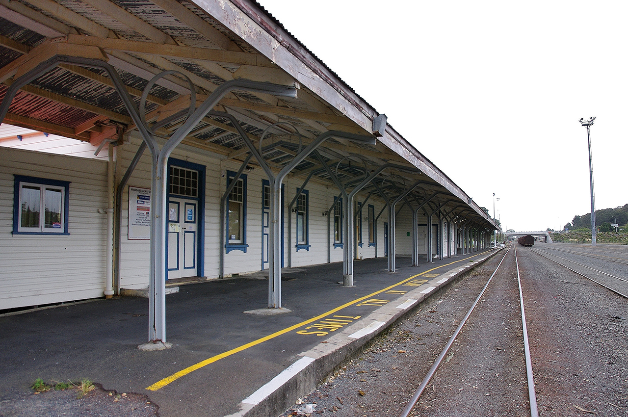
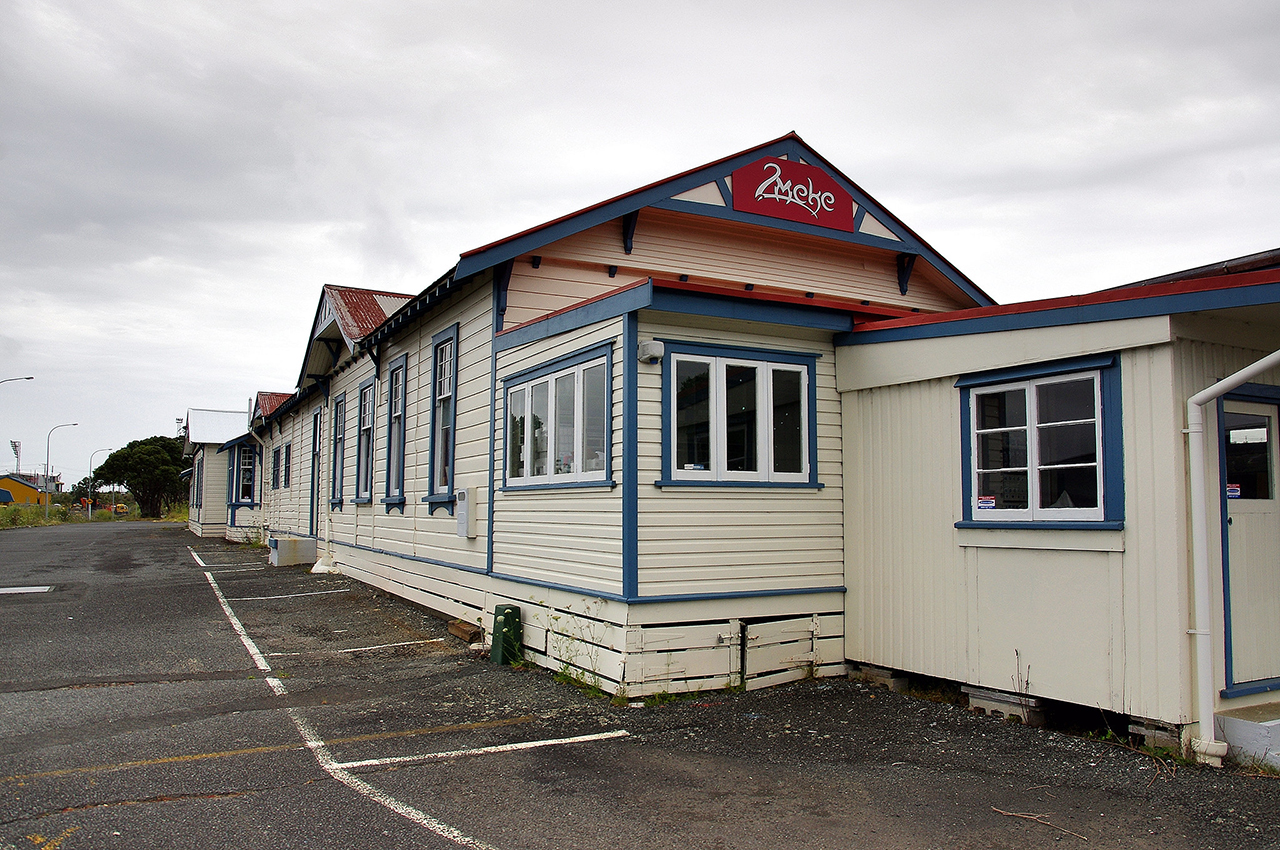
Context: The station is located to the south of the Whangarei Central Business District (CBD), between the hills of suburban Morningside and the Hatea River, northwest of the Limeburners Creek bridge. The site occupies flat ground beside the North Auckland Railway, at the southern end of Railway Road. The northern part of the property is bounded a stream, while the working North Auckland rail line runs past the station on its southern side. To the south of the line, a large area of former shunting and marshalling yards remains as open space, used in part for railways purposes and in part for other freight and storage functions. Some corrugated iron goods sheds or engine sheds, now converted to other uses, survive across the former marshalling yards. Neither the railway line nor the yards are included in the registration. The station complex : The station complex incorporates a long platform - supporting a large timber station building and its canopy - a separate bus shelter to the west, an area of tarmac car parking to the north, and several native trees concentrated mainly towards the western and eastern end of the complex, although they originally formed an arc around the main building. All of these elements are included within the registration. The station building and other major components are oriented from northwest to southeast. For the purposes of this description, these are described as if they were oriented west to east rather than northwest to southeast. Main station building and canopy - exterior: The early fabric of the station building appears to be substantially intact, though there have been a number of alterations and some additions. The main building consists of a shallow-gabled weatherboard structure with a corrugated iron roof. Its joinery is of timber, including both double hung and casement windows. A freestanding gable on its southern side forms a canopy over the platform. This is supported by a double row of Y shaped railway iron columns with timber rafters, wooden sarking and a corrugated iron roof. The canopy appears to have been shortened at its eastern end, where a steel I beam structure appears to be a more recent addition. The canopy extends beyond the length of the station building at its eastern end. Although based on Troup's B and C designs, the station building is broader than the standard measurements for types B and C. It measures between 7.5 m. and 9.1 m. in width, whereas the B and C designs measure 5.2 m. and 6.1 m. wide respectively. The station building is 72 metres long, while the adjacent canopy over the platform is currently 90 metres long Under the central part of the canopy, a new weatherboard room with aluminium joinery has been added to the main station building (serving as the NZR Road Services ticket and waiting room from the 1960s, as noted above). Two small cabins have also been placed against the western end of the same building. These have nearly flat-pitched corrugated iron roofs, respectively associated with horizontal and vertical weatherboard walls. One of the structures is accessible from the station building interior. The other, most recently used by Phoenix Taxis, has only external access. On the main elevation to Railway Road and the car parking area, three gablets project from the roof. The one at the eastern end is above the luggage room, the central one above the original waiting room, ticket office and street entrance (now closed) and the western one is over what is now office space. At the eastern end of the same elevation, a sloping concrete ramp provides access from street level to the platform. A concrete loading platform with steps for access is also situated outside the double doors giving entry to the luggage room. Main station building - interior: The roof is supported on timber trusses, with longitudinal sarking. Interior linings vary widely, ranging from some original vertical tongue and groove timber match lining in some spaces, to the most recent, lined with plaster board, and others which include fibrolite, hardboard and plywood, reflecting changing internal refurbishment, rearrangement and adaptation to changing function. Significant details survive, including a luggage hatch in the luggage room, and occasional signage. The platform, bus shelter and station grounds: The long tar-sealed concrete platform on which the main station building stands has sloping ramps at either end, and is also accessed at the southern end of the station building by a concrete ramp. At the eastern end of the platform are the brick and concrete foundations of a men's toilet block and other storage buildings that formerly stood here. Two concrete footings for I beams on the platform indicate the former location here of another added structure, possibly an awning or luggage stand. At the western end of the station is the bus platform, formed as an area of raised tar-sealed kerb. Its associated bus shelter - erected in the late 1960s - consists of a shallow V shaped corrugated iron roof supported on central I-beam columns. A concrete block wall forms a central screen for part of the structure, with wooden bench seats on either side. In the grounds at the western end of the station complex are two kauri trees either side of (and growing up through the foliage of) a pohutukawa tree. These kauri are said to have been planted on the occasion of the opening of the station. Other mature trees survive along the northern fringes of the complex towards its eastern and western ends, and appear to be the remnants of historic plantings forming a landscaped backdrop to the station. Trees previously located in the central part of the northern boundary are now largely absent, having evidently been removed in the late 1960s to improve parking facilities for buses and cars. Most of the rest of the ground is occupied by a tar-sealed access road and car parking areas. Architectural comparisons for the main station building: The main building at Whangarei Railway Station was identified by P.J. Mahoney in 1990 as one of just six Troup Period Type B and C buildings that could be regarded as 'notable survivors'. The others are at Waihi (1905), Rangiora (1906), Otaki (1908), Kawakawa (1911) and Glenhope (1912). Whangarei is the only one of this group to have been constructed after the First World War. Mahoney carried out a survey of railway station buildings of the period 1863-1845 and recommended the conservation of 42 surviving stations. These form a small number of the more than 1400 stations built during the period. Of the six notable Troup Period Type B and C buildings identified by Mahoney, the NZHPT Register of Historic Places, Historic Areas, Wahi Tapu and Wahi Tapu Areas currently includes: # 4099 Otaki Railway Station, Category II historic place, # 4664 Waihi Railway Station, Category II historic place, and # 5172 Glenhope Railway station, Category II historic place. Kawakawa and Rangiora are not registered. No railway stations of any type north of the Auckland metropolitan area are currently registered The Whangarei station is said to have been similar in design to the Tauranga station built some three years later. However, the latter has strong bungalow elements and incorporates its canopy under the same roof as the main station building, unlike the double-gabled appearance of the Whangarei Station. It may be, however, that it contains a similar groundplan. Differences in visual appearance between the two structures may be connected to George Troup's retirement from New Zealand Railways between their respective construction dates. Current physical condition: The building appears to be in sound physical condition. There has been extensive minor damage done to interior surfaces during several tenancies in the last decade, and some deterioration through lack of maintenance. The current lessee (The Prince's Trust) has undertaken a considerable amount of repair, refurbishing and repainting, including exterior repainting. That programme of work is continuing.
Report Written By
Martin Jones, Tania Mace and Stuart Park
Information Sources
Appendices to the Journals of the House of Representatives (AJHR)
Appendices to the Journals of the House of Representatives
Archives New Zealand (Auck)
Archives New Zealand (Auckland)
Geoffrey, 2001
B Geoffrey, Churchman and Tony Hurst, The Railways of New Zealand: A Journey Through History, Wellington, 2001.
Hansen, 1992
H.J. Hansen, Tracks in the North, Auckland, 1992
Whangarei Leader
Whangarei Leader
Land Information New Zealand (LINZ)
Land Information New Zealand
Leitch, 1988
David Leitch and Bob Stott, New Zealand Railways: The First 125 Years, Auckland, 1988
Mahoney, 1987
J. D. Mahoney, Down at the Station: A Study of the New Zealand Railway Station, Palmerston North, 1987
Mahoney, 1990
Mahoney, P. J., 'New Zealand Railway Station Buildings: A Heritage in Timber and Tin', Proceedings of the First ICOMOS New Zealand Conference, 1990
Northern Advocate
Northern Advocate
Sunday News
Sunday News
Report Written By
A fully referenced registration report is available from the NZHPT Northland Area Office Please note that entry on the New Zealand Heritage List/Rarangi Korero identifies only the heritage values of the property concerned, and should not be construed as advice on the state of the property, or as a comment of its soundness or safety, including in regard to earthquake risk, safety in the event of fire, or insanitary conditions.
Current Usages
Uses: Education
Specific Usage: Adult Education/training
Former Usages
General Usage:: Civic Facilities
Specific Usage: Community centre
General Usage:: Trade
Specific Usage: Market
General Usage:: Trade
Specific Usage: Office building/Offices
General Usage:: Transport
Specific Usage: Bus Station/Depot/station/shelter
General Usage:: Transport
Specific Usage: Railway station/ platform/ refreshment room
Stay up to date with Heritage this month
