

Lots 3 and 4 were purchased in December 1875 by chemist James Sharland (1819-1887). Sharland had set up in business as a chemist, druggist and general merchant in Taranaki in 1847, and is said to have brought the first recorded supply of drugs to New Zealand. He was also New Plymouth's representative on the Provincial Council in the 1850s and 1860s. After relocating to Auckland, Sharland's enterprise outgrew premises in the Queen Street area necessitating the construction of a new building in Kitchener and Lorne Streets, close to the Princes Street site. Particularly after publishing his Settlers' Guide and Household Companion on health matters in 1878, Sharland became a household name. Like many other Auckland merchants, he prospered in the economic boom of the 1870s.
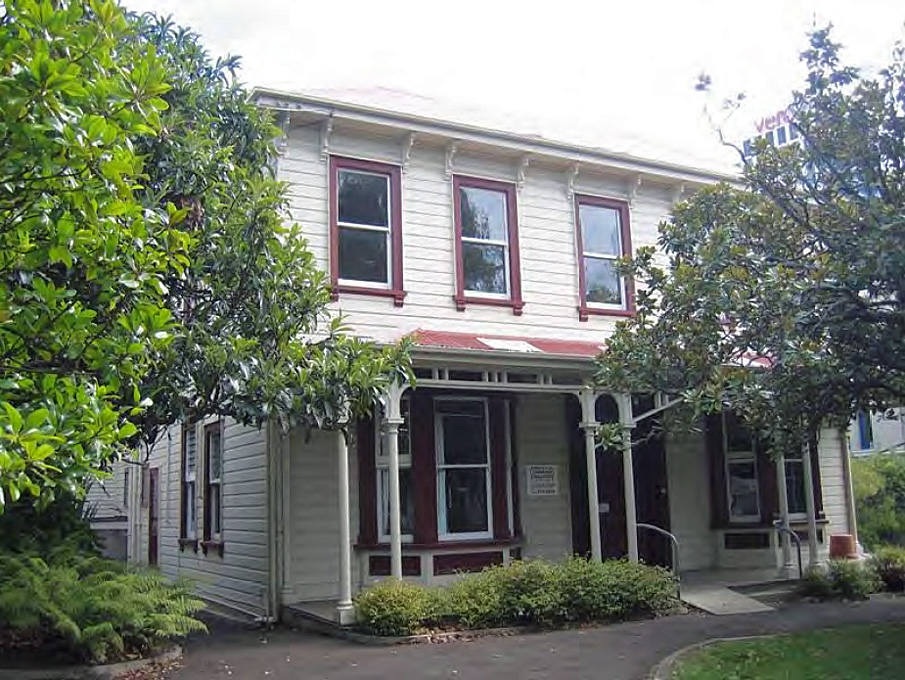
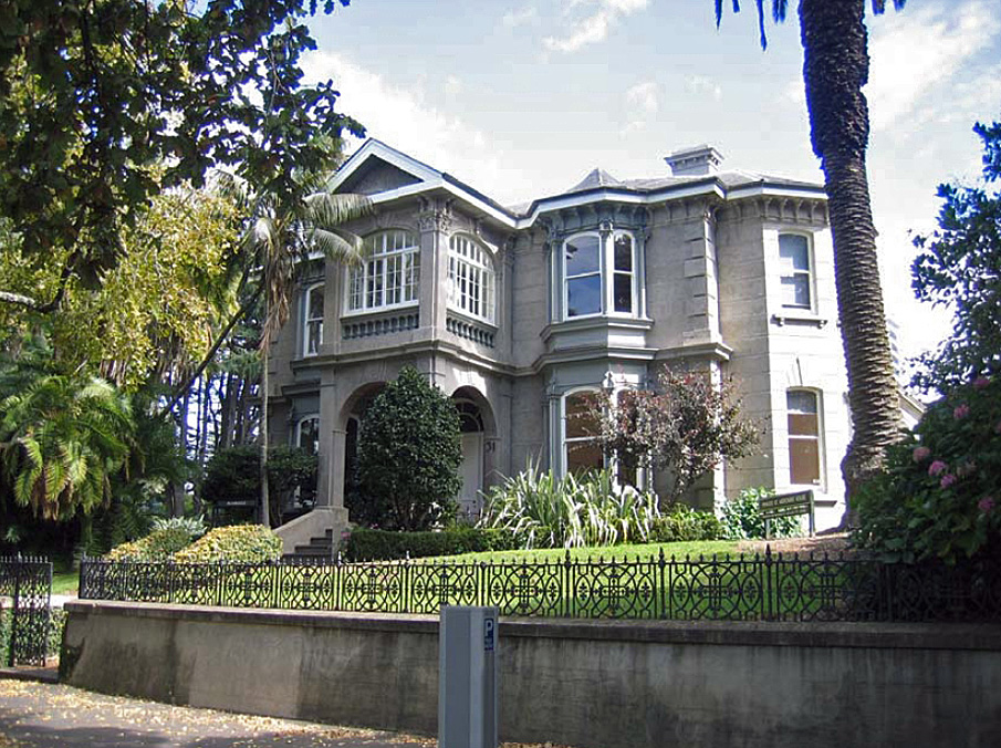
Sharland constructed a large family house on the site in 1877-78, designed in a comparatively restrained Italianate style. Italianate architecture was often used for mercantile premises and residences in Auckland during the late Victorian period, being modelled on the designs of Italian Renaissance buildings erected from the proceeds of commercial wealth. Situated on the crest of a ridge, the house overlooked the general location of Sharland's business. Its designer and builder are unknown. Externally, the timber residence incorporated a flat frontage with a single-storey verandah. Internally it contained a wide central passage with large flanking rooms. Service areas were located to the south of the hall at the west end of the building. Several bedrooms were located upstairs. The residence was ornamented to a reasonable standard, with board and batten ceilings in most rooms.
For about three years following Sharland's death in 1887, his brother-in-law, Philip Philips lived in the house. Philips was a former mayor of Auckland who had been instrumental in having the Albert Barracks site vested in the Auckland Improvement Commission in the 1870s. He had also helped to establish the town's main synagogue on an immediately adjacent site in 1884-85. A leading member of the Jewish community and town clerk for 25 years, he can be considered Auckland's most prominent local government officer during the late colonial period. Shortly after his departure, the residence became a boarding house known as Sonoma, and by the early 1900s additions had been made. Occupation intensified with its conversion into flats in 1922, a function it retained until the 1950s. By 1954 the building was occupied by the Auckland University College as an Adult Education Centre. Along with adjacent houses, it was saved from demolition in the early 1970s and is currently (2007) used as a day centre for pre-school children.
Sonoma has aesthetic significance for its street and park setting, its striking external appearance and ornate detailing. It is considered to have archaeological value, incorporating evidence for remains connected with the Albert Barracks and other deposits linked to residential urban occupation. The main residence is architecturally significant as a well-preserved example of an elite urban dwelling in Auckland and as an example of an Italianate timber residence. It is of historical value for demonstrating the transformation of a major urban area into an exclusive residential neighbourhood for Auckland's commercial and professional elite in the late nineteenth century, and for reflecting the wealth and lifestyle of such groups and their prominent position in Auckland society. It is a significant part of an outstandingly important cultural and historical landscape on the Symonds Street ridge that retains numerous archaeological sites, historic buildings and other places linked to its role as the epicentre of early British colonial power in New Zealand, and as a subsequent residential neighbourhood of note.
List Entry Information
Status
Listed
List Entry Status
Historic Place Category 2
Access
Private/No Public Access
List Number
7730
Date Entered
15th February 2008
Date of Effect
15th February 2008
City/District Council
Auckland Council
Region
Auckland Council
Extent of List Entry
Extent includes the land described as Lot 1 DP 114585 (RT NA65B/7), North Auckland Land District and the building and structures thereon, and their fittings and fixtures. (Refer to map in Appendix 1 of the registration report for further information). The registration encompasses all archaeological material within the extent described above.
Legal description
Lot 1 DP 114585 (RT NA65B/7), North Auckland Land District
Location Description
On the western side of Princes Street, to the south of its junction with Bowen Avenue
Why is this place significant?
Historic Significance
Historical Significance or Value The place is historically important for its connections with the Albert Barracks and early military activity in New Zealand. It is particularly significant for demonstrating the transformation of a major urban area into an exclusive residential neighbourhood for Auckland's commercial and professional elite in the late nineteenth century. The place reflects the wealth and lifestyle of such groups and their prominent position in Auckland society. It is associated with later developments in urban history, including the growth of the University of Auckland in the twentieth century and attitudes to heritage protection in the early 1970s.
Physical Significance
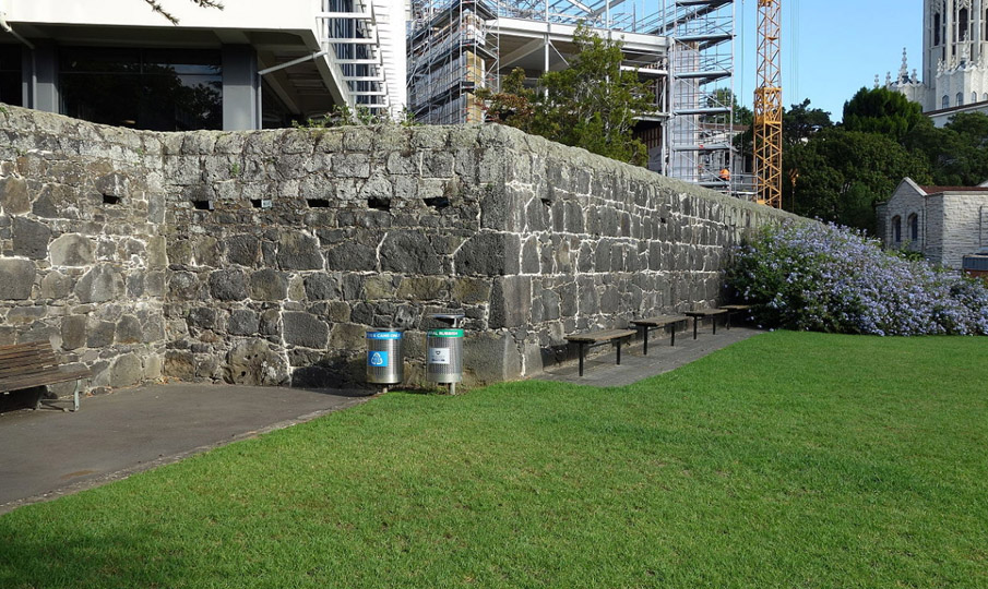
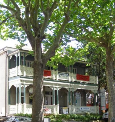
Aesthetic Significance or Value The place has aesthetic significance as an elite late-Victorian urban residence designed in an ornate, Italianate style. It has considerable value for its prominent contribution to the visual amenity of the Princes Street and Albert Park landscapes; for the grand appearance of its main residence, and for the quality of its surviving external and internal detailing. It is aesthetically important as one of a conjoining group of high-quality and ornate historic residences on the western side of Princes Street. Archaeological Significance or Value The place has archaeological value as part of the Albert Barracks complex, the largest and most important military installation in early colonial New Zealand. Evidence exists that the place contains the buried remnants of a military road, located immediately outside the main Barracks wall. The place can also be considered significant for its later colonial use as an elite urban residence. Elements associated with this activity include the comparatively well-preserved main residence and garden features. Nearby excavations have indicated that buried archaeological deposits linked with residential and related activity are likely to survive. The archaeological value of the place is enhanced as it is a rare survival of an elite residence and curtilage within the urban centre of colonial Auckland. Architectural Significance or Value The place has architectural significance as a well-preserved elite urban residence in late nineteenth-century Auckland. It is architecturally significant as a well-preserved example of a timber villa designed in the Italianate style. Its value is enhanced by the survival of adjoining residences of similar style and date which reflect the range of expression in Italianate design of the 1870s and 1880s.
Why is this place Category 1 / Category 2?
Detail Of Assessed Criteria
(a) The extent to which the place reflects important or representative aspects of New Zealand history The place has significance for its association with British military activity in New Zealand, and Auckland's function as early colonial capital. It is of particular value for reflecting the economic boom of the 1870s and early 1880s, Auck-land's ongoing role as a major commercial entrepot, and the social prominence of Auckland's mercantile and professional elite. The place is also important for reflecting the emergence of exclusive residential neighbourhoods based on wealth in late nineteenth-century urban society. It has connections with Auck-land's Jewish community and the nineteenth-century pharmaceutical trade. (b) The association of the place with events, persons, or ideas of importance in New Zealand history The place has strong associations with individuals of significance, including the provincial politician, merchant and author James Sharland, and the former mayor of Auckland and town clerk, Philip Philips. (c)The potential of the place to provide knowledge of New Zealand history The place has potential to provide knowledge of New Zealand history, particu-larly the activities of the British Army in the early colonial period. The place is notable for incorporating the probable (and rare) archaeological remains of a military road. A study of this has the capacity to improve knowledge about the organisation and operation of colonial military garrisons in general, and the Al-bert Barracks in particular. The place also has potential to provide knowledge about the functioning and economy of elite urban households in late nineteenth-century Auckland. Con-sidered likely to incorporate a range of material linked to its use as a residence, it probably has particular capacity to supply information about the lives of wealthy mercantile and professional families in one of New Zealand's largest colonial urban centres. (f) The potential of the place for public education The place has considerable potential for public education about the military, commercial and residential history of colonial Auckland, being a highly visible Council-owned property on the fringes of a major park. Lying within Auckland's busy city centre, its potential is enhanced by its location close to two major edu-cational institutions - the University of Auckland and the Auckland University of Technology. (g) The technical accomplishment or value, or design of the place The place has some value as a well-preserved example of an elite urban resi-dence in Auckland, and as a well-preserved timber villa of urban type designed in the Italianate style. (i) The importance of identifying historic places known to date from early periods of New Zealand settlement The place is considered likely to incorporate archaeological remains linked with the Albert Barracks, which was operational during the first three decades of New Zealand's colonial history. (k) The extent to which the place forms part of a wider historical and cultural complex or historical and cultural landscape The place is a significant element within a historical and cultural landscape of outstanding importance. The northern part of the Symonds Street ridge incor-porates places of significance to Maori and was the epicentre of British adminis-trative and military power in New Zealand. It also incorporates significant heri-tage linked with the redevelopment of the area as an exclusive residential and recreational neighbourhood in the late nineteenth century, its ongoing focus as a centre for wealthy residential and medical activity, and its occupation by the University of Auckland during the late nineteenth and twentieth century. The importance of the place is enhanced as one of a group of residences of similar age and style that reflect variations in Italianate style, and both the indi-viduality as well as collective identity of their mercantile owners. Summary of Significance or Values This place was assessed against, and found it to qualify under the following criteria: a, b, c, f, g, i, k. Conclusion It is considered that this place qualifies as a Category II historic place.
Why is this place significant?
Historic Significance
Historical Significance or Value The place is historically important for its connections with the Albert Barracks and early military activity in New Zealand. It is particularly significant for demonstrating the transformation of a major urban area into an exclusive residential neighbourhood for Auckland's commercial and professional elite in the late nineteenth century. The place reflects the wealth and lifestyle of such groups and their prominent position in Auckland society. It is associated with later developments in urban history, including the growth of the University of Auckland in the twentieth century and attitudes to heritage protection in the early 1970s.
Physical Significance
Aesthetic Significance or Value The place has aesthetic significance as an elite late-Victorian urban residence designed in an ornate, Italianate style. It has considerable value for its prominent contribution to the visual amenity of the Princes Street and Albert Park landscapes; for the grand appearance of its main residence, and for the quality of its surviving external and internal detailing. It is aesthetically important as one of a conjoining group of high-quality and ornate historic residences on the western side of Princes Street. Archaeological Significance or Value The place has archaeological value as part of the Albert Barracks complex, the largest and most important military installation in early colonial New Zealand. Evidence exists that the place contains the buried remnants of a military road, located immediately outside the main Barracks wall. The place can also be considered significant for its later colonial use as an elite urban residence. Elements associated with this activity include the comparatively well-preserved main residence and garden features. Nearby excavations have indicated that buried archaeological deposits linked with residential and related activity are likely to survive. The archaeological value of the place is enhanced as it is a rare survival of an elite residence and curtilage within the urban centre of colonial Auckland. Architectural Significance or Value The place has architectural significance as a well-preserved elite urban residence in late nineteenth-century Auckland. It is architecturally significant as a well-preserved example of a timber villa designed in the Italianate style. Its value is enhanced by the survival of adjoining residences of similar style and date which reflect the range of expression in Italianate design of the 1870s and 1880s.
Why is this place Category 1 / Category 2?
Detail Of Assessed Criteria
(a) The extent to which the place reflects important or representative aspects of New Zealand history The place has significance for its association with British military activity in New Zealand, and Auckland's function as early colonial capital. It is of particular value for reflecting the economic boom of the 1870s and early 1880s, Auck-land's ongoing role as a major commercial entrepot, and the social prominence of Auckland's mercantile and professional elite. The place is also important for reflecting the emergence of exclusive residential neighbourhoods based on wealth in late nineteenth-century urban society. It has connections with Auck-land's Jewish community and the nineteenth-century pharmaceutical trade. (b) The association of the place with events, persons, or ideas of importance in New Zealand history The place has strong associations with individuals of significance, including the provincial politician, merchant and author James Sharland, and the former mayor of Auckland and town clerk, Philip Philips. (c)The potential of the place to provide knowledge of New Zealand history The place has potential to provide knowledge of New Zealand history, particu-larly the activities of the British Army in the early colonial period. The place is notable for incorporating the probable (and rare) archaeological remains of a military road. A study of this has the capacity to improve knowledge about the organisation and operation of colonial military garrisons in general, and the Al-bert Barracks in particular. The place also has potential to provide knowledge about the functioning and economy of elite urban households in late nineteenth-century Auckland. Con-sidered likely to incorporate a range of material linked to its use as a residence, it probably has particular capacity to supply information about the lives of wealthy mercantile and professional families in one of New Zealand's largest colonial urban centres. (f) The potential of the place for public education The place has considerable potential for public education about the military, commercial and residential history of colonial Auckland, being a highly visible Council-owned property on the fringes of a major park. Lying within Auckland's busy city centre, its potential is enhanced by its location close to two major edu-cational institutions - the University of Auckland and the Auckland University of Technology. (g) The technical accomplishment or value, or design of the place The place has some value as a well-preserved example of an elite urban resi-dence in Auckland, and as a well-preserved timber villa of urban type designed in the Italianate style. (i) The importance of identifying historic places known to date from early periods of New Zealand settlement The place is considered likely to incorporate archaeological remains linked with the Albert Barracks, which was operational during the first three decades of New Zealand's colonial history. (k) The extent to which the place forms part of a wider historical and cultural complex or historical and cultural landscape The place is a significant element within a historical and cultural landscape of outstanding importance. The northern part of the Symonds Street ridge incor-porates places of significance to Maori and was the epicentre of British adminis-trative and military power in New Zealand. It also incorporates significant heri-tage linked with the redevelopment of the area as an exclusive residential and recreational neighbourhood in the late nineteenth century, its ongoing focus as a centre for wealthy residential and medical activity, and its occupation by the University of Auckland during the late nineteenth and twentieth century. The importance of the place is enhanced as one of a group of residences of similar age and style that reflect variations in Italianate style, and both the indi-viduality as well as collective identity of their mercantile owners. Summary of Significance or Values This place was assessed against, and found it to qualify under the following criteria: a, b, c, f, g, i, k. Conclusion It is considered that this place qualifies as a Category II historic place.
Construction Details
Start Year
1877
Finish Year
1878
Type
Original Construction
Description
Main residence, with rear extension
Type
Modification
Description
Timber addition, replacing earlier rear extension
Period
pre-1903
Start Year
1954
Type
Modification
Description
Toilet facilities added (north side)
Start Year
1976
Type
Modification
Description
Walls and ceilings fire rated
Start Year
1989
Type
Modification
Description
External and internal alterations including French doors and verandah in north wall, modification of staircases and provision of additional toilets
Type
Addition
Description
Timber addition, replacing earlier rear extension
Period
pre-1903
Construction Materials
Timber, corrugated iron roof
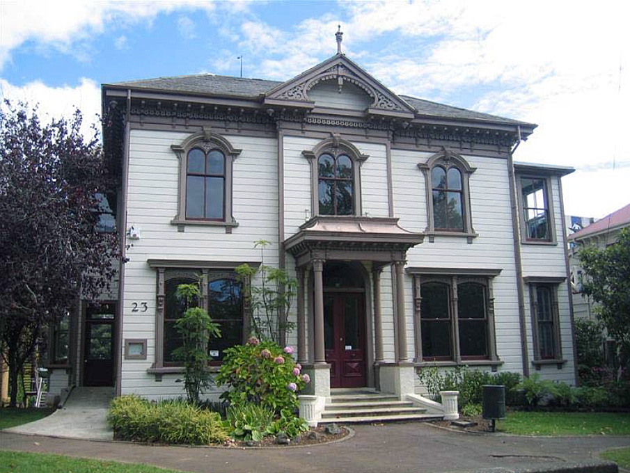
Early history of the site The site occupied by Sonoma was part of a significant Maori and early colonial landscape on the Symonds Street ridge. Prior to European arrival, land at the northern end of the ridge incorporated a pa known as Te Rerengaoraiti. Another settlement, Horotiu, may also have been located in the immediate vicinity, occupying high ground overlooking the Horotiu (now Queen Street) gully. Ongoing cultivations on the ridge were intermittently maintained during inter-tribal hostilities in the early nineteenth century and re-established by Ngati Whatua in the late 1830s. These were abandoned shortly before the Crown purchase of 3,000 acres at Auckland in 1841 to accommodate a capital for the new British colony. Following the establishment of Auckland as a colonial settlement, the Symonds Street ridge was at the epicentre of British administrative and military power in New Zealand. Significant buildings in the area included the Colonial Governor's residence at Government House, the Provincial Council and General Assembly, and the Albert Barracks - which was the largest military installation in the colony. Erected using Maori labour in 1846-1852, the basalt walls of the Barracks enclosed accommodation for approximately 1000 soldiers. The northern wall and structures associated with the fortification lay a short distance to the south of the current site of 21 Princes Street, with a military road running immediately beneath the property. This formed the primary access to the Barracks, linking its main gate with the southern terminus of Princes Street until 1873. Following the relocation of the colonial capital and its associated administration to Wellington in 1865, many of the troops were withdrawn. In February 1870, the last of the fourteen British regiments to serve in New Zealand left the Barracks, after which the fortification was decommissioned. Redevelopment of the Albert Barracks Reserve Decommissioning enabled a large part of the eastern core of colonial Auckland to be redeveloped. Prior to the construction of the Barracks, the Surveyor-General Felton Mathew had intended that the northern end of the Symonds Street ridge should be occupied by residences arranged in fashionable avenues and crescents. In the 1870s, the area remained desirable for its proximity to places of high social standing such as the former Government House, and for its elevated vantage point overlooking Auckland's commercial district. The Auckland Improvement Commission subsequently laid out new roads, subdivided the land and promoted the creation of Albert Park. The redevelopment appears to have marked a new approach in urban Auckland, consciously creating a neighbourhood based on wealth. Formal restrictions for leaseholders stipulated that sections could not be further subdivided and that the houses erected were to be two storied, roofed with slate or iron and to be built at a cost of at least £700. Plans for the houses were also subject to the approval of the commissioners. Earlier residential areas in Auckland were generally more mixed and influenced by shared places of work (such as occupation of the Symonds Street ridge by high officials and ordinary soldiers alike), although some areas were traditionally more prestigious than others. The redevelopment attracted many wealthy merchants, who had become Auckland's new elite following the departure of government officials to Wellington. The former were often self-made men from working- or lower middle-class backgrounds, whose success reflected the unusually high potential for social mobility in colonial New Zealand. Their rise was assisted by a prolonged economic boom in the 1870s and Auckland's emerging role as a major Pacific entrepot. As part of the redevelopment, tenders for the southward extension of Princes Street from its junction with Waterloo Quadrant were received in June 1873. The road, along with others in the vicinity, was evidently complete by April 1875. Most of the Barracks wall was also dismantled in 1873-1875. In keeping with the proposed nature of the area, the streets were metalled, lit with gas and provided with drainage and sewerage. Deciduous trees were also intended to be planted. In December 1875, the Auckland Improvement Commissioners auctioned 99-year leases for fourteen sites on the western side of Princes Street. Considered to be the premier plots within the redevelopment, these were advertised as desirable for their 'unsurpassed and uninterrupted view' over the surrounding area and their proximity to the Government House grounds. They were also considered suitable as villa sites for businessmen as they lay just a few minutes walk away from Auckland's main commercial district in the Queen Street gully. All of the purchasers obtained at least two conjoining allotments between 1875 and 1877 to provide generous sites for their homes. Construction and initial use of 21 Princes Street The lease for Lots 3 and 4 was purchased in December 1875 by chemist James Sharland (1819-1887). Sharland had set up in business as a chemist, druggist and general merchant in Taranaki in 1847, and is said to have brought the first recorded supply of drugs to New Zealand. Also New Plymouth's representative on the Provincial Council from 1857-1861 and from 1864-1866, Sharland relocated to Auckland in 1866 or 1867, purchasing the chemical business of J.N. Manning. His enterprise outgrew premises in the Queen Street area, necessitating the construction of a new commercial building in Kitchener and Lorne Streets. This lay close to the Princes Street site, near the bottom of Barracks Hill. Sharland appears to have erected a large timber house on Lots 3 and 4 in 1877-1878. Used from the outset as a family home, its designer and builder are not known. The two-storey weatherboard villa was of restrained Italianate design, with a symmetrical flat front and single-storey verandah. Italianate architecture was often used for mercantile premises and residences in Auckland during the late Victorian period, being modelled on the designs of Italian Renaissance buildings erected from the proceeds of commercial wealth. Internally, the building incorporated a large central hall, which evidently extended from front to back. Flanking rooms may have included a parlour and another large room on its northern side, and a dining room and service rooms on its southern side. Separate staircases in the hall led to both the upstairs area and a small basement in the rear part of the building. The upstairs contained several bedrooms accessed from a short central hall. It also appears to have included a small room, possibly a dressing room or bathroom, between the two front upstairs rooms. A timber extension at the rear that was present in 1882 may have been part of the structure from the outset. No outbuildings in the rear yard of the property appear in early plans. In 1878 Sharland published his Settlers' Guide and Household Companion, the foreword of which was written at his home in Princes Street. His publication was compiled with the intention of assisting families and those beyond the reach of medical aid and offered advice as to personal hygiene, rest, diet and exercise. Sharland became a household brand, his products sold throughout the country. He is known to have had close connections with medical practitioners who soon moved into the Princes Street area, perhaps encouraged by the presence of wealthy patrons and contemporary notions linking good health with open space and clean air. Sharland's near-neighbour, Dr Charles Haines, at 25-27 Princes Street, was his personal physician and also occupied rooms above his commercial premises. Sharland was still the occupant of the dwelling in 1884-85, when Auckland's main synagogue was erected next door at 19A Princes Street. Sharland's first wife, Alice, had died in 1878 and he subsequently remarried Louisa, the sister of Philip Philips. For 25 years the president, secretary and treasurer of Auckland's Hebrew congregation, Philips had played an instrumental role in securing construction of the synagogue on the Symonds Street ridge. He had also been instrumental in having the Albert Barracks site vested in the Auckland Improvement Commission during his time as mayor of Auckland (1871-1874). Following Sharland's death in 1887 until 1890, Philips lived in the house with his sister Louisa. During this period, he continued to play an influential role in local government as town clerk, a post that he held from 1874 to 1899. Philips can be considered Auckland's most prominent local government officer during the late colonial period. Subsequent use and modification Although its leasehold remained with Louisa Sharland until 1920, the house was sublet to the manager of the Union Bank of Australia, Alexander Thompson, in 1890. The residence acquired new occupants in 1893 when it became a boarding house, known as Sonoma, run by William Cruickshank. This occurred during a period of economic depression when large houses in the area were increasingly used for this purpose. Cruickshank's premises were unusual in being owned by a man rather than a single woman of good repute. In the late nineteenth and early twentieth centuries, wealthy families increasingly moved to residences in Auckland's suburbs. Documentary evidence indicates that by 1903 a new addition had replaced the earlier rear extension, and a corrugated iron lean-to on the northern side was also in place. The allotment may have been slightly extended in its northwest corner to accommodate a flight of pedestrian steps leading into the yard from a service lane to the rear. The grounds were separated into a front garden, a service yard incorporating washing facilities and toilets, and a rear garden containing what may have been fruit trees and a vegetable plot. Tall timber fences appear to have divided these elements from each other. At about this time or earlier, the name 'Ellesmere' was transferred from an adjacent boarding house at 23 Princes Street. By 1922, the house had been partitioned. Local street directories record the premises as being in apartments in 1925, a use that continued into the 1950s. In 1947 the building had fifteen or sixteen bedrooms, two kitchens and three bathrooms. Institutional use and heritage protection By 1954 the building was occupied by the Auckland University College as an Adult Education Centre. Occupying the neighbourhood from the late nineteenth century, the University College (now University of Auckland) expanded its premises during the early and mid 1900s following a decision to maintain activities on a central city site, on the basis that working people could more easily attend. Defective building materials were replaced and extra toilets constructed to accommodate the new use. Over the following twenty years the building had a large number of tenants. The Municipal Arts Trust was the occupier of the building in 1975 and completed fire-rating work by the following year. By the 1970s, the land on which the house stood had reverted to Auckland City Council ownership following the expiry of its 99-year lease. In 1963 the Council had decided that Sonoma, along with its neighbours on the western side of Princes Street should be demolished to become part of Albert Park. By 1972 a developing awareness of the importance of preserving heritage, and heritage values in formal city plans, led the Auckland City Council to retain and restore the Victorian residences. The Auckland Improvement Trust Act 1971 allowed the Council to keep one or more of the houses as examples of Victorian architecture, and a subsequent Act detailed how the buildings were to be managed. In 1974 the Council resolved to designate the houses and the adjacent synagogue as a conservation area and to restore them. Physical boundaries separating the property from the adjoining house to the south appear to have been removed at this time or later. The building was renovated in 1989 to provide for a day care centre for pre-school children, its current use. French doors were installed opening onto a single-storey verandah addition at ground floor level. An additional staircase was provided as well as further toilets. A playground has also been created in its rear yard. Sonoma is one of very few elite dwellings remaining from when the Symonds Street ridge was the premier residential address in the city. Many contemporary houses that occupied neighbouring streets have been demolished, and of those that remain most have lost significant aspects of their nineteenth-century surroundings, including their curtilages. Together with Albert Park and other houses that remain on the western side of Princes Street, Sonoma forms an important reminder of a major recreational and residential landscape on the fringe of Auckland's colonial commercial district.
Early history of the site The site occupied by Sonoma was part of a significant Maori and early colonial landscape on the Symonds Street ridge. Prior to European arrival, land at the northern end of the ridge incorporated a pa known as Te Rerengaoraiti. Another settlement, Horotiu, may also have been located in the immediate vicinity, occupying high ground overlooking the Horotiu (now Queen Street) gully. Ongoing cultivations on the ridge were intermittently maintained during inter-tribal hostilities in the early nineteenth century and re-established by Ngati Whatua in the late 1830s. These were abandoned shortly before the Crown purchase of 3,000 acres at Auckland in 1841 to accommodate a capital for the new British colony. Following the establishment of Auckland as a colonial settlement, the Symonds Street ridge was at the epicentre of British administrative and military power in New Zealand. Significant buildings in the area included the Colonial Governor's residence at Government House, the Provincial Council and General Assembly, and the Albert Barracks - which was the largest military installation in the colony. Erected using Maori labour in 1846-1852, the basalt walls of the Barracks enclosed accommodation for approximately 1000 soldiers. The northern wall and structures associated with the fortification lay a short distance to the south of the current site of 21 Princes Street, with a military road running immediately beneath the property. This formed the primary access to the Barracks, linking its main gate with the southern terminus of Princes Street until 1873. Following the relocation of the colonial capital and its associated administration to Wellington in 1865, many of the troops were withdrawn. In February 1870, the last of the fourteen British regiments to serve in New Zealand left the Barracks, after which the fortification was decommissioned. Redevelopment of the Albert Barracks Reserve Decommissioning enabled a large part of the eastern core of colonial Auckland to be redeveloped. Prior to the construction of the Barracks, the Surveyor-General Felton Mathew had intended that the northern end of the Symonds Street ridge should be occupied by residences arranged in fashionable avenues and crescents. In the 1870s, the area remained desirable for its proximity to places of high social standing such as the former Government House, and for its elevated vantage point overlooking Auckland's commercial district. The Auckland Improvement Commission subsequently laid out new roads, subdivided the land and promoted the creation of Albert Park. The redevelopment appears to have marked a new approach in urban Auckland, consciously creating a neighbourhood based on wealth. Formal restrictions for leaseholders stipulated that sections could not be further subdivided and that the houses erected were to be two storied, roofed with slate or iron and to be built at a cost of at least £700. Plans for the houses were also subject to the approval of the commissioners. Earlier residential areas in Auckland were generally more mixed and influenced by shared places of work (such as occupation of the Symonds Street ridge by high officials and ordinary soldiers alike), although some areas were traditionally more prestigious than others. The redevelopment attracted many wealthy merchants, who had become Auckland's new elite following the departure of government officials to Wellington. The former were often self-made men from working- or lower middle-class backgrounds, whose success reflected the unusually high potential for social mobility in colonial New Zealand. Their rise was assisted by a prolonged economic boom in the 1870s and Auckland's emerging role as a major Pacific entrepot. As part of the redevelopment, tenders for the southward extension of Princes Street from its junction with Waterloo Quadrant were received in June 1873. The road, along with others in the vicinity, was evidently complete by April 1875. Most of the Barracks wall was also dismantled in 1873-1875. In keeping with the proposed nature of the area, the streets were metalled, lit with gas and provided with drainage and sewerage. Deciduous trees were also intended to be planted. In December 1875, the Auckland Improvement Commissioners auctioned 99-year leases for fourteen sites on the western side of Princes Street. Considered to be the premier plots within the redevelopment, these were advertised as desirable for their 'unsurpassed and uninterrupted view' over the surrounding area and their proximity to the Government House grounds. They were also considered suitable as villa sites for businessmen as they lay just a few minutes walk away from Auckland's main commercial district in the Queen Street gully. All of the purchasers obtained at least two conjoining allotments between 1875 and 1877 to provide generous sites for their homes. Construction and initial use of 21 Princes Street The lease for Lots 3 and 4 was purchased in December 1875 by chemist James Sharland (1819-1887). Sharland had set up in business as a chemist, druggist and general merchant in Taranaki in 1847, and is said to have brought the first recorded supply of drugs to New Zealand. Also New Plymouth's representative on the Provincial Council from 1857-1861 and from 1864-1866, Sharland relocated to Auckland in 1866 or 1867, purchasing the chemical business of J.N. Manning. His enterprise outgrew premises in the Queen Street area, necessitating the construction of a new commercial building in Kitchener and Lorne Streets. This lay close to the Princes Street site, near the bottom of Barracks Hill. Sharland appears to have erected a large timber house on Lots 3 and 4 in 1877-1878. Used from the outset as a family home, its designer and builder are not known. The two-storey weatherboard villa was of restrained Italianate design, with a symmetrical flat front and single-storey verandah. Italianate architecture was often used for mercantile premises and residences in Auckland during the late Victorian period, being modelled on the designs of Italian Renaissance buildings erected from the proceeds of commercial wealth. Internally, the building incorporated a large central hall, which evidently extended from front to back. Flanking rooms may have included a parlour and another large room on its northern side, and a dining room and service rooms on its southern side. Separate staircases in the hall led to both the upstairs area and a small basement in the rear part of the building. The upstairs contained several bedrooms accessed from a short central hall. It also appears to have included a small room, possibly a dressing room or bathroom, between the two front upstairs rooms. A timber extension at the rear that was present in 1882 may have been part of the structure from the outset. No outbuildings in the rear yard of the property appear in early plans. In 1878 Sharland published his Settlers' Guide and Household Companion, the foreword of which was written at his home in Princes Street. His publication was compiled with the intention of assisting families and those beyond the reach of medical aid and offered advice as to personal hygiene, rest, diet and exercise. Sharland became a household brand, his products sold throughout the country. He is known to have had close connections with medical practitioners who soon moved into the Princes Street area, perhaps encouraged by the presence of wealthy patrons and contemporary notions linking good health with open space and clean air. Sharland's near-neighbour, Dr Charles Haines, at 25-27 Princes Street, was his personal physician and also occupied rooms above his commercial premises. Sharland was still the occupant of the dwelling in 1884-85, when Auckland's main synagogue was erected next door at 19A Princes Street. Sharland's first wife, Alice, had died in 1878 and he subsequently remarried Louisa, the sister of Philip Philips. For 25 years the president, secretary and treasurer of Auckland's Hebrew congregation, Philips had played an instrumental role in securing construction of the synagogue on the Symonds Street ridge. He had also been instrumental in having the Albert Barracks site vested in the Auckland Improvement Commission during his time as mayor of Auckland (1871-1874). Following Sharland's death in 1887 until 1890, Philips lived in the house with his sister Louisa. During this period, he continued to play an influential role in local government as town clerk, a post that he held from 1874 to 1899. Philips can be considered Auckland's most prominent local government officer during the late colonial period. Subsequent use and modification Although its leasehold remained with Louisa Sharland until 1920, the house was sublet to the manager of the Union Bank of Australia, Alexander Thompson, in 1890. The residence acquired new occupants in 1893 when it became a boarding house, known as Sonoma, run by William Cruickshank. This occurred during a period of economic depression when large houses in the area were increasingly used for this purpose. Cruickshank's premises were unusual in being owned by a man rather than a single woman of good repute. In the late nineteenth and early twentieth centuries, wealthy families increasingly moved to residences in Auckland's suburbs. Documentary evidence indicates that by 1903 a new addition had replaced the earlier rear extension, and a corrugated iron lean-to on the northern side was also in place. The allotment may have been slightly extended in its northwest corner to accommodate a flight of pedestrian steps leading into the yard from a service lane to the rear. The grounds were separated into a front garden, a service yard incorporating washing facilities and toilets, and a rear garden containing what may have been fruit trees and a vegetable plot. Tall timber fences appear to have divided these elements from each other. At about this time or earlier, the name 'Ellesmere' was transferred from an adjacent boarding house at 23 Princes Street. By 1922, the house had been partitioned. Local street directories record the premises as being in apartments in 1925, a use that continued into the 1950s. In 1947 the building had fifteen or sixteen bedrooms, two kitchens and three bathrooms. Institutional use and heritage protection By 1954 the building was occupied by the Auckland University College as an Adult Education Centre. Occupying the neighbourhood from the late nineteenth century, the University College (now University of Auckland) expanded its premises during the early and mid 1900s following a decision to maintain activities on a central city site, on the basis that working people could more easily attend. Defective building materials were replaced and extra toilets constructed to accommodate the new use. Over the following twenty years the building had a large number of tenants. The Municipal Arts Trust was the occupier of the building in 1975 and completed fire-rating work by the following year. By the 1970s, the land on which the house stood had reverted to Auckland City Council ownership following the expiry of its 99-year lease. In 1963 the Council had decided that Sonoma, along with its neighbours on the western side of Princes Street should be demolished to become part of Albert Park. By 1972 a developing awareness of the importance of preserving heritage, and heritage values in formal city plans, led the Auckland City Council to retain and restore the Victorian residences. The Auckland Improvement Trust Act 1971 allowed the Council to keep one or more of the houses as examples of Victorian architecture, and a subsequent Act detailed how the buildings were to be managed. In 1974 the Council resolved to designate the houses and the adjacent synagogue as a conservation area and to restore them. Physical boundaries separating the property from the adjoining house to the south appear to have been removed at this time or later. The building was renovated in 1989 to provide for a day care centre for pre-school children, its current use. French doors were installed opening onto a single-storey verandah addition at ground floor level. An additional staircase was provided as well as further toilets. A playground has also been created in its rear yard. Sonoma is one of very few elite dwellings remaining from when the Symonds Street ridge was the premier residential address in the city. Many contemporary houses that occupied neighbouring streets have been demolished, and of those that remain most have lost significant aspects of their nineteenth-century surroundings, including their curtilages. Together with Albert Park and other houses that remain on the western side of Princes Street, Sonoma forms an important reminder of a major recreational and residential landscape on the fringe of Auckland's colonial commercial district.
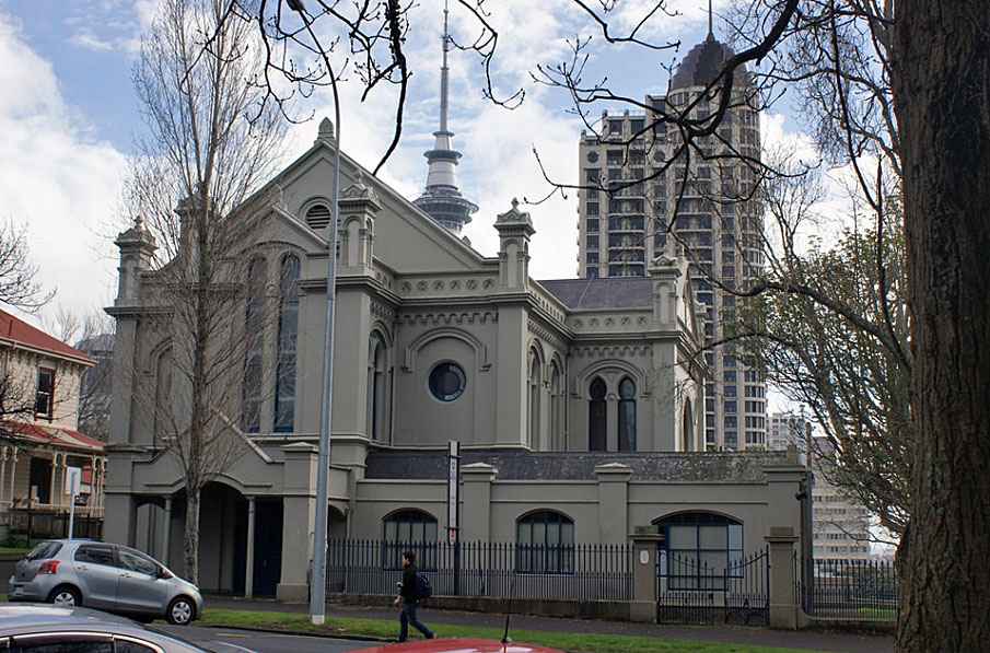
Context Sonoma is located in the eastern part of Auckland's Central Business District (CBD), on the Symonds Street ridge. It is situated on the western side of Princes Street, a broad tree-lined thoroughfare that separates the city campus of the University of Auckland from Albert Park, one of central Auckland's main recreational spaces. Sonoma is one of five large adjoining historic residences along the eastern fringe of the park. A narrow service access, Bowen Lane, separates most of these properties from the park grounds. The immediate area is noted for its historical and cultural heritage significance, encompassing numerous important buildings and archaeological sites. Immediately to the north of the Princes Street residences is the former Synagogue (NZHPT Registration # 578, Category I historic place), and the elite Northern Club (NZHPT Registration # 663, Category I historic place). To the east are the former Government House and its grounds (NZHPT Registration # 105, Category I historic place), the University of Auckland Old Arts Building (NZHPT Registration # 25, Category I historic place), and a remnant of the Albert Barracks Wall (NZHPT Registration # 12, Category I historic place). To the south and west, Albert Park is also an important archaeological and historical landscape, incorporating the buried remains of the Albert Barracks, several registered historic places (including a band rotunda and a keeper's cottage), and other elements linked with nineteenth-century recreational and Second World War military use. Sonoma is the northernmost of a group of five surviving nineteenth- and early twentieth-century residences, and occupies a 1125 m² rectangular lot. The site initially slopes gently to the west from Princes Street, but then falls away more steeply towards the western boundary. The north boundary is retained by masonry walls. The property incorporates a large two-storey building, a comparatively flat front garden with broad paths and small trees, and a children's playground to the side and rear. The front yard is grassed and separated from the street by a low ashlar wall. The west (rear) boundary is retained by an aggregate-faced concrete slab wall (1979), at the north end of which is an older flight of steps (late nineteenth or early twentieth century) that provide access from Bowen Lane. The property's south boundary is unfenced. The site may incorporate the remains of a military road that connected the main gate of Albert Barracks with the original southern terminus of Princes Street prior to 1873. It may also contain buried remains associated with the later residential use of the place. Nearby excavations at 31 Princes Street in 1990 revealed the well-preserved remains of features connected with both phases. Exterior The main building is of timber and is comparatively simple in design. Its overall style is Italianate, incorporating front and side verandahs, a shallow-hipped corrugated iron roof and wide bracketed eaves. Timber weatherboards are rusticated. The structure encompasses an original two-storey section of rectangular plan with two small lean-to additions. A more sizeable timber extension incorporating a basement projects westwards to the rear. The building largely retains its nineteenth-century appearance from Princes Street and Bowen Lane. The front (east) elevation facing Princes Street is of symmetrical design. A single-storey verandah runs the length of the ground floor, sheltering the centrally located front door and two flanking bay widows. Detailing includes Corinthian pilasters. Five double-hung sash windows light the upper storey. The other facades are less ornate but have some similar features. On the ground floor a recent verandah addition extends along most of the northern side wall and part of the western elevation of the original house. On the south elevation the upper sections of some sash windows at ground floor level have been replaced by louvres, and a door and window associated with a modern fire stair are relatively recent. The rear wing has a gabled roof with decorative bargeboards, plain fixed windows in its south and west elevations, and doors in the north elevation. Interior The building interior retains much of its nineteenth-century layout and detailing, although some alterations have been made including the removal of fireplaces and chimneybreasts. The ground floor incorporates a wide central hall with a staircase to the upper level, and has large rooms on its north side and at the front on its south side. Smaller rooms are located on the south side further west, include recent secondary stairs to the first floor. A door at the rear of the hall leads into the upper floor of the rear extension, which contains a single large room. Steps at the back of the main hall provide access into the basement of the main structure, in which are four windowless rooms. The stairs also lead to the downstairs level of the extension which holds a single room of confined height. The first floor of the main residence contains several rooms accessed from a small central hall. A secondary corridor leads to toilets and other facilities at the rear. The main ground floor entrance hall has board and batten ceilings, and a staircase with an elegant balustrade. The staircase is timber panelled in its understair portion. The front room on the south side of the hall includes a bay window with panelling below. Board and batten ceilings are also preserved in rooms on this side of the hall. A probable fireplace in the wall partitioning the rooms on this side has been removed. Skirtings, architraves and doors have generally been preserved. Such elements also generally survive at first floor level, as have board and batten ceilings.
Context Sonoma is located in the eastern part of Auckland's Central Business District (CBD), on the Symonds Street ridge. It is situated on the western side of Princes Street, a broad tree-lined thoroughfare that separates the city campus of the University of Auckland from Albert Park, one of central Auckland's main recreational spaces. Sonoma is one of five large adjoining historic residences along the eastern fringe of the park. A narrow service access, Bowen Lane, separates most of these properties from the park grounds. The immediate area is noted for its historical and cultural heritage significance, encompassing numerous important buildings and archaeological sites. Immediately to the north of the Princes Street residences is the former Synagogue (NZHPT Registration # 578, Category I historic place), and the elite Northern Club (NZHPT Registration # 663, Category I historic place). To the east are the former Government House and its grounds (NZHPT Registration # 105, Category I historic place), the University of Auckland Old Arts Building (NZHPT Registration # 25, Category I historic place), and a remnant of the Albert Barracks Wall (NZHPT Registration # 12, Category I historic place). To the south and west, Albert Park is also an important archaeological and historical landscape, incorporating the buried remains of the Albert Barracks, several registered historic places (including a band rotunda and a keeper's cottage), and other elements linked with nineteenth-century recreational and Second World War military use. Sonoma is the northernmost of a group of five surviving nineteenth- and early twentieth-century residences, and occupies a 1125 m² rectangular lot. The site initially slopes gently to the west from Princes Street, but then falls away more steeply towards the western boundary. The north boundary is retained by masonry walls. The property incorporates a large two-storey building, a comparatively flat front garden with broad paths and small trees, and a children's playground to the side and rear. The front yard is grassed and separated from the street by a low ashlar wall. The west (rear) boundary is retained by an aggregate-faced concrete slab wall (1979), at the north end of which is an older flight of steps (late nineteenth or early twentieth century) that provide access from Bowen Lane. The property's south boundary is unfenced. The site may incorporate the remains of a military road that connected the main gate of Albert Barracks with the original southern terminus of Princes Street prior to 1873. It may also contain buried remains associated with the later residential use of the place. Nearby excavations at 31 Princes Street in 1990 revealed the well-preserved remains of features connected with both phases. Exterior The main building is of timber and is comparatively simple in design. Its overall style is Italianate, incorporating front and side verandahs, a shallow-hipped corrugated iron roof and wide bracketed eaves. Timber weatherboards are rusticated. The structure encompasses an original two-storey section of rectangular plan with two small lean-to additions. A more sizeable timber extension incorporating a basement projects westwards to the rear. The building largely retains its nineteenth-century appearance from Princes Street and Bowen Lane. The front (east) elevation facing Princes Street is of symmetrical design. A single-storey verandah runs the length of the ground floor, sheltering the centrally located front door and two flanking bay widows. Detailing includes Corinthian pilasters. Five double-hung sash windows light the upper storey. The other facades are less ornate but have some similar features. On the ground floor a recent verandah addition extends along most of the northern side wall and part of the western elevation of the original house. On the south elevation the upper sections of some sash windows at ground floor level have been replaced by louvres, and a door and window associated with a modern fire stair are relatively recent. The rear wing has a gabled roof with decorative bargeboards, plain fixed windows in its south and west elevations, and doors in the north elevation. Interior The building interior retains much of its nineteenth-century layout and detailing, although some alterations have been made including the removal of fireplaces and chimneybreasts. The ground floor incorporates a wide central hall with a staircase to the upper level, and has large rooms on its north side and at the front on its south side. Smaller rooms are located on the south side further west, include recent secondary stairs to the first floor. A door at the rear of the hall leads into the upper floor of the rear extension, which contains a single large room. Steps at the back of the main hall provide access into the basement of the main structure, in which are four windowless rooms. The stairs also lead to the downstairs level of the extension which holds a single room of confined height. The first floor of the main residence contains several rooms accessed from a small central hall. A secondary corridor leads to toilets and other facilities at the rear. The main ground floor entrance hall has board and batten ceilings, and a staircase with an elegant balustrade. The staircase is timber panelled in its understair portion. The front room on the south side of the hall includes a bay window with panelling below. Board and batten ceilings are also preserved in rooms on this side of the hall. A probable fireplace in the wall partitioning the rooms on this side has been removed. Skirtings, architraves and doors have generally been preserved. Such elements also generally survive at first floor level, as have board and batten ceilings.
Historical and Associated Iwi / Hapū / Whānau
Public NZAA Number
R11/833
Completion Date
8th November 2007
Report Written By
Martin Jones
Information Sources
Cyclopedia of New Zealand, 1902
Cyclopedia Company, Industrial, descriptive, historical, biographical facts, figures, illustrations, Wellington, N.Z, 1897-1908, Vol.2, Christchurch, 1902
Easdale, 1980
N. Easdale, Five Gentlemen's Residences in Princes Street Auckland: The Occupants and Their Enterprises 1875-1900, Auckland, 1980
Southern Cross
Southern Cross
Stone, 1973
R. C. J. Stone, Makers of Fortune: A Colonial Business Community and its Fall, Auckland, 1973
Other Information
Management of the place is governed by the Auckland Improvement Trust Amendment Act 1973. Section 4 of the Act provides constraints on use and modification. Please note that entry on the New Zealand Heritage List/Rarangi Korero identifies only the heritage values of the property concerned, and should not be construed as advice on the state of the property, or as a comment of its soundness or safety, including in regard to earthquake risk, safety in the event of fire, or insanitary conditions.
Current Usages
Uses: Education
Specific Usage: Pre-school education
Former Usages
General Usage: Accommodation
Specific Usage: Boarding/ Guest House
General Usage: Accommodation
Specific Usage: Complex of flats
General Usage: Accommodation
Specific Usage: House
General Usage: Education
Specific Usage: Adult Education/training
General Usage: Trade
Specific Usage: Office building/Offices
Location
Related listings
Sign up to hear more
Get the latest heritage news, features and events delivered
straight to your inbox.
