

Its date of construction is believed to be between 1843 and 1851. It is clearly shown in a drawing made by John Jolliffe, surgeon on HMS Pandora, in October 1851. It is not shown on a sketch plan drawn in December 1842.
The stone blocks from which the bridge is constructed are made from Sydney sandstone. They are said to have been brought to the Hokianga as ballast in empty timber export ships returning from Sydney to collect further cargo. The name of the builder of the bridge is not known.
Reclamation of the harbour, in large part a result of the activities of the adjacent former Kohukohu timber mill, which began operations in 1879, means that the bridge is no longer at the harbour's edge, and no longer serves as a through route.
List Entry Information
Status
Listed
List Entry Status
Historic Place Category 1
Access
Private/No Public Access
List Number
7741
Date Entered
4th April 2008
Date of Effect
4th April 2008
City/District Council
Far North District
Region
Northland Region
Extent of List Entry
Registration includes part of the land described as Sec 57 and Pt Lot 2 DP 23934, Blk X Mangamuka SD, North Auckland Land District, and the structure known as Stone Bridge, Kohukohu thereon. It includes those parts of the bridge that are currently under the soil. (Refer to Extent of Registration Map in Appendix 1 of the Registration Report for further information).
Legal description
Sec 57 (NZ Gazette 1977, p.397) and Pt Lot 2 DP 23934, Blk X Mangamuka SD (NZ Gazette 1981, p.1917), North Auckland Land District.
Location Description
The bridge crosses the Waihouuru Creek between Kohukohu School and the Kohukohu Bowling Club green.
Why is this place significant?
Historic Significance
Historical Significance or Value As the oldest surviving bridge in New Zealand and the oldest stone arch bridge, this bridge has outstanding historical value in the history of New Zealand.
Physical Significance
ARCHAEOLOGICAL SIGNIFICANCE OR VALUE: The approaches to the bridge on each side have been buried as a result of reclamation and development of the adjacent land. It is clear that much of the original bridge is now under the surface, presenting a significant opportunity for archaeological investigation of both the extant portion of the bridge and its buried approaches. TECHNOLOGICAL SIGNIFICANCE OR VALUE: As the oldest surviving bridge in New Zealand and the oldest stone arch bridge, this bridge has outstanding technological value in the history of engineering and public works in New Zealand
Why is this place Category 1 / Category 2?
Detail Of Assessed Criteria
a) The extent to which the place reflects important or representative aspects of New Zealand history The development, design and construction of bridges to cross New Zealand's many rivers, creeks and swamps was essential to its whole land transport infra-structure. Although modest in size and scale, this bridge, as the oldest surviv-ing bridge and the oldest stone arch bridge is an icon of outstanding signifi-cance representing the importance of bridges in the past and currently to New Zealand's development as a modern nation. (g) The technical accomplishment or value, or design of the place The stone arch bridge is a considerable technical accomplishment. Its use in New Zealand has been less common, something attributed to a relative lack of suitable stone, a shortage of masons, the limitations of the short spans attain-able in a country with wide rivers and swamps to be crossed, and the relatively higher cost because of the ready availability of timber in New Zealand. As an example of bridge technology, and one that remains standing over 150 years after it was built, this bridge represents an outstanding technological accomplishment. (i) The importance of identifying historic places known to date from early periods of New Zealand settlement The Hokianga harbour was one of the earliest focal points for Pakeha settlement in New Zealand, and together with the Bay of Islands contains a number of places dating from the earliest periods of interaction between Maori and Pakeha. As the oldest bridge in New Zealand, this bridge represents an outstanding example of a place relating to the early Pakeha settlement of Hokianga and New Zealand. (j) The importance of identifying rare types of historic places As the oldest surviving bridge in New Zealand and the first known stone arch bridge, this bridge is unique. Summary of Significance or Values This place was assessed against, and found it to qualify under the following criteria: a, g, i, j. Conclusion In several aspects of this assessment, this bridge has been assessed as having 'outstanding' significance. It is unique, it is the oldest surviving bridge in New Zealand and was the first known bridge of its type to be built. It takes on iconic, representative status, still standing after 150 years to represent all subsequent bridges that have been and remain so significant in the development of New Zealand as a modern nation. It is considered that this place qualifies as a Category I historic place.
Construction Details
Start Year
1839
Type
Other
Description
G F Russell purchases the land on the north bank of the Waihouuru Creek.
Start Year
1842
Type
Other
Description
A sketch map is produced in the Land Claims Court, which shows the creek but not the bridge.
Start Year
1851
Type
Other
Description
John Jolliffe, surgeon on HMS Pandora, draws the house of G F Russell Esq. at Kohukohu. His drawing shows the bridge.
Start Year
1879
Type
Other
Description
Timber mill began operations on land adjacent to the bridge.
Start Year
1912
Type
Other
Description
Timber mill demolished.
Start Year
1923
Type
Other
Description
New mill built on the site of the previous one.
Start Year
1937
Type
Other
Description
Mill burns down and is not replaced.
Start Year
1971
Type
Other
Description
New Kohukohu School built adjacent to the Stone Bridge.
Construction Materials
Sydney sandstone, reported to have been brought to the Hokianga as ballast in timber export ships returning in ballast to uplift further cargo.
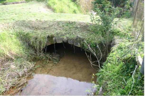
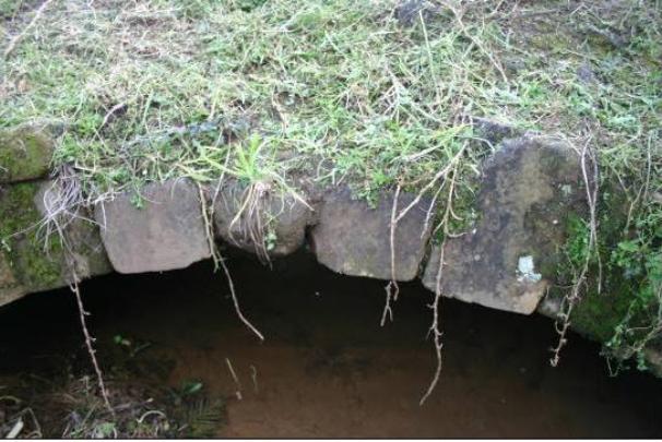
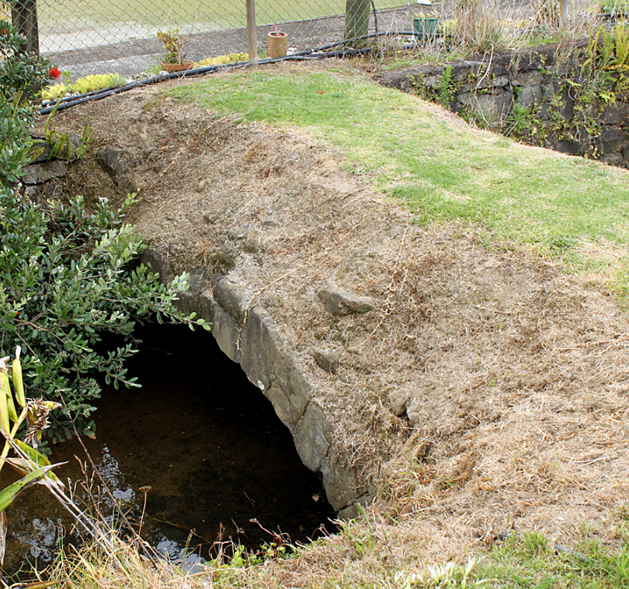
HISTORICAL DESCRIPTION AND ANALYSIS: This simple arched stone footbridge is one of the oldest stone bridges in New Zealand: it is thought to be the oldest stone arch bridge in New Zealand and the oldest surviving bridge in New Zealand. It was built at what was then the mouth of the Waihouuru Creek where it entered the Hokianga Harbour, and provided passage across the creek for people moving along the shoreline at Kohukohu. Geoffrey Thornton, authoritative historian of bridges in New Zealand and a former Board member of NZ Historic Places Trust, refers to the wooden bridge built over the Waitangi River near Waimate North in 1830 as New Zealand's first real bridge. He mentions bridges built in 1841 in New Plymouth, in Wellington in 1842 and in Auckland in 1843. All these were simple timber structures, and none of them survives. Following the passing of the New Zealand Constitution Act in 1852 and the establishment of provincial government, more substantial bridges began to be erected under the initiative of newly appointed Provincial Engineers. Some of these incorporated brick or stone abutments, and sometimes steel trusses. Thornton comments that stone arch bridges are relatively uncommon in New Zealand, a fact that he attributes to a lack of suitable stone, a shortage of masons, the limitations of the short spans attainable, the higher cost and the ready availability of timber in New Zealand. He has this to say about the Stone Bridge at Kohukohu: Claimed as the oldest extant bridge in New Zealand is the minuscule Sydney sandstone arch over a ditch like creek in the school grounds at Kohukohu in the Hokianga Harbour. It is restricted to foot traffic and may possibly have been built earlier than 1840. Thornton states that the oldest stone traffic bridge still in use was built in Oamaru in 1861. The date of construction of the bridge is not known. It is clearly shown in a drawing made by John Jolliffe, surgeon on HMS Pandora, in October 1851 . In his Journal for 10 October 1851, Jolliffe provided an enthusiastic and detailed description of the residence of George Russell, where the bridge is located. Went up the river this morning to a distance of about twenty-five miles, and made a sort of picnic of it, having our meals in the boat and cooking our own breakfast and dinner, called upon Mr Aubrey but he was not at home. We, however, stopped a few minutes to pay our respects to his wife and then went on to Mr Russell's place, which is by far the loveliest little spot I have seen in New Zealand. The house, outhouses and grounds around are all in perfect order and the very picture of neatness. The gardens and orchards are very well and prettily laid out, with plenty of English fruit trees and English flowers, particularly roses of several sorts which flourish famously, growing in high hedges and full of blossoms. Mr Russell is a contractor for large kauri pine spars for the Royal Navy. Jolliffe does not mention the bridge, so it may be assumed that it was not a new or novel element on the property in 1851. The first Pakeha to live at Kohukohu was David Clarke, who married two of the daughters of one of the local chiefs Wharepapa. Clarke drowned in 1831 before he could purchase the land, but in 1834 Kohukohu was bought by F. E. Maning from Wharepapa, Tarewarewa and others. Maning sold to Dr Ross, who sold to Rev. N. Turner, who sold to G. F. Russell in 1837. Ruth Ross, writing in the 1970s, noted that 'it is firmly believed in Kohukohu that the stone bridge over the Waihouuru creek was built in 1836. So far as I know no evidence in support of this belief has ever been put forward'. Ross analyses land ownership in the area in the 1830s, and concludes 'That either Maning or Smythe or any of the other rafferty residents of Kohukohu during the 1830s would have built the bridge seems to me the height of improbability. She refers to the purchase of the land by GF Russell in June 1839 and notes that the sketch map of Kohukohu presented in the Court of Land Claims in December 1842 or January or February 1843 shows a 'dock yard' (which she suggests was in fact a timber boom) across the bay the creek flows into, but does not show a bridge. Ruth Ross continues: Russell carried on his timber business at Kohukohu until his death in 1855. He is a possible bridge builder (some time between 1843 and 1855), and in my opinion the first possible bridge builder. But I have always thought it more likely that the Waihouuru bridge was built by his son-in-law, John Webster. Webster took over the Kohukohu business after Russell's death in 1855. Jolliffe's drawing, which Ross did not know, clearly indicates that the bridge existed during Russell's lifetime. Her original suggestion that G F Russell was the person for whom the bridge was built, some time between 1843 and 1851 (rather than 1855) would seem to have been correct. In a Statement of Claim in support of his Land Claim dated Hokianga 12 December 1842, G F Russell describes the land subject to his claim: I claim the Land described in the Deed now before the Court, situated on the Western bank of the Hokianga River, being part of the Kohu Kohu containing about 50 acres. It is bounded as follows: 'From the Creek called Waihouuru being the boundary of the land accepted by Messrs Smythe & Newton a line running west by compass constitutes the southern boundary of the said land. A line running from the forenamed Creek along the left hand Bank of the Main River as far as a Puridi [Puriri?] Tree marked thus ///// is to constitute the Eastern Boundary...' I have expended in Buildings and Improvements on this Property about ₤3,000... Since the bridge is situated at what was one corner of this land, it seems highly likely that Russell would have referred to it as a boundary marker, in the same way that he refers to the Puriri tree, if it had been built by this date. It seems very likely therefore that the bridge was built after December 1842. The bridge was quite a substantial structure. However, because its approaches have been covered by the encroachment of the surrounding land and because of the reclamation of the harbour and silting up of the creek, it appears less substantial now that it was originally. Wheeled traffic was a rarity in the Hokianga well into the twentieth century, and the bridge was perfectly adequate for the pedestrian and later equestrian traffic for which it was built. The path running across it shown in the Yarborough photograph (Appendix 2, Plate 2) certainly suggests that two people could pass abreast on the bridge. All the factors Thornton enunciates to explain the small number of stone arch bridges in New Zealand come into play in explaining why this bridge was built in stone. Because of the importing of Sydney sandstone as ballast, stone was in plentiful supply in Kohukohu at this time - it was used in other walling and construction projects in the town as well. While it is not known who the mason or masons were, the regular trade with Sydney and the substantial employment opportunities in the Hokianga make it likely there were trained masons available. Former convict William Parrott had come across from Sydney and built the Stone Store in Kerikeri between 1832 and 1834, and it is likely there were other similarly skilled immigrants in the Hokianga at this period. Because the creek was small, only a short span was required. Because of the ready supply of free stone, cost was unlikely to be a significant consideration, and although timber was readily available, it was more valuable as an export product. Geoffrey Thornton has commented recently: With a date between 1843 and 1851 it is reasonable to claim the Kohukohu stone bridge as oldest surviving bridge in New Zealand and this warrants Category 1. It is also the oldest stone arch bridge and lack of size is not particularly relevant. It has to be remembered that bridges were the most important elements in the nation's infrastructure in opening up the country for settlement, industry and social development. The stone blocks from which the bridge is constructed are made from Sydney sandstone. They are said to have been brought to the Hokianga as ballast in empty timber export ships returning from Sydney to collect further cargo. The name of the actual builder of the bridge is not known.
HISTORICAL DESCRIPTION AND ANALYSIS: This simple arched stone footbridge is one of the oldest stone bridges in New Zealand: it is thought to be the oldest stone arch bridge in New Zealand and the oldest surviving bridge in New Zealand. It was built at what was then the mouth of the Waihouuru Creek where it entered the Hokianga Harbour, and provided passage across the creek for people moving along the shoreline at Kohukohu. Geoffrey Thornton, authoritative historian of bridges in New Zealand and a former Board member of NZ Historic Places Trust, refers to the wooden bridge built over the Waitangi River near Waimate North in 1830 as New Zealand's first real bridge. He mentions bridges built in 1841 in New Plymouth, in Wellington in 1842 and in Auckland in 1843. All these were simple timber structures, and none of them survives. Following the passing of the New Zealand Constitution Act in 1852 and the establishment of provincial government, more substantial bridges began to be erected under the initiative of newly appointed Provincial Engineers. Some of these incorporated brick or stone abutments, and sometimes steel trusses. Thornton comments that stone arch bridges are relatively uncommon in New Zealand, a fact that he attributes to a lack of suitable stone, a shortage of masons, the limitations of the short spans attainable, the higher cost and the ready availability of timber in New Zealand. He has this to say about the Stone Bridge at Kohukohu: Claimed as the oldest extant bridge in New Zealand is the minuscule Sydney sandstone arch over a ditch like creek in the school grounds at Kohukohu in the Hokianga Harbour. It is restricted to foot traffic and may possibly have been built earlier than 1840. Thornton states that the oldest stone traffic bridge still in use was built in Oamaru in 1861. The date of construction of the bridge is not known. It is clearly shown in a drawing made by John Jolliffe, surgeon on HMS Pandora, in October 1851 . In his Journal for 10 October 1851, Jolliffe provided an enthusiastic and detailed description of the residence of George Russell, where the bridge is located. Went up the river this morning to a distance of about twenty-five miles, and made a sort of picnic of it, having our meals in the boat and cooking our own breakfast and dinner, called upon Mr Aubrey but he was not at home. We, however, stopped a few minutes to pay our respects to his wife and then went on to Mr Russell's place, which is by far the loveliest little spot I have seen in New Zealand. The house, outhouses and grounds around are all in perfect order and the very picture of neatness. The gardens and orchards are very well and prettily laid out, with plenty of English fruit trees and English flowers, particularly roses of several sorts which flourish famously, growing in high hedges and full of blossoms. Mr Russell is a contractor for large kauri pine spars for the Royal Navy. Jolliffe does not mention the bridge, so it may be assumed that it was not a new or novel element on the property in 1851. The first Pakeha to live at Kohukohu was David Clarke, who married two of the daughters of one of the local chiefs Wharepapa. Clarke drowned in 1831 before he could purchase the land, but in 1834 Kohukohu was bought by F. E. Maning from Wharepapa, Tarewarewa and others. Maning sold to Dr Ross, who sold to Rev. N. Turner, who sold to G. F. Russell in 1837. Ruth Ross, writing in the 1970s, noted that 'it is firmly believed in Kohukohu that the stone bridge over the Waihouuru creek was built in 1836. So far as I know no evidence in support of this belief has ever been put forward'. Ross analyses land ownership in the area in the 1830s, and concludes 'That either Maning or Smythe or any of the other rafferty residents of Kohukohu during the 1830s would have built the bridge seems to me the height of improbability. She refers to the purchase of the land by GF Russell in June 1839 and notes that the sketch map of Kohukohu presented in the Court of Land Claims in December 1842 or January or February 1843 shows a 'dock yard' (which she suggests was in fact a timber boom) across the bay the creek flows into, but does not show a bridge. Ruth Ross continues: Russell carried on his timber business at Kohukohu until his death in 1855. He is a possible bridge builder (some time between 1843 and 1855), and in my opinion the first possible bridge builder. But I have always thought it more likely that the Waihouuru bridge was built by his son-in-law, John Webster. Webster took over the Kohukohu business after Russell's death in 1855. Jolliffe's drawing, which Ross did not know, clearly indicates that the bridge existed during Russell's lifetime. Her original suggestion that G F Russell was the person for whom the bridge was built, some time between 1843 and 1851 (rather than 1855) would seem to have been correct. In a Statement of Claim in support of his Land Claim dated Hokianga 12 December 1842, G F Russell describes the land subject to his claim: I claim the Land described in the Deed now before the Court, situated on the Western bank of the Hokianga River, being part of the Kohu Kohu containing about 50 acres. It is bounded as follows: 'From the Creek called Waihouuru being the boundary of the land accepted by Messrs Smythe & Newton a line running west by compass constitutes the southern boundary of the said land. A line running from the forenamed Creek along the left hand Bank of the Main River as far as a Puridi [Puriri?] Tree marked thus ///// is to constitute the Eastern Boundary...' I have expended in Buildings and Improvements on this Property about ₤3,000... Since the bridge is situated at what was one corner of this land, it seems highly likely that Russell would have referred to it as a boundary marker, in the same way that he refers to the Puriri tree, if it had been built by this date. It seems very likely therefore that the bridge was built after December 1842. The bridge was quite a substantial structure. However, because its approaches have been covered by the encroachment of the surrounding land and because of the reclamation of the harbour and silting up of the creek, it appears less substantial now that it was originally. Wheeled traffic was a rarity in the Hokianga well into the twentieth century, and the bridge was perfectly adequate for the pedestrian and later equestrian traffic for which it was built. The path running across it shown in the Yarborough photograph (Appendix 2, Plate 2) certainly suggests that two people could pass abreast on the bridge. All the factors Thornton enunciates to explain the small number of stone arch bridges in New Zealand come into play in explaining why this bridge was built in stone. Because of the importing of Sydney sandstone as ballast, stone was in plentiful supply in Kohukohu at this time - it was used in other walling and construction projects in the town as well. While it is not known who the mason or masons were, the regular trade with Sydney and the substantial employment opportunities in the Hokianga make it likely there were trained masons available. Former convict William Parrott had come across from Sydney and built the Stone Store in Kerikeri between 1832 and 1834, and it is likely there were other similarly skilled immigrants in the Hokianga at this period. Because the creek was small, only a short span was required. Because of the ready supply of free stone, cost was unlikely to be a significant consideration, and although timber was readily available, it was more valuable as an export product. Geoffrey Thornton has commented recently: With a date between 1843 and 1851 it is reasonable to claim the Kohukohu stone bridge as oldest surviving bridge in New Zealand and this warrants Category 1. It is also the oldest stone arch bridge and lack of size is not particularly relevant. It has to be remembered that bridges were the most important elements in the nation's infrastructure in opening up the country for settlement, industry and social development. The stone blocks from which the bridge is constructed are made from Sydney sandstone. They are said to have been brought to the Hokianga as ballast in empty timber export ships returning from Sydney to collect further cargo. The name of the actual builder of the bridge is not known.
The western boundary of Section 81 Block X Mangamuka SD marks the shoreline in the 1840s. The location of the bridge at the intersection of three current land titles results from its having been built on the water's edge, where it linked two land titles, now Sec 57 Blk X Mangamuka and DP23934, Kohukohu Township. Reclamation of the harbour, in large part a result of the activities of the adjacent former Kohukohu timber mill means that the bridge is no longer at the harbour's edge. The mill began operations in 1879, was closed in 1909 and was demolished in 1912. The bridge no longer serves as a through route, with the boundary fence of the bowling green restricting access on its northern side, and a school building across its path on the southern side. Access to it is now through the recreation reserve along the creek from Kohukohu Road to the east. Because of this, it is difficult to provide meaningful dimensions of the plan of the bridge - much is now underground. The arch of the bridge is 2.7 metres wide at the base. Currently, the top of the arch is 93 centimetres above the bed of the creek, in which water was flowing to a depth of 30 centimetres on the date of recording these dimensions (26 July 2007). The surface of the bridge is 70 centimetres above the top of the arch. The carriageway of the bridge is 2.60 metres wide. The face of the arch is formed by fifteen stones on each side; the largest of these is 35 centimetres high and tapers from 16cm wide at the top to 23 centimetres wide at the bottom. The curve of the arch is formed from flattened dressed quadrangular stones, fixed with lime mortar. See photographs in Appendix 3 for details.
The western boundary of Section 81 Block X Mangamuka SD marks the shoreline in the 1840s. The location of the bridge at the intersection of three current land titles results from its having been built on the water's edge, where it linked two land titles, now Sec 57 Blk X Mangamuka and DP23934, Kohukohu Township. Reclamation of the harbour, in large part a result of the activities of the adjacent former Kohukohu timber mill means that the bridge is no longer at the harbour's edge. The mill began operations in 1879, was closed in 1909 and was demolished in 1912. The bridge no longer serves as a through route, with the boundary fence of the bowling green restricting access on its northern side, and a school building across its path on the southern side. Access to it is now through the recreation reserve along the creek from Kohukohu Road to the east. Because of this, it is difficult to provide meaningful dimensions of the plan of the bridge - much is now underground. The arch of the bridge is 2.7 metres wide at the base. Currently, the top of the arch is 93 centimetres above the bed of the creek, in which water was flowing to a depth of 30 centimetres on the date of recording these dimensions (26 July 2007). The surface of the bridge is 70 centimetres above the top of the arch. The carriageway of the bridge is 2.60 metres wide. The face of the arch is formed by fifteen stones on each side; the largest of these is 35 centimetres high and tapers from 16cm wide at the top to 23 centimetres wide at the bottom. The curve of the arch is formed from flattened dressed quadrangular stones, fixed with lime mortar. See photographs in Appendix 3 for details.
Historical and Associated Iwi / Hapū / Whānau
Completion Date
4th September 2007
Report Written By
Stuart Park
Information Sources
Harrison, 1983
E Harrison, Kohukohu, 1983 [Kohukohu Historic and Arts Society]
Lander, 1989
'Horeke or Kohukohu? Charles Heaphy's View of the Kahu-Kahu Hokianga River 1839' in The Turnbull Library Record vol. XXII no.1 May 1989.
Lee, 1987
Jack Lee, Hokianga, Auckland, 1987
New Zealand Journal
New Zealand Journal
Ross, 1968
Te Kohukohu, some notes on its history. Typescript 29 January 1968 Kohukohu Library (copy in NZHPT Northland Area Office file).
Thornton, 2001
Geoffrey Thornton, Bridging the Gap, Early Bridges in New Zealand 1830-1939, Auckland, 2001
Auckland Museum Library
Auckland Museum Library
Wilson, 1987
J. Wilson (ed.), The Past Today - Historic Places in New Zealand, Pacific Publishers, Auckland, 1987
Other Information
A fully referenced Registration Report is available from the NZHPT Northland Area Office. Associated NZHPT Registrations: There are a considerable number of registered places in Kohukohu, which is a Heritage Precinct in the Far North District Council District Plan. The house and former courthouse of Frederick Maning, the original Pākehā owner of the land where the bridge is, were located across the harbour at Onoke until destroyed by fire in recent years. They were formerly registered as: - 74 Maning House - 434 Courthouse (former) Please note that entry on the New Zealand Heritage List/Rarangi Korero identifies only the heritage values of the property concerned, and should not be construed as advice on the state of the property, or as a comment of its soundness or safety, including in regard to earthquake risk, safety in the event of fire, or insanitary conditions.
Current Usages
Uses: Transport
Specific Usage: Bridge/ Viaduct
Former Usages
General Usage: Transport
Specific Usage: Bridge/ Viaduct
Current Usages
Uses: Transport
Specific Usage: Bridge/ Viaduct
Former Usages
General Usage: Transport
Specific Usage: Bridge/ Viaduct
Location
Sign up to hear more
Get the latest heritage news, features and events delivered
straight to your inbox.
