

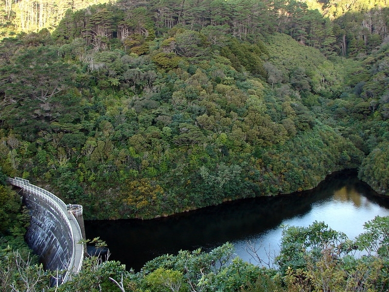
Completed in 1908, the Upper Karori Dam lies across the Kaiwharawhara Stream in the upper south Kaiwharawhara valley. Built on what had been privately owned farmland, the dam was constructed to supplement the Wellington City water supply provided by the existing (Lower) Karori Dam, which had become inadequate due to the pressures of a growing population. Proposals for an extension of the Karori Waterworks had been put forward since 1900. It was not until 1904, however, that these proposals were accepted by ratepayers. Farmland was taken in the upper part of the Kaiwharawhara valley under the Public Works Act for the extension of the waterworks. This effectively ended farming in the Kaiwharawhara valley. Following the plans drawn up by the City Engineer W.H. Morton, the contractors Mitchell and King commenced construction in 1906. The Upper Karori Dam was built as a curved concrete gravity dam, the first largescale concrete gravity dam in New Zealand. The dam was built as a one volume mass (monolithic) concrete structure without vertical joints as is done in the construction of modern dams. The concrete was used in an interesting way, with an inner core of low strength concrete encased in a layer of high strength concrete. There has been a nominal amount of alteration to the dam since the time of its construction. An additional source of water from Long Gully was pumped into the upper reservoir in 1945, the original cast iron pipes were replaced in 1962, and in 1980 the spillway was reconstructed. In 1978, however, an engineer's report found that the dam was positioned precariously over the Wellington Fault, and that curve of the dam would provide limited stability against earthquake forces. The lake behind the dam was lowered, and in 1991 the dam was decommissioned. The Upper Karori Dam is an example of an early twentieth century dam that is significant to the history of Wellington as a feature of the development of the city's public water supply. The need for the Dam, which is set within an aesthetically pleasing and secluded part of the upper south Kaiwharawhara valley now part of Karori Wildlife Sanctuary, arose from growth in Wellington's population. As the first largescale concrete gravity dam in the country, and an example of early and interesting use of concrete, the dam was considered an engineering accomplishment of its time. Having remained virtually unaltered from the time of its construction is a testament to this accomplishment. Several archaeological features associated with the construction of the dam are located in the vicinity, and provide an illustration of the construction practices used. The accessibility of the dam, together with the archaeological features (including some reconstructed features such as a cable tower and work huts) identified and interpreted by the Karori Wildlife Sanctuary, provide a great opportunity for public education in early twentieth century dambuilding practices.
Location
List Entry Information
Overview
Detailed List Entry
Status
Listed
List Entry Status
Historic Place Category 2
Access
Able to Visit
List Number
7749
Date Entered
5th May 2008
Date of Effect
5th May 2008
City/District Council
Wellington City
Region
Wellington Region
Extent of List Entry
Includes part of the land described as Lot 1 DP 313319 (RT WN52413), Wellington Land District structures collectively known as the Upper Karori Dam thereon, and its fittings and fixtures. The registration includes the dam formation, valve tower, spillway, pipes, upper reservoir and other associated features detailed in the physical description section of the Registration Report. The registration also includes all items integral to the operation of the historical dam structures described in the Registration Report. Registration excludes reconstructed elements. The registration also excludes other items not associated with the historical dam structures but contained within the boundary of the registration, for example the predator proof fence. (Refer to Extent of Registration Map in Appendix 1 of the Registration Report for further information).
Legal description
Lot 1 DP 313319 (RT 52413), Wellington Land District
Location Description
Located within the Karori Wildlife Sanctuary, Wellington.
Historic Significance
Historical Significance or Value The Upper Karori Dam is associated with the history of Wellington's water supply as an extension to the Karori Waterworks, the first public water supply for the city. The required extension to the waterworks is an illustration of the growing population of Wellington city during the late 19th and early 20th century.
Physical Significance
Aesthetic Significance or Value The crest of the Upper Karori Dam provides a platform for visitors to gain a magnificent view of the curved concrete gravity dam on both its upstream and downstream faces and of the surrounding valley down towards the Lower Karori Dam. From the crest of the dam visitors can also gain a superb view of the upper reservoir which is now populated with bird life and native plantings. While adding to the aesthetically pleasing surroundings the visible change in the vegetation above the reservoir is also telling of changes to the original reservoir levels. Archaeological Significance or Value The Upper Karori Dam remains relatively unmodified and in good condition. The survival of many of the elements of its construction in a good state of preservation is rare for a large scale early 20th century construction project. The Upper Dam forms a significant industrial archaeological landscape which is illustrative of early 20th century construction techniques. It provides a great opportunity for the promotion of industrial archaeology. Technological Significance or Value The Upper Karori dam is an early example of the use of concrete in New Zealand, and an interesting example of two strengths of concrete in its construction. The dam was considered an engineering accomplishment of its time and has remained virtually unaltered from the time of its construction. The Dam is the first largescale concrete gravity dam built in New Zealand.
Detail Of Assessed Criteria
(a) The extent to which the place reflects important or representative aspects of New Zealand history The Upper Karori Dam reflects the dambuilding and waterworks engineering history of early Wellington. In the national context, it is an early example of a dam constructed in New Zealand. (c) The potential of the place to provide knowledge of New Zealand history The Upper Karori Dam can help illustrate techniques of early concrete dam building, especially in its monolithic formation and use of two different strength concretes. The archaeological sites associated with the dam provide a good illustration of the construction practices of building an early gravity dam. (e) The community association with, or public esteem for the place The dam is featured in Robert Offer's (a qualified engineer) book on pioneer dam building in New Zealand as the first largescale concrete gravity dam in the country, and an example of an early water supply dam. Offer notes the use of two strengths of concrete in the dam's construction as an 'interesting feature.' The publication of this book was supported by the New Zealand Society on Large Dams (NZSOLD). The publication is now sold on the NZSOLD section of the Institution of Professional Engineers New Zealand (IPENZ) website. (f) The potential of the place for public education The accessibility of the dam, in that the public can walk across its crest, together with the archaeological features reconstructed and interpreted by the Sanctuary, has great potential for public education in early twentieth century dambuilding practices. The dam provides a spectacular viewing platform to appreciate the landscape and wildlife of the upper south Kaiwharawhara valley. The visible change in the vegetation when looking above the water level today gives a sense of how impressive the full upper reservoir must have been. When considered together with the Lower Karori Dam, there is a great potential to illustrate the development of the Karori waterworks. (g) The technical accomplishment or value, or design of the place The Karori Upper Dam was the first largescale concrete gravity dam built in New Zealand. That the dam was built as a mass concrete structure without construction joins, and that it has remained virtually unmodified since its construction are testaments to its technical accomplishment. (k) The extent to which the place forms part of a wider historical and cultural complex or historical and cultural landscape The Upper Karori dam is particularly important in its association with the existing Lower Dam, which together provide illustration of the development of the Wellington water supply, and in more recent times, the development of the Karori Wildlife Sanctuary. Conclusion The Upper Karori Dam is an example of an early twentieth century dam that is significant to the history of Wellington as a feature of the development of the city's public water supply. The need for the Dam, which is set within an aesthetically pleasing and secluded part of the upper south Kaiwharawhara valley now part of Karori Wildlife Sanctuary, arose from growth in Wellington's population. As the first largescale concrete gravity dam in the country, and an example of early and interesting use of concrete, the dam was considered an engineering accomplishment of its time. Having remained virtually unaltered from the time of its construction is a testament to this accomplishment. Several archaeological features associated with the construction of the dam are located in the vicinity, and provide an illustration of the construction practices used. The accessibility of the dam, together with the archaeological features (including some reconstructed features such as a cable tower and work huts) identified and interpreted by the Karori Wildlife Sanctuary, provide a great opportunity for public education in early twentieth century dambuilding practices.
Construction Professional
Biography
William Hobbard Morton was born 26 July 1866 and was educated in Melbourne. He became Acting City Engineer and Surveyor for the Wellington City Council on 18 March 1904. On 1 August he became City Engineer and Surveyor for a further 2 years and 7 months, finally retiring due to ill health in 1923. Morton died in June 1923. (Registration Report, Upper Karori Dam, 1 May 2008; Registration Report, Tram Shelter, Wellington, 8 Oct 2012).
Name
Morton, William H
Type
Architect
Biography
No biography is currently available for this construction professional
Name
Mitchel, William
Type
Builder
Biography
Frederick William King was born in Essex, England, in c.1852. He immigrated to New Zealand in c. 1876. King settled in Masterton where he helped to construct many of the town buildings through his association with Messrs. Brown and Rodgers, building contractors, and, later, with Arthur Cleghorn, building contractor. During the 1890s King went into partnership with Michael Williams. When Williams died in the construction of the Wairarapa Farmers Commercial Association building in 1897, King completed the commission for the internal woodwork. For most of the next 31 years King established a construction business with his son, William Dallenger King. During this time he was also employed by Messrs C E Daniell. Frederick King was responsible for a number of major buildings in Masterton including the Courthouse (1908), the Fire Brigade Station (1910), and J L Murray's block of buildings. As well as building Barnstone Lodge (Awamaru/Awamanu), the family home until 1916, King also built a house for Walter Perry and at least 3 houses in Worksop Road. He retired in 1920 and died in Masterton on 26 May 1933.
Name
King, Frederick
Type
Architect
Construction Details
Description
Plans of dam dated 15 March
Start Year
1906
Type
Designed
Description
Construction began (contract signed 22 September 1906); formally opened 29 November 1908.
Finish Year
1908
Start Year
1906
Type
Original Construction
Description
Position of by-wash altered to east side (plans dated 29 November 1907)
Start Year
1907
Type
Modification
Description
Water pipes were laid to pump water from Long Gully, a branch of the South Karori Stream, 120m over the saddle behind the Upper Dam to supplement the upper reservoir.
Start Year
1945
Type
Other
Description
Original cast-iron pipes replaced.
Start Year
1962
Type
Modification
Description
Spillway reconstruction.
Start Year
1980
Type
Reconstruction
Description
Catchment and collection into Upper Dam ceased, dam lowered and decommissioned.
Start Year
1991
Type
Other
Construction Materials
Concrete
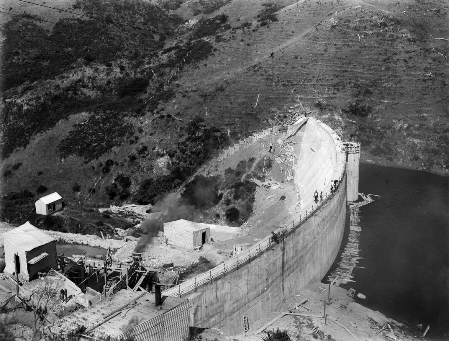
It is likely that in pre-European times the Karori Reservoir Valley was used by Maori for birdtrapping and collecting food, although they do not appear to have lived in the area. Indeed, the word Karori is derived from Karore which came from kaha or ka (ropes) and rore (snare) and therefore means 'snare ropes'. The recognised iwi authority in the area is Te Ati Awa and its people Tangata Whenua. European settlement began in the Karori area following the purchase of the Wellington region by the New Zealand Company in 1839. By the 1850s the bush had been largely removed, and sheep and cattle were grazed on the land. In 1871, several landowners were affected by the Wellington Water Works Act which, for the purpose of supplying the city with water, took 228 acres of land along the Kaiwharawhara Stream. In 1878 a dam was completed in the lower part of the Kaiwharawhara valley (to be known as the Lower Karori Dam). Farming continued in the upper part of the valley, where stock was run on open grassland and scrub. There was great confidence in the water supply provided by the Karori reservoir and Wainuiomata reservoir (formed by a small earth dam constructed in 1884), yet by 1900 it was evident that a supplementary water supply was necessary. With a growing Wellington population and inadequate rainfall, both supplies were failing to meet demands. In 1900 and 1902 proposals were made by the City Engineer, R.S. Rounthwaite, for additional storage at Wainuiomata to supplement the existing reservoir; these proposals, however, were refused by ratepayers. 1904 was a year plagued with earthquakes, droughts and floods, revealing the limitations of the existing Wainuiomata and Karori reservoirs and demonstrating further the need for additional supplies. In this year W.H. Morton became City Engineer. He endorsed Rounthwaite's Wainuiomata proposal, and added to it an extension of the Karori waterworks. Ratepayers accepted Morton's proposal: the Karori reservoir was to be supplemented by the construction of a curved concrete gravity dam to be located about 1km upstream of the existing Lower Karori Dam. The Wainuiomata reservoir was to be supplemented by a concrete buttress dam that became known as the Morton dam, completed in 1911. The extension of the waterworks area effectively saw the end of farming in the valley, when in 1906 the area was taken under the Public Works Act, zoned as water supply catchment and closed to the public. Over 516 acres of land was taken, mostly from the farmer AB Fitchett. In previous years farming in the upper south Kaiwharawhara valley caused problems with pollution to the water catchment. In 1904, 'casualties in the Karori catchment were two horses, five cows, four calves, 26 sheep, 22 lambs and one dog.' By 1908, animal casualties in the upper reservoir were nil. On 22 September 1906 the contractors Mitchell & King signed a contract with the Wellington City Council to construct the Upper Karori Dam, following the plans prepared by Morton. The contract specified the completion of a 'concrete dam with valve tower, byewash [i.e. spillway] with training and revetment walls, weir, etc and the construction of a road with a light tramway from the existing reservoir [i.e. Lower] at Karori to the site of the new dam,' at an estimated cost of £23,990, 11 shillings and 9 pence. The contract stipulated that all work was to be completed on or before 12 September 1907, and a two pound penalty would be charged per day the contract remained incomplete. The water catchment area was protected by clauses in the contract, for example: the use of explosives prohibited; all materials to be removed using picks and shovel; no pollution of the streams to the upper reservoir; no horses to be stabled at the work site; no workmen except watchman to live on the site; spoil (waste material) to be within 5 chains (100m) of new dam; and all materials to be removed from the site within 3 months of completion. The Upper Karori Dam would be built as a one volume mass (monolithic) concrete structure, i.e. without vertical joints dividing the dam into blocks as is done in the construction of modern dams. It was the first largescale concrete gravity dam built in New Zealand. While concrete was used on the upstream face of the Lower Karori earth dam and in the construction of some small weirs throughout the country in the 1880s and 1890s, it was not until the early 1900s that several small and two large concrete gravity dams (the Upper Karori Dam in 1908 and the Waitakere Dam in 1910) were built in New Zealand for water supply. The concrete used in the dam construction was made with Portland cement, and was poured in a series of horizontal layers, which are visible on the downstream face of the dam. In order to link each layer of concrete to the next, ‘spalls' ‘selected rocks no more than 12 inches in any direction' were beaten into each layer with their tops protruding. This acted as a ‘key' onto which the next layer of concrete was joined. Offer explains how concrete was utilized in the dam's construction: The inner ‘core' of the dam consists of concrete made with a coarse aggregate probably from a quarry on the left abutment of the dam. This core was encased in a skin of higher strength concrete made with a clean river gravel aggregate and placed separately against the core concrete. This feature has something in common with a similar form of construction in modern concrete gravity dams which in higher quality concrete is placed to form the faces of the dam. However, the modern technique is to place both concretes together. A report by engineers Beca, Carter, Hollings and Ferner noted that the original drawings for the Upper Kaori Dam show some ‘as constructed notes': These indicate that the dam foundations were excavated to a greater depth than was originally required by the drawings. This suggests that either poor quality rock was found or that the shatter zone along the Wellington Fault was encountered and had to be excavated to firm material. The drawings also show the original stream and ground levels and these can be compared with the present ground levels to indicate the amount of backfill placed. Similarly, while the spillway would be constructed on the dam's right abutment, the plans show that the spillway was originally going to be built on the left abutment. Further information on the construction of the dam comes from research done by Alison For, who completed a heritage inventory on the Karori Wildlife Sanctuary in 2002, and the Combined Rotary Clubs of Wellington for the Wellington Rotary Centennial Karori Wildlife Sanctuary Discovery Project in 2004. Both drew on material such as historic photographs, original contracts and plans. Historic photographs for example show the tramway that was used to transport materials to the top of the dam, the line of which can still be seen when following the Lake Road through the Sanctuary. Another historic photograph suggests that the clearing below the Upper Dam, which consists of tunnels, pipes, races and surge tanks from the dam and the main valve shut off for the dam, was likely the lower level construction area and that a terraced area above the finished level of the dam was used as the upper level construction area. The Combined Rotary Clubs of Wellington also drew together information on the construction of other dams, such as the Wainuiomata (Morton) Dam, to add to what they knew about the construction of the upper dam. Based on this information, as described on the interpretation panels around the Upper Dam, a system of cables, supported by a 1012m timber tower, would have been vital to the dam's construction. They suggest this tower would have dominated the upper construction area in the year 1907. In order to accommodate the curve of the dam face, the tower would have been mounted on four bogies (wheels), and winched along two parallel pairs of heavygauge rails; to date, three of the bogies have been found in the Sanctuary. A hopper (a funnel shaped bin) would then have moved along the cableway reaching across the valley, and poured concrete where required along the radius of the dam. The area the tower moved along had to be level, and it has been suggested that this was done by hand with picks and shovels. In other interpretation panels the Combined Rotary Clubs of Wellington describe how water collected at a rock dam, the remains of which can still be seen, passed through a system of pipes to be used for a variety of functions in the construction of the upper dam. They note that water was needed for washing aggregate, batching concrete, to power steamdriven machinery and providing drinking water for the workers especially ‘cups of tea'. They also discuss how corrugated iron and timber sheds were erected, most probably to store coal and tools and to provide shelter for the workmen. Some evidence of these building sites can still be seen in the excavations at the rear of the construction area (the Sanctuary has placed a replica hut near the existing hut sites, which are situated on the Campbell Street Track). A partially collapsed corrugated iron shed also exists near the top of the upper dam (below where the Campbell Street Hut sites are situated). Alison For points out that this hut may have been used in the construction of the dam as the tender for the Upper Dam specifies the construction of two huts, a shed for mixing and storage of cement and an office for clerk of workers. By 1908 the Upper Karori Dam was complete, and on March 12 1908 it was taken over from the contractors by the Wellington City Council. The Upper Karori Dam was constructed to stored 266 million litres (59 million gallons), with 177.2m (581.4 ft) of top water. Years later however, the dam which had itself been built to supplement an insufficient supply could not keep up with Wellington's demand for water. In 1943 a report showed a deficiency in Wellington's water supply, causing a depletion of the upper reservoir, which had been ‘called upon to make up the balance.' Consequently, in 1945 the upper reservoir was supplemented by water uplifted by pumps 120m from Long Gully, a branch of the South Karori Stream. This supply was discontinued in 1956 when the Hutt River source was brought into Karori. With such developments, the function of the Upper Karori reservoir altered: from a water supply reservoir to a reserve reservoir to be used when other sources are unavailable, for example when supplies from the Hutt River become turbid and unusable in floods. The ‘useable storage' was estimated in 1975 as 200 million litres (44 million gallons). In 1978, a safety appraisal was undertaken by consulting engineers Beca Carter Hollings and Ferner. In order to review its stability, water pressures were measured under the dam and were found to be significant enough to pose risk. Dam designers at the time did not account for the significance of water pressure under a dam which arises from lake water seeping through the bedrock. Indeed, the need to consider this factor was only slowly being recognised throughout the world. Further investigation revealed that the curve of the dam in fact only contributed a small amount to its stability, and this was insufficient to protect the dam against the force of an earthquake. This means that while it is indeed curved to have the appearance of an arch dam, which Offer says was a common practice at the time, only a small contribution to the stability of the dam arises from the arch effect. The dam's position is particularly precarious considering its (unbeknown at the time of construction) positioning across the Wellington fault. According to the Beca Carter Hollings and Ferner report, despite the earthquake risk, the dam was generally in ‘sound condition' with the exception of the spillway. The report noted that ‘the spillway chute downstream of the crest' was in ‘very poor condition' with severe damage possible if ‘large spillway flows occurred'. The higher strength concrete on the surface had broken away in places exposing the low strength concrete beneath while the timber spillway chute had completely collapsed causing water to bypass the concrete stilling basin. The report recommended that the spillway be repaired by ‘replacing the defective concrete' and reconstructing the collapsed timber chute. Plans from 1980 indicate that the timber portion of the spillway was subsequently reconstructed and it seems likely the minor repair work to the concrete took place at this time. As far as John Fraser (reservoir caretaker from 1960 to 1997) is aware, no major maintenance work was carried out on either of the dams during the time he was there: the original pipes were cast iron and were replaced in 1962 because of rust barnacles inside them, but no further detail given. Therefore, from the information available, it appears that the dam has remained virtually unaltered from the time of its construction. In 1992 the Upper Karori Dam was partially emptied due to earthquake risk following the commissioning of the Ngauranga Water Supply Pumping Station. Thus the water level behind the lake was lowered, and today there is an obvious change in the vegetation above the lake which illustrates its previous height. After the Upper Karori Dam was partially emptied and no longer used as part of Wellington's water supply, efforts to keep people out of the area were reduced. However, with the commencement of the Karori Wildlife Sanctuary development in 1993, public access to the valley was restricted until 2002 when the Sanctuary opened seven days per week. In 2004 the Sanctuary opened the ‘Discovery Area,' in which the Upper Dam construction area was developed and interpreted for the public. The Sanctuary developed the Discovery Area with the Combined Rotary Clubs of Wellington. The project served to commemorate Rotary's centenary, which took place in February 2005. Several reconstructed features (reconstructed cable tower/lookout and hut, replica skip and new tracks through the bush) and interpretation signage explaining both original and reconstructed features, were installed. Other changes in the Upper Karori Dam area include the addition of a pair of binoculars, a wooden platform and movable steps atop of the builtin valve tower in the middle of the top of the dam. These were added by the Sanctuary in 2004 to allow people of varying heights to better view the water fowl in the reservoir below. Other modern equipment has been fitted to the handrail of the barrier that runs along the top of the dam. This equipment includes a telemetered water level recorder and solar panel fitted by Capacity; a rain gauge added by Greater Wellington in approximately 2006, and a wind meter and solar gauge added by NIWA at the request of the Sanctuary in 2007. In 2006 Capacity designed and fitted a protective cap to the normal overflow pipe intake in the upper reservoir to overcome debris blocking the pipe.
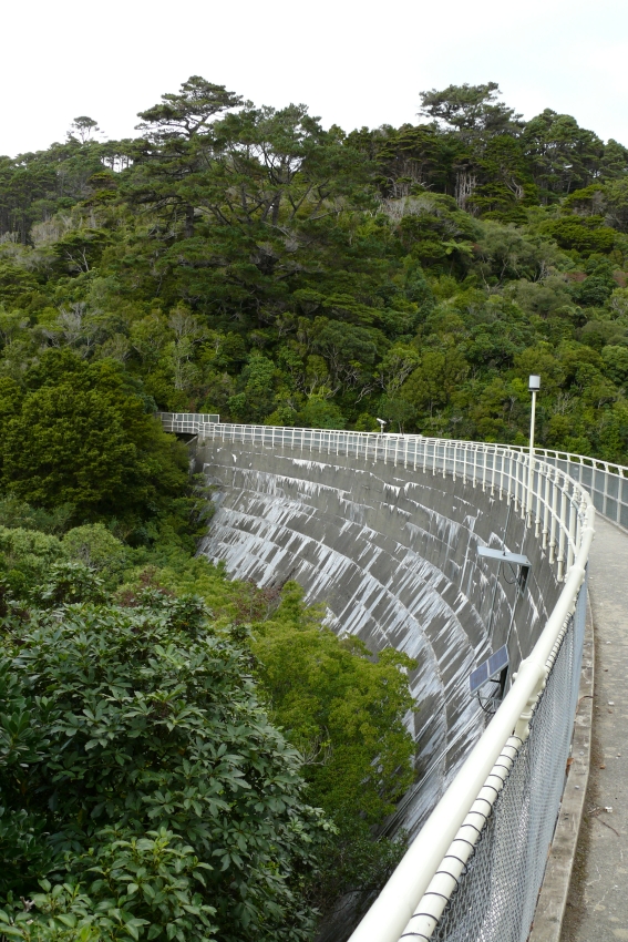
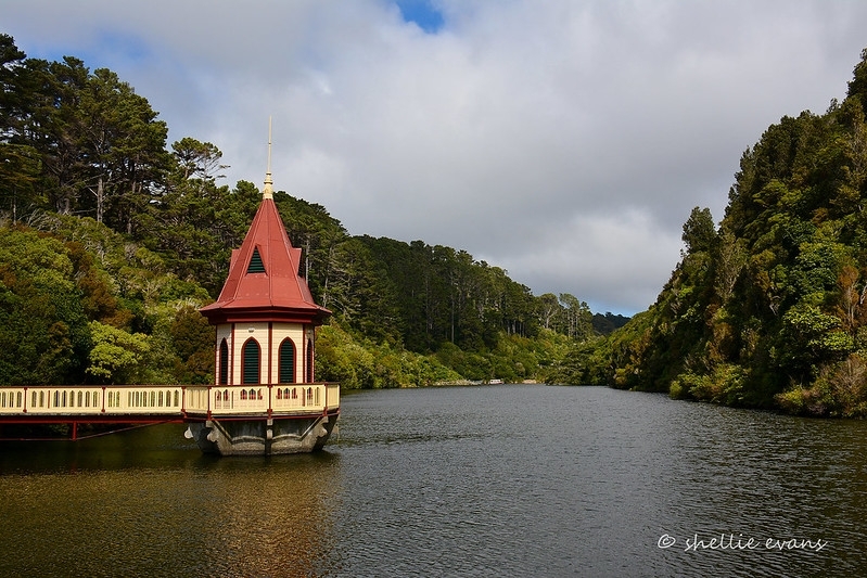
The Dam General Location The Upper Karori Dam is located in the upper south Kaiwharawhara valley. To the north west lies the suburb of Karori and to the north east is Kelburn. Highbury and Brooklyn lie to the east. To the south are the areas of Karori South and Happy Valley. Description of site Set in a secluded part of the upper south Kaiwharawhara valley, the Upper Karori Dam is surrounded by regenerating native bush. The bush grows up to the downstream face of the dam, and tracks through the bush providing access to its crest. Facing south, there is the upper reservoir, which is home to a variety of birdlife. Beyond the upper reservoir to the south lies the upper reaches of the Karori Wildlife Sanctuary. To the north of the dam is the lower part of Sanctuary and beyond is the Lower Karori Dam. To the upper west side of the valley a reconstructed cable tower (described below) can be seen, marking the place of the Dam's upper level construction area. To the immediate north is a grassy area marking the lower level construction area. Description of dam Crossing a wide asymmetric valley with a steep right abutment and gentler left abutment, the dam consists of a curved concrete wall with a 300ft (90m) radius, with the top water level behind the dam being 70ft (20m) above the streambed. The dam can be accessed from both the east and west side, following walking tracks though the Sanctuary leading right up to the crest of the dam, which can be then walked right across. Following the main track from the entrance of the Sanctuary (the Lake Road), at the junction at the bottom of the dam, two tracks can be taken to the west side of the dam. One winds its way up with a gentler gradient (Swamp Track); the other is steep and straight, this being the line the original tramway took during the construction of the dam (Lake Road continuation). The track to the east side of the dam is far less direct (Beech Track). The way across the dam is fenced with a metal railing/wire netting barrier. Modern equipment has been fitted to the handrail of this barrier including a telemetered water level recorder and solar panel, a rain gauge, a wind meter and a solar gauge. In the middle of the dam, atop of the builtin valve tower, is an area with cogged fixtures painted with the letters F, H, and G. There is a pair of binoculars, with a wooden platform and movable steps to allow people of varying heights to use the binoculars. Looking at the upper reservoir from the dam, it is possible to see a variety of wildlife, both on the water and the 'floating islands' with native plantings developed by the Sanctuary on which birds make their home. It is possible to see how far up the water reached when the upper reservoir was at capacity by a change in the vegetation above the lake. The vegetation is scrubbier and sparser where the water had previously been. The valve tower includes a 380mm diameter pipe with three inlets at various levels and a 600mm diameter scour pipe at the base. A tunnel has been driven around the lower reservoir to enable flood flow from the upper reservoir to bypass the lower reservoir. Beca Carter Hollings and Ferner describe the three outlets from the dam: 'a 24 inch diameter discharge pipe into the stream below the dam; an 8 inch diameter pipe which discharges directly to the lower reservoir; and a 15 inch main which passes around the lower reservoir and can feed directly into the water supply system. This main can also be used to fill the upper reservoir by pumping from the water supply system.' The main shut off valve is located in a grassy area to the north of the dam (see lower level construction area). The spillway is located on the east side of the dam, and here the barrier fence is much higher than it is along the rest of the dam crest. The upper concrete portion of the spillway can be viewed from this section of the dam. The lower timber portion and concrete baffle of the spillway can be viewed from the upper Te Mahanga Track lawn area under the dam. However the ground around the concrete baffle at the bottom of the spillway can be under water and is otherwise often soft and wet, so public access is not encouraged. Also, during the breeding season (SeptemberMarch) there have been saddleback and stitchbird nesting in that location, and staff at Karori Wildlife Sanctuary advise that they are best left as undisturbed as possible. The spillway is 42m long and the lower 18m is timber in good repair. On the east abutment is a concrete wall with painted vertical markings and mostly illegible writing on it. These markings seem to mark the height of something and one word appears to reads 'Highbury.' Condition of dam Good: Cracks occur along the horizontal construction joints, but 'autogenous healing' has sealed off any water flows, which can be seen in the thick flow deposits of calcium carbonate on the downstream face of the dam. Burch describes these deposits as 'efflorescence lines.' Appearance of Associated Features Lower Level Construction Area The grassy clearing below the dam, once the lower level construction area, consists of tunnels, pipes, races, surge tanks and the main valve shut off for the Upper Dam. The valve shut off sits in the centre of this grassy clearing. There are two large disused pipes lying up a track near this area. Tramway Today the line of the tramway is used as an access track to the top of the dam, forming part of the track known as the Lake Road. The line of the formation can still be traced. Because of its straight and steep incline, it can easily be imagined as a tramway, and is particularly obvious when compared to a historic photograph. In a clearing near the base of the track (junction of Lake Road and Swamp track) disused tram rails lie down a bank. About halfway up the track there is exposed piping protruding from the middle of the track, and nearby on the outer edge of the track is concrete with a metal fixture in it. Corrugated Iron Shed There is a partially collapsed corrugated hut located near the dam, close to the junction of the Campbell Street Track and the Round the Lake Track. Originally standing at 2m at the eaves and 3m at the pitch of the roof the hut now occupies a small terrace 4m long and 2.4m wide. An examination of the hut in 2002 indicated that it has a corrugated iron leanto or add on and that a concrete base of a stove next to the bank on one side. Metal cables can also be seen in the area. Quarry, Bogie Wheels and Curved Track There are visible remains of the quarry that was used during the construction of the dam. Located near the corrugated iron hut at the junction of the Campbell Street track and the Round the Lake track, the quarry can be seen as a face/slope of uniformly shaped rocks, visible through the trees. Near the quarry lies a pair of bogie wheels. The Sanctuary has placed interpretation relating to the quarry and bogie wheels in this area. The quarry is linked to the upper level construction area by a curved track. As far as can be ascertained, this track has remained unaltered, part from the wooden steps (made from railway sleepers) laid by the Sanctuary partway up the track. Upper Level Construction Area A large flat area situated on the western side of the valley overlooking the dam, marked on the southern end by a shelterbelt of large macrocarpa pines marks the place of the Dam's upper level construction area. The Sanctuary has named this area 'The Terrace,' and it forms part of their Discovery Area. There is now a fullsized timber reconstruction of the cableway tower placed in this area, which can be climbed and provides a spectacular view of the dam and the lake below. Just along from where the reconstructed tower is situated, a restored skip, much like those thought to be used in the construction of the dam, has been placed. Rock Dam Now collapsed and overgrown, the rock dam used for various purposes in the construction of the dam, was originally about 2.5m high and constructed using rock quarried from the site. The Sanctuary has placed interpretation relating to the rock dam in this area. Campbell Street Track Hut Sites These building sites near the upper level construction area are thought to have housed storage huts. These sites are set back from the main Campbell Street Track and cut into the bank. Flattened rectangular areas are all that remain as evidence of these sites, which are now overgrown by bush. Interpretation signage points out these sites. Further down the track along from the hut sites, the Sanctuary has placed a replica hut which contains interpretation panels inside about the history and construction of the dam.
Completion Date
5th May 2008
Report Written By
Emma Meyer
Information Sources
Burch, 1997
J Burch, The Karori Reservoir Area - A Brief History. Karori Historical Society: Wellington, 1997.
For, 2002
Alison For, Heritage Inventory Karori Wildlife Sanctuary, RECN 512 Practicum, 2002.
Karori Wildlife Sanctuary, 1997
Karori Wildlife Sanctuary. Karori Wildlife Sanctuary Management Plan (Draft). Wellington: Karori Wildlife Sanctuary, 1997.
Morrison, 1986 (2)
Sally Morrison, A History of the Water Supply in the Wellington Region. Wellington: Wellington Regional Council, 1986.
Offer, 1997
R E Offer, Walls for Water: Pioneer Dam Building in New Zealand. Palmerston North: The Dunmore Press Ltd, 1997.
Patrick, 1990
M Patrick, From Bush to Suburb: Karori 1840-1980, Wellington, 1990, Karori Historical Society
Report Written By
A fully referenced version of the registration report is available from the NZHPT Central Region Office Please note that entry on the New Zealand Heritage List/Rarangi Korero identifies only the heritage values of the property concerned, and should not be construed as advice on the state of the property, or as a comment of its soundness or safety, including in regard to earthquake risk, safety in the event of fire, or insanitary conditions.
Current Usages
Uses: Civic Facilities
Specific Usage: Lake/Pond
Uses: Civic Facilities
Specific Usage: Lookout
Uses: Civic Facilities
Specific Usage: Recreation Reserve/Scenic Reserve
Uses: Utilities
Specific Usage: Reservoir/ Dam
Former Usages
General Usage:: Utilities
Specific Usage: Reservoir/ Dam
Themes
IPENZ Heritage Register
Stay up to date with Heritage this month
