

Planning for the NIMT began in the 1870s, but it took nearly 40 years for the railway to be completed. When construction of the NIMT actually began it was a protracted process and New Zealanders were becoming impatient for it to be concluded by the beginning of the 20th century. This public dissatisfaction spurred the government to feed more resources into a 'final push.' This section between Ohakune and Raurimu featured a difficult and rugged landscape, unsuited to railway building, and consequently it contains a large proportion of bridges and earthworks. In accordance with Julius Vogel's plan, the construction of this engineering feat attracted immigrants to New Zealand, many of who stayed in the area after the project was completed and formed the foundation of the settlements along the railway. Once the Central Plateau's landscape had been penetrated by the NIMT it opened up the area for more settlement and the growth of industry. On a national level, the NIMT was a vital means of passenger and freight transport until it was surpassed by road transport in the late 20th century.
Work on the Mangaturuturu Viaduct began in 1907 and was finished only one month prior to the completion of the NIMT. Like other Peter Seton Hay designed viaducts, it is a truss span viaduct, and it crosses the Mangaturuturu River by way of two Warren truss girders and a main central mass concrete pier which is flanked by small concrete piers at either end. The viaduct has undergone regular maintenance over the years and its foundations received particular attention in the later half of the 20th century because of the river's reputation as an outlet for Mount Ruapehu's volcanic activity. Other additions to the structure are reflective of the history of operational and technological changes in the New Zealand railway network.
The Mangaturuturu Viaduct was an integral component in the 'final push,' and the completion of the NIMT, which is of historical importance in New Zealand because it revolutionised transport and was essential to the country's economic development. This viaduct is also invested with significance because it is one of a diminishing group of NIMT construction era, 'final push,' structures which is still a functioning part of the railway and this stands it apart from many of its contemporaries in the area. The longevity of the structure can be attributed to the technical skill and competence of those involved in designing, manufacturing the fabric for, and constructing the Mangaturuturu Viaduct, as well as subsequent care in managing and maintaining it.
List Entry Information
Status
Listed
List Entry Status
Historic Place Category 2
Access
Private/No Public Access
List Number
7779
Date Entered
20th February 2009
Date of Effect
20th February 2009
City/District Council
Ruapehu District
Region
Horizons (Manawatū-Whanganui) Region
Extent of List Entry
Extent includes part of the land described as the NIMT rail corridor and the structure known as the Mangaturuturu Viaduct thereon, including its abutments (Refer to map in Appendix 1 of the registration report for further information).
Legal description
NZ Gazette 1910, pp.596-597
Location Description
The viaduct is immediately adjacent to the State Highway 4 (SH4) bridge (no.1299) between Horopito and Pokaka. There are areas to park on the shoulders of the road on either side of the highway bridge.
Why is this place significant?
Historic Significance
Historical Significance or Value The Mangaturuturu Viaduct has national and local historical importance because of its inclusion in the massive engineering feat which was the NIMT and, more particularly, the last stages of the 'final push' to complete it. The construction of the NIMT took 23 years and was only made possible because of the agreement of some Maori to allow surveying in, and eventually the establishment of the railway reserve through, the restricted area of the Rohe Potae. This access initiated one of the most expensive state projects undertaken in New Zealand; expenditure which was justified by the governments of the time as a means of gaining a foothold in the King Country, of encouraging immigration to New Zealand, and stimulating settlement in the central North Island. The NIMT also promised to create huge economic benefit upon completion, and by 1908 this motivator depended on the timely and successful completion of the Makatote, Manganui-o-te-ao and Mangaturuturu Viaducts, which makes the Mangaturuturu an important NIMT structure. Despite being humble in size, the Mangaturuturu Viaduct is imbued with significance because out of the seven viaducts in the NIMT's 'final push,' it is one of only three that are still a functioning part of the railway. It is also remarkable because it was the third to last structure finished on the NIMT and is the highest railway structure above sea level in New Zealand. Until rail's transportation pre-eminence was surpassed by road in the late 20th century, the Mangaturuturu Viaduct proved to be a vital link for the local and national economy. The alterations to the viaduct over time reflect the major changes in rail operational practices over the 20th century, and are indicative of the importance placed on maintaining the structure to ensure it continued to be a viable part of the NIMT. The changes to the viaduct are also linked with noteworthy events in New Zealand's history such as the Tangiwai Disaster and subsequent volcanic activity on Mount Ruapehu.
Physical Significance
Technological Significance or Value: The Mangaturuturu Viaduct is a characteristic, NIMT construction era bridge in terms of its construction materials, method, length and height. However, it is an exceptional representative example because it was constructed at the highest altitude of any other railway structure within New Zealand and its longevity is phenomenal given the exposure and often harsh conditions and natural phenomena it has withstood. This, and the fact that it is still a part of the operating line, is a tribute to the initial design for the Mangaturuturu Viaduct, the contractor's skill in manufacturing quality steel superstructure components, and also the technical prowess of the manual labour force which constructed the structure.
Why is this place Category 1 / Category 2?
Detail Of Assessed Criteria
(a) The extent to which the place reflects important or representative aspects of New Zealand history: The Mangaturuturu Viaduct is a lasting reminder and example of the enormous engineering feat which was the construction of the NIMT. This railway was the main arterial transport route for freight and passenger traffic for most of the 20th century, and the Mangaturuturu Viaduct was, and still is, an integral functioning part of the NIMT and its history. (b) The association of the place with events, persons, or ideas of importance in New Zealand history: Because it was designed by Peter Seton Hay, the Engineer-in-Chief of the Public Works Department, the Mangaturuturu Viaduct also has an association with this important engineer and the other structures he designed during his career. Out of the viaducts which Hay designed for the NIMT, the Mangaturuturu Viaduct is rare because it is the only remaining example of a two truss span viaduct with a central concrete pier. The viaduct's construction by J & A Andersons Ltd is also important because they feature significantly in New Zealand engineering history as one of the earliest firms established who also undertook numerous important projects, as well as the fact that the founder was an important personality in the development of Christchurch. The Mangaturuturu Viaduct was finished only one month prior to the completion of the NIMT. Therefore, as one of the last structures completed on the NIMT it has a direct association with this important historical event. (f) The potential of the place for public education: The Mangaturuturu Viaduct is closely linked to other rail heritage structures in the area and could be included in a regional historic rail trail. (g) The technical accomplishment or value, or design of the place: The viaduct demonstrates initial and subsequent technical accomplishment because it continues to serve its purpose well, showing no signs of major deterioration in its general form. In particular, the Mangaturuturu Viaduct's longevity, with only a few instances of significant remedial work, demonstrates the quality of its design and the technical skill of those who manufactured its fabric and constructed it. Added value is also attributed to this viaduct because it is the highest altitude functioning structure on a New Zealand railway which added a degree of difficulty during its construction and has tested the quality of its fabric and construction techniques against the challenges posed by the environment. (k) The extent to which the place forms part of a wider historical and cultural complex or historical and cultural landscape: The NIMT stretches from Wellington to Auckland and the Mangaturuturu Viaduct is an important component within it along with other 'final push' structures. In this way the viaduct contributes to the larger historical landscape of the North Island and, in particular, that of the Central Plateau region. Other structures in the viaduct's vicinity include the 'Last Spike' memorial, the Makatote Viaduct, the Taonui and Hapuawhenua Viaducts, the Ohakune to Horopito Old Coach Road, and the historic rail precinct at Ohakune Junction. It is also associated with the Tangiwai Memorial Reserve because of the measures that were taken to minimise the risk of a similar disaster at Mangaturuturu. As part of this group the viaduct can be linked into the wider context of the NIMT and its historical and economic affect on the area. Summary of Significance or Values: This place was assessed against, and found to qualify under the following criteria: a, b, f, g, and k. Conclusion: It is considered that this place qualifies as a Category II historic place.
Construction Professional
Name
J & A Anderson Ltd
Type
Builder
Biography
The New Zealand engineering firm of Anderson Limited (later J & A Anderson Ltd) was established in 1850 by John Anderson who was one of the first Canterbury settlers. He built the first New Zealand-made steam engines 1857, together with wool presses and a variety of machinery and mechanical components. By 1877 the firm was involved in railway engineering and construction in the South Island. The Waiteti Viaduct contract was the first involvement of his sons John and Andrew in major construction work, and it was their first major work in the North Island. They later built the Manganui-a-te-Ao and Mangaturuturu bridges and the Makatote Viaduct on the North Island Main Trunk railway.
Name
Hay, Peter Seton
Type
Designer
Biography
Peter Seton Hay (1852/1853? - 1907) was born in Glasgow, Scotland, probably in 1852 or 1853, the son of Janet (Jessie) Dalziel and her husband, James Johnston Hay, a journeyman engineer. When Peter was a child the family emigrated to New Zealand, arriving at Port Chalmers on the Storm Cloud in April 1860. Educated in Dunedin, he was the first graduate of the newly established University of Otago, obtaining a BA in 1877 and an MA with first-class honours in mathematics in 1878. In June 1875 on the advice of a university teacher he had joined the Public Works Department as an engineering cadet. After completing his studies he was engaged in railway surveys and construction for the lines from Dunedin to Moeraki and Clinton. In the early 1880s he was employed on Central Otago railway surveys from Rough Ridge to Hawea, in the Cromwell district, and from Balclutha to the Catlins River. Hay's reputation as a brilliant young engineer was established in these Otago days. Stories were told of his prodigious mental calculations when he was working in the field without the usual aids such as logarithm tables. In 1884 Hay was transferred to the head office of the Public Works Department in Wellington. He began his steady progress through the ranks of the department, and two years later was promoted to resident engineer. In 1896 he was promoted to superintending engineer, equivalent to assistant engineer-in-chief. By then the construction of the North Island main trunk rail link was the foremost Public Works Department project. Hay helped plan most of the important railway works of the central North Island section and was responsible for the primary design of the Makohine, Mangaweka, Hapuawhenua, Taonui, Manganui-a-te-ao and Makatote viaducts. By any standards the viaducts were great works of engineering. Much of the credit for their construction must be attributed to Peter Hay. Hay succeeded W. H. Hales as engineer-in-chief of the Public Works Department in 1906, only to die in office on 19 March 1907. He suffered the effects of exposure while inspecting the main trunk railway works near Waiouru, and subsequently died from pleurisy at his home in Wadestown, Wellington. He was aged 54. One of Hay's major achievements was his investigation and report on the proposed Southern Alps rail crossing by the Midland railway in 1903. The scheme recommended by the government's American advisory engineer, Virgil Gay Bogue, required a 3½-mile tunnel and a steep gradient incline track. Hay's scheme, which was ultimately adopted, avoided expensive grading and track work but required a tunnel over five miles long. This tunnel, at Otira, was completed in 1923, long after Hay's death. Equally important was Hay's contribution to the development of hydroelectric power generation in New Zealand. Peter Seton Hay married Mary Clarke at Wairuna, Otago, on 22 April 1879 and they had four sons and one daughter. His wife and children survived him. Hay was the first New Zealand-trained engineer to rise to the rank of engineer-in-chief. He died at the height of his powers and before many of his projects had been completed. Although his life was relatively brief, his works endured. Lowe, Peter. 'Hay, Peter Seton 1852/1853? - 1907'. Dictionary of New Zealand Biography, updated 16 December 2003 URL: http://www.dnzb.govt.nz/
Construction Details
Start Year
1907
Type
Original Construction
Description
Abutments and concrete piers completed by PWD. Construction of superstructure begun
Start Year
1908
Type
Original Construction
Description
June - Mangaturuturu Viaduct complete
Start Year
1925
Finish Year
1932
Type
Modification
Description
Strengthening of spans
Start Year
1958
startYearCirca
Type
Modification
Description
Original timber rail beams gradually replaced and bed plates replaced
Start Year
1962
Type
Modification
Description
Bolts in superstructure replaced
Start Year
1970
Finish Year
1971
Type
Modification
Description
Central pier underpinned and vertically pre-stressed
Start Year
1979
Type
Other
Description
Viaduct painted
Start Year
1987
Type
Modification
Description
Rail beams replaced
Start Year
2005
Type
Modification
Description
Viaduct painted and floor beams straightened
Start Year
2008
startYearCirca
Type
Modification
Description
Rail beam diaphragm connections replaced
Construction Materials
Steel, concrete and timber
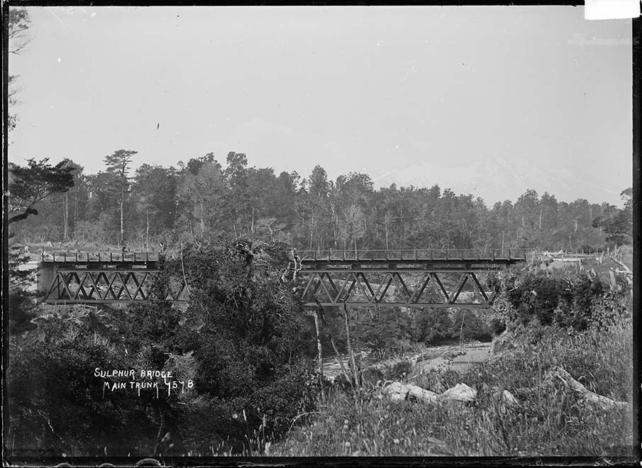
The Mangaturuturu Viaduct is situated between Horopito and Pokaka in the North Island's Central Plateau and is the highest railway structure above sea level in New Zealand. Constructed between 1907 and 1908, the viaduct was an integral part of the 'final push' to complete the NIMT, and by association was important to the settlement of the central North Island and the development of New Zealand's economy in the early-mid 20th century. The NIMT journey: The concept of the NIMT was promoted by Julius Vogel (1835-1899), then the Colonial Treasurer in William Fox's government, as part of his bold expansionist policy which was adopted by the House in 1870. From a purely practical standpoint, the NIMT was necessary because it established a direct transport route between New Zealand's two major cities, Auckland and Wellington. For the 20 years prior to the NIMT's completion, goods and passenger traffic between these cities was typically directed from Auckland to New Plymouth via coastal shipping and then continued by ship or train onto Wellington. This was by no means an ideal, or efficient, means of freight or passenger transport. However, the most direct route for this railway link was through the King Country. From the mid-1860s Maori in the central North Island had repelled European encroachment by establishing, and staunchly upholding, the restricted area known as the Rohe Potae, and the governments of the late 19th century saw the construction of the NIMT as a tool for gaining access to the King Country. In 1883, after a decade of persistent approaches from the government regarding the area, talks between officials and some King Country chiefs regarding the establishment of the railway through their land began in earnest. A series of rigorous negotiations was then initiated with two Ngati Maniapoto leaders, Wahanui Hautare and Rewi Maniapoto. There seems to have been a feeling that the railway and European incursion into the King Country was inevitable, but these chiefs wanted to make sure that it was on their terms. In late 1884 Wahanui announced his intention to cooperate with the government over the railway, and he laid out a set of conditions before the House of Representatives on 1 November 1884. The conditions included the right of the King movement to manage their own affairs, the banning of liquor from Waikato-Ngati Maniapoto territory, the right of his people to have sole responsibility for administering their ancestral lands, and that they were compensated for the land which was used. Following this, in early 1885 surveyors were allowed into the Rohe Potae to locate possible railway routes. Because of the tenuous relationship between the Crown and King Country iwi it was felt that the negotiation process was essential. However, by only consulting with Wahanui and Maniapoto the government purposely side-stepped King Tawhiao and other leaders who opposed the railway. Therefore, this initial agreement was not universal and accordingly there were instances of resistance, such as the destruction of surveying marks. Despite some opposition, surveying and construction plans continued and on 15 April 1885 it was Wahanui who wielded the shovel that turned the NIMT's first sod, which was then ceremonially wheeled away by Premier Robert Stout. Prior to the chiefs allowing surveyors into the Rohe Potae, possible railway corridors through the King Country were only speculative because there had not been any previous opportunity to map it in detail. There were several proposed routes for the NIMT and John Rochfort (1832-1893) surveyed for a possible corridor through the Central Plateau between 1883 and 1887. This was said to be his tour de force because he had to start from scratch and cover a large, and topographically complex, area. After much debate and delay it was Rochfort's route for the NIMT that was followed. The Maori land that this route required progressively passed into Crown ownership under the Public Works Acts of 1882 and 1894. This legislation stipulated that construction could not begin until the governor issued a proclamation detailing the middle-line that each successive section would take. Another key part of Vogel's scheme was to use the construction project as the basis for bringing thousands of assisted immigrants to New Zealand. His policy drew heavily on the model formulated in the United States of America, which used railways to gain access to previously remote areas, then to create settlements in these areas using the construction workers as the foundation of the local populous. The NIMT can be viewed as successful realisation of this model. It was also the catalyst for demographic change for the existing Maori population. In the Central Plateau Maori settlement was mostly concentrated around the Manganui-o-te-ao River. However, the NIMT caused a population shift, and by 1900 the various settlements around the river were largely depopulated because many inhabitants gained employment as labourers on the railway. Once construction was complete it appears that local Maori then gravitated toward the newly established NIMT towns. Therefore, the NIMT is responsible for radically changing the social landscape of the Central Plateau. The initial stages in NIMT history were protracted, and once the route was resolved and the required land obtained, the construction progress followed this early pattern and laboured along. The NIMT was eventually completed in 1908 having taken 23 years to complete due to various political and financial impediments including the economic depression of the 1890s. The slow progress bred public dissatisfaction and this had reached such a pitch by 1900 that it motivated parliament to inject significantly more money and manpower to the project in the hope that this would bring it to a quick resolution. This created a last flurry of activity which saw the remaining section between the Makohine Viaduct and Taumarunui completed in just six years. Within this area, the 'final push' and was no easy task, despite the increase in resources, because of its difficult geography which was noted for its steep grades, deep ravines, and heavy bush, not to mention the often inclement weather. Given the topography and the almost complete reliance on physical labour for construction, the completion of this section was relatively quick and remarkable. It also has many significant structures. These include the iconic Makatote and three other surviving viaducts, and important earthworks of which the Raurimu Spiral is an internationally recognised engineering achievement, as well as a number of other tunnels and smaller bridges. The Mangaturuturu and Makatote Viaducts are the only construction era viaducts in this area which remain a functioning part of the NIMT. The area north of Ohakune provided challenging obstacles for those designing and constructing the structures on the NIMT. The fact that the landscape would not yield willingly to a railway was widely recognised, and was acknowledged in newspapers during the 'final push': Both Mangaturuturu and Manganui, and Makatote as well, are deep mountain clefts formed in some convulsion of nature and the trachyte rocks bestew the beds of the torrents that run in the gorge-bottoms. High overhanging walls of embedded boulders look as if they are ready to fall on the head of the beholder, but the vegetation which partly wraps them proves that they have stood like this for generations. The challenges associated with navigating this landscape with a railway make the NIMT's ‘final push' section a recognised engineering achievement and one which concluded New Zealand's ‘pioneering bridge and railway building days...' Constructing the Mangaturuturu Viaduct: The Mangaturuturu Viaduct, and its other NIMT contemporaries, are products of the iron and steel construction age of the late 19th and early 20th centuries. The industrial revolution and resulting technologies, such as railways, demanded the development of construction materials which were long lasting, relatively light, and could be mass produced. Iron and steel fulfilled these criteria, but it was not until the late 19th century that a technique was developed which reduced the cost of steel production and made it as cost effective as iron. As a consequence of the international railway boom engineers, such as Eiffel, pioneered the construction of steel viaducts. From this period, steel fabrication was favoured for viaducts, and other large self-supporting structures. Lightness was particularly important for viaducts ‘because it is only in such structures that the weight of the metal forms a prominent item in the strains.' Although, not as monumental as the viaducts built by Eiffel, or even others on the NIMT like the Makatote, the Mangaturuturu Viaduct is representative of this trend. Years later in 1955 when the current highway bridge next to the viaduct was being planned, the District Commissioner of Works sited similar reasons for constructing that bridge using steel, and it was not until after this period that construction using prestressed concrete became a predominant material for bridges in New Zealand. The engineer responsible for designing the Mangaturuturu Viaduct, and many other ‘final push' structures, was Peter Seton Hay. Hay is noteworthy because he was the first person to graduate from the University of Otago with a Bachelor of Arts in 1877. He then joined the Public Works Department (PWD) and gradually progressed through its ranks to become the engineer-in-chief by the time he died prematurely in 1907. Hay's designs for the Makohine, Mangaweka, Hapuawhenua, Taonui, Mangaturuturu, Manganui-o-te-ao, and Makatote viaducts were all based on classic North American trestle viaducts and are recognised, alongside his pioneering research into New Zealand's hydroelectric capabilities, as his most important legacies. The Mangaturuturu Viaduct and the original Manganui-o-te-ao Viaduct were closely related in design, as they were both two span steel Warren truss bridges with a central concrete pier. They were also a similar length with the Mangaturuturu being 196ft (60m) and the Manganui-o-te-ao 224ft (68m), although at 60 ft (18m) tall, Mangaturuturu was shorter than its counterpart. Mangaturuturu and, while it survived, Manganui-o-te-ao were always dwarfed by their spectacular sibling, the Makatote Viaduct. However, in general the Mangaturuturu Viaduct's height and length make it a representative NIMT bridge. The Manganui-o-te-ao Viaduct was replaced in 1967 and therefore the Mangaturuturu Viaduct is the only noted remaining Hay viaduct of this design on the NIMT. The Mangaturuturu Viaduct was designed and partially constructed by the PWD. At both Mangaturuturu and the nearby Manganui-o-te-ao Viaduct, the Department was responsible for constructing the concrete piers and abutments. At Mangaturuturu they had completed this by mid-1907. However, the superstructure was manufactured and constructed by J & A Andersons Ltd of Christchurch who were awarded the contract in 1906. Andersons was a well established firm, and had constructed railways and viaducts in the South Island, and also on the NIMT having built the Te Kuiti to Mokau section (1887-89) which included the Waiteti Viaduct. Despite this experience, Andersons were primarily given the contract because of the close proximity of their Makatote workshop and its ability to produce the steelwork at a time when it was impossible for the PWD workshop at Mangaonoho to do so because it was backed-up manufacturing the steelwork for the Hapuawhenua and Taonui viaducts. Despite the foundation work being completed by the PWD in a timely manner, the Mangaturuturu Viaduct was not completed until mid-1908 because apparently there were not enough workers available. This was because the main construction focus of the area was on completing the nearby, and well behind schedule, Makatote Viaduct. This diversion of resources meant that the Mangaturuturu contract ran six months overtime and was completed only one month prior to the ‘Parliamentary Special' journey at the beginning of August: the first through trip from Wellington to Auckland. Despite this it was still finished before the Makatote Viaduct and just before the Manganui-o-te-ao. Even when workers were available, the altitude of the viaduct would have inhibited progress. The work environment at the Mangaturuturu Viaduct site was described as such: So little sun comes here that the ground is hard and frost-bound all day, and it is even colder than on the snow-clad slope of Waiouru and Turangarere. Yet men must toil here, napping stones and mixing concrete, and praying for the advent of summer. The inclemency of the local climate and the problems this posed in terms of working conditions and worker health is demonstrated by the fact that Hay is said to have made only one visit to the construction sites around Mangaturuturu while taking a general tour of the works in the area, and it was on this trip that he contracted the pneumonia which caused his death in March 1907. Consequently, Hay did not live to see the last three viaducts he designed come to fruition and was acknowledged posthumously for his central role in the successful completion of the NIMT. Even with the Mangaturuturu Viaduct's high elevation the workers at the site typically slept in tents which were standard issue along with a pick, long handled shovel, and an axe; the hand tools responsible for building most of the NIMT. Due to Mangaturuturu being a smaller scale project it was not necessary to employ the same innovative machine-powered techniques that were employed in the construction of the Makatote Viaduct, and therefore manual labour prevailed. Because of its similar size, and because the superstructure construction was contracted to the same company, it is probable that the Mangaturuturu was constructed in the same manner as Manganui-o-te-ao Viaduct. This was done by building a temporary timber skeletal scaffold between the central and flanking piers that had a wooden support at the top to hold the prefabricated components of the spans as they were assembled in situ. Therefore, it is largely due to manual brawn and forbearance that structures like the Mangaturuturu, and the NIMT in general, were constructed. The completion of the NIMT in late 1908 is described as ‘...one of the pivotal moments in New Zealand history' and ‘...arguably the New Zealand state's greatest achievement, at least in the first century after 1840, and certainly its greatest financial commitment.' Upon its completion the NIMT revolutionised passenger and freight transport in the North Island and directly influenced the development of New Zealand's economy in the first half of the 20th century. Vogel's strategy for gaining access to, and promoting settlement in, previously remote regions was a resounding success. In this respect ‘final push' structures, such as the Mangaturuturu Viaduct, are notable contributors to New Zealand history. Still standing: the Mangaturuturu post-construction: Railway structures, like the Mangaturuturu Viaduct, were built and operated based around the principle of continuous improvement and repair. Therefore, additions and alterations to the viaduct were an integral part of its, and the NIMT's, story and reflect larger historical changes in railway operations and technology. For example, along with other bridges and viaducts on the NIMT, the Mangaturuturu would have had its spans strengthened between 1925 and 1932 to ensure it could bear the heavier class of locomotive that was being introduced. This and some other changes to the viaduct were dictated by technological developments, but attention to the structure was also a result of its connection to the active volcano, Mount Ruapehu. Rail transport was the main means of passenger and freight traffic within New Zealand for the first half of the 20th century. However, by the 50th anniversary of the completion of the NIMT, the pre-eminence of rail was being challenged and was eventually overtaken by road transport. This focus on road building is demonstrated by the fact that it was estimated in the mid-1960s that the opening of one road bridge per day was needed to keep up with demand. Therefore, it is no surprise that in the late 1950s a highway bridge was built parallel to the Mangaturuturu Viaduct. The close positioning of the bridge resulted because encroachment on the railway reserve reduced the amount of unused land between the two structures and presumably this also meant a smaller area of land that the PWD had to acquisition for the bridge and adjoining road. Another affect of the closeness of the road bridge was to diminish the visual impact of the viaduct. However, it did also afford easy viewing access of the viaducts features, such as the girders, which is impossible at larger structures such as the Makatote Viaduct. Over the years the Mangaturuturu River and Viaduct's proximity to Mount Ruapehu has been cause for concern, particularly after the 1953 Tangiwai Disaster. This tragedy was New Zealand's worst rail disaster and was the result of a lahar knocking down the central concrete piers of the Whangaehu River Rail Bridge. In an attempt to minimise the risk of a repeat of the Tangiwai Disaster, a thorough analysis of the structural integrity and foundations of bridges and viaducts which crossed rivers running down from Mount Ruapehu was undertaken over the few years after the tragedy. The analysis of the foundations of the Mangaturuturu Viaduct's pier in 1956 was driven by the Tangiwai Disaster and given particular emphasis because of the river's link to Mount Ruapehu and its history of being affected by volcanic activity. At the time the Mangaturuturu Viaduct was constructed, the Mangaturuturu River was also known as Sulphur River or Creek. It was reported that the water was ‘heavily impregnated with sulphur' and it was common knowledge that horses were not to be watered there. It is uncertain when and what event caused the sulphur levels in the river, so it is correspondingly unclear whether it affected Maori settlements during the 19th century which were concentrated around the Manganui-o-te-ao River that the Mangaturuturu River leads into, or if it discouraged them from using the river and its resources. By 1912 the water was reported to have cleared, but the memory of this was the foundation of concern that the viaduct could be threatened by a lahar. The conclusion drawn from the analysis of the viaduct's foundations was that the structure had not been adversely affected by any volcanic activity in the 50 years since it was constructed and that it was not at risk of failure, in a normal flood at least. However, this was contradicted in 1969 when another report was sparked by an upsurge in volcanic activity on Mount Ruapehu. This found that the depth of the original foundation was insufficient which, in the engineer's opinion, left it susceptible to a ‘Tangiwai type washout.' The direct result of this was that the viaduct was underpinned in 1970-71. This remedial work proved timely and fortunate because in late April 1975 a lahar swept down the Mangaturuturu River. This event caused severe scouring in the river bed with the flow being 7ft (2.1m) above flood level and it also changed the course of the river. The torrent uplifted the central pier of the old highway bridge upstream, which weighed approximately 80 tonnes, and hurtled it downstream depositing it against the viaduct's central concrete pier. This was lucky because, while the viaduct incurred no serious damage, if the concrete slab had continued on and hit the new highway bridge's steel pier its speed and weight would have caused serious structural damage to the bridge, if the not complete failure. Unlike the highway bridge, the viaduct did not require further underpinning as a result of the lahar and the old highway bridge's pier was removed in 1976. Perhaps the most significant change in the operation and appearance of the NIMT over time was the electrification of the railway in the late 1980s. In preparation a comprehensive upgrading programme was initiated which included the strengthening of older bridges so that they could bear the new Class 30 locomotives which were to be introduced, and also the installing of electrification masts along the length of the NIMT. Subsequently the Mangaturuturu underwent changes at this time which reflect this event in the NIMT's history. These alterations and additions included the replacing of the ironbark railbeams with steel equivalents, and the addition of the electrification mast and parapet, or railing, between 1986 and 1987. The longevity of the Mangaturuturu Viaduct is a tribute to the skill of the designer, the contractor, and the workers who constructed it. On at least one occasion the Railways Department undertook a systematic assessment of the structures on the NIMT which resulted in some being replaced because, unlike Mangaturuturu, they could not be upgraded in step with changes in locomotives, or because age meant that replacement was necessary for safety. This is emphasised by the fact that only 23% of bridges and viaducts still used in New Zealand's rail network are over 90 years old. However, many of the older structures still in use are subject to speed restrictions. The Mangaturuturu Viaduct had a speed restriction in place in 2004 because faults were found with the steel railbeam to diaphragm connections, even though these railbeams had only replaced a few decades earlier. This temporary speed restriction was lifted when the problematic areas were fixed. Therefore, the Mangaturuturu Viaduct is currently statistically exceptional for its age, due to the design and technical skill exhibited during its construction, but also because of the ongoing maintenance of the structure.
The Mangaturuturu Viaduct is situated between Horopito and Pokaka in the North Island's Central Plateau and is the highest railway structure above sea level in New Zealand. Constructed between 1907 and 1908, the viaduct was an integral part of the 'final push' to complete the NIMT, and by association was important to the settlement of the central North Island and the development of New Zealand's economy in the early-mid 20th century. The NIMT journey: The concept of the NIMT was promoted by Julius Vogel (1835-1899), then the Colonial Treasurer in William Fox's government, as part of his bold expansionist policy which was adopted by the House in 1870. From a purely practical standpoint, the NIMT was necessary because it established a direct transport route between New Zealand's two major cities, Auckland and Wellington. For the 20 years prior to the NIMT's completion, goods and passenger traffic between these cities was typically directed from Auckland to New Plymouth via coastal shipping and then continued by ship or train onto Wellington. This was by no means an ideal, or efficient, means of freight or passenger transport. However, the most direct route for this railway link was through the King Country. From the mid-1860s Maori in the central North Island had repelled European encroachment by establishing, and staunchly upholding, the restricted area known as the Rohe Potae, and the governments of the late 19th century saw the construction of the NIMT as a tool for gaining access to the King Country. In 1883, after a decade of persistent approaches from the government regarding the area, talks between officials and some King Country chiefs regarding the establishment of the railway through their land began in earnest. A series of rigorous negotiations was then initiated with two Ngati Maniapoto leaders, Wahanui Hautare and Rewi Maniapoto. There seems to have been a feeling that the railway and European incursion into the King Country was inevitable, but these chiefs wanted to make sure that it was on their terms. In late 1884 Wahanui announced his intention to cooperate with the government over the railway, and he laid out a set of conditions before the House of Representatives on 1 November 1884. The conditions included the right of the King movement to manage their own affairs, the banning of liquor from Waikato-Ngati Maniapoto territory, the right of his people to have sole responsibility for administering their ancestral lands, and that they were compensated for the land which was used. Following this, in early 1885 surveyors were allowed into the Rohe Potae to locate possible railway routes. Because of the tenuous relationship between the Crown and King Country iwi it was felt that the negotiation process was essential. However, by only consulting with Wahanui and Maniapoto the government purposely side-stepped King Tawhiao and other leaders who opposed the railway. Therefore, this initial agreement was not universal and accordingly there were instances of resistance, such as the destruction of surveying marks. Despite some opposition, surveying and construction plans continued and on 15 April 1885 it was Wahanui who wielded the shovel that turned the NIMT's first sod, which was then ceremonially wheeled away by Premier Robert Stout. Prior to the chiefs allowing surveyors into the Rohe Potae, possible railway corridors through the King Country were only speculative because there had not been any previous opportunity to map it in detail. There were several proposed routes for the NIMT and John Rochfort (1832-1893) surveyed for a possible corridor through the Central Plateau between 1883 and 1887. This was said to be his tour de force because he had to start from scratch and cover a large, and topographically complex, area. After much debate and delay it was Rochfort's route for the NIMT that was followed. The Maori land that this route required progressively passed into Crown ownership under the Public Works Acts of 1882 and 1894. This legislation stipulated that construction could not begin until the governor issued a proclamation detailing the middle-line that each successive section would take. Another key part of Vogel's scheme was to use the construction project as the basis for bringing thousands of assisted immigrants to New Zealand. His policy drew heavily on the model formulated in the United States of America, which used railways to gain access to previously remote areas, then to create settlements in these areas using the construction workers as the foundation of the local populous. The NIMT can be viewed as successful realisation of this model. It was also the catalyst for demographic change for the existing Maori population. In the Central Plateau Maori settlement was mostly concentrated around the Manganui-o-te-ao River. However, the NIMT caused a population shift, and by 1900 the various settlements around the river were largely depopulated because many inhabitants gained employment as labourers on the railway. Once construction was complete it appears that local Maori then gravitated toward the newly established NIMT towns. Therefore, the NIMT is responsible for radically changing the social landscape of the Central Plateau. The initial stages in NIMT history were protracted, and once the route was resolved and the required land obtained, the construction progress followed this early pattern and laboured along. The NIMT was eventually completed in 1908 having taken 23 years to complete due to various political and financial impediments including the economic depression of the 1890s. The slow progress bred public dissatisfaction and this had reached such a pitch by 1900 that it motivated parliament to inject significantly more money and manpower to the project in the hope that this would bring it to a quick resolution. This created a last flurry of activity which saw the remaining section between the Makohine Viaduct and Taumarunui completed in just six years. Within this area, the 'final push' and was no easy task, despite the increase in resources, because of its difficult geography which was noted for its steep grades, deep ravines, and heavy bush, not to mention the often inclement weather. Given the topography and the almost complete reliance on physical labour for construction, the completion of this section was relatively quick and remarkable. It also has many significant structures. These include the iconic Makatote and three other surviving viaducts, and important earthworks of which the Raurimu Spiral is an internationally recognised engineering achievement, as well as a number of other tunnels and smaller bridges. The Mangaturuturu and Makatote Viaducts are the only construction era viaducts in this area which remain a functioning part of the NIMT. The area north of Ohakune provided challenging obstacles for those designing and constructing the structures on the NIMT. The fact that the landscape would not yield willingly to a railway was widely recognised, and was acknowledged in newspapers during the 'final push': Both Mangaturuturu and Manganui, and Makatote as well, are deep mountain clefts formed in some convulsion of nature and the trachyte rocks bestew the beds of the torrents that run in the gorge-bottoms. High overhanging walls of embedded boulders look as if they are ready to fall on the head of the beholder, but the vegetation which partly wraps them proves that they have stood like this for generations. The challenges associated with navigating this landscape with a railway make the NIMT's ‘final push' section a recognised engineering achievement and one which concluded New Zealand's ‘pioneering bridge and railway building days...' Constructing the Mangaturuturu Viaduct: The Mangaturuturu Viaduct, and its other NIMT contemporaries, are products of the iron and steel construction age of the late 19th and early 20th centuries. The industrial revolution and resulting technologies, such as railways, demanded the development of construction materials which were long lasting, relatively light, and could be mass produced. Iron and steel fulfilled these criteria, but it was not until the late 19th century that a technique was developed which reduced the cost of steel production and made it as cost effective as iron. As a consequence of the international railway boom engineers, such as Eiffel, pioneered the construction of steel viaducts. From this period, steel fabrication was favoured for viaducts, and other large self-supporting structures. Lightness was particularly important for viaducts ‘because it is only in such structures that the weight of the metal forms a prominent item in the strains.' Although, not as monumental as the viaducts built by Eiffel, or even others on the NIMT like the Makatote, the Mangaturuturu Viaduct is representative of this trend. Years later in 1955 when the current highway bridge next to the viaduct was being planned, the District Commissioner of Works sited similar reasons for constructing that bridge using steel, and it was not until after this period that construction using prestressed concrete became a predominant material for bridges in New Zealand. The engineer responsible for designing the Mangaturuturu Viaduct, and many other ‘final push' structures, was Peter Seton Hay. Hay is noteworthy because he was the first person to graduate from the University of Otago with a Bachelor of Arts in 1877. He then joined the Public Works Department (PWD) and gradually progressed through its ranks to become the engineer-in-chief by the time he died prematurely in 1907. Hay's designs for the Makohine, Mangaweka, Hapuawhenua, Taonui, Mangaturuturu, Manganui-o-te-ao, and Makatote viaducts were all based on classic North American trestle viaducts and are recognised, alongside his pioneering research into New Zealand's hydroelectric capabilities, as his most important legacies. The Mangaturuturu Viaduct and the original Manganui-o-te-ao Viaduct were closely related in design, as they were both two span steel Warren truss bridges with a central concrete pier. They were also a similar length with the Mangaturuturu being 196ft (60m) and the Manganui-o-te-ao 224ft (68m), although at 60 ft (18m) tall, Mangaturuturu was shorter than its counterpart. Mangaturuturu and, while it survived, Manganui-o-te-ao were always dwarfed by their spectacular sibling, the Makatote Viaduct. However, in general the Mangaturuturu Viaduct's height and length make it a representative NIMT bridge. The Manganui-o-te-ao Viaduct was replaced in 1967 and therefore the Mangaturuturu Viaduct is the only noted remaining Hay viaduct of this design on the NIMT. The Mangaturuturu Viaduct was designed and partially constructed by the PWD. At both Mangaturuturu and the nearby Manganui-o-te-ao Viaduct, the Department was responsible for constructing the concrete piers and abutments. At Mangaturuturu they had completed this by mid-1907. However, the superstructure was manufactured and constructed by J & A Andersons Ltd of Christchurch who were awarded the contract in 1906. Andersons was a well established firm, and had constructed railways and viaducts in the South Island, and also on the NIMT having built the Te Kuiti to Mokau section (1887-89) which included the Waiteti Viaduct. Despite this experience, Andersons were primarily given the contract because of the close proximity of their Makatote workshop and its ability to produce the steelwork at a time when it was impossible for the PWD workshop at Mangaonoho to do so because it was backed-up manufacturing the steelwork for the Hapuawhenua and Taonui viaducts. Despite the foundation work being completed by the PWD in a timely manner, the Mangaturuturu Viaduct was not completed until mid-1908 because apparently there were not enough workers available. This was because the main construction focus of the area was on completing the nearby, and well behind schedule, Makatote Viaduct. This diversion of resources meant that the Mangaturuturu contract ran six months overtime and was completed only one month prior to the ‘Parliamentary Special' journey at the beginning of August: the first through trip from Wellington to Auckland. Despite this it was still finished before the Makatote Viaduct and just before the Manganui-o-te-ao. Even when workers were available, the altitude of the viaduct would have inhibited progress. The work environment at the Mangaturuturu Viaduct site was described as such: So little sun comes here that the ground is hard and frost-bound all day, and it is even colder than on the snow-clad slope of Waiouru and Turangarere. Yet men must toil here, napping stones and mixing concrete, and praying for the advent of summer. The inclemency of the local climate and the problems this posed in terms of working conditions and worker health is demonstrated by the fact that Hay is said to have made only one visit to the construction sites around Mangaturuturu while taking a general tour of the works in the area, and it was on this trip that he contracted the pneumonia which caused his death in March 1907. Consequently, Hay did not live to see the last three viaducts he designed come to fruition and was acknowledged posthumously for his central role in the successful completion of the NIMT. Even with the Mangaturuturu Viaduct's high elevation the workers at the site typically slept in tents which were standard issue along with a pick, long handled shovel, and an axe; the hand tools responsible for building most of the NIMT. Due to Mangaturuturu being a smaller scale project it was not necessary to employ the same innovative machine-powered techniques that were employed in the construction of the Makatote Viaduct, and therefore manual labour prevailed. Because of its similar size, and because the superstructure construction was contracted to the same company, it is probable that the Mangaturuturu was constructed in the same manner as Manganui-o-te-ao Viaduct. This was done by building a temporary timber skeletal scaffold between the central and flanking piers that had a wooden support at the top to hold the prefabricated components of the spans as they were assembled in situ. Therefore, it is largely due to manual brawn and forbearance that structures like the Mangaturuturu, and the NIMT in general, were constructed. The completion of the NIMT in late 1908 is described as ‘...one of the pivotal moments in New Zealand history' and ‘...arguably the New Zealand state's greatest achievement, at least in the first century after 1840, and certainly its greatest financial commitment.' Upon its completion the NIMT revolutionised passenger and freight transport in the North Island and directly influenced the development of New Zealand's economy in the first half of the 20th century. Vogel's strategy for gaining access to, and promoting settlement in, previously remote regions was a resounding success. In this respect ‘final push' structures, such as the Mangaturuturu Viaduct, are notable contributors to New Zealand history. Still standing: the Mangaturuturu post-construction: Railway structures, like the Mangaturuturu Viaduct, were built and operated based around the principle of continuous improvement and repair. Therefore, additions and alterations to the viaduct were an integral part of its, and the NIMT's, story and reflect larger historical changes in railway operations and technology. For example, along with other bridges and viaducts on the NIMT, the Mangaturuturu would have had its spans strengthened between 1925 and 1932 to ensure it could bear the heavier class of locomotive that was being introduced. This and some other changes to the viaduct were dictated by technological developments, but attention to the structure was also a result of its connection to the active volcano, Mount Ruapehu. Rail transport was the main means of passenger and freight traffic within New Zealand for the first half of the 20th century. However, by the 50th anniversary of the completion of the NIMT, the pre-eminence of rail was being challenged and was eventually overtaken by road transport. This focus on road building is demonstrated by the fact that it was estimated in the mid-1960s that the opening of one road bridge per day was needed to keep up with demand. Therefore, it is no surprise that in the late 1950s a highway bridge was built parallel to the Mangaturuturu Viaduct. The close positioning of the bridge resulted because encroachment on the railway reserve reduced the amount of unused land between the two structures and presumably this also meant a smaller area of land that the PWD had to acquisition for the bridge and adjoining road. Another affect of the closeness of the road bridge was to diminish the visual impact of the viaduct. However, it did also afford easy viewing access of the viaducts features, such as the girders, which is impossible at larger structures such as the Makatote Viaduct. Over the years the Mangaturuturu River and Viaduct's proximity to Mount Ruapehu has been cause for concern, particularly after the 1953 Tangiwai Disaster. This tragedy was New Zealand's worst rail disaster and was the result of a lahar knocking down the central concrete piers of the Whangaehu River Rail Bridge. In an attempt to minimise the risk of a repeat of the Tangiwai Disaster, a thorough analysis of the structural integrity and foundations of bridges and viaducts which crossed rivers running down from Mount Ruapehu was undertaken over the few years after the tragedy. The analysis of the foundations of the Mangaturuturu Viaduct's pier in 1956 was driven by the Tangiwai Disaster and given particular emphasis because of the river's link to Mount Ruapehu and its history of being affected by volcanic activity. At the time the Mangaturuturu Viaduct was constructed, the Mangaturuturu River was also known as Sulphur River or Creek. It was reported that the water was ‘heavily impregnated with sulphur' and it was common knowledge that horses were not to be watered there. It is uncertain when and what event caused the sulphur levels in the river, so it is correspondingly unclear whether it affected Maori settlements during the 19th century which were concentrated around the Manganui-o-te-ao River that the Mangaturuturu River leads into, or if it discouraged them from using the river and its resources. By 1912 the water was reported to have cleared, but the memory of this was the foundation of concern that the viaduct could be threatened by a lahar. The conclusion drawn from the analysis of the viaduct's foundations was that the structure had not been adversely affected by any volcanic activity in the 50 years since it was constructed and that it was not at risk of failure, in a normal flood at least. However, this was contradicted in 1969 when another report was sparked by an upsurge in volcanic activity on Mount Ruapehu. This found that the depth of the original foundation was insufficient which, in the engineer's opinion, left it susceptible to a ‘Tangiwai type washout.' The direct result of this was that the viaduct was underpinned in 1970-71. This remedial work proved timely and fortunate because in late April 1975 a lahar swept down the Mangaturuturu River. This event caused severe scouring in the river bed with the flow being 7ft (2.1m) above flood level and it also changed the course of the river. The torrent uplifted the central pier of the old highway bridge upstream, which weighed approximately 80 tonnes, and hurtled it downstream depositing it against the viaduct's central concrete pier. This was lucky because, while the viaduct incurred no serious damage, if the concrete slab had continued on and hit the new highway bridge's steel pier its speed and weight would have caused serious structural damage to the bridge, if the not complete failure. Unlike the highway bridge, the viaduct did not require further underpinning as a result of the lahar and the old highway bridge's pier was removed in 1976. Perhaps the most significant change in the operation and appearance of the NIMT over time was the electrification of the railway in the late 1980s. In preparation a comprehensive upgrading programme was initiated which included the strengthening of older bridges so that they could bear the new Class 30 locomotives which were to be introduced, and also the installing of electrification masts along the length of the NIMT. Subsequently the Mangaturuturu underwent changes at this time which reflect this event in the NIMT's history. These alterations and additions included the replacing of the ironbark railbeams with steel equivalents, and the addition of the electrification mast and parapet, or railing, between 1986 and 1987. The longevity of the Mangaturuturu Viaduct is a tribute to the skill of the designer, the contractor, and the workers who constructed it. On at least one occasion the Railways Department undertook a systematic assessment of the structures on the NIMT which resulted in some being replaced because, unlike Mangaturuturu, they could not be upgraded in step with changes in locomotives, or because age meant that replacement was necessary for safety. This is emphasised by the fact that only 23% of bridges and viaducts still used in New Zealand's rail network are over 90 years old. However, many of the older structures still in use are subject to speed restrictions. The Mangaturuturu Viaduct had a speed restriction in place in 2004 because faults were found with the steel railbeam to diaphragm connections, even though these railbeams had only replaced a few decades earlier. This temporary speed restriction was lifted when the problematic areas were fixed. Therefore, the Mangaturuturu Viaduct is currently statistically exceptional for its age, due to the design and technical skill exhibited during its construction, but also because of the ongoing maintenance of the structure.
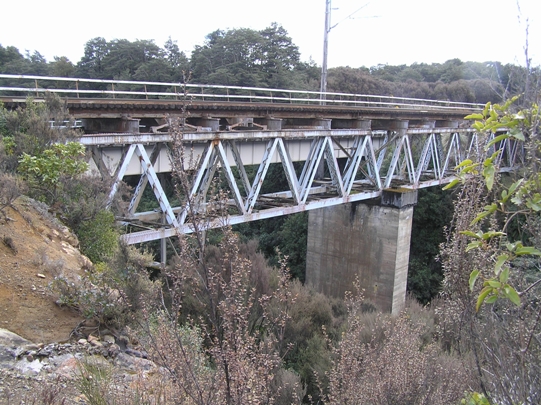
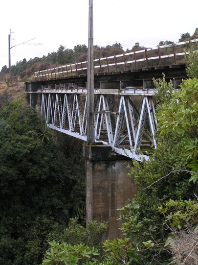
Physical Description and Analysis: The Mangaturuturu Viaduct is a truss viaduct consisting of two 98ft (30m) deck type Warren trusses which have lateral bracing at the ends of the chords and end struts. This superstructure is predominantly constructed from steel, but has a 60 ft (18m) central mass concrete pier as well as two small mass concrete flanking piers and mass concrete abutments. The viaduct is a level structure which spans the Mangaturuturu River gorge in a straight line. There have been a series of changes to the viaduct's fabric and appearance. The first of these was the strengthening project in the late 1920s with the strengthening of the spans. Other additions include the construction of the electrification mast and parapet in the late 1980s, and the floorbeams were straightened in 2005. The railbeam diaphragms which were installed in 1987 had to be replaced c.2008 because they were causing the railbeams to crack or fail. Therefore, most of the changes to the structure, carried out as routine maintenance and operationally necessitated additions, have been to the deck area. However, some removal of construction era fabric has occurred with the upgrading of the 1908 timber railbeams in the late 1950s, and subsequently those beams were replaced in 1987 as part of the preparation for the electrification of the NIMT. The bedplates were changed at the same time as the first railbeam replacement and a few years later the original, or at least early period, bolts were also renewed. Another loss of 1907 fabric happened in 1970-71 during the underpinning of the viaduct, which meant that some fabric was removed from the interior of the central concrete pier. However, this removal of original and insertion of new fabric is indistinguishable from the exterior and was vital for the ongoing integrity of the structure. The Mangaturuturu Viaduct has a significant amount of NIMT construction era fabric remaining. However, its appearance is noticeably different from that of 1908. The additions and upgrades have been necessary to ensure that the viaduct continued to be a functioning aspect of the NIMT when changes in operational practices dictated, when wear meant remedial work was essential in maintaining the integrity and viability of the structure, or as a risk management measure.
Physical Description and Analysis: The Mangaturuturu Viaduct is a truss viaduct consisting of two 98ft (30m) deck type Warren trusses which have lateral bracing at the ends of the chords and end struts. This superstructure is predominantly constructed from steel, but has a 60 ft (18m) central mass concrete pier as well as two small mass concrete flanking piers and mass concrete abutments. The viaduct is a level structure which spans the Mangaturuturu River gorge in a straight line. There have been a series of changes to the viaduct's fabric and appearance. The first of these was the strengthening project in the late 1920s with the strengthening of the spans. Other additions include the construction of the electrification mast and parapet in the late 1980s, and the floorbeams were straightened in 2005. The railbeam diaphragms which were installed in 1987 had to be replaced c.2008 because they were causing the railbeams to crack or fail. Therefore, most of the changes to the structure, carried out as routine maintenance and operationally necessitated additions, have been to the deck area. However, some removal of construction era fabric has occurred with the upgrading of the 1908 timber railbeams in the late 1950s, and subsequently those beams were replaced in 1987 as part of the preparation for the electrification of the NIMT. The bedplates were changed at the same time as the first railbeam replacement and a few years later the original, or at least early period, bolts were also renewed. Another loss of 1907 fabric happened in 1970-71 during the underpinning of the viaduct, which meant that some fabric was removed from the interior of the central concrete pier. However, this removal of original and insertion of new fabric is indistinguishable from the exterior and was vital for the ongoing integrity of the structure. The Mangaturuturu Viaduct has a significant amount of NIMT construction era fabric remaining. However, its appearance is noticeably different from that of 1908. The additions and upgrades have been necessary to ensure that the viaduct continued to be a functioning aspect of the NIMT when changes in operational practices dictated, when wear meant remedial work was essential in maintaining the integrity and viability of the structure, or as a risk management measure.
Historical and Associated Iwi / Hapū / Whānau
Completion Date
25th January 2009
Report Written By
Karen Astwood
Information Sources
Appendices to the Journals of the House of Representatives (AJHR)
Appendices to the Journals of the House of Representatives
Alexander Turnbull Library
Alexander Turnbull Library, Wellington
Archives New Zealand (Wgtn)
Archives New Zealand (Wellington)
Dictionary of New Zealand Biography
Dictionary of New Zealand Biography
Evening Post
Evening Post, 27 Jun 1919, p.7.
New Zealand Historic Places Trust (NZHPT)
New Zealand Historic Places Trust
Otago Witness
Otago Witness
Waitangi Tribunal
Waitangi Tribunal Report, www.waitangi-tribunal.govt.nz
ONTRACK
ONTRACK Wellington
Other Information
This structure forms part of the operational railway. Trespassing on the rail premises and/or rail infrastructure is prohibited as trains may pass at any time without warning. Pursuant to the Railways Act 2005, a person must not enter any railway infrastructure or any railway premises without first obtaining a formal written Permit to Enter from the rail premises or access provider. A fully referenced Registration report is available from the NZHPT Central region office. Please note that entry on the New Zealand Heritage List/Rarangi Korero identifies only the heritage values of the property concerned, and should not be construed as advice on the state of the property, or as a comment of its soundness or safety, including in regard to earthquake risk, safety in the event of fire, or insanitary conditions.
Current Usages
Uses: Transport
Specific Usage: Bridge/ Viaduct
Former Usages
General Usage: Transport
Specific Usage: Bridge/ Viaduct
Themes
North Island Main Trunk Line
Current Usages
Uses: Transport
Specific Usage: Bridge/ Viaduct
Former Usages
General Usage: Transport
Specific Usage: Bridge/ Viaduct
Themes
North Island Main Trunk Line
Location
Related listings
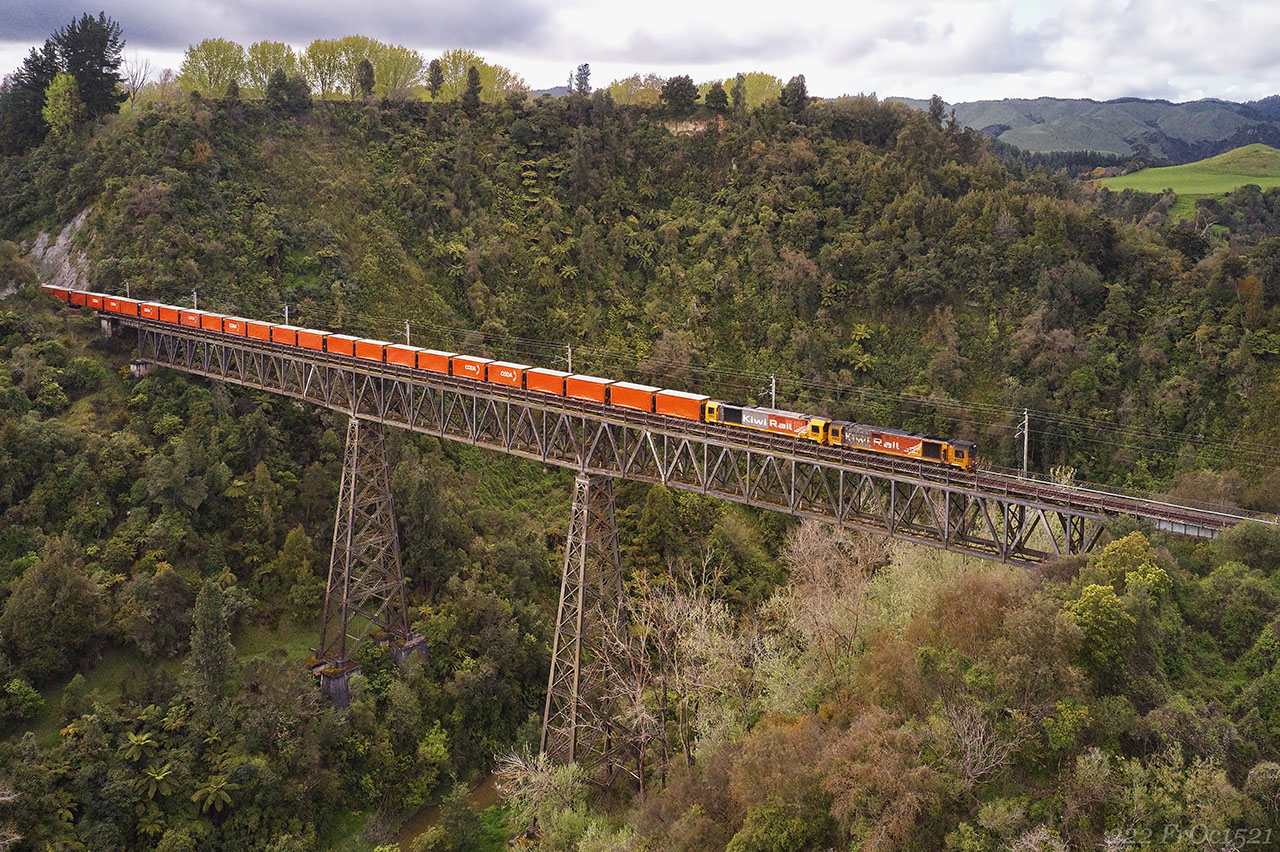
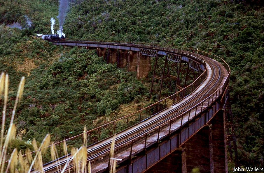
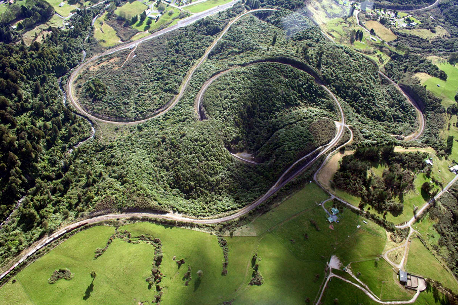
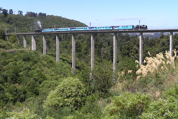
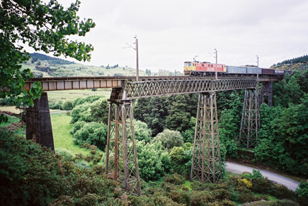
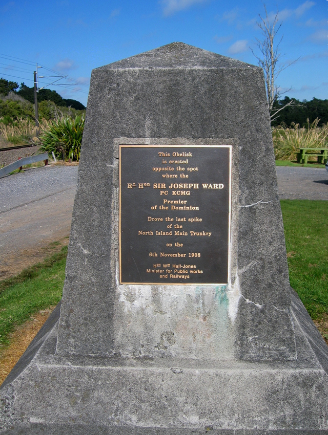
Sign up to hear more
Get the latest heritage news, features and events delivered
straight to your inbox.
