

The NIMT has had a profound effect on New Zealand history. The construction effort saw a dramatic change in the social make-up of the King Country in particular, and has had a lasting political legacy for race relations. The railway itself not only spectacularly altered the landscape but also enabled industry and farming into the area, which led to deforestation and made the presence of the Tongariro National Park and the establishment of scenic reserves along the railway all the more important. The dramatic features of this landscape contributed to the central section of the NIMT being considered the aesthetic highlight of the railway. After its completion the railway became essential to the economy of New Zealand as an important infrastructure asset for freight transportation. As the main means of passenger transportation in the North Island for the greater part of the 20th century for everyone from the shoppers in the small towns dotting the railway to holidaying families, to military personnel and dignitaries, the NIMT was also a strong cultural entity nationally.
The construction of the NIMT was completed in 1908 after the 23 year project to complete the central section, a time span which could have been significantly longer had it not been for a determined effort at the turn of the 20th century. An increased investment of resources to overcome the hurdle of the Makohine Viaduct, and to also push further into the King Country from the north, saw a final flurry of activity. Therefore, once the Makohine Viaduct was completed it only took a further six years to build the NIMT over the approximately 200km gap between the railheads; the most difficult landscape the engineers and construction teams had encountered thus far. The complexity of the landscape meant that this central portion of the NIMT had a concentration of engineering feats including the Raurimu Spiral, and the Hapuawhenua, Makatote, Makohine and Mangaweka Viaducts.
Throughout its history the form of this final NIMT section has largely remained true to that of 1908, although some significant deviations built in preparation for the electrification of the line in the late 20th century altered it. However, despite bypassing sizable areas of NIMT construction era activity these deviations have added to the engineering reputation of the central portion of the NIMT. Within the larger recognised engineering feat of the entire NIMT, this section features the majority of the significant structures and sites on the railway, as well as a collection of representative examples of railway engineering spanning the 20th century.
List Entry Information
Status
Listed
List Entry Status
Historic Area
Access
Private/No Public Access
List Number
7793
Date Entered
26th June 2009
Date of Effect
26th June 2009
City/District Council
Ruapehu District,Rangitīkei District
Region
Horizons (Manawatū-Whanganui) Region
Extent of List Entry
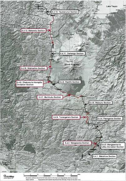
Extent includes the land in the NIMT rail corridor from the Makohine Viaduct to the Taumarunui Railway Station (inclusive), as well as large sections of ex-NIMT rail corridor land within these bounds and the areas described as the 'Last Spike' Memorial, Ohakune to Horopito Coach Road, Ohakune Railway Station and Signal Box, and Tangiwai Memorial Reserve, and the NIMT and its associated structures thereon. (Refer to maps in Appendix 1 of the registration report, and 4 in Vol. II and Vol. III for further information).. Land included in the Registration This NIMT Historic Area covers a long and narrow area defined by the past and present designated NIMT railway corridors within the thematic physical southern and northern boundaries of the Makohine Viaduct and Taumarunui Railway Station. The land in the area also includes recognised NIMT related places which are not part of the railway corridor, but are immediately adjacent to it, such as the land incorporated in the extents of the two commemorative sites and the Ohakune to Horopito Coach Road. It is important to acknowledge the vast range of places on or directly related to the NIMT between Wellington and Auckland which for thematic reasons are external to the land and sites included in this historic area. For instance, none of the 'railway towns' with their collections of railway worker cottages, or the many private sidings which branch from the NIMT, have been included in the area's extent despite the contribution they could make to a holistic history of the NIMT and its effects. Places of note external to the extent of the area or theme have been listed in a file note. Relationship between Historic Places These places are NIMT construction era sites or are places subsequently constructed which are, or were, part of the functioning central section of the NIMT, or are NIMT related places immediately adjacent to the railway within the area bordered by the Makohine Viaduct and Taumarunui Railway Station. With the exception of the commemorative sites, the places in the historic area were all constructed to have the railway track running over, through, or directly adjacent to them and had their designs and construction sanctioned by the PWD or NZR. The completion of construction of all these places date from 1900. Key Elements of the Historic Area A key element in this historic area is the linear, undulating, view shafts created by the rail corridors and their associated earthworks which also often open to afford comprehensive views of the surrounding landscape especially when crossing bridges. The adjacent scenic or historic reserves contribute to this too. Other important elements include the early 20th century tunnels, and concrete and steel bridges or viaducts, the mid to late 20th century concrete bridges and viaducts, and railway stations and associated buildings and yards.
Legal description
Structures and features within the functioning NIMT are considered part of a designated rail corridor whose land has been gazetted at various dates. Exceptions to this within the historic area occur where deviations have taken place, and with some individual structures. (See Vol. II of this report for relevant NZ Gazette notices and other legal description information.)
Status
Listed
List Entry Status
Historic Area
Access
Private/No Public Access
List Number
7793
Date Entered
26th June 2009
Date of Effect
26th June 2009
City/District Council
Ruapehu District,Rangitīkei District
Region
Horizons (Manawatū-Whanganui) Region
Extent of List Entry
Extent includes the land in the NIMT rail corridor from the Makohine Viaduct to the Taumarunui Railway Station (inclusive), as well as large sections of ex-NIMT rail corridor land within these bounds and the areas described as the 'Last Spike' Memorial, Ohakune to Horopito Coach Road, Ohakune Railway Station and Signal Box, and Tangiwai Memorial Reserve, and the NIMT and its associated structures thereon. (Refer to maps in Appendix 1 of the registration report, and 4 in Vol. II and Vol. III for further information).. Land included in the Registration This NIMT Historic Area covers a long and narrow area defined by the past and present designated NIMT railway corridors within the thematic physical southern and northern boundaries of the Makohine Viaduct and Taumarunui Railway Station. The land in the area also includes recognised NIMT related places which are not part of the railway corridor, but are immediately adjacent to it, such as the land incorporated in the extents of the two commemorative sites and the Ohakune to Horopito Coach Road. It is important to acknowledge the vast range of places on or directly related to the NIMT between Wellington and Auckland which for thematic reasons are external to the land and sites included in this historic area. For instance, none of the 'railway towns' with their collections of railway worker cottages, or the many private sidings which branch from the NIMT, have been included in the area's extent despite the contribution they could make to a holistic history of the NIMT and its effects. Places of note external to the extent of the area or theme have been listed in a file note. Relationship between Historic Places These places are NIMT construction era sites or are places subsequently constructed which are, or were, part of the functioning central section of the NIMT, or are NIMT related places immediately adjacent to the railway within the area bordered by the Makohine Viaduct and Taumarunui Railway Station. With the exception of the commemorative sites, the places in the historic area were all constructed to have the railway track running over, through, or directly adjacent to them and had their designs and construction sanctioned by the PWD or NZR. The completion of construction of all these places date from 1900. Key Elements of the Historic Area A key element in this historic area is the linear, undulating, view shafts created by the rail corridors and their associated earthworks which also often open to afford comprehensive views of the surrounding landscape especially when crossing bridges. The adjacent scenic or historic reserves contribute to this too. Other important elements include the early 20th century tunnels, and concrete and steel bridges or viaducts, the mid to late 20th century concrete bridges and viaducts, and railway stations and associated buildings and yards.
Legal description
Structures and features within the functioning NIMT are considered part of a designated rail corridor whose land has been gazetted at various dates. Exceptions to this within the historic area occur where deviations have taken place, and with some individual structures. (See Vol. II of this report for relevant NZ Gazette notices and other legal description information.)
Why is this place significant?
Cultural Significance
Social Significance or Value: This section of the NIMT has substantial social value as the main impetus behind settlement and the means of their ongoing economic viability within the central North Island for the greater part of the 20th century at least. In correspondence with the introduction of increased mechanisation in maintaining the railway, more efficient rail technologies, and also increased centralisation, the population and focus of a lot of the smaller towns along the NIMT in the central North Island changed, and many subsequently declined in population. Therefore, from the outset, this section of railway has had a significant impact on society in the area. In its heyday, the NIMT was an important social asset locally because it linked the scattered communities and facilitated social interaction and networks. It also achieved the same outcomes for these communities on a national and international level because it was the main postal route through the central North Island, and its stations acted as the portals for this and were often also the base of local telecommunications. The transport access created by the NIMT and also the concentration of communications technologies at its stations meant these buildings became socially important lifelines for the associated local community. Because it was the main means of travel through the central North Island and the direct link between the North Island's two largest cities for a large part of the 20th century, the NIMT has cemented itself in the consciousness of many New Zealanders. The route through the Central Plateau and King Country is prominent in this because of its impressive engineering feats and scenery. Because of the pervasive presence of the NIMT, and the importance of the railway as an employer and means of transport locally for a majority of the 20th century, there is a strong railway culture and sense of pride in rail heritage in the area, which is strengthened by that external to the area during railway related celebrations such as the NIMT Centenary events in 2008-2009.
Historic Significance
Historical Significance or Value The completion of the central section of the NIMT took 23 years and was only made possible because of the agreement of some Maori to allow surveying in, and then the establishment of the railway reserve through, the restricted area of the Rohe Potae. This access initiated one of the most expensive state projects undertaken in New Zealand and involved several key personalities including William Hall-Jones, Wahanui Hautare, Rewi Maniapoto, Richard Seddon, and Joseph Ward. The massive expenditure was justified by Julius Vogel and subsequent governments of the period, not simply because forging a direct route between Auckland and Wellington was a practical necessity, but also because it was a means of gaining a foothold in the King Country, of encouraging immigration to New Zealand, as well as a potential stimulus for settlement in the central North Island and the national economy. The NIMT was a major instrument of, and was central to, social and economic change within the central North Island and nationally. The railway through this once restricted area, in particular, can be seen as a symbol of the success of Vogel's policy, and as such has also been a significant factor in the realm of race relations. The delivery of this developmental potential was entirely dependant on the timely completion of the railway. As a result, the completion of the Makohine Viaduct and the subsequent closing of the gap between it and Taumarunui became a political imperative, as well as an economic one because the public were demanding a return on the immense investment. This final section was finished in a comparatively short time considering the scale of works required and the almost complete reliance on manual labour to do it. The national importance placed on the meeting of the railheads in late 1908 manifested with the NIMT's completions being heralded with significant fanfare. There have since been well attended and publicised celebrations to commemorate the 50th anniversary and centenary of this event. Because of the fact that the region had been largely closed off to Europeans and the associated formalised settlement prior to the building of the NIMT, any remaining NIMT construction era structures or sites are among, or are, the oldest remaining complete physical evidence of human incursion in the area. For its first 50 years the NIMT was the premier transport infrastructure asset in New Zealand. The railway through the central North Island allowed the establishment of settlements that in turn depended on the NIMT in order to prosper primarily through milling, agriculture, and horticulture. During this early period hundreds, sometimes thousands, of people per day travelled through or within this central North Island part of the railway either as part of the long journey from Auckland to Wellington, or between local towns, and it is therefore of considerable significance to the transport history of New Zealand. New Zealand's worst railway tragedy, the Tangiwai Disaster, also took place within the historic area. Since 1908, the ongoing significance of this section to New Zealand's rail network has been evidenced by the considerable resources which have been dedicated to its maintenance. Because of the density of relatively high maintenance structures within this Historic Area, this section has absorbed a large portion of these, but major upgrade programmes have also made sure that this section has continued viability. The fortunes of this state asset and the changes made as part of modernising the railways within New Zealand to keep them relevant and cost effective have directly affected this NIMT Historic Area. These have altered the form and fabric of the section, and its story can be seen as a microcosm for broader historical currents within New Zealand's rail history.
Physical Significance
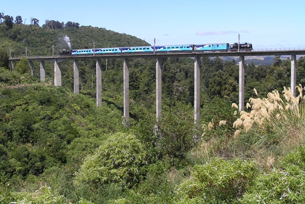
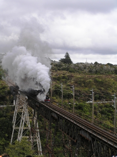
Aesthetic Significance or Value: This section of the NIMT features a varied and engaging natural landscape. Among the noteworthy dramatic natural features which the Historic Area passes through, over, or past are the scars created by the Rangitikei, Whanganui, and the numerous other rivers and streams which densely populate the area, many of which stem from Mount Ruapehu and the other mountains in the Tongariro National Park. A large section of the national park abuts the NIMT and this, as well as the scenic reserves along the railway that were established to preserve the pleasure travellers derived from the environment, achieve this initial intended goal. The variety of engineering techniques used to navigate this turbulent landscape form an agreeable contrast between the natural and the man-made, which makes the central section of the NIMT the most aesthetically disparate and pleasing portion of the NIMT for train travellers, and has subsequently been a key feature of the marketing of the NIMT journey throughout its history. Despite being designed primarily as utilitarian structures, several of the viaducts in the historic area have been identified as having significant aesthetic value, such as the NIMT construction era Makatote and Makohine Viaducts, which are among the most photographed railway structures in New Zealand, as well as more recent structures like the South Rangitikei Viaduct. Architectural Significance or Value: This NIMT Historic Area features the only two construction era railway stations which remain in use as stations in the central North Island and are fine examples of a nationally diminishing group of railway stations built to designs by George Troup, the Railways Department's first architect who had a major influence on station building design over a long period. These stations form an interesting contrast with the substantially larger late 20th century conception of a railway station at Taumarunui. When the construction and alterations in these three railway stations are viewed as a chronology they clearly delineate not only the changing functions of and requirements for railway stations in New Zealand over the 20th century, but also developments in building techniques, forms, and materials. Technological Significance or Value: The NIMT is an internationally recognised significant engineering accomplishment. Within this, the central North Island section of the NIMT posed the highest degree of technical difficulty and included eight viaducts, 15 tunnels and innumerable culverts, cuttings and embankments, stream diversions and other means of forging the railway during its construction in the early years of the 20th century. It was a colossal undertaking to finish this central and final section in the six years to 1908 after the completion of the Makohine Viaduct. The bridges, viaducts, tunnels, and earthworks which feature within this NIMT Historic Area demonstrate a range of representative types of engineered structures and sites built for railways in New Zealand from the beginning of the 20th century. The characteristic types within this Historic Area are supplemented by exceptional NIMT construction era places which have been recognised on individual merit by the NZHPT, and are complemented by their late 20th century counterparts such as the monumental viaducts and earthworks within the Mangaweka to Utiku and the Ohakune to Horopito Deviations. Among the oldest surviving of New Zealand's largest viaducts in this last completed part of the NIMT are the (old) Hapuawhenua, Makohine and Makatote Viaducts. Newer additions to the railway also rank among the most impressive nationally, with the South Rangitikei Viaduct being the second longest, and fourth highest in New Zealand, and its compatriots, the Kawhatau and North Rangitikei Viaducts, featuring the longest single bridge spans. The Raurimu Spiral has also received international recognition as a significant engineering feat. Aside from the aforementioned deviations and some smaller realignments, the NIMT in this section has largely remained true to the form of that first constructed and as such it is a testament to the skill and ingenuity of the early surveyors, engineers, contractors, and the labourers who worked to complete the most topographically complex and difficult portion of the entire NIMT. Prominent New Zealand engineers and surveyors directly associated with this section of the NIMT include Frederick William Furkert, Samuel John Harding, Peter Seton Hay, Robert West Holmes, John Davinci Louch, and John Rochfort. The subsequent major upgrade programmes in this NIMT Historic Area are representative of rail and engineering technological developments in New Zealand and are therefore of significant heritage value. In particular, the redundancy and replacement of several NIMT construction era structures such as the Whangaehu River Bridge after the Tangiwai Disaster, and that of the Piopiotea Stream Bridge and Manganui-o-te-ao Viaduct, as well as the viaducts on the Mangaweka to Utiku and Ohakune to Horopito Deviations, represent the continuance of some, and the development of other engineering principles and materials throughout the 20th century. The almost complete elimination of the once extensive series of tunnels from the functioning NIMT in this area also reflects a general move away from this type of structure within the New Zealand rail network dating from the electrification period.
Why is this place significant?
Cultural Significance
Social Significance or Value: This section of the NIMT has substantial social value as the main impetus behind settlement and the means of their ongoing economic viability within the central North Island for the greater part of the 20th century at least. In correspondence with the introduction of increased mechanisation in maintaining the railway, more efficient rail technologies, and also increased centralisation, the population and focus of a lot of the smaller towns along the NIMT in the central North Island changed, and many subsequently declined in population. Therefore, from the outset, this section of railway has had a significant impact on society in the area. In its heyday, the NIMT was an important social asset locally because it linked the scattered communities and facilitated social interaction and networks. It also achieved the same outcomes for these communities on a national and international level because it was the main postal route through the central North Island, and its stations acted as the portals for this and were often also the base of local telecommunications. The transport access created by the NIMT and also the concentration of communications technologies at its stations meant these buildings became socially important lifelines for the associated local community. Because it was the main means of travel through the central North Island and the direct link between the North Island's two largest cities for a large part of the 20th century, the NIMT has cemented itself in the consciousness of many New Zealanders. The route through the Central Plateau and King Country is prominent in this because of its impressive engineering feats and scenery. Because of the pervasive presence of the NIMT, and the importance of the railway as an employer and means of transport locally for a majority of the 20th century, there is a strong railway culture and sense of pride in rail heritage in the area, which is strengthened by that external to the area during railway related celebrations such as the NIMT Centenary events in 2008-2009.
Historic Significance
Historical Significance or Value The completion of the central section of the NIMT took 23 years and was only made possible because of the agreement of some Maori to allow surveying in, and then the establishment of the railway reserve through, the restricted area of the Rohe Potae. This access initiated one of the most expensive state projects undertaken in New Zealand and involved several key personalities including William Hall-Jones, Wahanui Hautare, Rewi Maniapoto, Richard Seddon, and Joseph Ward. The massive expenditure was justified by Julius Vogel and subsequent governments of the period, not simply because forging a direct route between Auckland and Wellington was a practical necessity, but also because it was a means of gaining a foothold in the King Country, of encouraging immigration to New Zealand, as well as a potential stimulus for settlement in the central North Island and the national economy. The NIMT was a major instrument of, and was central to, social and economic change within the central North Island and nationally. The railway through this once restricted area, in particular, can be seen as a symbol of the success of Vogel's policy, and as such has also been a significant factor in the realm of race relations. The delivery of this developmental potential was entirely dependant on the timely completion of the railway. As a result, the completion of the Makohine Viaduct and the subsequent closing of the gap between it and Taumarunui became a political imperative, as well as an economic one because the public were demanding a return on the immense investment. This final section was finished in a comparatively short time considering the scale of works required and the almost complete reliance on manual labour to do it. The national importance placed on the meeting of the railheads in late 1908 manifested with the NIMT's completions being heralded with significant fanfare. There have since been well attended and publicised celebrations to commemorate the 50th anniversary and centenary of this event. Because of the fact that the region had been largely closed off to Europeans and the associated formalised settlement prior to the building of the NIMT, any remaining NIMT construction era structures or sites are among, or are, the oldest remaining complete physical evidence of human incursion in the area. For its first 50 years the NIMT was the premier transport infrastructure asset in New Zealand. The railway through the central North Island allowed the establishment of settlements that in turn depended on the NIMT in order to prosper primarily through milling, agriculture, and horticulture. During this early period hundreds, sometimes thousands, of people per day travelled through or within this central North Island part of the railway either as part of the long journey from Auckland to Wellington, or between local towns, and it is therefore of considerable significance to the transport history of New Zealand. New Zealand's worst railway tragedy, the Tangiwai Disaster, also took place within the historic area. Since 1908, the ongoing significance of this section to New Zealand's rail network has been evidenced by the considerable resources which have been dedicated to its maintenance. Because of the density of relatively high maintenance structures within this Historic Area, this section has absorbed a large portion of these, but major upgrade programmes have also made sure that this section has continued viability. The fortunes of this state asset and the changes made as part of modernising the railways within New Zealand to keep them relevant and cost effective have directly affected this NIMT Historic Area. These have altered the form and fabric of the section, and its story can be seen as a microcosm for broader historical currents within New Zealand's rail history.
Physical Significance
Aesthetic Significance or Value: This section of the NIMT features a varied and engaging natural landscape. Among the noteworthy dramatic natural features which the Historic Area passes through, over, or past are the scars created by the Rangitikei, Whanganui, and the numerous other rivers and streams which densely populate the area, many of which stem from Mount Ruapehu and the other mountains in the Tongariro National Park. A large section of the national park abuts the NIMT and this, as well as the scenic reserves along the railway that were established to preserve the pleasure travellers derived from the environment, achieve this initial intended goal. The variety of engineering techniques used to navigate this turbulent landscape form an agreeable contrast between the natural and the man-made, which makes the central section of the NIMT the most aesthetically disparate and pleasing portion of the NIMT for train travellers, and has subsequently been a key feature of the marketing of the NIMT journey throughout its history. Despite being designed primarily as utilitarian structures, several of the viaducts in the historic area have been identified as having significant aesthetic value, such as the NIMT construction era Makatote and Makohine Viaducts, which are among the most photographed railway structures in New Zealand, as well as more recent structures like the South Rangitikei Viaduct. Architectural Significance or Value: This NIMT Historic Area features the only two construction era railway stations which remain in use as stations in the central North Island and are fine examples of a nationally diminishing group of railway stations built to designs by George Troup, the Railways Department's first architect who had a major influence on station building design over a long period. These stations form an interesting contrast with the substantially larger late 20th century conception of a railway station at Taumarunui. When the construction and alterations in these three railway stations are viewed as a chronology they clearly delineate not only the changing functions of and requirements for railway stations in New Zealand over the 20th century, but also developments in building techniques, forms, and materials. Technological Significance or Value: The NIMT is an internationally recognised significant engineering accomplishment. Within this, the central North Island section of the NIMT posed the highest degree of technical difficulty and included eight viaducts, 15 tunnels and innumerable culverts, cuttings and embankments, stream diversions and other means of forging the railway during its construction in the early years of the 20th century. It was a colossal undertaking to finish this central and final section in the six years to 1908 after the completion of the Makohine Viaduct. The bridges, viaducts, tunnels, and earthworks which feature within this NIMT Historic Area demonstrate a range of representative types of engineered structures and sites built for railways in New Zealand from the beginning of the 20th century. The characteristic types within this Historic Area are supplemented by exceptional NIMT construction era places which have been recognised on individual merit by the NZHPT, and are complemented by their late 20th century counterparts such as the monumental viaducts and earthworks within the Mangaweka to Utiku and the Ohakune to Horopito Deviations. Among the oldest surviving of New Zealand's largest viaducts in this last completed part of the NIMT are the (old) Hapuawhenua, Makohine and Makatote Viaducts. Newer additions to the railway also rank among the most impressive nationally, with the South Rangitikei Viaduct being the second longest, and fourth highest in New Zealand, and its compatriots, the Kawhatau and North Rangitikei Viaducts, featuring the longest single bridge spans. The Raurimu Spiral has also received international recognition as a significant engineering feat. Aside from the aforementioned deviations and some smaller realignments, the NIMT in this section has largely remained true to the form of that first constructed and as such it is a testament to the skill and ingenuity of the early surveyors, engineers, contractors, and the labourers who worked to complete the most topographically complex and difficult portion of the entire NIMT. Prominent New Zealand engineers and surveyors directly associated with this section of the NIMT include Frederick William Furkert, Samuel John Harding, Peter Seton Hay, Robert West Holmes, John Davinci Louch, and John Rochfort. The subsequent major upgrade programmes in this NIMT Historic Area are representative of rail and engineering technological developments in New Zealand and are therefore of significant heritage value. In particular, the redundancy and replacement of several NIMT construction era structures such as the Whangaehu River Bridge after the Tangiwai Disaster, and that of the Piopiotea Stream Bridge and Manganui-o-te-ao Viaduct, as well as the viaducts on the Mangaweka to Utiku and Ohakune to Horopito Deviations, represent the continuance of some, and the development of other engineering principles and materials throughout the 20th century. The almost complete elimination of the once extensive series of tunnels from the functioning NIMT in this area also reflects a general move away from this type of structure within the New Zealand rail network dating from the electrification period.
Construction Professional
Name
Anderson, John
Type
Architect
Biography
The information below is from the registration report for the North Island Main Trunk Line Historic Area (Revised 16 November 2009). J & A Anderson Ltd J & A Anderson Ltd was founded in 1850 by John Anderson Senior (1820-97) who was one of the earliest settlers in Christchurch and a prominent citizen having founded, or been a director, of large boards and companies in the region, and he was also an original member of the Christchurch Town Board, 1862. His sons, John (1850-1934) and Andrew (1851-1927), were sent back to John Senior's native Scotland for their education and engineering training. John Junior joined the company in 1873, and Andrew followed later in 1881 after working for the PWD and then the Christchurch Drainage Works. John Junior and Andrew were partners in the firm during the time that the company was responsible for the construction of the Waiteti, Makatote, Mangaturuturu, and Manganui-o-te-ao Viaducts on the NIMT.
Name
Furkert, Frederick William.
Type
Engineer
Biography
http://www.dnzb.govt.nz/dnzb/ - search for Furkert.
Name
Holmes, Robert West
Type
Engineer
Biography
PWD Engineer-in-Chief
Name
Troup, George Alexander
Type
Architect
Biography
G A Troup (1863-1941) was born in London in 1863 and educated in Scotland. He trained as an architect and engineer under C E Calvert of Edinburgh and came to New Zealand in 1884. After a short time with the Survey Department in Otago he became a draughtsman for New Zealand Railways in Dunedin and then, from 1888, in Wellington. Troup became Chief Draughtsman in 1894. He designed many station buildings throughout the county, some of which are still in use today; these buildings form an important part of New Zealand's landscape. His best known building is the Dunedin Railway Station (1904-07). He also designed the head office building in Wellington for Railways (1901, now demolished). Troup became a Fellow of the Royal Institute of British Architects in 1907. After World War I he was promoted to head the newly established Architectural Branch of New Zealand Railways. On retirement from Railways in 1925 he entered local body politics and was Mayor of Wellington from 1927 to 1931. Troup was prominent in the Presbyterian Church and founded the Presbyterian Young Men's Bible Class Union. He was an elder of the church for 47 years and also served on the governing bodies of several Wellington secondary schools. Education was a life-long interest and he was keenly involved in the training of engineering cadets in New Zealand Railways. Troup was knighted in 1937 and died in 1941. Last updated 1 October 2014 See also: James Veitch. 'Troup, George Alexander', Dictionary of New Zealand Biography, first published in 1993. Te Ara - the Encyclopedia of New Zealand, https://teara.govt.nz/en/biographies/2t49/troup-george-alexander
Name
Hay, Peter Seton
Type
Engineer
Biography
Peter Seton Hay (1852/1853? - 1907) was born in Glasgow, Scotland, probably in 1852 or 1853, the son of Janet (Jessie) Dalziel and her husband, James Johnston Hay, a journeyman engineer. When Peter was a child the family emigrated to New Zealand, arriving at Port Chalmers on the Storm Cloud in April 1860. Educated in Dunedin, he was the first graduate of the newly established University of Otago, obtaining a BA in 1877 and an MA with first-class honours in mathematics in 1878. In June 1875 on the advice of a university teacher he had joined the Public Works Department as an engineering cadet. After completing his studies he was engaged in railway surveys and construction for the lines from Dunedin to Moeraki and Clinton. In the early 1880s he was employed on Central Otago railway surveys from Rough Ridge to Hawea, in the Cromwell district, and from Balclutha to the Catlins River. Hay's reputation as a brilliant young engineer was established in these Otago days. Stories were told of his prodigious mental calculations when he was working in the field without the usual aids such as logarithm tables. In 1884 Hay was transferred to the head office of the Public Works Department in Wellington. He began his steady progress through the ranks of the department, and two years later was promoted to resident engineer. In 1896 he was promoted to superintending engineer, equivalent to assistant engineer-in-chief. By then the construction of the North Island main trunk rail link was the foremost Public Works Department project. Hay helped plan most of the important railway works of the central North Island section and was responsible for the primary design of the Makohine, Mangaweka, Hapuawhenua, Taonui, Manganui-a-te-ao and Makatote viaducts. By any standards the viaducts were great works of engineering. Much of the credit for their construction must be attributed to Peter Hay. Hay succeeded W. H. Hales as engineer-in-chief of the Public Works Department in 1906, only to die in office on 19 March 1907. He suffered the effects of exposure while inspecting the main trunk railway works near Waiouru, and subsequently died from pleurisy at his home in Wadestown, Wellington. He was aged 54. One of Hay's major achievements was his investigation and report on the proposed Southern Alps rail crossing by the Midland railway in 1903. The scheme recommended by the government's American advisory engineer, Virgil Gay Bogue, required a 3½-mile tunnel and a steep gradient incline track. Hay's scheme, which was ultimately adopted, avoided expensive grading and track work but required a tunnel over five miles long. This tunnel, at Otira, was completed in 1923, long after Hay's death. Equally important was Hay's contribution to the development of hydroelectric power generation in New Zealand. Peter Seton Hay married Mary Clarke at Wairuna, Otago, on 22 April 1879 and they had four sons and one daughter. His wife and children survived him. Hay was the first New Zealand-trained engineer to rise to the rank of engineer-in-chief. He died at the height of his powers and before many of his projects had been completed. Although his life was relatively brief, his works endured. Lowe, Peter. 'Hay, Peter Seton 1852/1853? - 1907'. Dictionary of New Zealand Biography, updated 16 December 2003 URL: http://www.dnzb.govt.nz/
Construction Details
Start Year
1885
Finish Year
1908
Type
Original Construction
Description
15 April 1885. The first sod of the NIMT's central section turned at Puniu River. November 1908 NIMT open to Erua
Start Year
1897
Type
Original Construction
Description
Makohine Viaduct started
Start Year
1900
Type
Original Construction
Description
Mangaweka Viaduct concrete work is completed
Finish Year
1902
Type
Original Construction
Description
June. Makohine Viaduct completed
Start Year
1902
Type
Other
Description
November. NIMT open to Mangaweka
Finish Year
1903
Type
Original Construction
Description
Mangaweka Viaduct completed
Start Year
1903
Type
Other
Description
Taumarunui is the northern railhead
Finish Year
1904
Type
Original Construction
Description
January. Matapuna Bridge completed. February. Toi Toi Viaduct completed
Start Year
1904
Type
Other
Description
NIMT open to Taihape
Start Year
1904
Type
Original Construction
Description
Mataroa Tunnel Started
Start Year
1905
Type
Original Construction
Description
Makatote Viaduct started. Raurimu Spiral started
Finish Year
1906
Type
Original Construction
Description
Mataroa Tunnel completed. Ngaurukehu Tunnel, Hautapu Bridge and Turangarere Horseshoe completed
Start Year
1906
Type
Other
Description
North railhead at Raurimu
Start Year
1906
Type
Original Construction
Description
Ohakune Railway Station constructed. Ohakune is southern railhead
Finish Year
1906
Type
Original Construction
Description
Ohakune to Horopito Coach Road completed
Finish Year
1907
Type
Original Construction
Description
Waimarino/National Park Railway Station completed
Start Year
1907
Type
Other
Description
June. NIMT open to Mataroa
Finish Year
1907
Type
Original Construction
Description
December. Taonui Viaduct completed
Finish Year
1908
Type
Original Construction
Description
Raurimu Spiral completed. April Hapuwhenua Viaduct completed. June Mangaturuturu Viaduct completed
Start Year
1908
Type
Other
Description
July. NIMT open to Waiouru
Finish Year
1908
Type
Original Construction
Description
10 July, Makatote Viaduct completed
Start Year
1908
Type
Other
Description
3 August, Temporary line constructed to enable passage of the 'Parliamentary Special'
Start Year
1908
Type
Other
Description
'Last Spike' commemorative obelisk constructed. 6 November' Last Spike' driven at Manganui-o-te-ao
Start Year
1925
Finish Year
1934
Type
Modification
Description
Upgrading and strengthening for NIMT bridges and installation of larger turntables in preparation for introduction of 'K' class locomotives
Start Year
1953
Type
Other
Description
24 December A lahar washes-out the Whangaehu River Bridge at Tangiwai
Finish Year
1957
Type
Original Construction
Description
Replacement Whangaehu River Bridge completed
Type
Other
Description
Programme of NIMT station closures and removals or demolition begins
Period
1960s
Finish Year
1962
Type
Original Construction
Description
Piopiotea Stream Bridge completed
Finish Year
1967
Type
Original Construction
Description
Manganui-o-te-ao Viaduct completed
Start Year
1973
Type
Other
Description
Mangaweka to Utiku deviation begun
Start Year
1973
Type
Original Construction
Description
South Rangitikei Viaduct started
Finish Year
1977
Type
Original Construction
Description
Blind Gully Embankment completed. Taumarunui Railway Station completed
Start Year
1979
Finish Year
1981
Type
Original Construction
Description
Kawhatau and North Rangitikei Viaducts
Finish Year
1981
Type
Original Construction
Description
August. South Rangitikei Viaduct completed
Start Year
1981
Type
Other
Description
18 November. Mangaweka to Utiku Deviation opened
Start Year
1982
Type
Demolished - Other
Description
Mangaweka Viaduct demolished
Start Year
1984
Type
Other
Description
Mataroa and Ngaurukehu Tunnels are prepared for electrification. Ohakune to Horopito Deviation started
Start Year
1987
Type
Original Construction
Description
(New) Hapuawhenua Viaduct completed. Ohakune to Horopito Deviation completed. NIMT electrification completed
Start Year
1989
Type
Other
Description
Tangiwai Memorial obelisk erected
Start Year
1994
Type
Other
Description
Tangiwai Historic Reserve established
Start Year
2006
Finish Year
2007
Type
Modification
Description
Makatote Viaduct underpinned
Start Year
2006
Finish Year
2009
Type
Modification
Description
Conservation of (old) Hapuawhenua Viaduct
This NIMT Historic Area features a section of the NIMT in the central North Island which was the pivotal area for the timely completion of that immense construction project, and covers approximately 200km of the rail corridor and ex-NIMT corridor. Within the area are several nationally recognised engineering feats and many representative examples, and as the sum of its parts this section of the NIMT is considered one of New Zealand's great engineering achievements. The NIMT's long beginning: The completion of the NIMT in late 1908 is described as '...one of the pivotal moments in New Zealand history' and '...arguably the New Zealand state's greatest achievement, at least in the first century after 1840, and certainly its greatest financial commitment.' The impetus for the NIMT was the need to create a direct link between New Zealand's two major cities, Auckland and Wellington. For 20 years prior to the NIMT's completion, goods and passenger traffic between these cities was typically directed from Auckland to New Plymouth via coastal shipping, then continued by ship or train onto Wellington and vice versa. The concept of the NIMT was mooted by Julius Vogel (1835-1899), then the Colonial Treasurer in William Fox's government, as part of his bold expansionist policy which was adopted by the House in 1870. With this plan Vogel intended that the railway would facilitate European access to the sealed-off King Country, or Rohe Potae, and enable the establishment of settlements which could support the railway and exploit the vast, and relatively untouched, resources of the Central Plateau region. From the mid-1860s Maori in the central North Island had repelled European encroachment by establishing, and staunchly upholding, the restricted area known as the Rohe Potae. After a decade of persistent approaches from the government regarding the area, talks between officials and some King Country chiefs regarding the establishment of the railway through their land began in earnest in 1883. A series of rigorous negotiations was then initiated with two Ngati Maniapoto leaders, Wahanui Huatare and Rewi Maniapoto. There seems to have been a feeling that the railway and European incursion into the King Country was inevitable, but these chiefs wanted to make sure that it was on their terms. In late 1884 Wahanui announced his intention to cooperate with the government over the railway, and he laid out a set of conditions before the House of Representatives on 1 November 1884. His requirements included the right of the King movement to manage their own affairs, the banning of liquor from Waikato-Ngati Maniapoto territory, the right of his people to have sole responsibility for administering their ancestral lands, and that they were compensated for the land which was used. Following this, in early 1885 surveyors were allowed into the Rohe Potae to locate possible railway routes. Because of the tenuous relationship between the Crown and King Country iwi it was felt that the negotiation process was essential. However, by only consulting with Wahanui and Maniapoto the government purposely side-stepped King Tawhiao and other leaders who opposed the railway. Therefore, this initial agreement was not universal and accordingly there were instances of resistance, such as the destruction of surveying marks. Despite some opposition, surveying and construction plans continued, and on 15 April 1885 it was Wahanui who wielded the shovel that turned the NIMT's first sod, which was then ceremonially wheeled away by Premier Robert Stout. Prior to the chiefs allowing surveyors into the Rohe Potae, possible railway corridors through the King Country were only speculative because there had not been any previous opportunity to map it in detail. There were several prospective routes for the NIMT and John Rochfort (1832-1893) surveyed for a proposed corridor through the Central Plateau between 1883 and 1887. This was said to be his tour de force because he had to start from scratch and cover a large and topographically complex area. Consequently, Rochfort spent a significant amount of time in [the] area and his tracks and huts were still used and featured on Public Works Department (PWD) plans decades later when his vision for the route was finally coming to fruition. However, it was only after much debate and delay that Rochfort's route for the NIMT was eventually followed. The Maori land which was required for Rochfort's route progressively passed into Crown ownership under the Public Works Acts of 1882 and 1894. This legislation stipulated that construction could not begin until the governor issued a proclamation detailing the middle-line that each successive section would take. However, right up until 1900 there was considerable political lobbying to have the route go through Taranaki, and this, as well as factors such as the economic depression of the 1890s, meant progress was greatly inhibited. A key reason for the NIMT project not stalling further was that there was loud public dissatisfaction over the prolonged construction period. This motivated parliament to inject significantly more resources to the project to facilitate a final flurry of activity which would see the last section between the Makohine Viaduct and Taumarunui completed. The drive to finish the NIMT: The construction of a railway was generally heralded in with the turning of the 'first sod' and book-ended with a ceremony involving the ‘driving of the last spike.' When the NIMT's first sod was turned at Puniu River, near Te Awamutu in 1885, it is probable that few would have imagined that the length of the time between ceremonies would have been as long as 23 years, despite the recognised monumentality of the task. By 1887 the first major construction contract was let, which was for the creation of the Poro-o-tarao Tunnel, and at the southern end the railhead was near Hunterville. Despite being completed in 1890, it was a further six years before railway traffic could use the line up to the tunnel. Slips were particularly troublesome at this northern end, and when combined with the infrequent delivery of construction materials, construction was held up for long periods. However, by 1901 bush clearing, the building of service roads, and formation work was underway in and around Taumarunui. At the same time at the southern end slow progress in building the Makohine Viaduct due to a series of unfortunate events including a flood and a workers strike in England, meant that the Makohine section which was begun in 1891 took a total of eleven years to finish. Throughout the entire length of the NIMT there were noteworthy structures and sites which drew on the ingenuity of the PWD engineers, contemporary engineering developments, and up-to-date techniques and materials. With the exception of features such as the Waiteti Viaduct and [Poro-o-tarao] Tunnel, the majority of the significant places are situated between the Makohine Viaduct and Taumarunui, as well as a wealth of representative types of NIMT construction era structures and sites. The completion of the Makohine Viaduct in 1902, after five years of construction, was a major hurdle and enabled the drive to complete the NIMT to progress from the south. From the north the railhead was approaching Taumarunui, and its arrival there in 1903 can be seen as a significant milestone and the deep breath before the plunge to tackle the ascent to the Central Plateau and the eventual connection of the railway. This last section of the NIMT demonstrates the variety of techniques available to the NIMT construction era engineers and is a marvel because this concentrated series of viaducts, bridges, tunnels, cuttings, embankments, culverts, stream diversions and other means of constructing the railway was managed in such a way that it only took six years to complete, whereas the construction of the central section took four times as long, and the entire NIMT took 35 years to build. A significant part of this rapid completion was the increase in resources after 1900 which enabled an injection of labourers dedicated to the project. For example, it is estimated that there were 400 to 500 people residing at and around the Makatote Viaduct work site, most of who worked on the viaduct and were immigrants from Britain or Australia in accordance with Vogel's plan. The size of this community was relatively large for the region at this time, even compared with established permanent settlements such as Ohakune which had a population of approximately 600 people in 1908. In general the advent of the NIMT boosted the European presence in the central North Island, but also affected the demographic spread of the region's pre-construction population. In particular, it has been noted that after 1900 the various Maori settlements around the Manganui-o-te-ao River were depopulated. This is because many gained employment as labourers on the NIMT and then gravitated towards the newly established European towns once their work was completed. The majority of the NIMT was built using the ‘co-operative system' which meant that the railway was divided into manageable chunks for groups of six to twelve men to complete. This system was a product of contemporary Liberal philosophy and also a result of the government being unhappy with the shoddy results from some public works which had been contracted out. The price paid for each section was determined by the supervising PWD engineer based on standard rates, and then a small percentage was added to this which was calculated in accordance with the profit margin a private contractor would have generally received. Therefore, labourers expected to earn more working as part of the ‘co-operative system' than for a private contractor. The men were paid their wages monthly based on the amount of their allocated section that they completed. However, the extent of this government control also drew criticism mainly because they determined the acceptable rate for the contract and many workers complained that this actually resulted in lower wages than they could earn working for a private firm like J & A Anderson Ltd, which was responsible for the construction of the significant ‘final push' structure, the Makatote Viaduct, and the steel superstructures of the Manganui-o-te-ao and Mangaturuturu Viaducts. A positive aspect of the system was that the PWD supplied the construction materials for the groups and also an overseer, which assured the government that materials and workmanship throughout the NIMT were of a consistent standard. However, whether they were privately contracted or part of the ‘cooperative system,' the men who worked on the central part of the NIMT did so in primitive living conditions and, in particular for those working on the ‘final push' between Ohakune and Raurimu, a harsh climate. On top of this, the nature of the work was physically strenuous and hazardous. The innumerable cuttings along the route were created primarily with picks and shovels and the tunnels carved out using picks and explosives, with lighting provided by candles and ‘well lights', which were kerosene based lamps. The inherent danger of this work is emphasised by the fact that one worker at the Mataroa Tunnel, Joseph Skerrett, is reported to have had one of his hands blown off because the dynamite caps he was holding exploded. It is therefore unsurprising that lives were also lost as a result of the construction project and working conditions. An example of this was the deaths of seven men during the construction of the Makatote Viaduct when they slipped and fell from its great height due to icy steelwork. The effects of the work could also be dangerous for those in the immediate area as was the case when a landslide was created by the tunnelling and construction work at the Makohine Viaduct and consequently killed several children and their mother. The construction project therefore not only had an immense monetary cost, but also took a physical toll. Aside from the mass of largely anonymous workers, there are certain people whose reputation as significant contributors to New Zealand engineering was cemented through their work on the NIMT. One such person was Peter Seton Hay. After becoming the first person to graduate from the University of Otago with a Bachelor of Arts in 1877, Hay joined the PWD and progressed through its ranks to become the engineer-in-chief by the time he died prematurely in 1907. Hay's designs for the Makohine, Mangaweka, Hapuawhenua, Taonui, Manganui-o-te-ao, Mangaturuturu, and Makatote Viaducts were all based on classic North American trestle viaducts. Aside from the Manganui-o-te-ao which was replaced in 1966, and the Mangaweka Viaduct which was demolished in 1982, these structures are surviving tributes to his vision and engineering prowess. Alongside his pioneering research into New Zealand's hydroelectric capabilities, these structures are considered to be his most important legacies. Another prominent engineer associated with the NIMT's ‘final push' was Frederick William Furkert (1876-1949). In 1906 the southern railhead had reached Ohakune and it became the base of operations for the works from that end with Furkert, in his role as Resident Engineer, also based there. Furkert was under considerable pressure to ensure that work progressed in keeping with the government's expectations, and the fact that the NIMT was finished on schedule in late 1908 has largely been attributed to his efficiency and management skills. The NIMT was not officially finished until the driving of the ‘Last Spike' at Manganui-o-te-ao by Premier Sir Joseph Ward on 6 November, 1908. However, prior to this event a temporary track was laid over the remaining incomplete section to enable the passage of the first through train from Wellington to Auckland between 6 and 8 August 1908; the so-called Ministerial, Parliamentary, or White Fleet ‘Special.' The rush to make the line passable for the ‘Special' meant that the ride through the unballasted section between Ohakune and Erua was a bumpy one for the dignitaries. These events, which were then followed by the first express train services in February 1909, heralded a new era in travel and the economy of New Zealand. Ups and downs: the NIMT post-construction: For the majority of the NIMT's first 50 years the railway was the main source of freight and passenger transportation in New Zealand. In this period when travel by car, if you had one, was tedious because of the state of the roads, and commercial air travel was in its infancy, the NIMT was not only used for long distance travel, but also became a way of life for the communities along its route. People used the trains to get to and from work, school, and social occasions. By the 1940s a popular service was the ‘picture trains' which transported patrons from the small towns into Taihape, Ohakune, and Taumarunui on weekend evenings to go late night shopping, or to the cinema, and dances. The travel experience through the central NIMT area was enhanced by the surrounding landscape and conservation areas such as the Tongariro National Park and the scenic reserves, and this became a central marketing tool for New Zealand Railways (NZR). The reserves were established at intervals along the length of the railway early in its history to preserve the scenery ‘for the benefit of future generations' in the midst of the milling and farming which beginning to take hold. The scenic reputation of the journey preceded it however a certain amount of imagination was required in this respect for those staring at out into the blackness on the popular night expresses. The 1920s to 1940s were the heyday of rail travel in New Zealand and this was reflected in the central part of the NIMT with the upgrading and expansion of passenger facilities at some if its stations. The presence of ‘refreshment rooms' at the three main stations in this section, Taihape, Ohakune and Taumarunui is particularly indicative of this. All of these refreshment rooms were open day and night in order to cater for passengers on the various services. At times when trains were stopped at these stations the platform would be awash with people welcoming disembarking passengers, or just there to ‘people watch.' However, the ‘refresh' was often the focus of the continuing passengers' attention at these times as they hurried to grab a snack before the train left for its next stage. This NZR service was well patronised during this period and the refreshment rooms were consistently busy. For example, between 1944 and 1948 it is estimated that each of the four trains which stopped at the Ohakune Railway Station every night contained 300 to 400 passengers, many of whom were hungry for the sandwiches and other goods made by the ‘refresh girls.' Railway stations were the ‘central community hub' of the towns along the NIMT. Not only a source of employment, the NIMT and its stations also provided an outlet for other industries in the district, and therefore milling towns, such as Rangataua and Kakahi, were heavily dependant on the railway and the associated stations and yards for their economic survival. Conversely, the contact created by the NIMT and its stations could be problematic, such as during the influenza pandemic which occurred late in 1918. Taumarunui was one of the worst affected by the virus. However, the death rates in the districts along the central section of the NIMT were also relatively high. In this way the presence of the railway was a mixed blessing. However, in general the railway was viewed as essential to the area. Stations in particular were important, not only as arrival and departure points, but because they often contained a Post Office, and sometimes the building housed a telephone exchange, as well the necessary rail operational communications equipment. Therefore, stations were often the communications centre of the towns, providing important links to the outside world for these relatively isolated communities, and as such were life-lines during emergencies. Larger scale examples of this was the role played by the Ohakune Railway Station and its staff during the Raetihi Fire of 1918, and later the station at Waiouru in the wake of the Tangiwai Disaster in 1953. It was estimated in the mid1960s that the opening of one road bridge per day was needed to keep up with demand because, just as the late 19th and early 20th century was the zenith of railway building in New Zealand, the mid 20th century saw a focus on expanding and enhancing road infrastructure assets. In the face of the greater competition from road transport and the resulting decline in passenger and then freight returns, by the mid to late 20th century NZR looked to streamline their operations, facilities, and resources on the NIMT and other railways within New Zealand. As a result, between the 1960s and 1980s non-essential services at stations were closed, such as the Refreshment Rooms in Ohakune Railway Station (1964), and Taumarunui (1975), and at Taihape in the late 1980s, and then the closure of many stations followed including Tangiwai, Hihitahi, Mataroa, Utiku, and Mangaweka in 1980, and Karioi and Manunui in 1982. Other NIMT construction era station buildings such as Waiouru, which was the highest railway station in New Zealand and had been particularly important for the transportation of military personnel, and Taihape were also removed or demolished. Likewise, low use or uneconomic lines throughout New Zealand were also closed during this period, including the Raetihi Branch Line in 1968. The outcome is that currently only the Ohakune, National Park, and Taumarunui Railway Stations remain which offer passenger facilities to NIMT travellers, and the majority of NIMT construction era station and flag station buildings have been removed. At the same time there was a national programme of modernisation and we see the introduction of systems such as Centralised Traffic Control (CTC) and the associated obsolesce of the old signalling system and its associated Signal Boxes. This was followed by other initiatives like the mechanisation of track gang work which greatly reduced staff numbers and centralised the employees to bigger stations such as Taumarunui. Technical advances and economics also influenced the replacement of many ailing railway structures with reinforced concrete, cost effective, equivalents, and within the NIMT this included the Piopiotea Stream Bridge and the Manganui-o-te-ao Viaduct. Perhaps the most noticeable change from the general public's view was the phasing out of steam locomotives from the 1950s, which was complete on the NIMT by the late 1960s. The not so obvious change which the replacement diesel locomotives allowed was that track could be systematically substituted with that of a marginally [narrower] gauge. The transformation of the NIMT into a modern railway was not lost on the public, and the upheavals drove a surge of railway nostalgia which can be seen by the ‘almost embarrassing number of steam-powered excursions' which coincided with the changes of the 1960s. While there had been changes in operations, and minor alterations as well as comprehensive up-grade programmes on the NIMT during its first 70 or so years, none were as fundamentally altering as the electrification of the line. [General upgrades to allow for heavier and faster trains had seen the policy of replacing ailing structures and eliminating or easing curves and steep grades implented since the 1960s, however the preparations for electrification saw these improvements gain impetus and urgency, because these features were undesirable in an electrified railway and impeded the smooth operation of its heavier and faster locomotives.] A result of this drive was the undertaking of perhaps the most significant railway construction project in New Zealand in the late 20th century; the creation of the Mangaweka to Utiku Deviation which was completed in 1981. Like the later Ohakune to Horopito Deviation, the Mangaweka to Utiku Deviation is one of the few sections of the NIMT that has diverted away from the NIMT construction era railway route to any great extent. This fact is a testament to the work and achievement of the early NIMT surveyors and engineers. Plans for the deviation were announced in the early 1960s. The NIMT construction era route around Mangaweka was famous for its sinuosity, its concentration of tunnels, and unsecure ground that was subject to the danger of washouts and slips. Rochfort had explored the possibility of taking the route down the eastern, rather than the eventual western, side of the Rangitikei River and then across that river and also the Kawhatau. However, it is probable that he was deterred by the number of costly and time consuming viaducts it required. Developments in engineering practices and materials by the late 20th century meant that this task, while still a considerable undertaking, was not unfeasible especially when weighed against the traffic speed advantages and reduced maintenance costs that a deviation promised. The early 1980s also saw NZR become a corporation and the commissioning of an influential report prepared in 1983 by consultants Booz, Allen, and Hamilton. This report suggested methods of making the railway profitable and the deviations in the central portion of the NIMT and electrification have aided in maintaining the feasibility of the railway as well as providing travellers with yet more engineering feats to marvel at.
This NIMT Historic Area features a section of the NIMT in the central North Island which was the pivotal area for the timely completion of that immense construction project, and covers approximately 200km of the rail corridor and ex-NIMT corridor. Within the area are several nationally recognised engineering feats and many representative examples, and as the sum of its parts this section of the NIMT is considered one of New Zealand's great engineering achievements. The NIMT's long beginning: The completion of the NIMT in late 1908 is described as '...one of the pivotal moments in New Zealand history' and '...arguably the New Zealand state's greatest achievement, at least in the first century after 1840, and certainly its greatest financial commitment.' The impetus for the NIMT was the need to create a direct link between New Zealand's two major cities, Auckland and Wellington. For 20 years prior to the NIMT's completion, goods and passenger traffic between these cities was typically directed from Auckland to New Plymouth via coastal shipping, then continued by ship or train onto Wellington and vice versa. The concept of the NIMT was mooted by Julius Vogel (1835-1899), then the Colonial Treasurer in William Fox's government, as part of his bold expansionist policy which was adopted by the House in 1870. With this plan Vogel intended that the railway would facilitate European access to the sealed-off King Country, or Rohe Potae, and enable the establishment of settlements which could support the railway and exploit the vast, and relatively untouched, resources of the Central Plateau region. From the mid-1860s Maori in the central North Island had repelled European encroachment by establishing, and staunchly upholding, the restricted area known as the Rohe Potae. After a decade of persistent approaches from the government regarding the area, talks between officials and some King Country chiefs regarding the establishment of the railway through their land began in earnest in 1883. A series of rigorous negotiations was then initiated with two Ngati Maniapoto leaders, Wahanui Huatare and Rewi Maniapoto. There seems to have been a feeling that the railway and European incursion into the King Country was inevitable, but these chiefs wanted to make sure that it was on their terms. In late 1884 Wahanui announced his intention to cooperate with the government over the railway, and he laid out a set of conditions before the House of Representatives on 1 November 1884. His requirements included the right of the King movement to manage their own affairs, the banning of liquor from Waikato-Ngati Maniapoto territory, the right of his people to have sole responsibility for administering their ancestral lands, and that they were compensated for the land which was used. Following this, in early 1885 surveyors were allowed into the Rohe Potae to locate possible railway routes. Because of the tenuous relationship between the Crown and King Country iwi it was felt that the negotiation process was essential. However, by only consulting with Wahanui and Maniapoto the government purposely side-stepped King Tawhiao and other leaders who opposed the railway. Therefore, this initial agreement was not universal and accordingly there were instances of resistance, such as the destruction of surveying marks. Despite some opposition, surveying and construction plans continued, and on 15 April 1885 it was Wahanui who wielded the shovel that turned the NIMT's first sod, which was then ceremonially wheeled away by Premier Robert Stout. Prior to the chiefs allowing surveyors into the Rohe Potae, possible railway corridors through the King Country were only speculative because there had not been any previous opportunity to map it in detail. There were several prospective routes for the NIMT and John Rochfort (1832-1893) surveyed for a proposed corridor through the Central Plateau between 1883 and 1887. This was said to be his tour de force because he had to start from scratch and cover a large and topographically complex area. Consequently, Rochfort spent a significant amount of time in [the] area and his tracks and huts were still used and featured on Public Works Department (PWD) plans decades later when his vision for the route was finally coming to fruition. However, it was only after much debate and delay that Rochfort's route for the NIMT was eventually followed. The Maori land which was required for Rochfort's route progressively passed into Crown ownership under the Public Works Acts of 1882 and 1894. This legislation stipulated that construction could not begin until the governor issued a proclamation detailing the middle-line that each successive section would take. However, right up until 1900 there was considerable political lobbying to have the route go through Taranaki, and this, as well as factors such as the economic depression of the 1890s, meant progress was greatly inhibited. A key reason for the NIMT project not stalling further was that there was loud public dissatisfaction over the prolonged construction period. This motivated parliament to inject significantly more resources to the project to facilitate a final flurry of activity which would see the last section between the Makohine Viaduct and Taumarunui completed. The drive to finish the NIMT: The construction of a railway was generally heralded in with the turning of the 'first sod' and book-ended with a ceremony involving the ‘driving of the last spike.' When the NIMT's first sod was turned at Puniu River, near Te Awamutu in 1885, it is probable that few would have imagined that the length of the time between ceremonies would have been as long as 23 years, despite the recognised monumentality of the task. By 1887 the first major construction contract was let, which was for the creation of the Poro-o-tarao Tunnel, and at the southern end the railhead was near Hunterville. Despite being completed in 1890, it was a further six years before railway traffic could use the line up to the tunnel. Slips were particularly troublesome at this northern end, and when combined with the infrequent delivery of construction materials, construction was held up for long periods. However, by 1901 bush clearing, the building of service roads, and formation work was underway in and around Taumarunui. At the same time at the southern end slow progress in building the Makohine Viaduct due to a series of unfortunate events including a flood and a workers strike in England, meant that the Makohine section which was begun in 1891 took a total of eleven years to finish. Throughout the entire length of the NIMT there were noteworthy structures and sites which drew on the ingenuity of the PWD engineers, contemporary engineering developments, and up-to-date techniques and materials. With the exception of features such as the Waiteti Viaduct and [Poro-o-tarao] Tunnel, the majority of the significant places are situated between the Makohine Viaduct and Taumarunui, as well as a wealth of representative types of NIMT construction era structures and sites. The completion of the Makohine Viaduct in 1902, after five years of construction, was a major hurdle and enabled the drive to complete the NIMT to progress from the south. From the north the railhead was approaching Taumarunui, and its arrival there in 1903 can be seen as a significant milestone and the deep breath before the plunge to tackle the ascent to the Central Plateau and the eventual connection of the railway. This last section of the NIMT demonstrates the variety of techniques available to the NIMT construction era engineers and is a marvel because this concentrated series of viaducts, bridges, tunnels, cuttings, embankments, culverts, stream diversions and other means of constructing the railway was managed in such a way that it only took six years to complete, whereas the construction of the central section took four times as long, and the entire NIMT took 35 years to build. A significant part of this rapid completion was the increase in resources after 1900 which enabled an injection of labourers dedicated to the project. For example, it is estimated that there were 400 to 500 people residing at and around the Makatote Viaduct work site, most of who worked on the viaduct and were immigrants from Britain or Australia in accordance with Vogel's plan. The size of this community was relatively large for the region at this time, even compared with established permanent settlements such as Ohakune which had a population of approximately 600 people in 1908. In general the advent of the NIMT boosted the European presence in the central North Island, but also affected the demographic spread of the region's pre-construction population. In particular, it has been noted that after 1900 the various Maori settlements around the Manganui-o-te-ao River were depopulated. This is because many gained employment as labourers on the NIMT and then gravitated towards the newly established European towns once their work was completed. The majority of the NIMT was built using the ‘co-operative system' which meant that the railway was divided into manageable chunks for groups of six to twelve men to complete. This system was a product of contemporary Liberal philosophy and also a result of the government being unhappy with the shoddy results from some public works which had been contracted out. The price paid for each section was determined by the supervising PWD engineer based on standard rates, and then a small percentage was added to this which was calculated in accordance with the profit margin a private contractor would have generally received. Therefore, labourers expected to earn more working as part of the ‘co-operative system' than for a private contractor. The men were paid their wages monthly based on the amount of their allocated section that they completed. However, the extent of this government control also drew criticism mainly because they determined the acceptable rate for the contract and many workers complained that this actually resulted in lower wages than they could earn working for a private firm like J & A Anderson Ltd, which was responsible for the construction of the significant ‘final push' structure, the Makatote Viaduct, and the steel superstructures of the Manganui-o-te-ao and Mangaturuturu Viaducts. A positive aspect of the system was that the PWD supplied the construction materials for the groups and also an overseer, which assured the government that materials and workmanship throughout the NIMT were of a consistent standard. However, whether they were privately contracted or part of the ‘cooperative system,' the men who worked on the central part of the NIMT did so in primitive living conditions and, in particular for those working on the ‘final push' between Ohakune and Raurimu, a harsh climate. On top of this, the nature of the work was physically strenuous and hazardous. The innumerable cuttings along the route were created primarily with picks and shovels and the tunnels carved out using picks and explosives, with lighting provided by candles and ‘well lights', which were kerosene based lamps. The inherent danger of this work is emphasised by the fact that one worker at the Mataroa Tunnel, Joseph Skerrett, is reported to have had one of his hands blown off because the dynamite caps he was holding exploded. It is therefore unsurprising that lives were also lost as a result of the construction project and working conditions. An example of this was the deaths of seven men during the construction of the Makatote Viaduct when they slipped and fell from its great height due to icy steelwork. The effects of the work could also be dangerous for those in the immediate area as was the case when a landslide was created by the tunnelling and construction work at the Makohine Viaduct and consequently killed several children and their mother. The construction project therefore not only had an immense monetary cost, but also took a physical toll. Aside from the mass of largely anonymous workers, there are certain people whose reputation as significant contributors to New Zealand engineering was cemented through their work on the NIMT. One such person was Peter Seton Hay. After becoming the first person to graduate from the University of Otago with a Bachelor of Arts in 1877, Hay joined the PWD and progressed through its ranks to become the engineer-in-chief by the time he died prematurely in 1907. Hay's designs for the Makohine, Mangaweka, Hapuawhenua, Taonui, Manganui-o-te-ao, Mangaturuturu, and Makatote Viaducts were all based on classic North American trestle viaducts. Aside from the Manganui-o-te-ao which was replaced in 1966, and the Mangaweka Viaduct which was demolished in 1982, these structures are surviving tributes to his vision and engineering prowess. Alongside his pioneering research into New Zealand's hydroelectric capabilities, these structures are considered to be his most important legacies. Another prominent engineer associated with the NIMT's ‘final push' was Frederick William Furkert (1876-1949). In 1906 the southern railhead had reached Ohakune and it became the base of operations for the works from that end with Furkert, in his role as Resident Engineer, also based there. Furkert was under considerable pressure to ensure that work progressed in keeping with the government's expectations, and the fact that the NIMT was finished on schedule in late 1908 has largely been attributed to his efficiency and management skills. The NIMT was not officially finished until the driving of the ‘Last Spike' at Manganui-o-te-ao by Premier Sir Joseph Ward on 6 November, 1908. However, prior to this event a temporary track was laid over the remaining incomplete section to enable the passage of the first through train from Wellington to Auckland between 6 and 8 August 1908; the so-called Ministerial, Parliamentary, or White Fleet ‘Special.' The rush to make the line passable for the ‘Special' meant that the ride through the unballasted section between Ohakune and Erua was a bumpy one for the dignitaries. These events, which were then followed by the first express train services in February 1909, heralded a new era in travel and the economy of New Zealand. Ups and downs: the NIMT post-construction: For the majority of the NIMT's first 50 years the railway was the main source of freight and passenger transportation in New Zealand. In this period when travel by car, if you had one, was tedious because of the state of the roads, and commercial air travel was in its infancy, the NIMT was not only used for long distance travel, but also became a way of life for the communities along its route. People used the trains to get to and from work, school, and social occasions. By the 1940s a popular service was the ‘picture trains' which transported patrons from the small towns into Taihape, Ohakune, and Taumarunui on weekend evenings to go late night shopping, or to the cinema, and dances. The travel experience through the central NIMT area was enhanced by the surrounding landscape and conservation areas such as the Tongariro National Park and the scenic reserves, and this became a central marketing tool for New Zealand Railways (NZR). The reserves were established at intervals along the length of the railway early in its history to preserve the scenery ‘for the benefit of future generations' in the midst of the milling and farming which beginning to take hold. The scenic reputation of the journey preceded it however a certain amount of imagination was required in this respect for those staring at out into the blackness on the popular night expresses. The 1920s to 1940s were the heyday of rail travel in New Zealand and this was reflected in the central part of the NIMT with the upgrading and expansion of passenger facilities at some if its stations. The presence of ‘refreshment rooms' at the three main stations in this section, Taihape, Ohakune and Taumarunui is particularly indicative of this. All of these refreshment rooms were open day and night in order to cater for passengers on the various services. At times when trains were stopped at these stations the platform would be awash with people welcoming disembarking passengers, or just there to ‘people watch.' However, the ‘refresh' was often the focus of the continuing passengers' attention at these times as they hurried to grab a snack before the train left for its next stage. This NZR service was well patronised during this period and the refreshment rooms were consistently busy. For example, between 1944 and 1948 it is estimated that each of the four trains which stopped at the Ohakune Railway Station every night contained 300 to 400 passengers, many of whom were hungry for the sandwiches and other goods made by the ‘refresh girls.' Railway stations were the ‘central community hub' of the towns along the NIMT. Not only a source of employment, the NIMT and its stations also provided an outlet for other industries in the district, and therefore milling towns, such as Rangataua and Kakahi, were heavily dependant on the railway and the associated stations and yards for their economic survival. Conversely, the contact created by the NIMT and its stations could be problematic, such as during the influenza pandemic which occurred late in 1918. Taumarunui was one of the worst affected by the virus. However, the death rates in the districts along the central section of the NIMT were also relatively high. In this way the presence of the railway was a mixed blessing. However, in general the railway was viewed as essential to the area. Stations in particular were important, not only as arrival and departure points, but because they often contained a Post Office, and sometimes the building housed a telephone exchange, as well the necessary rail operational communications equipment. Therefore, stations were often the communications centre of the towns, providing important links to the outside world for these relatively isolated communities, and as such were life-lines during emergencies. Larger scale examples of this was the role played by the Ohakune Railway Station and its staff during the Raetihi Fire of 1918, and later the station at Waiouru in the wake of the Tangiwai Disaster in 1953. It was estimated in the mid1960s that the opening of one road bridge per day was needed to keep up with demand because, just as the late 19th and early 20th century was the zenith of railway building in New Zealand, the mid 20th century saw a focus on expanding and enhancing road infrastructure assets. In the face of the greater competition from road transport and the resulting decline in passenger and then freight returns, by the mid to late 20th century NZR looked to streamline their operations, facilities, and resources on the NIMT and other railways within New Zealand. As a result, between the 1960s and 1980s non-essential services at stations were closed, such as the Refreshment Rooms in Ohakune Railway Station (1964), and Taumarunui (1975), and at Taihape in the late 1980s, and then the closure of many stations followed including Tangiwai, Hihitahi, Mataroa, Utiku, and Mangaweka in 1980, and Karioi and Manunui in 1982. Other NIMT construction era station buildings such as Waiouru, which was the highest railway station in New Zealand and had been particularly important for the transportation of military personnel, and Taihape were also removed or demolished. Likewise, low use or uneconomic lines throughout New Zealand were also closed during this period, including the Raetihi Branch Line in 1968. The outcome is that currently only the Ohakune, National Park, and Taumarunui Railway Stations remain which offer passenger facilities to NIMT travellers, and the majority of NIMT construction era station and flag station buildings have been removed. At the same time there was a national programme of modernisation and we see the introduction of systems such as Centralised Traffic Control (CTC) and the associated obsolesce of the old signalling system and its associated Signal Boxes. This was followed by other initiatives like the mechanisation of track gang work which greatly reduced staff numbers and centralised the employees to bigger stations such as Taumarunui. Technical advances and economics also influenced the replacement of many ailing railway structures with reinforced concrete, cost effective, equivalents, and within the NIMT this included the Piopiotea Stream Bridge and the Manganui-o-te-ao Viaduct. Perhaps the most noticeable change from the general public's view was the phasing out of steam locomotives from the 1950s, which was complete on the NIMT by the late 1960s. The not so obvious change which the replacement diesel locomotives allowed was that track could be systematically substituted with that of a marginally [narrower] gauge. The transformation of the NIMT into a modern railway was not lost on the public, and the upheavals drove a surge of railway nostalgia which can be seen by the ‘almost embarrassing number of steam-powered excursions' which coincided with the changes of the 1960s. While there had been changes in operations, and minor alterations as well as comprehensive up-grade programmes on the NIMT during its first 70 or so years, none were as fundamentally altering as the electrification of the line. [General upgrades to allow for heavier and faster trains had seen the policy of replacing ailing structures and eliminating or easing curves and steep grades implented since the 1960s, however the preparations for electrification saw these improvements gain impetus and urgency, because these features were undesirable in an electrified railway and impeded the smooth operation of its heavier and faster locomotives.] A result of this drive was the undertaking of perhaps the most significant railway construction project in New Zealand in the late 20th century; the creation of the Mangaweka to Utiku Deviation which was completed in 1981. Like the later Ohakune to Horopito Deviation, the Mangaweka to Utiku Deviation is one of the few sections of the NIMT that has diverted away from the NIMT construction era railway route to any great extent. This fact is a testament to the work and achievement of the early NIMT surveyors and engineers. Plans for the deviation were announced in the early 1960s. The NIMT construction era route around Mangaweka was famous for its sinuosity, its concentration of tunnels, and unsecure ground that was subject to the danger of washouts and slips. Rochfort had explored the possibility of taking the route down the eastern, rather than the eventual western, side of the Rangitikei River and then across that river and also the Kawhatau. However, it is probable that he was deterred by the number of costly and time consuming viaducts it required. Developments in engineering practices and materials by the late 20th century meant that this task, while still a considerable undertaking, was not unfeasible especially when weighed against the traffic speed advantages and reduced maintenance costs that a deviation promised. The early 1980s also saw NZR become a corporation and the commissioning of an influential report prepared in 1983 by consultants Booz, Allen, and Hamilton. This report suggested methods of making the railway profitable and the deviations in the central portion of the NIMT and electrification have aided in maintaining the feasibility of the railway as well as providing travellers with yet more engineering feats to marvel at.
CONSTRUCTION MATERIALS: Brick, concrete, corrugated iron, earth, glass, gravel, iron, steel, and timber CONSTRUCTION COMPANIES: Codelfa Construction Ltd Codelfa Construction Ltd was the Italian construction company who built the South Rangitikei Viaduct on the Mangaweka to Utiku Deviation. Ginn Brothers Ltd., Taumarunui Ginn Brothers Ltd. won the contract to construct the Taumarunui Railway Station in 1975. They completed the building in 1977. Scott Bros. Ltd, Christchurch This firm was owned by brothers John Lee (1844-1913) and George (1851-1930) Scott who both immigrated to New Zealand in 1870 from Derby, England, their hometown where they underwent their engineering training. They set up a large foundry and workshop in Christchurch in 1876 and the business manufactured farming machinery, locomotives, and other items such as the street lamps in central Christchurch. Aside from their work manufacturing steelwork for, or constructing, several prominent railway and combined bridges, the company's staple business was manufacturing Atlas ranges. Both brothers were prominent Christchurch citizens with John Lee sitting on the board of, and occasionally lecturing at, Canterbury College, and George being a member of the Christchurch City Council. Wilkins and Davies Construction Co. Ltd. Wilkins and Davies were the construction company responsible for building the Kawhatau and North Rangitikei Viaducts on the Mangaweka to Utiku Deviation. ENGINEERS: Beca Carter Hollings & Ferner Consulting Engineers Beca is an international employee-owned engineering and related consultancy services group, whose range of services includes engineering, planning, project management, architecture, GIS and surveying, cost estimating, asset management and valuations. Beca evolved from a company established in 1918. In the middle of the 20th century the company was then progressed by George Beca and Sir Ron Carter. Some of Beca's notable projects include the structural engineering for the design of the Auckland War Memorial Museum, the construction of gun emplacements during World War II, the grandstand at Ellerslie Racecourse, the Macau Tower, and many others. The company has national and international offices. Samuel John Harding (1861-1948) A New Zealand born and trained engineer, Harding was the Assistant Engineer in Hunterville from 1896, which coincided with the period when the Makohine Viaduct's construction was initiated. From 1903 he was stationed at Taihape and it is said that the 'section [of the NIMT] from Taihape to Waiouru was largely his creation.' After the completion of the NIMT Harding held several other PWD positions around New Zealand before his retirement in 1926. John Davinci Louch (1854-1937) Born and trained as a surveyor and engineer in Ireland, Louch immigrated to New Zealand in 1875. He initially worked as a PWD surveyor and then engineer in the northern North Island. In 1901 he was named Resident Engineer in charge of completing the NIMT from the northern end and held this position until the railway was completed in 1908. Late in that same year Louch was appointed the District Engineer of Wellington, a position he held until his retirement in 1920. Peter Keller (1880-1961) Keller was born on the West Coast of the South Island and is said to have been a protégé of Richard Seddon. Keller was an up-and-coming cadet, and then assistant engineer, involved in the construction of the NIMT between 1902 and 1908. He was mostly engaged around Taihape and then Raurimu, and as such worked on sites and structures including the Turangarere Horseshoe, the Raurimu Spiral, and the Makatote Viaduct. After the NIMT was finished he worked in Westland, Central North Island, and Taranaki. When he retired in 1943 Keller was the District Engineer at Dunedin. SURVEYORS: John Rochfort (See DNZB entry) PHYSICAL DESCRIPTION AND ANALYSIS: This NIMT Historic Area winds, climbs, and stretches over the narrow NIMT railway corridors of the central North Island, between a southern point of the Makohine Viaduct and the Taumarunui Railway Station to the north. The NIMT construction era line and subsequent deviations within this historic area encompass an approximately 200km long route. The form of the NIMT in the central section is largely defined by the topography in which it is situated. The vicissitudes in the landscape through which it passes over and through are evidence of the long history of the area's volcanic activity and violent upheavals, and the natural gouging progress of numerous waterways. From the south and north, the railway climbs towards its middle in the Central Plateau, and as it does it travels through farm, hill and tussock country, forests, over deep gorges, past some of New Zealand's most spectacular mountain scenery which allows views of Ruapehu, Ngauruhoe, Tongariro and sometimes Mount Taranaki in the distance, and beside and over several significant rivers; areas which are sparsely populated with the exception of the small towns which dot the NIMT and mark its progression for rail passengers. It is the diversity and drama of the landscape which makes the central part of the NIMT the aesthetic highlight of the long train journey from Wellington to Auckland and one of the most impressively scenic areas in New Zealand whether travelling by rail or road. Beginning from the Makohine Viaduct at the southern end of this NIMT Historic Area, the railway's ascent towards the Central Plateau begins to be more pronounced. The crossing of the Rangitikei valley by way of the 1981 deviation is relatively level and the deep crevasses of that river and others are navigated with a close succession of viaducts which culminate with the deviation rejoining the NIMT construction era route just south of the Toi Toi Viaduct near Utiku. To the west of the deviation the NIMT construction era route rose and fell sharply north of the Mangaweka Viaduct and through a series of tunnels. With this area's redundancy from the functioning NIMT it has been subsumed into the surrounding farmland [to some extent, although the fomation is still easily discernable and the tunnels survive]. From Taihape there is the long climb to Waiouru, beginning at a grade of 1 in 60 but largely at 1 in 70 from Mataroa to Hihitahi. The serpentine nature of the railway in this area is dictated by the Hautapu River which it either runs parallel to, or shadows throughout the Turangarere and Waiouru Sections. The grade also influenced the form of the corridor and necessitated the creation of the Turangarere Horseshoe to make it traversable. Waiouru Station was the highest railway station above sea level in New Zealand, which is indicative of the extent of the climb to get to it, as is the view which is dominated by the mountains. The railway from Waiouru to Ohakune is mostly characterised by a descent. Although following a predominantly straight course through Karioi and Rangataua, between Waiouru and Tangiwai is a sinuous section of track which has been noted as a speed trap and was the scene of the 1981 Silver Fern railcar derailment that killed four passengers. This section also features the Tangiwai Memorial Reserve on the banks of the Whangaehu River. North of Ohakune on the generally 1 in 60 gradient climb across the western flank of the Waimarino Plateau, the railway is punctuated by a close succession of viaducts and bridges crossing the numerous rivers and streams that flow down from and around the mountains, including the Manganui-o-te-ao River. Aside from the area between Ohakune and Horopito which cuts through the Tongariro National Park, the railway in this area is generally flanked by SH4 on one side, and the national park on the other. This area is the site of the Ohakune to Horopito Deviation as well as the line of the NIMT construction era route and the Ohakune to Horopito Coach Road which are also included in this NIMT Historic Area. Many of the features of the old corridor can be seen from the present functioning NIMT. Then, again with a few exceptions, the NIMT follows a straight north to north-eastern course until it reaches Raurimu and the famous Spiral. From National Park there is a long, steep descent off the Central Plateau with numerous curves down through Raurimu and Owhango to Kakahi, and an easier descent beyond this to Taumarunui. On the approach to Taumarunui at the northern end of this historic area, the NIMT follows the route of the Whanganui River closely before passing through Manunui and eventually across the river just south of Taumarunui Railway Station. This Historic Area features a selection of historic places which are linked by their NIMT use, ex-use, or closely related purpose and site. Key components of the historic area include specially engineered or architecturally designed railway structures and places along the NIMT construction era and current NIMT route such as bridges, buildings, significant earthworks, a road, tunnels, and viaducts. The continuity of view which the railway provided or currently affords, which incorporates the two adjacent commemorative reserves, is also an important feature. As well as the representative or exceptional structures and sites included as places within the historic area, there are innumerable subsidiary railway construction components and operational devices within its boundary such as culverts, cuttings, embankments, level crossings, underpasses, electrification and signalling paraphernalia, and the track itself and what it rests on, to name but a few. As this suggests, a railway is an intricate combination of many physical components which would be impractical to catalogue and assess in great detail for heritage values because many of these features, by their nature and for the smooth operation of the railway, are meant to be relatively temporary, or else they have been assessed as not being sufficiently significant contributing factors to the development and history of engineering and railways in New Zealand, or to the history of the NIMT, to warrant inclusion as places in the historic area. While not being dismissive of these components the places highlighted within this historic area are those which are generally considered representative of the developments in the engineering and railway history of New Zealand and contribute to this story, or those which are recognised as places of heritage value on their own merits. Railways, and the structures and sites within them, are typically built and operated based around the principle of continuous improvement and repair when needed. Therefore additions and alterations within this NIMT Historic Area are an integral part of its story and are representative of larger historical changes in railway operations and technology. The main periods of change include: bridge strengthening and other changes [during the late 1920s-1930s in preparation for the introduction of the K class locomotives], assessments of the economic viability of NIMT construction era bridges and subsequent upgrades or replacement, as well as the introduction of new operational technologies and centralisation which saw the closure or downsizing of stations from the 1960s, and finally, the electrification project during the 1980s. Over time, the general types and uses of fabrics within the NIMT did not change dramatically until the mid to late 20th century when the use of concrete took precedence. The use of concrete in the construction of the bridges and viaducts, a conscious policy in effect from the 1960s, was ultimately in aid of reduced maintenance costs and prolonging the functional life of the assets. The use of concrete is a key distinguishing factor between pre and post-1960s bridges and viaducts in this area. Concrete was used in NIMT construction era bridges and viaducts but was restricted to the footings, smaller piers, and abutments, with preference for steel trusses and plate girders in construction, with a few examples also featuring timber in their superstructure which has all needed to be substituted with more durable materials, or the entire structure replaced. Concrete was also used for lining the NIMT construction tunnels and culverts, and in recent times sleepers have been manufactured in concrete rather than the traditional timber. The youngest railway station in the area, the Taumarunui Railway Station, had concrete used in its construction, which is a departure from its timber built and clad NIMT construction era predecessors. The electrification project facilitated the most significant change in the form of the NIMT in the central North Island. Aside from the comprehensive installation of the electrification equipment and some alterations to tunnels, which included the lowering of floors and the creation of more services refuges, electrification also necessitated the only two major deviations away from the NIMT construction era route. In the case of the Mangaweka to Utiku Deviation, the repositioning of the rail corridor occurred because the Mangaweka Viaduct was no longer viable, and the collective of tunnels, reasonably heavy grades, and sinuous form of the track was unsuitable for an electrified railway. Although some heavy cutting and the immense embankment at Blind Gully were needed, as well as three major viaducts, the deviation route could achieve a relatively level and direct route in comparison. Likewise, the Ohakune to Horopito Deviation reduced the unnecessary tight curvatures of the existing route and the new Hapuawhenua Viaduct replaced the ailing NIMT construction era counterpart. Land included in the Registration: This NIMT Historic Area covers a long and narrow area defined by the past and present designated NIMT railway corridors within the thematic physical southern and northern boundaries of the Makohine Viaduct and Taumarunui Railway Station. The land in the area also includes recognised NIMT related places which are not part of the railway corridor, but are immediately adjacent to it, such as the land incorporated in the extents of the two commemorative sites and the Ohakune to Horopito Coach Road. It is important to acknowledge the vast range of places on or directly related to the NIMT between Wellington and Auckland which for thematic reasons are external to the land and sites included in this historic area. For instance, none of the 'railway towns' with their collections of railway worker cottages, or the many private sidings which branch from the NIMT, have been included in the area's extent despite the contribution they could make to a holistic history of the NIMT and its effects. Places of note external to the extent of the area or theme have been listed in a file note. Historic Places on Land included in the Registration: 1. Makohine Viaduct, Vol. II, Appendix 5.4.1, page 6 2. Mangaweka Viaduct footings, Vol. II, Appendix 5.4.2, page 9 3. Toi Toi Viaduct, Vol. II, Appendix 5.4.2, page 12 4. South Rangitikei Viaduct, Vol. II, Appendix 5.4.3, page 17 5. Blind Gully Embankment, Vol. II, Appendix 5.4.3, page 20 6. Kawhatau Viaduct, Vol. II, Appendix 5.4.3, page 23 7. North Rangitikei Viaduct, Vol. II, Appendix 5.4.3, page 26 8. Mataroa Tunnel, Vol. II, Appendix 5.4.4, page 30 9. Turangarere Horseshoe, Vol. II, Appendix 5.4.5, page 34 10. Whangaehu River Bridge, Vol. II, Appendix 5.4.7, page 41 11. Tangiwai Historic Reserve, Vol. II, Appendix 5.4.7, page 44 12. Ohakune Railway Station and Signal Box, Vol. II, Appendix 5.4.8, page 47 13. Ohakune to Horopito Old Coach Road, Vol. II, Appendix 5.4.9, page 48 14. (Old) Hapuawhenua Viaduct, Vol. II, Appendix 5.4.9, page 49 15. Taonui Viaduct, Vol. II, Appendix 5.4.9, page 51 16. (New) Hapuawhenua Viaduct, Vol. II, Appendix 5.4.9, page 54 17. Mangaturuturu Viaduct, Vol. II, Appendix 5.4.10, page 58 18. Manganui-o-te-ao Viaduct, Vol. II, Appendix 5.4.10, page 59 19. 'Last Spike' Memorial, Vol. II, Appendix 5.4.10, page 62 20. Makatote Viaduct, Vol. II, Appendix 5.4.10, page 63 21. National Park Railway Station, Vol. II, Appendix 5.4.11, page 66 22. Raurimu Spiral, Vol. II, Appendix 5.4.12, page 71 23. Piopiotea Stream Bridge, Vol. II, Appendix 5.4.12, page 72 24. Matapuna Bridge, Vol. II, Appendix 5.4.13, page 76 25. Taumarunui Railway Station, Vol. II, Appendix 5.4.13, page 77 Relationship between Historic Places: These places are NIMT construction era sites or are places subsequently constructed which are, or were, part of the functioning central section of the NIMT, or are NIMT related places immediately adjacent to the railway within the area bordered by the Makohine Viaduct and Taumarunui Railway Station. With the exception of the commemorative sites, the places in the historic area were all constructed to have the railway track running over, through, or directly adjacent to them and had their designs and construction sanctioned by the PWD or NZR. The completion of construction of all these places date from 1900. Key Elements of the Historic Area: A key element in this historic area is the linear, undulating, view shafts created by the rail corridors and their associated earthworks which also often open to afford comprehensive views of the surrounding landscape especially when crossing bridges. The adjacent scenic or historic reserves contribute to this too. Other important elements include the early 20th century tunnels, and concrete and steel bridges or viaducts, the mid to late 20th century concrete bridges and viaducts, and railway stations and associated buildings and yards.
CONSTRUCTION MATERIALS: Brick, concrete, corrugated iron, earth, glass, gravel, iron, steel, and timber CONSTRUCTION COMPANIES: Codelfa Construction Ltd Codelfa Construction Ltd was the Italian construction company who built the South Rangitikei Viaduct on the Mangaweka to Utiku Deviation. Ginn Brothers Ltd., Taumarunui Ginn Brothers Ltd. won the contract to construct the Taumarunui Railway Station in 1975. They completed the building in 1977. Scott Bros. Ltd, Christchurch This firm was owned by brothers John Lee (1844-1913) and George (1851-1930) Scott who both immigrated to New Zealand in 1870 from Derby, England, their hometown where they underwent their engineering training. They set up a large foundry and workshop in Christchurch in 1876 and the business manufactured farming machinery, locomotives, and other items such as the street lamps in central Christchurch. Aside from their work manufacturing steelwork for, or constructing, several prominent railway and combined bridges, the company's staple business was manufacturing Atlas ranges. Both brothers were prominent Christchurch citizens with John Lee sitting on the board of, and occasionally lecturing at, Canterbury College, and George being a member of the Christchurch City Council. Wilkins and Davies Construction Co. Ltd. Wilkins and Davies were the construction company responsible for building the Kawhatau and North Rangitikei Viaducts on the Mangaweka to Utiku Deviation. ENGINEERS: Beca Carter Hollings & Ferner Consulting Engineers Beca is an international employee-owned engineering and related consultancy services group, whose range of services includes engineering, planning, project management, architecture, GIS and surveying, cost estimating, asset management and valuations. Beca evolved from a company established in 1918. In the middle of the 20th century the company was then progressed by George Beca and Sir Ron Carter. Some of Beca's notable projects include the structural engineering for the design of the Auckland War Memorial Museum, the construction of gun emplacements during World War II, the grandstand at Ellerslie Racecourse, the Macau Tower, and many others. The company has national and international offices. Samuel John Harding (1861-1948) A New Zealand born and trained engineer, Harding was the Assistant Engineer in Hunterville from 1896, which coincided with the period when the Makohine Viaduct's construction was initiated. From 1903 he was stationed at Taihape and it is said that the 'section [of the NIMT] from Taihape to Waiouru was largely his creation.' After the completion of the NIMT Harding held several other PWD positions around New Zealand before his retirement in 1926. John Davinci Louch (1854-1937) Born and trained as a surveyor and engineer in Ireland, Louch immigrated to New Zealand in 1875. He initially worked as a PWD surveyor and then engineer in the northern North Island. In 1901 he was named Resident Engineer in charge of completing the NIMT from the northern end and held this position until the railway was completed in 1908. Late in that same year Louch was appointed the District Engineer of Wellington, a position he held until his retirement in 1920. Peter Keller (1880-1961) Keller was born on the West Coast of the South Island and is said to have been a protégé of Richard Seddon. Keller was an up-and-coming cadet, and then assistant engineer, involved in the construction of the NIMT between 1902 and 1908. He was mostly engaged around Taihape and then Raurimu, and as such worked on sites and structures including the Turangarere Horseshoe, the Raurimu Spiral, and the Makatote Viaduct. After the NIMT was finished he worked in Westland, Central North Island, and Taranaki. When he retired in 1943 Keller was the District Engineer at Dunedin. SURVEYORS: John Rochfort (See DNZB entry) PHYSICAL DESCRIPTION AND ANALYSIS: This NIMT Historic Area winds, climbs, and stretches over the narrow NIMT railway corridors of the central North Island, between a southern point of the Makohine Viaduct and the Taumarunui Railway Station to the north. The NIMT construction era line and subsequent deviations within this historic area encompass an approximately 200km long route. The form of the NIMT in the central section is largely defined by the topography in which it is situated. The vicissitudes in the landscape through which it passes over and through are evidence of the long history of the area's volcanic activity and violent upheavals, and the natural gouging progress of numerous waterways. From the south and north, the railway climbs towards its middle in the Central Plateau, and as it does it travels through farm, hill and tussock country, forests, over deep gorges, past some of New Zealand's most spectacular mountain scenery which allows views of Ruapehu, Ngauruhoe, Tongariro and sometimes Mount Taranaki in the distance, and beside and over several significant rivers; areas which are sparsely populated with the exception of the small towns which dot the NIMT and mark its progression for rail passengers. It is the diversity and drama of the landscape which makes the central part of the NIMT the aesthetic highlight of the long train journey from Wellington to Auckland and one of the most impressively scenic areas in New Zealand whether travelling by rail or road. Beginning from the Makohine Viaduct at the southern end of this NIMT Historic Area, the railway's ascent towards the Central Plateau begins to be more pronounced. The crossing of the Rangitikei valley by way of the 1981 deviation is relatively level and the deep crevasses of that river and others are navigated with a close succession of viaducts which culminate with the deviation rejoining the NIMT construction era route just south of the Toi Toi Viaduct near Utiku. To the west of the deviation the NIMT construction era route rose and fell sharply north of the Mangaweka Viaduct and through a series of tunnels. With this area's redundancy from the functioning NIMT it has been subsumed into the surrounding farmland [to some extent, although the fomation is still easily discernable and the tunnels survive]. From Taihape there is the long climb to Waiouru, beginning at a grade of 1 in 60 but largely at 1 in 70 from Mataroa to Hihitahi. The serpentine nature of the railway in this area is dictated by the Hautapu River which it either runs parallel to, or shadows throughout the Turangarere and Waiouru Sections. The grade also influenced the form of the corridor and necessitated the creation of the Turangarere Horseshoe to make it traversable. Waiouru Station was the highest railway station above sea level in New Zealand, which is indicative of the extent of the climb to get to it, as is the view which is dominated by the mountains. The railway from Waiouru to Ohakune is mostly characterised by a descent. Although following a predominantly straight course through Karioi and Rangataua, between Waiouru and Tangiwai is a sinuous section of track which has been noted as a speed trap and was the scene of the 1981 Silver Fern railcar derailment that killed four passengers. This section also features the Tangiwai Memorial Reserve on the banks of the Whangaehu River. North of Ohakune on the generally 1 in 60 gradient climb across the western flank of the Waimarino Plateau, the railway is punctuated by a close succession of viaducts and bridges crossing the numerous rivers and streams that flow down from and around the mountains, including the Manganui-o-te-ao River. Aside from the area between Ohakune and Horopito which cuts through the Tongariro National Park, the railway in this area is generally flanked by SH4 on one side, and the national park on the other. This area is the site of the Ohakune to Horopito Deviation as well as the line of the NIMT construction era route and the Ohakune to Horopito Coach Road which are also included in this NIMT Historic Area. Many of the features of the old corridor can be seen from the present functioning NIMT. Then, again with a few exceptions, the NIMT follows a straight north to north-eastern course until it reaches Raurimu and the famous Spiral. From National Park there is a long, steep descent off the Central Plateau with numerous curves down through Raurimu and Owhango to Kakahi, and an easier descent beyond this to Taumarunui. On the approach to Taumarunui at the northern end of this historic area, the NIMT follows the route of the Whanganui River closely before passing through Manunui and eventually across the river just south of Taumarunui Railway Station. This Historic Area features a selection of historic places which are linked by their NIMT use, ex-use, or closely related purpose and site. Key components of the historic area include specially engineered or architecturally designed railway structures and places along the NIMT construction era and current NIMT route such as bridges, buildings, significant earthworks, a road, tunnels, and viaducts. The continuity of view which the railway provided or currently affords, which incorporates the two adjacent commemorative reserves, is also an important feature. As well as the representative or exceptional structures and sites included as places within the historic area, there are innumerable subsidiary railway construction components and operational devices within its boundary such as culverts, cuttings, embankments, level crossings, underpasses, electrification and signalling paraphernalia, and the track itself and what it rests on, to name but a few. As this suggests, a railway is an intricate combination of many physical components which would be impractical to catalogue and assess in great detail for heritage values because many of these features, by their nature and for the smooth operation of the railway, are meant to be relatively temporary, or else they have been assessed as not being sufficiently significant contributing factors to the development and history of engineering and railways in New Zealand, or to the history of the NIMT, to warrant inclusion as places in the historic area. While not being dismissive of these components the places highlighted within this historic area are those which are generally considered representative of the developments in the engineering and railway history of New Zealand and contribute to this story, or those which are recognised as places of heritage value on their own merits. Railways, and the structures and sites within them, are typically built and operated based around the principle of continuous improvement and repair when needed. Therefore additions and alterations within this NIMT Historic Area are an integral part of its story and are representative of larger historical changes in railway operations and technology. The main periods of change include: bridge strengthening and other changes [during the late 1920s-1930s in preparation for the introduction of the K class locomotives], assessments of the economic viability of NIMT construction era bridges and subsequent upgrades or replacement, as well as the introduction of new operational technologies and centralisation which saw the closure or downsizing of stations from the 1960s, and finally, the electrification project during the 1980s. Over time, the general types and uses of fabrics within the NIMT did not change dramatically until the mid to late 20th century when the use of concrete took precedence. The use of concrete in the construction of the bridges and viaducts, a conscious policy in effect from the 1960s, was ultimately in aid of reduced maintenance costs and prolonging the functional life of the assets. The use of concrete is a key distinguishing factor between pre and post-1960s bridges and viaducts in this area. Concrete was used in NIMT construction era bridges and viaducts but was restricted to the footings, smaller piers, and abutments, with preference for steel trusses and plate girders in construction, with a few examples also featuring timber in their superstructure which has all needed to be substituted with more durable materials, or the entire structure replaced. Concrete was also used for lining the NIMT construction tunnels and culverts, and in recent times sleepers have been manufactured in concrete rather than the traditional timber. The youngest railway station in the area, the Taumarunui Railway Station, had concrete used in its construction, which is a departure from its timber built and clad NIMT construction era predecessors. The electrification project facilitated the most significant change in the form of the NIMT in the central North Island. Aside from the comprehensive installation of the electrification equipment and some alterations to tunnels, which included the lowering of floors and the creation of more services refuges, electrification also necessitated the only two major deviations away from the NIMT construction era route. In the case of the Mangaweka to Utiku Deviation, the repositioning of the rail corridor occurred because the Mangaweka Viaduct was no longer viable, and the collective of tunnels, reasonably heavy grades, and sinuous form of the track was unsuitable for an electrified railway. Although some heavy cutting and the immense embankment at Blind Gully were needed, as well as three major viaducts, the deviation route could achieve a relatively level and direct route in comparison. Likewise, the Ohakune to Horopito Deviation reduced the unnecessary tight curvatures of the existing route and the new Hapuawhenua Viaduct replaced the ailing NIMT construction era counterpart. Land included in the Registration: This NIMT Historic Area covers a long and narrow area defined by the past and present designated NIMT railway corridors within the thematic physical southern and northern boundaries of the Makohine Viaduct and Taumarunui Railway Station. The land in the area also includes recognised NIMT related places which are not part of the railway corridor, but are immediately adjacent to it, such as the land incorporated in the extents of the two commemorative sites and the Ohakune to Horopito Coach Road. It is important to acknowledge the vast range of places on or directly related to the NIMT between Wellington and Auckland which for thematic reasons are external to the land and sites included in this historic area. For instance, none of the 'railway towns' with their collections of railway worker cottages, or the many private sidings which branch from the NIMT, have been included in the area's extent despite the contribution they could make to a holistic history of the NIMT and its effects. Places of note external to the extent of the area or theme have been listed in a file note. Historic Places on Land included in the Registration: 1. Makohine Viaduct, Vol. II, Appendix 5.4.1, page 6 2. Mangaweka Viaduct footings, Vol. II, Appendix 5.4.2, page 9 3. Toi Toi Viaduct, Vol. II, Appendix 5.4.2, page 12 4. South Rangitikei Viaduct, Vol. II, Appendix 5.4.3, page 17 5. Blind Gully Embankment, Vol. II, Appendix 5.4.3, page 20 6. Kawhatau Viaduct, Vol. II, Appendix 5.4.3, page 23 7. North Rangitikei Viaduct, Vol. II, Appendix 5.4.3, page 26 8. Mataroa Tunnel, Vol. II, Appendix 5.4.4, page 30 9. Turangarere Horseshoe, Vol. II, Appendix 5.4.5, page 34 10. Whangaehu River Bridge, Vol. II, Appendix 5.4.7, page 41 11. Tangiwai Historic Reserve, Vol. II, Appendix 5.4.7, page 44 12. Ohakune Railway Station and Signal Box, Vol. II, Appendix 5.4.8, page 47 13. Ohakune to Horopito Old Coach Road, Vol. II, Appendix 5.4.9, page 48 14. (Old) Hapuawhenua Viaduct, Vol. II, Appendix 5.4.9, page 49 15. Taonui Viaduct, Vol. II, Appendix 5.4.9, page 51 16. (New) Hapuawhenua Viaduct, Vol. II, Appendix 5.4.9, page 54 17. Mangaturuturu Viaduct, Vol. II, Appendix 5.4.10, page 58 18. Manganui-o-te-ao Viaduct, Vol. II, Appendix 5.4.10, page 59 19. 'Last Spike' Memorial, Vol. II, Appendix 5.4.10, page 62 20. Makatote Viaduct, Vol. II, Appendix 5.4.10, page 63 21. National Park Railway Station, Vol. II, Appendix 5.4.11, page 66 22. Raurimu Spiral, Vol. II, Appendix 5.4.12, page 71 23. Piopiotea Stream Bridge, Vol. II, Appendix 5.4.12, page 72 24. Matapuna Bridge, Vol. II, Appendix 5.4.13, page 76 25. Taumarunui Railway Station, Vol. II, Appendix 5.4.13, page 77 Relationship between Historic Places: These places are NIMT construction era sites or are places subsequently constructed which are, or were, part of the functioning central section of the NIMT, or are NIMT related places immediately adjacent to the railway within the area bordered by the Makohine Viaduct and Taumarunui Railway Station. With the exception of the commemorative sites, the places in the historic area were all constructed to have the railway track running over, through, or directly adjacent to them and had their designs and construction sanctioned by the PWD or NZR. The completion of construction of all these places date from 1900. Key Elements of the Historic Area: A key element in this historic area is the linear, undulating, view shafts created by the rail corridors and their associated earthworks which also often open to afford comprehensive views of the surrounding landscape especially when crossing bridges. The adjacent scenic or historic reserves contribute to this too. Other important elements include the early 20th century tunnels, and concrete and steel bridges or viaducts, the mid to late 20th century concrete bridges and viaducts, and railway stations and associated buildings and yards.
Historical and Associated Iwi / Hapū / Whānau
Completion Date
16th November 2009
Report Written By
Karen Astwood
Information Sources
Appendices to the Journals of the House of Representatives (AJHR)
Appendices to the Journals of the House of Representatives
Bromby, 2003
Robin Bromby. Rails that Built a Nation. An Encyclopedia of New Zealand Railways. Grantham House. 2003
Dictionary of New Zealand Biography
Dictionary of New Zealand Biography
Furkert, 1953
Frederick William Furkert, Early New Zealand Engineers, Wellington, 1953
Smith, 2001
Nigel Smith, Heritage of Industry: Discovering New Zealand's Industrial History, Auckland, 2001
Thornton, 2001
Geoffrey Thornton, Bridging the Gap, Early Bridges in New Zealand 1830-1939, Auckland, 2001
Waitangi Tribunal
Waitangi Tribunal Report, www.waitangi-tribunal.govt.nz
Wright, 1999
M Wright, New Zealand's Engineering Heritage: 1870 - 2000, Auckland, 1999
Pierre, 1981
Pierre, W. 1981. North Island Main Trunk: An Illustrated History, Christchurch
Atkinson, 2007
N Atkinson, Trainland: How railways made New Zealand, Auckland, 2007
Booz, 1983
Booz, Allen, and Hamilton, Comprehensive Review of Operations and Strategic Options Evaluation, Wellington, 1983
New Zealand Railway Observer
New Zealand Railway Observer
Roberts, 1990 (2)
F K Roberts, A Compendium of Railway Construction: Part Two, North Island Main Trunk, Wellington, 1990
Other Information
This historic area encompasses structures and sites along the functioning NIMT which can therefore be accessed via passenger train travel. However, significant portions of this section of the NIMT, and some now disused sections, run parallel to State Highway (SH)1, SH4, and SH49 through the central North Island and many of the places in the historic area can be viewed or accessed from the roadside. A fully referenced Registration Report is available from the NZHPT Central region office. The information provided is from the Registration Report. Information added after registration is shown in square brackets. Please note that entry on the New Zealand Heritage List/Rarangi Korero identifies only the heritage values of the property concerned, and should not be construed as advice on the state of the property, or as a comment of its soundness or safety, including in regard to earthquake risk, safety in the event of fire, or insanitary conditions.
Current Usages
Uses: Agriculture
Specific Usage: Farm
Uses: Civic Facilities
Specific Usage: Historic Property
Uses: Commemoration
Specific Usage: Disaster Site
Uses: Commemoration
Specific Usage: Monuments, memorial, site of particular event - other
Uses: Trade
Specific Usage: Cafe
Uses: Transport
Specific Usage: Bridge/ Viaduct
Uses: Transport
Specific Usage: Footpath/Path/track
Uses: Transport
Specific Usage: Railway
Uses: Transport
Specific Usage: Railway station/ platform/ refreshment room
Uses: Transport
Specific Usage: Tunnel
Former Usages
General Usage: Commemoration
Specific Usage: Disaster Site
General Usage: Commemoration
Specific Usage: Monuments, memorial, site of particular event - other
General Usage: Transport
Specific Usage: Bridge/ Viaduct
General Usage: Transport
Specific Usage: Railway
General Usage: Transport
Specific Usage: Railway station/ platform/ refreshment room
General Usage: Transport
Specific Usage: Tunnel
Themes
North Island Main Trunk Line
Of Significance to Maori
Web Links
description: Engineering NZ Heritage - Electrification
description: Engineering NZ Heritage - Main Trunk Railway
url: https://www.engineeringnz.org/our-work/heritage/heritage-records/north-island-main-trunk-railway/
description: Engineering NZ Heritage - Raurimu Spiral
url: https://www.engineeringnz.org/our-work/heritage/heritage-register/raurimu-spiral/
description: Engineering NZ Heritage - Mangaweka to Ukitu Rail Deviation
description: Engineering NZ Heritage - Ohakune to Horopito Old Coach Road
url: https://www.engineeringnz.org/our-work/heritage/heritage-records/ohakune-horopito-old-coach-road/
Location
Related listings
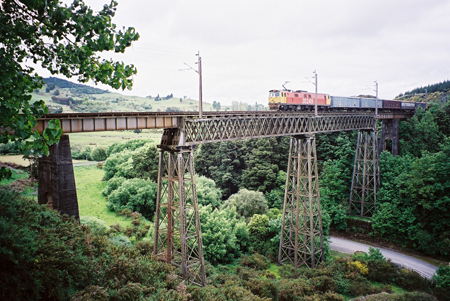
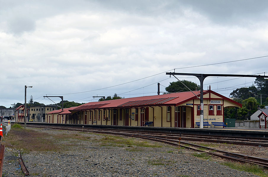
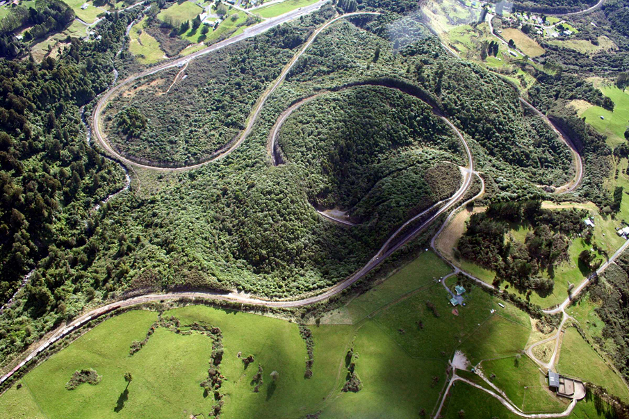
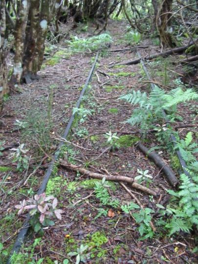
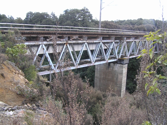
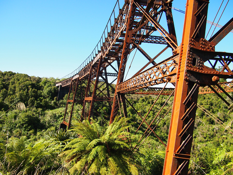
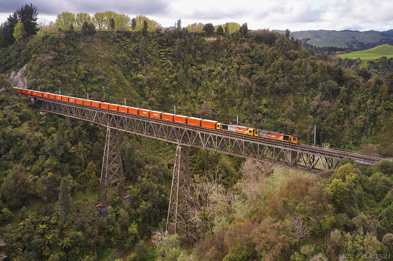
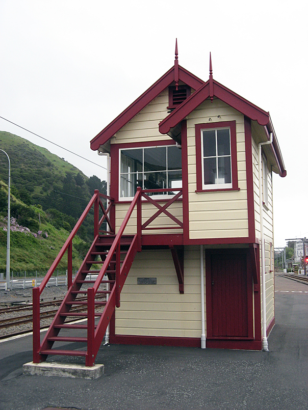
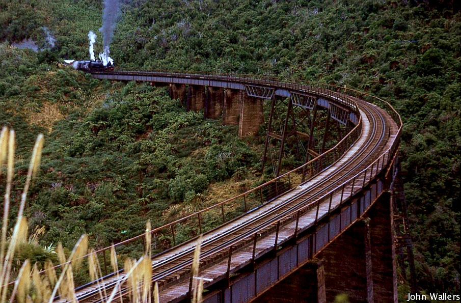
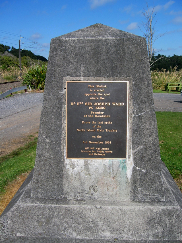
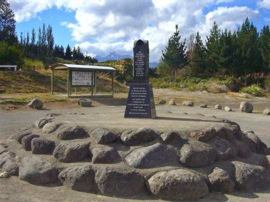
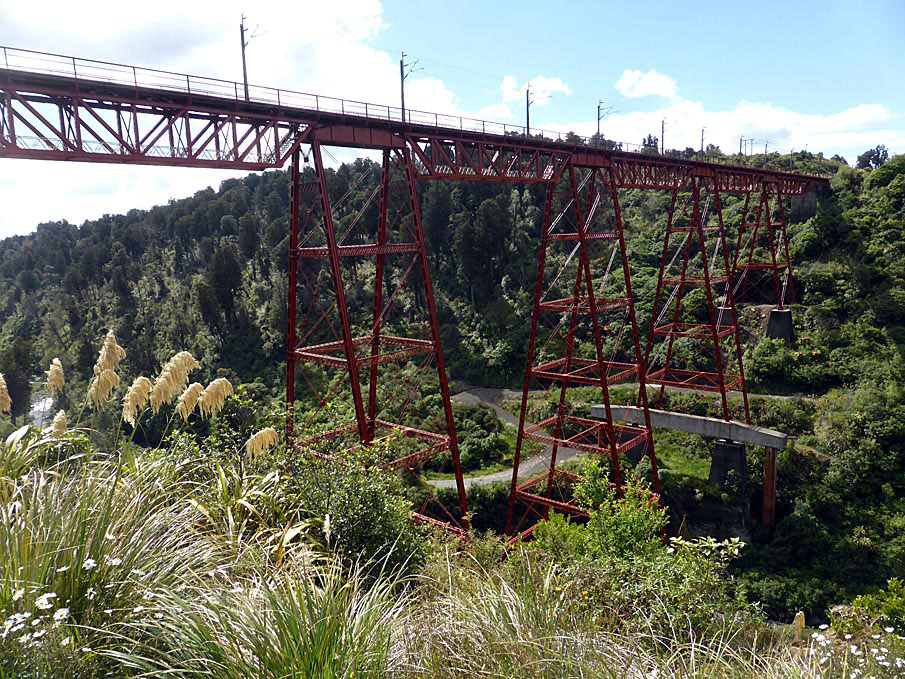
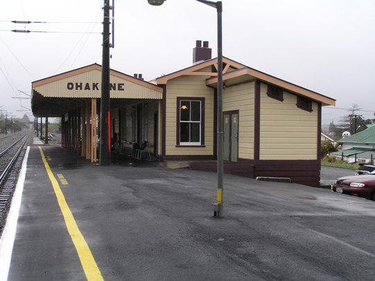
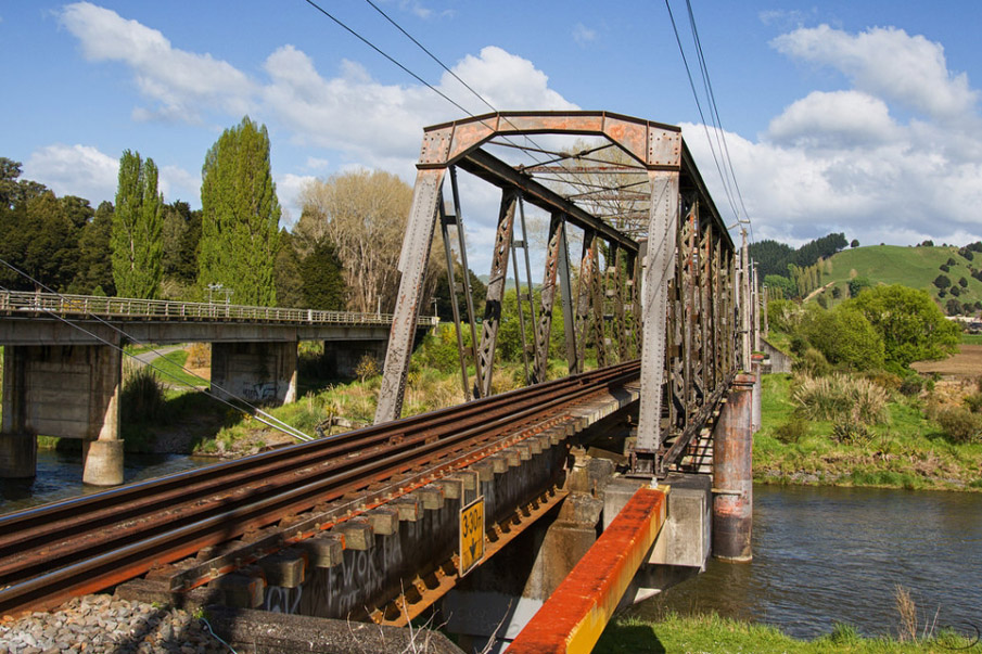
Sign up to hear more
Get the latest heritage news, features and events delivered
straight to your inbox.
