

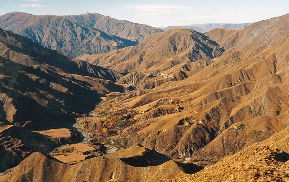
The Macetown Historic Area is set in a dramatic and isolated area around the Arrow River and the surrounding mountains. The small settlement of Macetown was the base of the alluvial and hard rock miners from the 1860s through until the 1930s. The Macetown Historic Area provides rich insight into the lives and work of miners and their families in this remote and spectacular location. In addition to its aesthetic value, the Macetown Historic Area is archaeologically rich, historically and technologically important as a reflection of changing gold mining technologies in the nineteenth to twentieth centuries, and of social significance. Gold was discovered in the Arrow River in 1862 and by Christmas 1862 more than 1,500 miners were camped along the river from its junction with the Kawarau River to Twelve Mile Creek. A canvas town developed at the junction of Twelve Mile creek (also known as the Rich Burn) and the Arrow River, this became the nucleus of Macetown which had a population of some 300 residents in January of 1863. As the alluvial gold was extracted and miners moved to the West Coast gold fields in 1865, the population of Macetown declined until the discovery of quartz reefs in the 1870s. Many companies were formed to work these reefs although only a few were successful. The mines provided steady employment for the town with the population peaking in 1896. After 1896 the Macetown’s population fell, particularly with the closure of the Premier Mine (1905) and the Homeward Bound Battery (1914). There was renewed interest in the area after the First World War and during the 1930s Depression. After this, only one resident – William Jenkins – remained. The Macetown Historic Area includes the present Macetown Historic Reserve, which protects some of the most important features of the area, namely the township site, Anderson’s Battery and the Homeward Bound Battery, but extends to include the significant gold mining history outside the reserve boundary, representing the important archaeological landscape. There are numerous remains of mining operations, including battery sites, hut sites, tramway formations, aerial cableway remains, adits, shafts, mullock heaps and items of mining plant. Included in the historic area is the site of New Zealand’s highest goldmine, the Sunrise, at nearly a mile high. In recent years the Macetown area has been a tourist attraction and part of the significant recreation areas around Arrowtown and Queenstown, visited by independent travellers and guided tours.

Location
List Entry Information
Overview
Detailed List Entry
Status
Listed
List Entry Status
Historic Area
Access
Able to Visit
List Number
9055
Date Entered
6th June 2018
Date of Effect
7th July 2018
City/District Council
Queenstown-Lakes District
Region
Otago Region
Extent of List Entry
This historic area consists of an area of land that contains a group of inter-related historic places. The identified historic places that contribute to the values in this historic area are included in the key to the maps in Appendix 1 of the List entry report. The area of land that encompasses these historic places, includes part of the land described as Pt RUN 27 (RTs 5677, OT15C/615, OTA2/1228), Crown Land Blk XVIII Shotover Survey District (Sec 58 Land Act 1948), Crown Land Blk XIV Shotover Survey District (Sec 58 Land Act 1948), Crown Land Soho Survey District (Sec 58 Land Act 1948), RUN 23 (RT OT15B/734), Legal Road, Legal River (NZ Gazette 1983 p 2010), Otago Land District, and the land described as Crown Land Soho Survey District (Sec 58 Land Act 1948), Crown Land Blk XVIII Shotover Survey District (Sec 58 Land Act 1948), Crown Land Blk XIV Shotover Survey District (Sec 58 Land Act 1948), Sec 2 Blk XIV Shotover SD (Conservation Act 1987 SO 22288 F41/2), Secs 1-6 Blk I Town of Macetown (NZ Gazette 1980 p 912), Sec 4 Blk II Town of Macetown (NZ Gazette 1980 p 912), Secs 2, 4-5, 8 Blk III Town of Macetown (NZ Gazette 1980 p 912), Secs 1-6 Blk IV Town of Macetown (NZ Gazette 1980 p 912), Secs 1-3, 8-9, 11-12 Blk V Town of Macetown (NZ Gazette 1980 p 912), Secs 1-6 Blk VI Town of Macetown (NZ Gazette 1980 p 912), Secs 2, 5 Blk VII Town of Macetown (NZ Gazette 1980 p 912), Secs 1-15 Blk VIII Town of Macetown (NZ Gazette 1980 p 912), Secs 1-4 Blk IX Town of Macetown (NZ Gazette 1980 p 912), Secs 1-10 Blk X Town of Macetown (NZ Gazette 1980 p 912), Secs 1-10 Blk XI Town of Macetown (NZ Gazette 1980 p 912), Secs 1-9 Blk XII Town of Macetown (NZ Gazette 1980 p 912), Secs 1-9 Blk XIII Town of Macetown (NZ Gazette 1980 p 912), Crown Land Town of Macetown (NZ Gazette 1980 p 912), RUN 23 (RT OT15B/734), Pt RUN 27 (RTs 5677, OT15C/615, OTA2/1228), Part RUN 27 (NZ Gazette 1980 p 912), Secs 1-3 Blk II Town of Macetown (RT OT15C/615, OTA2/1228, NZ Gazette 1980 p 912), Sec 1 Blk III Town of Macetown (RT OT15C/615, OTA2/1228, NZ Gazette 1980 p 912), Secs 6-7, 9-10 Blk III Town of Macetown (RT OT15C/615, OTA2/1228, NZ Gazette 1980 p 912), Secs 4-7, 10, 13-14 Blk V Town of Macetown (RT OT15C/615, OTA2/1228, NZ Gazette 1980 p 912), Secs 1, 3-4, 6-7 Blk VII Town of Macetown (RT OT180/199), Sec 3 Blk III Town of Macetown (RT OT72/273, NZ Gazette 1980 p 912), Sec 1 Blk XIV Shotover SD (NZ Gazette 1980 p 912), Sec 7 Blk I Town of Macetown, Mining Reserve Blk II Town of Macetown, Secs 5-8 Blk II Town of Macetown, Secs 11-12 Blk III Town of Macetown, Mining Reserve Blk IV Town of Macetown, Secs 7-8 Blk IV Town of Macetown, Secs 15-18 Blk V Town of Macetown, Sec 7 Blk VI Town of Macetown, Sec 16 Blk VIII Town of Macetown, Sec 5 Blk IX Town of Macetown, Secs 11-13 Blk X Town of Macetown, Mining Reserve Blk X Town of Macetown, Sec 11 Blk XI Town of Macetown, Mining Reserve Blk XII Town of Macetown, Secs 10-12 Blk XII Town of Macetown, Sec 10 Blk XIII Town of Macetown, Otago Land District. (Refer to map in Appendix 1 of the List entry report for further information).
Legal description
Crown Land Soho Survey District (Sec 58 Land Act 1948), Crown Land Blk XVIII Shotover Survey District (Sec 58 Land Act 1948), Crown Land Blk XIV Shotover Survey District (Sec 58 Land Act 1948), Sec 2 Blk XIV Shotover SD (Conservation Act 1987 SO 22288 F41/2), Secs 1-6 Blk I Town of Macetown (NZ Gazette 1980 p 912), Sec 4 Blk II Town of Macetown (NZ Gazette 1980 p 912), Secs 2, 4-5, 8 Blk III Town of Macetown (NZ Gazette 1980 p 912), Secs 1-6 Blk IV Town of Macetown (NZ Gazette 1980 p 912), Secs 1-3, 8-9, 11-12 Blk V Town of Macetown (NZ Gazette 1980 p 912), Secs 1-6 Blk VI Town of Macetown (NZ Gazette 1980 p 912), Secs 2, 5 Blk VII Town of Macetown (NZ Gazette 1980 p 912), Secs 1-15 Blk VIII Town of Macetown (NZ Gazette 1980 p 912), Secs 1-4 Blk IX Town of Macetown (NZ Gazette 1980 p 912), Secs 1-10 Blk X Town of Macetown (NZ Gazette 1980 p 912), Secs 1-10 Blk XI Town of Macetown (NZ Gazette 1980 p 912), Secs 1-9 Blk XII Town of Macetown (NZ Gazette 1980 p 912), Secs 1-9 Blk XIII Town of Macetown (NZ Gazette 1980 p 912), Crown Land Town of Macetown (NZ Gazette 1980 p 912), RUN 23 (RT OT15B/734), Pt RUN 27 (RTs 5677, OT15C/615, OTA2/1228), Part RUN 27 (NZ Gazette 1980 p 912), Secs 1-3 Blk II Town of Macetown (RT OT15C/615, OTA2/1228, NZ Gazette 1980 p 912), Sec 1 Blk III Town of Macetown (RT OT15C/615, OTA2/1228, NZ Gazette 1980 p 912), Secs 6-7, 9-10 Blk III Town of Macetown (RT OT15C/615, OTA2/1228, NZ Gazette 1980 p 912), Secs 4-7, 10, 13-14 Blk V Town of Macetown (RT OT15C/615, OTA2/1228, NZ Gazette 1980 p 912), Secs 1, 3-4, 6-7 Blk VII Town of Macetown (RT OT180/199), Sec 3 Blk III Town of Macetown (RT OT72/273, NZ Gazette 1980 p 912), Sec 1 Blk XIV Shotover SD (NZ Gazette 1980 p 912), Sec 7 Blk I Town of Macetown, Mining Reserve Blk II Town of Macetown, Secs 5-8 Blk II Town of Macetown, Secs 11-12 Blk III Town of Macetown, Mining Reserve Blk IV Town of Macetown, Secs 7-8 Blk IV Town of Macetown, Secs 15-18 Blk V Town of Macetown, Sec 7 Blk VI Town of Macetown, Sec 16 Blk VIII Town of Macetown, Sec 5 Blk IX Town of Macetown, Secs 11-13 Blk X Town of Macetown, Mining Reserve Blk X Town of Macetown, Sec 11 Blk XI Town of Macetown, Mining Reserve Blk XII Town of Macetown, Secs 10-12 Blk XII Town of Macetown, Sec 10 Blk XIII Town of Macetown, Legal Road, Legal River (NZ Gazette 1983 p 2010), Otago Land District
Location Description
Macetown is located 15 kilometres from Arrowtown – it can be accessed from Arrowtown over the Big Hill Track or along the Macetown Road. The road is a smooth dirt 4WD track following the Arrow River. There are several major river crossings. The Big Hill Track crosses private land and may be closed at times for mustering.
Cultural Significance
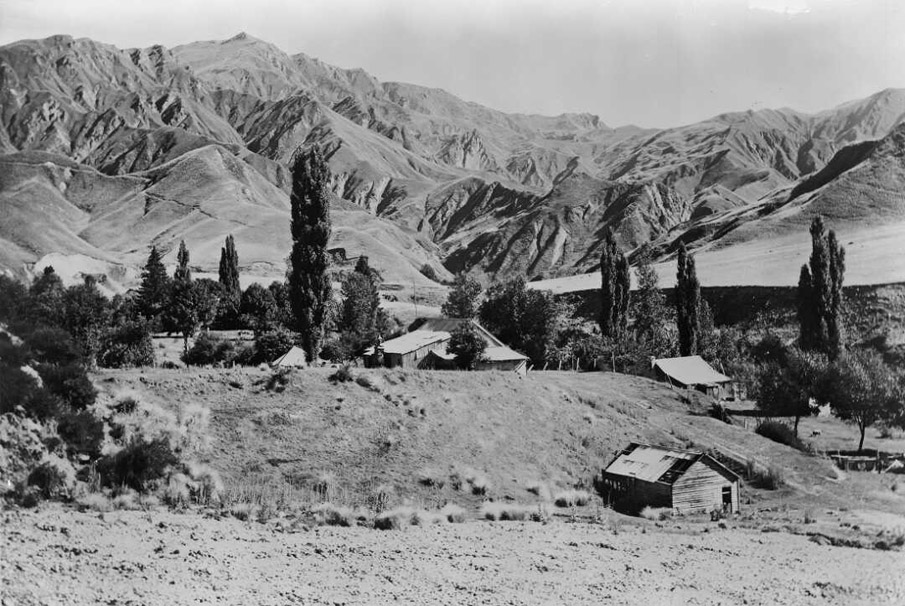
Social Significance or Value The settlement of Macetown was the home of the miners who worked the reefs in the area. An isolated place, a long and arduous trek over rough country from Queenstown, Macetown was the social centre for the remote community who lived in harsh conditions. The historic area commemorates that community and its hardy occupants who lived there from the 1860s and into the 1930s, and also recognises the later value as an historic attraction visited by both new Zealanders and international tourists.
Historic Significance
Historical Significance or Value In the mid to late nineteenth century New Zealand was a world leader in gold mining technology and also embraced new technology to make the extraction of gold more efficient and therefore more profitable. The search for ways of improving gold extraction led to the cutting edge of available technologies of the period. Macetown reflects the history of these changing technologies – from alluvial to hard rock mining, and the lives of the miners in this isolated community. The historic area also reflects the growing recognition of the importance of mining sites to the history of New Zealand as shown by part of the area being gazetted as an historic reserve.
Physical Significance
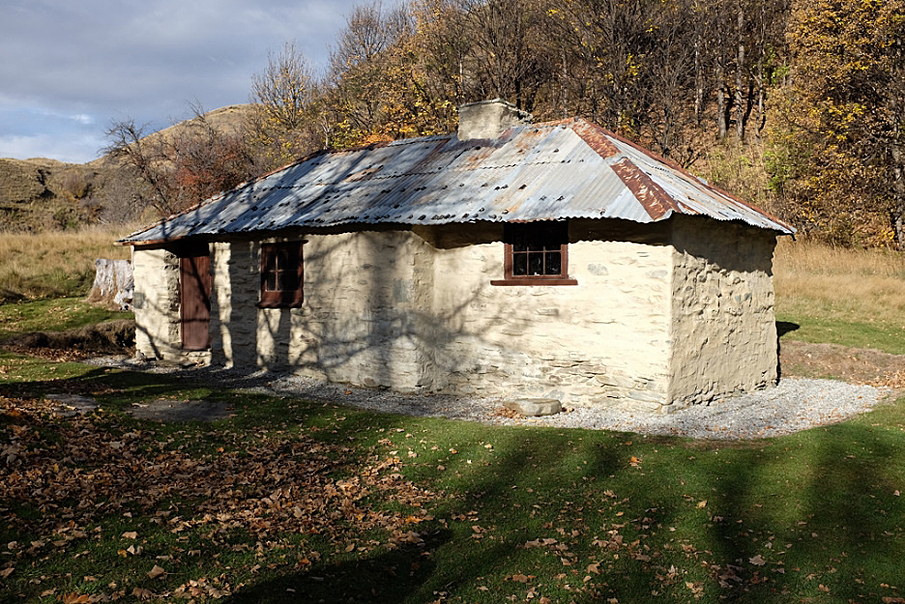
Aesthetic Significance or Value Macetown is located in the remote mountainous back country of the Queenstown district. The archaeological remnants are set around and upon the steep rocky faces of Advance Peak and the many gullies and ridge lines. This setting powerfully evokes the determination to find gold in this isolated and harsh environment, giving Macetown high aesthetic significance. Archaeological Significance or Value Macetown and surrounds are archaeologically rich, with a wealth of sites representing the life and work of miners and their families. The town itself has sites of numerous dwellings, commercial premises and other buildings, as well as cultural plantings. Surrounding the town site are alluvial gold workings, while the river terraces, gullies and hillsides bear archaeological evidence of both hard rock mining and hydraulic sluicing. Within Macetown there are 50 sites recorded by the NZAA, with these only being a small sample of the total amount of features likely to exist here. The hard rock mines are good examples of remote underground mining systems – with their mines, tramways, batteries and small settlements, and associated engineering works such as cableways. The mines and hut sites at Skytown and on Advance Peak are the highest in the country, and have the potential to provide information about mining technologies and working systems. Technological Significance or Value Macetown Historic Area contains evidence of the changing technologies associated with alluvial and hard rock mining in the nineteenth and twentieth centuries. The accessible and readable battery sites provide valuable evidence of these technologies and give the area technological significance.
Construction Details
Description
Gold found in the Arrow River
Finish Year
1862
Start Year
1862
Type
Other
Description
Macetown School opened
Finish Year
1870
Start Year
1870
Type
Original Construction
Description
Homeward Bound Battery opened at Tipperary Reef
Finish Year
1884
Start Year
1876
Type
Original Construction
Description
Road completed from Arrowtown to Macetown
Finish Year
1884
Start Year
1884
Type
Original Construction
Description
Premier Mine closed
Finish Year
1905
Start Year
1905
Type
Other
Description
Macetown School, Post Office closed
Finish Year
1916
Start Year
1916
Type
Other
Description
Depression era mining revival
Period
1930s
Type
Other
Description
Needham’s Cottage rebuilt
Finish Year
1979
Start Year
1979
Type
Reconstruction
Description
Macetown Historic Reserve gazetted
Finish Year
1980
Start Year
1980
Type
Other
Construction Materials
Stone (hut ruins), timber, iron, corrugated iron (battery ruins)
Iwi occupation Te Wai Pounamu has over a thousand years of Māori occupation including Whakatipu wai Māori (Lake Wakatipu). Ngāi Tahu whānui had developed a complex series of trails throughout Te Waipounamu over generations of occupation, connecting kāinga with one another and to mahinga kai (food gathering places) and other significant tribal resources. These ara tawhito (traditional travel routes) became the arteries of economic and social life and formed the relationships between people and places. Hunting moa, weka, eels, ducks, digging fern root and tī kōuka root, gathering taramea, and resources such as pounamu and silcrete, supported the thriving communities that were located close to Lake Wakatipu. Canoes and mōkihi (rafts) provided an important means of transport on the major lakes of Whakatipu wai Māori, Wānaka and Hāwea, particularly important in the trade and transport of pounamu from the inland to the coastal region where other significant communities were. Whakatipu wai Māori was always an important link in the pounamu trail from the southern coast, via Wakatipu wai Māori to the Inaka and koko tangiwai pounamu resources of the Greenstone/Caples Valleys and the Dart River Catchment. There was significant Māori occupation until the colonial land tenure was imposed from the Kemp purchase in 1848. Throughout their extensive Waitangi Tribunal Claim, Ngāi Tahu have always contended that the central alpine region including the lakes was not included in the sale. The significance of the area was acknowledged by the Crown who agreed it was appropriate for the lake to be overlaid with a Statutory Acknowledgement and Deed of Recognition status. Gold Macetown was established on a river terrace on the Arrow River upstream from Arrowtown after gold was found there in late 1862. It is commonly recounted that two independent parties, —the Mace brothers working up the Arrow River and the Beale brothers working over from Skippers Hill— converged on the spot almost simultaneously. In January 1863 miners overflowing from the Shotover and the Arrow goldfields moved into the area, and a settlement soon established, with alluvial mining in the river and stream beds and banks as its economic base. The higher river terraces were also worked once races were constructed to bring water to the claims. Macetown was initially named ‘the Twelve Mile’, this being the estimated distance of the location from Arrowtown (actually about 9 miles, 14.4 kilometres). By the 1870s the easily won alluvial gold was becoming worked out, and the miners’ attention turned to the local quartz reefs. These had been known for some time, but it was not until 1875 that any real prospecting work was carried out. The Government offered a pound-for-pound subsidy to prospect the area, and cut tracks to improve access. The first company to register was the Homeward Bound, the mine being opened up in 1876 by Messrs Raven and Barclay, who also erected the first crushing battery in the area. There were high expectations of the reefs: ‘There is very little doubt of the permanency of the Macetown reefs. They are almost an absolute certainty, and when once opened out can be worked very cheaply, consequent on water power being almost everywhere available, and the steepness of the hills obviating the necessity for hoisting of ore or water, while the facility for self-acting tramways is all that could reasonably be desired.’ However, from the earliest days it was recognised that the lack of access to the area was a serious hindrance to mining, as there was no road up the Arrow Gorge from the outside world. All supplies had to be packed in, at a cost of £5 per ton, or £10 per ton for heavy timber delivered to the mines. This increased the cost of mining, and severely limited the machinery that could be used. Nevertheless, the mines were opened, and equipment brought in, all at great expense. Despite repeated calls for the construction of a road, it was not until 1884 that one was completed from Arrowtown to Macetown, at a cost of £9,570. There was an immediate drop in the cost of supplies, particularly the timber essential for shoring up mine tunnels. However, the improved access came too late to save many of the original companies and their mines, of which only the Premier and Tipperary mines were still working. The lack of access was not the sole reason for the failure of most of the Macetown mines. Work was interrupted by the harsh winters typical of the area which brought snow and frozen water supplies, and by occasional flooding in the steep gullies. These events increased costs, but mismanagement and misrepresentation of claims’ worth to attract capital also took their toll. The 1876 Warden’s Report commented that: ‘A good deal of criticism has from time to time appeared in the public papers animadverting on the mismanagement, want of management, or excessive management, of the various companies....’ Most of the mines were held by a succession of owners, and were opened and closed on several occasions. Numerous efforts, some successful, were made to attract overseas investment, and many of the mines eventually ended up in the hands of a few large companies. But by the early twentieth century most of the mines were played out. The erection of the massive Homeward Bound Battery in 1910 was something of a swan song, to be followed only by the brief resurgence of Government-sponsored mining during the 1930s Depression. As mining was the single economic base of Macetown, the township did not long survive the closure of the mines. Many buildings that survived until the end of the Second World War were stripped in the post-war shortages of building materials. The first hanger for Southern Scenic Airways was built of Macetown iron in 1947. The Macetown Historic Reserve was surrendered from the Coronet Peak Pastoral Lease and gazetted as an historic reserve in 1980. Today, Macetown is a picturesque ghost town that has become a tourist attraction. History of Macetown The population of Macetown initially consisted of miners moving up the Arrow River or over the hills from the Shotover. Commercial operations were soon established at the Twelve Mile. The Mace brothers erected a large store in September 1863, which apparently joined a number of other similar establishments. The name change to ‘Macetown’ probably occurred gradually, its first public use being in February 1865, although the post office which opened in March 1865 was still called ‘Twelve Mile Creek’. The West Coast gold rush of 1865 led to an outflow of people, including the Mace Brothers, and a subsequent decline in the population, but enough people remained to keep the town alive. The Macetown School was opened in 1870 with a roll of 12 boys and 9 girls, but the population was in decline in the early 1870s, and in 1876 the government withdrew the subsidy for the teacher’s salary, although it was later reinstated. The development of the Macetown reefs in the late 1870s saw a gradual rise in the population again; in 1896 when 206 people were recorded in census figures, including 10 men and 4 women in Sawyer’s Gully and 15 men and 6 women in Scanlan’s Gully. There were also Chinese miners at Macetown, and there may have been a Chinese market gardener. An area of Chinese huts was located on the flat just east of Smith’s Store and bakehouse, where a photograph was taken of G.H. McNeur standing outside a hut with three Chinese men. Chinese miners were engaged in both alluvial mining (see the account of the Tipperary Mine below), and quartz mining. The merchant Choie Sew Hoy had an interest in a quartz claim in Sawyer’s Gully adjacent to the Premier mine. A problem for both the settlement and the mines was the lack of good road access to the outside world. The options available were either the Big Hill track or the Gorge track, and all goods and equipment had to be laboriously packed in. Residents and miners agitated repeatedly for the Government and the Lake County Council to construct a road, but by the time the road was completed in 1884 many of the mines had already closed down. The final decline of Macetown began when the Premier Mine closed in 1905. The Premier Mine was the last large-scale quartz mine that provided employment; the remaining small quartz mines and alluvial claims could not provide reliable work. Various schemes provided periods of optimism, such as the large-scale work carried out at the Homeward Bound Mine in 1909–-10, but a slow decline was inevitable in the face of mine failures. The school closed in 1916 and the Post Office and the telephone office closed within days of each other in 1916, although the latter was reopened from 1917 to 1921. After 1921 the town was abandoned except for William Jenkins (‘Billy Jenks’) whose mother had run the Alpine Hotel. During the 1930s Depression, a number of people moved back to Macetown, mining on Government subsidies. There were still a number of habitable buildings standing, together with plenty of firewood from the trees that had grown up in the area, and the road was again being maintained by the Lake County Council. As the Depression eased, miners and their families left, and the last resident was again William Jenkins. In the later years, the land reverted to pastoralism. The Macetown Road is popular with tourists with walkers, bikers and four wheel drive tours taking the road to Macetown where the historic reserve provides interpretation for visitors. In 2017, Macetown remains a significant attraction in this historic landscape.
Current Description The Arrow River rises to the south of Mount Motatapu in the Harris Mountains, and runs south to emerge into the Wakatipu Basin at Arrowtown, before finally meeting the Kawarau River. It mainly flows through mountainous country, with numerous small- and medium-sized tributaries, of which the most notable are Soho Creek, the Eight Mile Creek and the Rich Burn. An area of extensive natural river terraces at the confluence of the Arrow and the Rich Burn (also known as the Gold Burn or the Twelve Mile Creek) became the focus for alluvial gold mining operations as well as the site of the town of Macetown. Extensive alluvial workings were also located on the hillsides above the township, and in many places along the bed and banks of the river. The insides of many bends show evidence of small-scale alluvial mining. To the northwest of the site of Macetown, Advance Peak rises to a height of 1749 m. On the summit and just below it are the Advance Peak mines, which were the highest in New Zealand when they were in operation. To the south of Advance Peak and the Rich Burn, on the spurs of Vanguard Peak, are the main Macetown reefs, running roughly northwest to southeast. Several streams cross this area (Sawyers or Sawyer’s Creek or Gully, Sylvia Creek and Scanlan’s or Scanlan Gully), and both their banks and their intervening ridges contain extensive archaeological evidence of hard-rock mining systems. These streams feed into the Rich Burn, along the valley of which, the main access road to the mines ran. The country is generally open, with tussock and scattered speargrass being the usual vegetative covering. Matagouri and sweet briar are common in places, while broom is present but is controlled within the area of the historic reserve. Macetown Township The township was located along a mile of river terrace on the true right of the Arrow River. It had two main sections – the north-western end where the main community buildings were located, including hotels, school, bake house and stores; and the southwest end, which included Joseph Needham’s house, and about which less is known. The township site is archaeologically rich. Buildings sites are marked by terraces, levelled areas, chimney remains, and plantings. There are three standing buildings – a timber building at the south-eastern end of the town, Needham’s cottage (rebuilt by Department of Lands and Survey (which was later to form a part of the Department of Conservation c.1979) and Smith’s bake house. The last two have been restored by the Department of Conservation. There are substantial ruins – a small stone ruin close to the timber building, and the Alpine Hotel stables. The area of the Macetown settlement is well known for its cultural plantings of exotic trees, with daffodils and bluebells appearing in the spring. While a number of fruit trees still bear fruit, it is noticeable that many of them are becoming old and dying, and are being replaced by more vigorous exotic species such as sycamores. The cultural plantings are of significance – large deciduous trees, spring daffodils, largely confined to their original beds, some of which define paths to house sites. Hawthorn hedge plantings are still evident. Where the Macetown track branches at the Rich Burn, one branch leads onto Cemetery Terrace (F41/489), the site of the Catholic Church and the Cemetery Reserve. There are reputedly occupied graves remaining in the cemetery, although the majority of the bodies were removed and reburied at Arrowtown Cemetery. The ridge track to Advance Peak climbs up the hillside. There are extensive areas of ground sluicing nearby. Returning to the township, the track carries on to the west, and above the ford were the huts of the ‘twelve apostles’, old miners renowned for their drinking binges. Macetown Terraces and Alluvial Mining The first workings were in the river bed and river beaches, before miners turned their attention to higher terraces on the western side of the valley. A lack of water led to tunnelling, to extract gold-bearing gravels for later washing. Many areas were not mined until long races were built to bring water to the claims from creeks further upstream. Hydraulic sluicing increased the area that could be worked. As detailed, quartz (hard rock) mining became dominant in Macetown in the later years of the nineteenth century. There is archaeological evidence of these mining methods on the terraces and gullies surrounding Macetown. Evidence of alluvial mining can be found on the hillside above Macetown on the western side of the valley, as well as on the river terraces on both sides of the river at the confluence of the Arrow and the Rich Burn. The workings are concentrated in a band running parallel to the Arrow River, extending c.600m up the hillside. These are typically the remains of a number of high water races running around the hillsides, below which are the upper sluice faces of the claims, running down to tail races and piles of tailings. The alluvial mining landscape shows the effects of ground sluicing (with water races at low levels and stacked tailings below shallow sluice faces) and hydraulic sluicing (with high level water races and high sluice faces). Both systems often used reservoirs for water storage. Hut sites are often found amidst the tailings. Rich Burn (also known as Twelve Mile Creek or Gold Burn) Sites The valley of the Rich Burn contains a number of mining sites, and links with the many mines in the gullies and hills. The track between Macetown and the more distant mines (and onto Advance Peak) ran through the Rich Burn valley. Six stamping batteries were located by the Rich Burn – the Public, Anderson’s, Homeward Bound (three different batteries serving the same mine); and the Sunrise. They served the hard-rock mines in the surrounding hills. Evidence of alluvial mining remains such as ground sluicing, as well as the remains of tailings, huts sites, and tail races. Residence sites include the site of the ‘Twelve Apostles’ mentioned earlier and other huts sites. The battery sites were the most prominent, in particular the Homeward Bound Mine and Battery. This was the first quartz-reef mining company to register at Macetown when it opened the Tipperary reef in 1876. The archaeological evidence consists of three battery sites, the aerial cableway, the mines and a track climbing the hillside above the second battery site. Macetown The township straggled nearly a mile along the one main road, being constrained by its site on the long narrow river terrace. It appears to have had two main sections: the north western end with the main community buildings such as the hotels, school, bakehouse and stores; and the south eastern end, which includes Joseph Needham’s house (F41/493, Extent Map No. 25) but is otherwise not well documented. The whole area was surveyed in 1878, but the survey plan shows structures only at the north western end. The site of Macetown is archaeologically very rich. As the area is actively managed and receives large numbers of visitors in four-wheel-drive vehicles, it is generally quite ‘tidy’, without much small artefactual material scattered about. Sites within Macetown Over the years there were a large number of buildings erected at Macetown, including numerous residences, several hotels, stores, a bakehouse, a school, a post office and a hall. The archaeological remains of a number of these can be positively identified on the ground. Some of these sites are described below, starting from the south eastern end of the township, where the road climbs up from the river bed to the location of the first modern interpretation sign. On the left (south west of the road) is the only remaining timber building in the township. Its history is unknown. Beside this building, past some old gnarled willows, are several house and hut sites, the largest of which has the daffodil pathway mentioned above. There are several other hut sites, the remains of an orchard, and a stone wall fronting the road. On the other side of the road (north east) from the wooden building is a large area of ground sluicing. Fifty metres past the stone wall just mentioned there is a small square stone structure set immediately above and southwest of the road. It is in good condition, although the roof is missing. Two hundred and fifty metres further on, on a terrace below and to the northeast of the road, is Needham’s cottage (F41/493). Joseph Needham was the schoolmaster at Macetown from 1879 until 1889, after which he stayed in Macetown goldmining. The cottage was substantially rebuilt by the Department of Lands and Survey c. 1979. Two hundred metres on the road drops down a steep cutting. To the northeast is an area of ground sluicing tailings with shallow dams. There are several hut sites on this terrace, known to have been inhabited by Chinese miners. An interpretation panel shows one hut when it was inhabited, together with its occupants and G.H. McNeur. The road then climbs again to the site of the Macetown memorial and a series of interpretation panels. These stand on the site of Smith’s store. Just behind them (to the southwest) is the site of Smith’s bakehouse. This was also rebuilt by the Department of Lands and Survey. Just beyond the store site was the Macetown Hotel. This was initially owned by Joseph la Franchi, then sold in 1873 to the Italian Resta brothers, and later passed through the hands of Edmund Elliott, George Spooner, a Mrs Elliott and Robert Gilmore. It was finally bought in 1905 by John McLeay before being destroyed by fire in 1906. Almost directly opposite the Macetown Hotel (on the northeast side of the road) was the Alpine Hotel (F41/490, Extent Map No.22). Its site can be identified by the substantial ruins of the stables which stood behind the hotel. It was opened in 1883 by a Mr Dyson, was later operated, for a short time, by William Jenkins, and then by Mary Illingworth. By 1905 James Anderson had the licence, and the Alpine was the only operating hotel left in Macetown. It was then run for a time as an accommodation house, before finally closing in 1918. Past the Alpine Hotel (still on the northeastern side of the road) were the Public Hall, the school, the Post Office and the school residence. The school was opened on 7 February 1870. The building, constructed the previous year, measured 22 feet by 14 feet (6.7 by 4.3 metres). In 1895 a new school building was erected, the old building being retained as a playhouse. The school finally closed in 1916. The Public Hall was opened in March 1899, with a large ball held to celebrate the opening. A number of other house, hut, and business sites and access lanes are scattered on either side of the road as one continues along. Revetted banks and remains of gardens mark several of these just past the small stream. The road then drops down a cutting towards the Rich Burn, where the track branches. From this junction, the north eastern track crosses the Rich Burn, and another stream to lead round to a track cut up onto Cemetery Terrace. This was the location of the Catholic Church and the Cemetery Reserve. The Catholic Church was established during the first year of the settlement. However, by 1865 the building had fallen into disrepair. The 1878 plan of Macetown still shows a building on this spot, although it is not certain how long it survived. The graveyard was located near the church, and two graves are reputed to be still occupied, although most of the bodies have been removed to the Arrowtown Cemetery. The ridge track to Advance Peak climbs up the hillside close to the church and cemetery site. The edges of the terrace have been extensively worked by ground sluicing. The track continues to the north, to the site of Granny Barker’s house, on a terrace above the Arrow River. The house site is marked by the remains of a stone chimney and numerous trees. A line of dead fruit trees is present below the existing vegetation. Returning to the main road at the end of the township, if one carries on along the road to the west, rather than turning northeast to go to Cemetery Flat, it continues onto a ford in the stream. To the southwest, above the ford, were the huts of the ‘Twelve Apostles. Over the ford, the road continues up the Rich Burn. Rich Burn Sites The valley of the Rich Burn (or Twelve Mile Creek or Gold Burn) contained a number of mining sites in its own right, and also provided a link between the numerous mines in the adjoining gullies and hills. The main track between Macetown and the mines, ultimately leading to Advance Peak, ran along the valley. In addition, six stamping batteries: the Public, Anderson’s, Homeward Bound (which consisted of three different batteries serving the same mine at different times) and the Sunrise, were all located by the Rich Burn, close to this track. These served the hard-rock mines in the surrounding hills. Thus both alluvial and quartz reef (hard-rock) gold was mined in this area. The alluvial mining sites in the Rich Burn are typical of the area, where ground sluicing technology was used to work small areas of ground above the valley floor. The archaeological remains of this activity include piles of tailings, tail races and scattered hut sites. The main archaeological sites in the Rich Burn are discussed below, heading upstream (west) from the confluence with the Arrow River. The Twelve Apostles This is the site of the huts of the ‘Twelve Apostles’ (Macetown) - twelve old miners renowned for their drinking binges as previously noted. More information about them is available in Beaton. The huts were located on the true right bank of the Rich Burn, beside the first ford of the main track up the stream. Alluvial Mining Along the valley sides of the Rich Burn are sluice faces and heaps of tailings from ground sluicing operations. On the true left bank are the sluice faces cut back into the Cemetery Flat terrace, while on the true right bank are scattered areas of overgrown tailings. Public Battery The Public Battery was constructed by the Macetown Crushing Company in order to fulfil a need for a general battery. The company consisted mainly of local shareholders, and the battery was erected in 1877 on a terrace about a quarter of a mile upstream from the township. It consisted of ten 6-cwt stampers powered by a Greenlaw’s turbine. However, there were complaints that it was located too far from the mines, and there were calls to relocate it near the Lady Fayre ground. Nothing came of this, and in December 1882 tenders were called for the removal of the plant. Nothing remains on the site to identify it today. It was probably located on the true left of the stream, between 100 and 200 m upstream from the first main ford on the track. Concrete Foundations Located on a terrace above the true right bank of the stream are several concrete foundations. One appears to be an engine bed, while the others are of uncertain use. It appears that they were housed in a small building, and may have been built during the last main period of activity at Macetown in the 1930s Depression. Anderson’s Battery Anderson’s Battery is located beside the Rich Burn, at the mouth of Scanlan’s Gully. The vehicle track up the Rich Burn finishes at the battery, where there is plenty of space for parking. The old road (now only passable on foot) continues up the Rich Burn. A vehicle barrier is located about 100 m further on to prevent the use of four-wheel-drives and motorcycles. Alluvial Workings and Hut Site Shortly beyond the first ford after the vehicle barrier, two areas of alluvial workings are located on the true right bank, across the creek from the track. These are located on terraces well above the level of both the stream and the track. The first area is only about 20 m by 20 m, and sits atop a bluff projecting out into the valley. It contains a small hut site. The second area is much larger, 100 m long by 25 m wide, 100 m long by 25 m wide. It also contains a hut site, although most of the area is taken up by piles of tailings and several tail races. Hut Sites About 150 m past the hanging valley, three hut sites are located on a level area above the track. One hut site is marked by a stone chimney, which has half fallen away. The huts are not visible from the track. Sylvia Creek At the confluence of the Rich Burn and Sylvia Creek the track branches. The sites located up Sylvia Creek (including the United Goldfields and All Nations batteries) are described later in the report. The main Rich Burn track continues up the valley to the Homeward Bound Battery. Homeward Bound Mine and Battery The Homeward Bound Company was the first quartz-reef mining company to register at Macetown, with a claim on the Premier lode (although the Tipperary reef, see below, was found first). While opening up the mine in 1876, Messrs Raven and Barclay won 551 oz. of gold from 542 tons of stone. They erected the first battery in the Macetown area —the ‘Little Wonder’— in March 1876. This was a small mill of four stamps, erected to test the value of the reef. Its first crushing produced 10 oz 16 dwts of gold from 2 tons of quartz. The floods of 1878 swept away the mine office and stables and silted up the battery. This led to its replacement by a more powerful five-stamp battery located comfortably above the stream flood level. A self-acting tramway was also constructed to take ore to the mill from the mine, a distance of 22 chains (442.5 metres). The following year, a further ten stamp heads were added to the battery. The mine was operated on three levels. The top two levels were payable, but the third (lowest) level was not. Disaster struck in November 1883 when a slip caused by heavy rain completely destroyed the tramway to the battery. The company was wound up in 1884, the mine passing into the hands of Messrs Gage and Co. of Dunedin. They carried out some prospecting, but found nothing worthwhile. The mine was later acquired by Farrell’s New Zealand Consolidated Gold-mines (Limited), and in 1909 it was announced that payable quartz had again been located, and work began on the construction of a new aerial cableway from the mines down to the Twelve Mile Creek (Rich Burn). The following year the large OPQ (Otago Pioneer Quartz) stamping battery at Waipori was dismantled and transported to the site where it (the third Homeward Bound Battery) still stands. Between 1908 and 1911 stone from the Homeward Bound, All Nations and Garibaldi mines was crushed either in this battery or in a small composite battery in Bush Creek (possibly the United Goldfields Battery). The outbreak of war in 1914 brought a complete cessation of funds from London, and all work was stopped in the claims. Some prospecting work was carried out in 1935, with one of the old levels being reopened, but this appears to have been the last activity at the mine. Archaeological description The archaeological evidence of the Homeward Bound mines consists of three battery sites, the aerial cableway, the mines and a track climbing the hillside above the second battery site. When walking up the Rich Burn, the first feature to come into view is the large battery. This is the third Homeward Bound Battery, moved to the site from Waipori in 1910. It is a ten-stamp mill, manufactured by the Sandycroft Foundry of Chester, England. The heavy frame timbers still bear the marks cut into them to aid reassembly. Extensive stabilisation and timber preservation work has recently been carried out on the structure, including the construction of a roof. Scattered around are various items of battery plant, including a berdan and a disassembled Wilfley concentrating table. A jaw rock crusher is sitting in the battery structure, although it was originally mounted to the rear and above the mill. The battery was originally housed in an iron and timber battery shed, of which nothing now remains. Contemporary photographs show it complete, and at a later date when the iron had been stripped away. The two battery sites of the first Homeward Bound Company (1876–-84) were located nearby, on either side of a small gully just past the surviving battery. The ‘Little Wonder’ of 1876 was down near stream level, and while the site was marked by a few pieces of rusting iron when visited in 1993, subsequent flooding has obscured any evidence. The site of the second battery (1879-–84) is on a terrace above the Rich Burn. The site currently consists of a terrace cut into the hillside, with scattered sections of corrugated iron, tins and pieces of cast iron. No items of machinery remain, but the end of the head race and the outflow of the tail race can both be found, each cut into the rock. The tail race discharged straight over the rock face, into the stream below. Above the existing battery structure is the site of the ore hopper and terminus of the aerial cableway. The cableway pylons with their cast iron guidewheels follow a straight line up the hill to the site of the top ore hopper and cableway return wheel. The return wheel is very similar in design to the return wheel at Skytown. On the hillside above the hopper is the mullock heap from the upper levels of the mine, one drive of which is still open. Climbing the hillside to the north of the cableway is a zig-zag track which ascends to the ridge top. From there an indistinct track can be followed which leads to the series of workings along the line of strike, including the Lady Fayre shaft and the Golden Link, before dropping into Sawyer’s Gully and the site of the Maryborough/Premier operation. Sunrise Battery Site and Office The history of the Sunrise Mine is described below. The mines were located high up the mountain, while the battery was built much lower down beside the Rich Burn, some 600m upstream from the Homeward Bound site. Archaeological description The site of the Sunrise Battery and the surviving office building is on the true right of the Rich Burn, near the confluence with Advance Creek. The battery site consists of a level area beside the creek, protected from erosion by revetment. There is a line of schist piles built along the back of the terrace. The machinery has been removed (and partly comprises what is now Anderson’s Battery), and so little remains on site. There are a few stamper shoes scattered about. The mine office is located just upstream of the battery site. It is a small weatherboard building with a corrugated iron roof. Floods have regularly washed through it and gravel has accumulated around and in the building so that the ground level is now at the base of the windows. On the other side of the stream from the building, at the confluence of Advance Creek and the Rich Burn, is the pipe inlet structure for the Homeward Bound pipeline that supplied water to the third (existing) battery. The pipes themselves have long since been removed. Hut Sites and Track to Advance Peak About 700 m upstream from the Sunrise office the track forks, the upper branch climbing up to Advance Peak, and the lower branch continuing on towards the Premier Mine in Sawyer’s Gully. At least five hut sites were located near the fork in the track, four on the true left and one on the true right of the Rich Burn. It is not clear whether these huts were associated with the Premier Mine or some of the Advance Peak workings, although it is possible that they were used by a mixture of miners from the various companies working in the area. Scanlan’s Gully A number of mines operated in Scanlan’s Gully (sometimes Scanlan Gully or Scanlon’s Gully) and its branches, of which the largest and most profitable was the Tipperary. Others were Anderson’s Mt. Verde Mine and Balch’s Mine. The Tipperary Mine The Tipperary Reef was the first main line of lode opened at Macetown, and the Tipperary Mine was to become one of the most productive of the Macetown quartz mines. The lode was first opened out in 1875-–76 by Thomas Hall. Two versions of the discovery exist. Veitch recounts that Hall pegged out the most promising outcrop in the valley, and then allowed a group of Chinese miners to sluice away the soil overlying the lode, thus getting the ground opened out at no cost and only a little loss of gold. Ng gives a similar account. Miller gives a slightly different version, whereby Hall followed a trail of dirty water coming down Scanlan’s Gully, finding a small group of Chinese miners sluicing away the free gold on the cap of the reef, unaware of their discovery. Hall quickly pegged out the reef. Whichever version is correct, Hall was apparently guilty of some dubious business practices, and the mine was embroiled in litigation until the beginning of 1878. It then produced some very good returns, including a 501 oz cake of gold in December 1881. In 1879 a battery was constructed in Scanlan’s Gully. It consisted of ten heads of stamps, a berdan and a buddle, driven by a Whitlaw water turbine 3 ft in diameter. Until that time much of the Tipperary ore had been crushed at the Public Battery. To raise ore in the mine, a water balance was constructed. This consisted of a wheeled tank placed on an inclined tramway with the same length as the depth of the shaft in the mine. The tank was filled with water at the top of the incline, and was then allowed to descend to the bottom. The tank was connected by a cable to a box in the shaft, in which the ore was placed. The descending tank raised the ore, and then the tank was emptied and was drawn again to the top of the incline by the descending ore box in the shaft, ready for another load. Although this was ingenious, it was too slow in operation for the efficient working of the mine. This, amongst other problems, caused the mine to close in 1888. It was reopened in 1893 after the West Argentine (Westralia) Gold Company (Ltd) was floated and raised the capital to start operations. The mine was put back into working order and a tramway laid to the battery. Work in the upper levels of the mine was suspended, and a low-level adit was constructed, reaching a length of 1927 ft (587 metres) before the old workings were encountered in February 1886. The company also constructed a furnace at the battery with which to fire the concentrates after processing in an attempt to improve gold recovery. This was finished in January 1897. In 1898 a new winding plant was installed to raise ore from the lower workings to the main adit. A 20 hp oil engine was installed in a winding chamber measuring 30 ft by 9 ft (9 by 2.7 metres), located 2000 ft (690 metres) underground. Unfortunately, the fumes from the engine made the mine unworkable, and despite some modifications, including a change in fuel, the delays and expense in the scheme caused the mine to be shut down again. In 1903 the Indian Glenrock Company took over the mine and repair work commenced. It was found that the chamber on the hauling shaft had broken down, and the tramway had been damaged by floods. The mine was once again shut down in 1905, this time due to other problems within the company that owned it. Balch’s Mine Balch’s Reef (the New Caledonia) was discovered in Caledonian Gully, off Scanlan’s Gully, by Richard Balch in 1905. An early crushing of 25 tons of quartz yielded 52 oz 10 dwts of gold, and this encouraged further work. The good yields lasted for a while, with crushing being carried out at the old Tipperary Battery, but by 1907 the stone had given out, and work ceased. The mine was sold to the Anderson brothers. Above the Sunrise office the upper branch of the track climbs to Advance Peak, while the lower branch continues toward the Premier Mine in Sawyer’s Gully. There are hut sites located near the fork in the track. Scanlan’s Gully A number of mines operated in Scanlan’s Gully. The largest was the Tipperary Mine. The archaeological evidence starts at Anderson’s Battery site. The Battery is iron-framed, the only one of its kind in Otago. It was built as a ten stamp battery; one set of stampers has been removed. The berdan, used for fine grinding, remains. Some stone revetting remains for the road. The Tipperary Battery site and furnace are located c.500m above the gully on the true left of the stream. No machinery remains on site, but there is a revetted embankment and stone furnace. The open lower drive of the mine and a small timber and iron hut remains just short of the Caledonian Gully confluence. A track leads up to a number of collapsed drive locations. The location of the Tipperary low-level drive is further upstream. Close by is the site of the blacksmith’s forge. In front of these features can be seen the formation of the Tipperary tramway. There are nearly twenty hut sites nearby. Anderson, Hannah and Party Anderson and Hannah’s claim, the ‘Mt Verde Mine’, was situated at the junction of Scanlan’s and Caledonian Gullies. In 1907 they purchased the old Sunrise Battery (then owned by the Premier Mine, and possibly moved up to that site) and transported it down to the junction of Scanlan’s Gully and the Twelve Mile Creek (Rich Burn), where it still stands today. Work continued intermittently until about 1910, one of the problems being lack of water to drive the battery. The mine was briefly reopened by the United Goldfields of New Zealand Company after the First World War, and a new level driven, but work was abandoned in 1921. Archaeological Evidence in Scanlan’s Gully The track up Scanlan’s Gully starts at Anderson’s Battery site. The battery is iron-framed, and is the only one of its kind in Otago. Built as a ten stamp battery (two sets of five stamps), one set of stamper shafts has been removed, and the shafts are presently lying on the ground beside the structure. The battery was powered by a Pelton wheel, which has been removed since the 1970s, although the iron casing for the wheel remains. The berdan, used for fine grinding, is still in situ in line with the end of the stamper camshaft, from which it was driven via a canvas belt. The battery and equipment stands in the open, although the battery shed survived until the 1970s. Photographs show it as a weatherboard building with an iron roof. Exposure to the elements is causing decay of the remaining timber elements (berdan frame, battery tables and pulleys), with noticeable deterioration between 1993 and 2000. At the mouth of Scanlan’s Gully there is some revetment on either side of the creek. Some of this is associated with the road that ran up the gully. As one walks up the gully, sections of the carefully built road are obvious, with revetment both beside and below the road in places. Some parts of the road have been destroyed either by slips or by stream erosion. Tipperary Battery Site The Tipperary Battery site and furnace are located about 500 m up the gully, on the true left of the stream. Floods in November 1999 badly damaged the site, depositing a thick layer of gravel and washing away the old stream banks. No machinery remains on site. There is a revetted embankment, which was probably where the ore was fed down into the stampers. The stone furnace, located beside the battery site, is still partly standing, although the stonework is becoming increasingly decrepit. The Tipperary Mine tramway led upstream from the battery to the mine, but the section between the battery and Caledonian Gully is not well preserved. A short distance beyond the battery there is a structure cut into the true right bank, consisting of several old stamper rods used to support a portal or roof. It could be an adit or drive entrance, although there is no record of a mine at this location. Just short of the Caledonian Gully confluence, on the true left bank, is the open lower drive of Anderson’s Mine and a small timber and iron hut containing a number of galvanised iron pipes (probably for underground mine ventilation). Around in Caledonian Gully a zig-zag track climbs up the hillside to a number of collapsed drive locations (probably the upper levels of Anderson’s Mine and at least one hut site). Ore was sent to the valley floor from the upper drive along a chute, part of which was cut through a rock knob. There is some archaeological evidence that a short aerial cableway may have been employed at some time. Just upstream of Caledonian Gully is the location of the Tipperary low-level drive. Although it has caved in, the location is obvious as orange-stained water continues to seep out of the old workings. Close by the drive is the site of the blacksmith’s forge, with fragments of clinker and slag scattered about. In front of the low-level drive and the blacksmith’s the formation of the Tipperay tramway can be seen. It is well preserved from this point up almost as far as the mine site. It runs along the true left of the creek, and in places has been carefully revetted to protect it from erosion. On the opposite bank of the stream seven hut sites were identified, two of which comprised substantial stone ruins. Five further hut sites were clustered on the same side as the tramway at the confluence of Scanlan’s Gully and Tipperary Gully. Two of these are on the true right of the Tipperary Creek, on a small terrace. The other three are on the other side of the creek, on a sloping terrace. The remains of a Shacklock cast iron coal range are sitting close to one site. The tramway formation continues up Tipperary Gully, although slips and erosion have now destroyed much of it. A further three hut sites are located well above the gully floor on the true right of the stream. The unstable nature of the rock means that very little remains to be seen of the Tipperary Mine. This hillside was prone to slipping even when the mine was in operation. At the base of the hillside there is a jumble of coils of wire rope, timbers, ironwork and revetment, confirming that much archaeological material lies buried and mixed in the slip material. Several short water races are visible on the opposite side of the gully. Sylvia Creek A number of mining operations were based in Sylvia Creek and one of its tributaries, Bush Creek. The remains of two batteries—the United Goldfields and the All Nations—stand on the banks of the creek, and the remains of an impressive aerial cableway climb up from the valley to the site of ‘Skytown’, a small cluster of huts and mines at high altitude. The All Nations Company The All Nations Company is first mentioned in the Warden’s Report for 1876. The company had driven both a tunnel and a shallow shaft to meet a reef that was expected to yield 4 to 6 oz of gold per ton. By 1878 expectations were still optimistic, but down to 1 oz per ton. The company by that stage had erected their own crushing battery, described as: ‘A four-stamper battery, situate about half a mile from the claim. The machinery is very compact, having full power and weight, and attached is some very ingeniously constructed apparatus for dealing with the tailings by means of a concentrator and amalgam barrel.’ Crushing was held up in late 1878 due to flooding that hindered all the local enterprises, but by the end of March 1879 work had recommenced. Expectations were still for rich returns, as the last crushing before the flooding had yielded over 1½ oz per ton. At registration, the company had been fully paid up with £28,000 in £1 shares. However, this proved insufficient and the company fell into debt. In 1881 it was reconstructed as the New All Nations. By 1885 it was one of the only three quartz reef mining companies still operating at Macetown (along with the Tipperary and Premier), but its work was only of a prospecting nature. In 1888 the reconstructed company went into liquidation. The battery was left on site, and was later repaired and put to use by the New Garibaldi Company working the Garibaldi claim, which bordered the All Nations claim. This venture met with no success. Subsequently, the battery was partially covered by a slip, and was abandoned for a time. Then, in 1895, it was cleared and repaired by Messrs Grinstead, Ford, Elliot and Pitt, who were working the old Victor Emmanuel claim in an attempt to attract investment from London. Once again, this venture was not successful, as no payable stone was found. In 1913, New Zealand Consolidated Mines, which had recently re-opened the Garibaldi and Homeward Bound workings, commenced work at the All Nations. An aerial cableway was constructed, this being the one that can still be found. Work had ceased by 1920. Garibaldi Mine The Garibaldi lode was discovered and opened up by October 1877, and in 1878 a tunnel was driven, but little good stone was struck. In 1880, the Garibaldi Gold Mining Company was registered to reopen the lode, and some good blocks of stone were struck. However, the ore had to be sledged down to Bush Creek and then taken by dray to a battery, which added greatly to the expense. In 1887 the lease and property were sold by the bailiff of the Queenstown Warden’s Court, and soon after that the claim was incorporated into Farrell’s Consolidated Mines. The mine was reopened by New Zealand Consolidated Mines (Limited) (later the United Goldfields Mining Company) between 1909 and 1919. Victor Emmanuel Company The Victor Emmanuel Quartz Mining and Crushing Company was set up in 1876, and although work on the mine got underway, no battery was constructed and the ore was crushed at the All Nations Battery. The mine produced some promising results, but was closed down and sold in 1881. The mine was opened again in about 1894, and the All Nations Battery dug out from under a slip and repaired. This work was undertaken on tribute in an attempt to attract investment from London. This was not successful, and the mine again closed down. United Goldfields Battery This battery, constructed from parts of other batteries, was erected by the United Goldfields Company of New Zealand in about 1910 to rework the All Nations and Garibaldi mines. Archaeological Evidence in Sylvia Creek The walking track up Sylvia Creek once followed the old mine track formation, but this has now been largely destroyed by erosion and flooding. About 200 m up the creek, on the true right, there is a small section of revetment let into the bank, with a possible hut terrace above. Four hundred metres further on are the United Goldfields Battery and an associated building terrace. The battery is intact, but is becoming quite decrepit. A small slip has come down behind the battery, while the stream is eroding the ground in front of the structure. The battery is unusual in that it has concrete foundations, timber being more commonly used. This may be related to its relatively late date of construction (1910). Above the United Goldfields Battery the original mine road survives in sections, and leads on to the All Nations Battery 200 m further up the valley. Just before the battery is reached, there is a building terrace cut out beside the track which contained at least one hut or building site. The site of the All Nations Battery is on the true right bank of Sylvia Creek. It consists of the remains of the battery and water wheel, although these are quite decrepit). The head race is clearly defined, meeting with Sylvia Creek a short distance upstream, past the site of an old smithy on the opposite bank. The blacksmith’s is a stone building, and still contains parts of a cast iron portable forge and blower. The remains of posts in the ground beside the building indicate that there was originally a small cluster of structures at the site. The beginning of the track up Bush Creek to Skytown (see below) leads up behind these building sites. On the other side of the valley (east side) there are at least four hut sites cut into the hillside. A short benched track leads to the upper two huts. Above these is one of the long water races that supplied water to the sluicings above Macetown. Some of the timber framework to support fluming survives around a bluff directly above the site of some of the huts. Also visible is the bottom of the aerial cableway which carried ore to the battery. The cableway pylons can be seen on spurs leading up into the mountains. At the top of the cableway is ‘Skytown’. Skytown ‘Skytown’ was the unofficial name given to the small settlement of huts near the All Nations and Garibaldi mines and the head of the All Nations cableway in the head of Bush Creek. The derivation of the name is obvious once the site has been visited. The track from the All Nations Battery and smithy climbs up the north bank of Bush Creek, past the paved floor of a hut, and then crosses the creek to climb steeply up to Skytown. Parts of the track have slipped away, and much care is required as there are some very steep drops. Not located during the present survey was the Victor Emmanuel Mine, which was situated on the hillside near the start of the track. Two contemporary photographs of Skytown show, firstly, its location high above Bush Creek and, secondly, the steepness of the site. From the track the pylons of the aerial cableway are visible on the opposite side of the valley, as is the route of a slightly lower track or cableway. The exact nature of this lower feature is unclear, but heavy cables strung across a crevasse indicate that some effort went into its construction. It presumably pre-dates the main cableway, and was for transporting ore to the battery. At Skytown, the track first leads to the intact top return wheel of the aerial cableway and the partially collapsed quartz hopper, which is still full of quartz. The return wheel structure is in very good condition, although one cable guide wheel is missing. It is very similar to the Homeward Bound top return wheel , which was built at the same time by the same company, New Zealand Consolidated Mines (Limited), presumably using the same plans and parts. Nearby are the mines and the site of Skytown. Several hut sites can be easily found, set out in a row beneath a bluff. These huts are shown in one of the only contemporary photographs of Skytown. Below the huts there is a tramway or track bench, which ran between the ore hopper and the bottom of the short Garibaldi Mine cableway. Other tracks link the various mine workings in the area, of which the main two were the All Nations and Garibaldi. On the hillside above the hut sites is an open adit and the top return wheel for a small cableway. This is probably part of the Garibaldi Mine complex. Sawyer’s Gully Maryborough/Premier Mine Sawyer’s Gully (also called Sawyers Gully and Sawyer’s or Sawyers Creek) was the location of several mining operations, the largest and most enduring of which was the Maryborough/Premier mine. Other companies and mines included the Gladstone and General Havelock. The Maryborough Mine The Maryborough Company was registered in 1876, working on the Tipperary lode line. The 1876 Warden’s Report stated that the company was ‘engaged in sinking a shaft on the line of the reef, or rather following the lode down’. In 1878 the company erected a crushing mill at Sawyer’s Gully, of five stamps driven by a 30 foot (9 metre) water wheel. It did not start operation until late 1879, because of damage by floods in September, 1878. In 1882 the company was reported to have averaged some 4 oz of gold per ton from some 300 tons of ore, but these good returns cannot have continued as by 1886 it had passed into liquidation. The plant was purchased by the neighbouring Premier Company for £792/3/-. By this time the battery had been extended to ten stamps, each weighing 7 cwt, and was equipped with one berdan. The 30 foot (9 metre) overshot water wheel still provided the power. The Premier Mine The Premier Company also started work in the late 1870s. It did not erect a battery, instead doing its crushing at the Maryborough Battery until it bought that plant. In 1890 the Premier Company went into liquidation and was floated on the London market. It was taken up by the Glenrock Company, and was reconstructed as the Premier Consolidated Company. A new low-level drive was constructed from the level of the creek to improve the operation of the mine. In late 1891 the water wheel was replaced by a 6 foot (1.8 metre) Pelton wheel. In 1893 a further ten heads of stamps were added to the mill, and a cyanide plant was erected, consisting of ‘two circular solution vats, one sump, and a tank for making the solution up to the required strength’. The extra stamps possibly came from the nearby Sunrise Battery, which was purchased in 1893 for £750. During 1892 and 1893 a tramway was constructed from the Premier Mine down the gully to an ore hopper, and then from the bottom of the ore hopper a second line ran to the top of the battery. These features are still obvious. By late 1894, another new low-level drive was completed, and all outside works finished, but the parent company, the Glenrock Company Limited, stopped all payments. Work in the mine ceased in November 1894, and it was sold in February 1895 at auction. After a failed attempt by Farrell (of New Zealand Consolidated Goldmines) to buy the mine, it was sold to the Glenrock Company, who now had sole ownership. Work recommenced. In October 1895 an electric winch was installed at the mine for hauling ore, powered by a generator running off the mill shaft. By 1897, the battery consisted of 30 stampers, arranged in two separate mills but apparently all running off the same Pelton wheel. Periodic water shortages meant that the crushers and hauling equipment could not always be run at the same time, so in 1903 a separate power house was built. This measured 30 ft by 10 ft (9.1 by 3 metres) and housed a turbine working under 200 feet (61 metres) of vertical pressure, driving a dynamo. By this time the mine was beginning to face other problems. The depth of the workings —some 3100 feet (945 metres) from the surface— combined with the age of some of the timbering, was causing difficulties with tunnel stability. Two men were employed repairing and renewing timbering. There were also problems with ventilation and the power supply. The company underwent a series of restructurings under Glenrock ownership, until in 1903 the Premier-Sunrise (N.Z.) Gold Mining Company (Ltd) purchased the mine. Near the end of 1904 the good run of stone that the deep workings were following cut out, and despite attempts to relocate more good stone, it was not found. In June 1905 the lower workings were abandoned, and in July the entire mine was closed. The claim was bought by the Sligo brothers, who intended to sluice the Premier Gully using the available water power, but the bed of the gully was found to be deep and rough. The Gladstone Mine The Gladstone mine produced some fantastically rich returns for a short time, but the rich stone was quite rapidly worked out. A shaft was sunk 70 feet (21 metres) by January 1878, and a crushing of the reef that was encountered gave 3.75 oz to the ton. Excellent returns continued until the end of 1883, but by February 1884 work was suspended as the stone was exhausted. The Lady Fayre Mine The Lady Fayre Company pegged out its ground in 1876 and sank a shaft which struck good stone. The company then dug a horizontal drive in from the mountainside, and encountered three shoots of stone. Initial crushings were carried out at the Public Battery, but all later work was done at the Maryborough Battery. In 1881 a double gravitational tramway was constructed from the tunnel to the road in Sawyer’s Gully, where it was then drayed to the mill. It was abandoned when the easily accessible quartz was worked out. Archaeological Evidence in Sawyers Gully The archaeological evidence of the Maryborough and Premier Mines are the main features in Sawyer’s Gully. The battery site, cyanide tanks and an intact miner’s hut are located close to the confluence of Sawyer’s Creek and the Rich Burn. The Premier Mine was located further upstream, in a side gully, while the Maryborough Mine was high on the hillside at the head of the gully. At the battery site, the 1878 support frame for the water wheel is still standing in situ, despite the wheel itself having been removed in the 1890s. Beside it are the remains of the twenty-stamp battery that stood here. One mortar box and a portion of another are all that now survive. Just behind them stands a masonry support. In front of the stamper foundations there is a building terrace, originally occupied by a corrugated iron battery shed. To the south of this terrace there are the cyanide vats constructed in 1893. On the true right of Sawyer’s Creek there is a collection of mining equipment (probably gathered there by visitors to the site) and an iron musterer’s hut in sound condition. The interior is lined with 1930s Otago newspapers, which suggests that it was utilised by miners during the Depression. It is on the site of the old mine offices, and may date to the later part of the 1876–1906 life of the mine. Immediately beside it is a hut site, with the remains of a stone chimney. Numerous hut and building sites are scattered up the gully, while others are known to have existed (present in contemporary photographs), but are not now visible. Seventy-five metres upstream from the standing hut, on the opposite side of the creek, there are five further building sites (including the stables and house), while another 100 metres upstream (back on the true right) there is a row of five ruined huts. A cluster of five more hut sites is located another 100 metres up the gully, opposite a very large mullock heap. This makes at least 17 hut or building sites that are still easily found in the gully, with more sites certainly destroyed by the post-closure sluicing or simply not now visible on the surface. There are also a large number of mine infrastructure remains. From the battery, a tramway formation runs up the true left of the gully to the remains of the ore hopper. From the top of the ore hopper an upper tramway runs across the top of a very large mullock heap towards the Premier Mine adit. The mullock heap has a flattened top, and was obviously an important industrial activity area. Various items of ironwork are still scattered about, including a cast iron generator bed. On the gully floor below the heap there are numerous iron trolley wheel sets, an iron winding drum, and a variable resistance controller for the mine generator. The mouth of the General Havelock Mine (caved in) is located at the downstream end of the mullock heap. Continuing upstream, a small gully on the true left of the main creek is the site of the Premier Mine low-level drive. This is still open, and there is a small collection of mining equipment in the mouth of the drive. A shaft (now collapsed) was located further up the hillside directly above the drive mouth. The Gladstone claim was also located in this small gully, running between the entrance of the Premier mine and the main gully. The entrance of the Gladstone mine was not located during the survey. Back in the main gully, the tram formation leads around to the base of the incline tramway, which brought ore down from the Maryborough mines high on the mountainside. A short lower section of the incline has been damaged by a slip, but the majority of the formation can easily be followed. At the head of the incline some stone revetment and pieces of the top return equipment are visible, but the site has been damaged by earth movement. The Maryborough mines themselves were in very steep country, and all appear to have fallen in, although some mullock heaps can still be identified. Some sections of the tracks which linked the mine drives can be followed, although once again much has slipped away. From the top of the incline tramway a track leads back down to the bottom, crossing the incline near the top and then leading away down the hillside on the west side of the formation. Three hut sites were found in the tussock, placed to take best advantage of the sun. Advance Peak: Sunrise, Germania mines A number of small lodes were located on Advance Peak. While some of them gave good returns, operating costs were high in this elevated and exposed location. The Sunrise Mine, near the peak, was the highest gold mine in the Colony. Other mines were the Katherine, first worked by the Katherine Quartz Mining Company, and the Germania. The Keep-it-Dark Company was formed in 1878 or 1879, and was one of the main companies in the early years on Advance Peak, carting their ore down a track to the Maryborough Battery. In 1882 there was much interest in the Advance Peak ground, and a number of claims were pegged out. These included the Golden Fleece, the Golden Shoe, the Just-in-Time and the El Dorado. By 1883 most of the claims had been allowed to lapse, and in 1887 a new company, the Sunrise Company, took over much of the ground. In 1890 a large shed was built at the mouth of the tunnel, with a hut nearby that could house four men. The following year the company erected a ten head battery in the Twelve Mile Creek (Rich Burn), about a quarter of a mile below the Premier Battery. Ore was brought down the mountain in 30 cwt boxes mounted on a sled at the rear and low wheels at the front. In 1892 the property was bought by the Premier Consolidated Company, and a new low-level drive was planned but never built. The mine was abandoned in 1905, when the Premier Mine failed. Between 1935 and 1938 the Ballarat Mine on Advance Peak was opened, with several drives being cut on the Shotover side of the hill. The track up the Rich Burn and Advance Peak was repaired, and a small mechanical two-stamp battery driven by a 4 hp petrol engine was transported to the mine to test the ore. Of note was the fact that this was the highest gold battery in New Zealand, and it remained on site until illegally removed a number of years ago. Archaeological Evidence of the Advance Peak Mines Advance Peak can be climbed from Macetown by two routes. A pack track climbs up from Cemetery Terrace, and follows a leading ridge to the summit. The other (and much easier) route is via the track up the Rich Burn, taking the uphill branch just before Sawyer’s Gully. This route is steep but well-constructed, and the track is in good condition. It is the track down which ore was sledded from the mine to the batteries for processing. About half way up the mountain the track again branches. The right-hand branch goes around to the Sunrise Mine, where the mullock heap and two hut sites are located. Above the adit mouth (caved in) are several prospect pits. To reach the other mines on the peak one can either follow these pits over the ridge, or one can go back down the track and then up to the mines. The former is much quicker. The Katherine and Germania mines are easily found, with benched tracks branching off the main track lading to them. Both have obvious mullock heaps although in both cases the drives have collapsed. Following the main track to the top ridge, it is easy to turn to the east (right) and climb to the summit of Advance Peak. To the west the track passes close to several large pits and mullock heaps and a prospect trench right on the ridge top. From the ridge one can look down into the Shotover Valley, another important historic goldmining area.
Public NZAA Number
F41/12
Completion Date
12th December 2017
Report Written By
Heather Bauchop, based on research and reports by Peter Petchey
Information Sources
Ng, 1993
Ng, James, Windows on a Chinese Past, Volume 1, Otago Heritage Books, Dunedin, 1993
Hamel, 2001
Jill Hamel, The Archaeology of Otago, Department of Conservation, Wellington, 2001
Miller, 1962
F.W.G. Miller, Golden Days of Lake County, Whitcombe and Tombs Limited, Dunedin, 1962
Anon, nd
Anon. n.d.: Macetown and the Arrow Gorge. Department of Lands & Survey (reprinted by Department of Conservation).
Beaton, 1971
E. Beaton, Macetown. The story of a fascinating gold-mining town, John McIndoe, Dunedin, 1971 (reprinted 1977, 1985)
Petchey, 1996
P.G. Petchey, ‘Otago Water Wheels. The industrial archaeology of water power in Otago,’ Unpublished M.A. thesis, Anthropology Department, University of Otago, 1996
Petchey, 2002
P.G. Petchey, Archaeological survey of the Arrow River and Macetown, Otago, Department of Conservation, Wellington, 2002
Powell, 1976
L.L. Powell, Quartz Mining at Macetown. Unpublished M.A. thesis, Geography Department, University of Otago, 1976
Veitch, 1972
A.J. Veitch, ‘Macetown. The history of a goldfield ghost town,’ Unpublished Manuscript, 1972, Hocken Library, ms-1270-1/6/2 (in Peter Chandler papers).
Report Written By
Please note that entry on the New Zealand Heritage List/Rārangi Kōrero identifies only the heritage values of the property concerned, and should not be construed as advice on the state of the property, or as a comment of its soundness or safety, including in regard to earthquake risk, safety in the event of fire, or insanitary conditions. Archaeological sites are protected by the Heritage New Zealand Pouhere Taonga Act 2014, regardless of whether they are entered on the New Zealand Heritage List/Rārangi Kōrero or not. Archaeological sites include ‘places associated with pre-1900 human activity, where there may be evidence relating to the history of New Zealand’. This List entry report should not be read as a statement on whether or not the archaeological provisions of the Act apply to the property (s) concerned. Please contact your local Heritage New Zealand office for archaeological advice. A fully referenced List Entry Report is available from the Heritage New Zealand Otago/Southland Area Office.
Current Usages
Uses: Civic Facilities
Specific Usage: Historic or recreation reserve
Uses: Cultural Landscape
Specific Usage: Historic Landscape
Uses: Cultural Landscape
Specific Usage: Industrial/mining landscape
Uses: Ruin
Specific Usage: Misc Archaeological
Former Usages
General Usage:: Accommodation
Specific Usage: House
General Usage:: Accommodation
Specific Usage: Hut/shack
General Usage:: Civic Facilities
Specific Usage: Residential Buildings - other
General Usage:: Mining
Specific Usage: Aerial ropeway
General Usage:: Mining
Specific Usage: Alluvial Workings
General Usage:: Mining
Specific Usage: Battery/Crusher
General Usage:: Mining
Specific Usage: Mine - Adit
General Usage:: Mining
Specific Usage: Mine - Drive
General Usage:: Mining
Specific Usage: Mine - Shaft
General Usage:: Mining
Specific Usage: Mine - Underground
General Usage:: Mining
Specific Usage: Mine buildings
General Usage:: Mining
Specific Usage: Mine machinery
General Usage:: Mining
Specific Usage: Mine reservoir/ dam
General Usage:: Mining
Specific Usage: Mine road/ track
General Usage:: Mining
Specific Usage: Mine Tailings
General Usage:: Mining
Specific Usage: Mine Water Race/ Water Race cuttings/tunnels etc
General Usage:: Mining
Specific Usage: Mining camp/settlement/housing
General Usage:: Mining
Specific Usage: Mullock heap
General Usage:: Transport
Specific Usage: Bullock/dray track
Stay up to date with Heritage this month
