

The area is relatively inaccessible and is largely covered in forest. Prior to 1840, it was sporadically visited by Maori attracted by the rich kai moana and the birdlife. In 1906, members of Ngai Tahu (Kai Tahu) who had been rendered landless by the Crown’s land purchases were granted a portion of the native forest under the South Island Landless Natives Act 1906 (SILNA). However, the land was not suitable for settlement and the grants became the subject of petitions to the Crown and have since been recognised by the Waitangi Tribunal as both inadequate and unjust.
In the early twentieth century, the forestry industry was vital to New Zealand’s development. Environmental historian Graeme Wynn writes that nineteenth century New Zealand as a ‘wooden world’ citizens’ ‘very existence rested upon the forest’s bounty.’ Shortly after the land passed into SILNA ownership, the government granted cutting rights over 1600 hectares of the area to the Marlborough Timber Company (MTC).
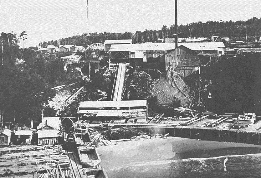
Headed by entrepreneur Dan Reese and mill boss John Craig, the MTC began clearing the bush, building a road, a wharf and breakwater in 1916. A sawmill was ordered from the Sumner Iron Works in the Pacific north-west. Convinced of the merits of importing American technology and milling on a grand scale, in 1921, Reese and Craig imported an American-built Lidgerwood log hauler, the largest and most sophisticated log hauler employed in New Zealand at the time. The main mill opened in September 1921, by which time the settlement was largely complete. By 1928, the operation included the huge mill and settlement, a railway-quality bush tramway, four towering timber viaducts, and had cut forest over an area of hundreds of hectares. Port Craig Sawmill and Settlement had a brief but stellar period of use, and by 1928 it had the largest output in the country.
Despite the massive outlay, the mill failed to make money. The Lidgerwood hauler broke down in 1926 and by 1928 the company was no longer able to function and the mill was closed. It revived briefly in 1930 but by the late 1930s the settlement had been largely demolished. Forest reclaimed much of area, and the tramway and viaducts slowly deteriorated.
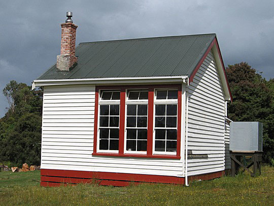
In 1999, the land around the sawmill site became part of the Fiordland National Park. The Department of Conservation (DOC) upgraded the tramway and restored the Port Craig School House and installed interpretation at Port Craig. Remains of the wharf, mill and township of Port Craig, are still evident within the National Park, as is evidence of logging activity. Machinery and structural remains are still in place at the beach and, on the plateau above, various relics are visible. Further to the south-west, on land that remains in SILNA ownership, are the remains of the tramway and the four viaducts.
Port Craig Sawmill and Settlement is a place of special heritage significance. Once the site of one of the most ambitious sawmilling enterprises in New Zealand history, it is now one of New Zealand's most important saw milling heritage sites, with a representative collection of relics and structures that remain intact from the time the place salvaged.
List Entry Information
Status
Listed
List Entry Status
Historic Place Category 1
Access
Able to Visit
List Number
9234
Date Entered
12th December 2013
Date of Effect
12th December 2013
City/District Council
Southland District
Region
Southland Region
Extent of List Entry
Extent includes part of the land described as Secs 1-3 Blk XII (RT SL88/206, 5362, SL88/210); Secs 5-8 Blk XII (RT SL88/212, SL88/204, SL88/213, SL88/207); Secs 11-12 Blk XII (Gravel Reserves Crown Land); Secs 1-7 Blk XIII (RTs SL88/164; SL88/209, SL88/214, SL88/179, SL88/180, SL88/208, SL88/163); Sec 9 Blk XIII (RT SL88/211); Sec 10 Blk XIII (RT SL88/160); Sec 13 Blk XIII (Education Reserve Crown Land); Sec 1 Blk XIV (RT SL82/191); all of the land described as Sec 2, 16 Blk XIV (NZ Gazette 1999 p. 3211); part of the land described as Crown Land Blk X Rowallan SD (NZ Gazette 1999 p. 3211); Road Reserve, All Rowallan SD, Southland Land District, where the tramway alignment runs and on which stand the four viaducts. Within Fiordland National Park the registration includes both the archaeological remains and extant features of the whole of that area related to the sawmilling operation. It incorporates the remains of the mill, settlement and wharf at Port Craig, including the school house, along with the tramway and branch lines and associated features. It also includes the evidence of timber cutting and retrieval, including log hauler sites, skid sites, drag lines and stumps. Outside Fiordland National Park, the registration includes the main tramway alignment and the four timber viaducts only. This registration includes chattels that contribute to the heritage significance of the place: saw milling remnants and related archaeological material associated with Port Craig Sawmill and Settlement within the boundary. A new complex was built in 2001 for the Hump Ridge Track, which is comprised of a number of buildings for accommodation, cooking and ablutions, plus boardwalk. These buildings are within the registration boundary but are not considered to have heritage significance.
Legal description
Secs 1-3 Blk XII (RT SL88/206, 5362, SL88/210); Secs 5-8 Blk XII (RT SL88/212, SL88/204, SL88/213, SL88/207); Secs 11-12 Blk XII (Gravel Reserves Crown Land); Secs 1-7 Blk XIII (RTs SL88/164; SL88/209, SL88/214, SL88/179, SL88/180, SL88/208, SL88/163); Sec 9 Blk XIII (RT SL88/211); Sec 10 Blk XIII (RT SL88/160); Sec 13 Blk XIII (Education Reserve Crown Land); Sec 1 Blk XIV (RT SL82/191); Sec 2, 16 Blk XIV (NZ Gazette 1999 p. 3211); Crown Land Blk X Rowallan SD (NZ Gazette 1999 p. 3211); Road Reserve, All Rowallan SD, Southland Land District.
Location Description
Port Craig is located some 50 kilometres west of Invercargill on the southern coast of the South Island at the western edge of Te Waewae Bay. Part of the South Coast Track follows the line of the main tramway of the Port Craig Sawmill. There is no street address associated with this property.
Why is this place significant?
Cultural Significance
Social Significance or Value During the period that Port Craig Sawmill and Settlement was largely forgotten and saw few visitors, the social significance of the structures was confined to those who had been associated with the enterprise in the 1920s; their numbers were of course diminishing. With the development of the viaducts by South Coast Track, and the Tuatapere community and re-emergence as tourist attractions, Department of Conservation accommodation at Port Craig School and the community’s development of the Hump Ridge track, the Sawmill and Settlement Site is now part of a network of places appreciated by visitors and locals alike. The social significance of Port Craig can now be considered high. As part of the Hump Track, Port Craig is now visited by many people and numbers are likely to grow in years to come. Perhaps the most telling example of the area's growing social significance is the role of the Viaducts Trust in raising funds and volunteering their time to save the viaducts. It is evidence of the importance of Port Craig Sawmill and Settlement and those great timber structures to the people of west Southland, and, Southland as a whole.
Historic Significance
Historical Significance or Value Port Craig Sawmill and Settlement has special historical significance as the site of a saw milling venture unsurpassed both in its scale and investment in New Zealand, and also pioneering in its harnessing of American technology not previously used in the country. At its peak, the milling operation was producing timber faster than any other mill and it represented the pinnacle of the indigenous milling industry. It has left behind a significant group of relics, which are testimony to the scale of the Port Craig Sawmill and Settlement operation. The tramway and viaducts are crucial elements in the mill’s operation system, opening up forests to the west of the mill. In the period before the advent of motorised vehicles, bush tramways were the only realistic way of moving timber from the bush to the mill. The tramway at Port Craig is a singular example of its type in New Zealand. The failure of Port Craig Sawmill and Settlement was a harbinger of times to come. The timber industry began a downturn in advance of the coming Depression. When Port Craig Sawmill and Settlement closed in 1928, it was not only a shock to the company, but many workers and their families were left at Bluff without a job or a roof over their heads. It was an early example of the forces that were soon to affect the world economy.
Physical Significance
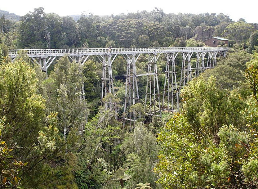
Aesthetic Significance or Value Port Craig Sawmill and Settlement is a place of very high natural beauty, with both first growth and regenerating forest softening or masking the impact that humans have had within this spectacular and isolated area. Where structures are intact or prominent, such as the viaducts and tramways, the wharf and the remnant buildings, they sit in easy harmony with the surrounding landscape. The viaducts themselves are dramatic and striking structures in their surroundings. As every year passes, it is becoming more difficult to see the extent of human impact on the landscape, particularly at the site of the former mill and settlement. Archaeological Significance or Value Port Craig Sawmill and Settlement has significant archaeological value. The timber mill itself is listed as NZ Archaeological Site C46/25 (timber mill). The area is a mixture of the ruins and remains of the former wharf, mill and township of Port Craig, remnants left behind by the scrappers sent in 1938 (when the sawmilling venture ended) that have since deteriorated, together with evidence of logging, and those structures that remain largely intact, including the main tramway, some branch lines, and the Port Craig School. Machinery and structural remains and relics can be found at the beach and on the plateau above. The area has the potential to reveal other features or items of interest from the milling operation and settlement through archaeological techniques. Technological Significance or Value The removal of many of Port Craig Sawmill and Settlement's structures and much of its machinery has robbed it of some of its technological value but much remains of great importance. The crowning glory of Port Craig Sawmill and Settlement, the group of four timber viaducts, is of outstanding technological value. The construction of the viaducts, in Australian hardwood, in a remote and difficult part of the country was achievement enough, but they went on to be used successfully for the purpose intended, and still stand (with some recent assistance) over 80 years later. The structures can tell us much about the construction of timber viaducts in the early decades of the 20th century. They offer four contrasting but similar examples of the now abandoned method of timber viaduct construction, and remain largely intact. The site provides evidence of the technologies associated with the operation of what was New Zealand’s largest sawmill at that time.
Why is this place Category 1 / Category 2?
Detail Of Assessed Criteria
(a) The extent to which the place reflects important or representative aspects of New Zealand history Port Craig Sawmill and Settlement can be considered the peak of the indigenous saw milling industry; the culmination of 100 years of one of New Zealand's most important early industries. The ideas imported by the Marlborough Timber Co. from the United States, the supersize mill and the fast efficient timber retrieval, had never been seen in New Zealand before and were not really tried again with indigenous sawmilling. Large scale milling was not attempted in this way until production of exotic timber began in the late 1930s. Furthermore, in the period after Port Craig Sawmill and Settlement closed, no bush tramway was built that came close to matching the quality and scale of the one built at Port Craig. (b) The association of the place with events, persons, or ideas of importance in New Zealand history The concepts of timber retrieval and milling pursued at Port Craig were, by New Zealand standards, innovative, even revolutionary for their time and displayed the vision of the Marlborough Timber Co.'s key personnel, John Craig and Dan Reese. Reese was a significant New Zealander, being both a successful sportsman who captained his country in cricket, and a dynamic and (largely) successful businessman. Ironically, he is best known for his great 'failure' - Port Craig. (e) The community association with, or public esteem for the place During the period that Port Craig Sawmill and Settlement was largely forgotten and saw few visitors, the social significance of the structures was confined to those who had been associated with the enterprise in the 1920s; their numbers were diminishing. The Port Craig Sawmill and Settlement was largely forgotten until the early 1990s, when the fame of the nearby viaducts and their precarious state, aroused considerable interest locally and nationally. The creation of the Port Craig Viaducts Trust, with its predominantly local membership, indicated the depth of connection with Port Craig and its future. Since then, the Trust, together with DOC and Venture Southland, has continued to respond to public support for the retention and conservation of Port Craig, the tramway and the associated viaducts. (f) The potential of the place for public education Port Craig Sawmill and Settlement offers much in the way of public education possibilities. Despite the loss of many of the mill-related features the area retains extensive remnants and relics from the milling operation, including the dramatic bush tramway and viaducts. The settlement includes the intact Port Craig School, which has considerable potential to inform the public in its current role as overnight accommodation for visitors. Public interest in the area has increased considerably since the 1990s. As part of the Hump Track, Port Craig is now visited by many people and numbers are likely to grow in years to come. (g) The technical accomplishment or value, or design of the place Port Craig Sawmill and Settlement is a place of special technical value, both for the remnants and structures at Port Craig and for the wider assemblage of heritage, including tramway and timber viaducts. The tramway demonstrates a very high technical accomplishment in the quality of the construction, with the cuttings, embankments, sleepers, water control, and, most of all, reflects the viaducts. The latter were a dramatic and necessary requirement for maintaining the tramway grade, and today survive as the greatest example of the grand vision of the Marlborough Timber Co. (j) The importance of identifying rare types of historic places The remaining structures and features at Port Craig are atypical of standard New Zealand indigenous saw milling from the nineteenth and early twentieth centuries and as such are rare survivors. The scale and modern technology used was unlike anything attempted before, so in this sense Port Craig Sawmill and Settlement can be regarded as unique. When technology of this nature was used again in New Zealand, roughly 20 years later, it was employed on exotic plantings. Secondly, of the remaining features, the viaducts are without parallel in New Zealand. No substantial timber viaducts remain intact in New Zealand, let alone four in one place. Thirdly, Port Craig contains the most complete remains of the large-scale milling operations in New Zealand. Unlike Port Craig other comparable examples do not retain at least some portion of their main features. (k) The extent to which the place forms part of a wider historical and cultural complex or historical and cultural landscape Port Craig Sawmill and Settlement as a place has value as part of a wider historical landscape. The milling operations extended to the west, beyond the Fiordland National Park and the Port Craig Sawmill and Settlement Site into SILNA land, which includes remnants of the bush tramway and the four impressive viaducts. Summary of Significance or Values Port Craig Sawmill and Settlement is a place of special heritage significance. The registration covers all the activities that formed the Port Craig operation (timber cutting, retrieval, milling and shipping) together with the construction of the various buildings and structures required to make the place function. No other timber industry site of a comparable size is so complete. It is a place that contains a striking mixture of the archaeological and the structural. The latter is best exemplified by the four viaducts that still stand in the regenerating forest. Together with the magnificent tramway, they demonstrate the vision, scale and ingenuity of the Marlborough Timber Company.
Why is this place significant?
Cultural Significance
Social Significance or Value During the period that Port Craig Sawmill and Settlement was largely forgotten and saw few visitors, the social significance of the structures was confined to those who had been associated with the enterprise in the 1920s; their numbers were of course diminishing. With the development of the viaducts by South Coast Track, and the Tuatapere community and re-emergence as tourist attractions, Department of Conservation accommodation at Port Craig School and the community’s development of the Hump Ridge track, the Sawmill and Settlement Site is now part of a network of places appreciated by visitors and locals alike. The social significance of Port Craig can now be considered high. As part of the Hump Track, Port Craig is now visited by many people and numbers are likely to grow in years to come. Perhaps the most telling example of the area's growing social significance is the role of the Viaducts Trust in raising funds and volunteering their time to save the viaducts. It is evidence of the importance of Port Craig Sawmill and Settlement and those great timber structures to the people of west Southland, and, Southland as a whole.
Historic Significance
Historical Significance or Value Port Craig Sawmill and Settlement has special historical significance as the site of a saw milling venture unsurpassed both in its scale and investment in New Zealand, and also pioneering in its harnessing of American technology not previously used in the country. At its peak, the milling operation was producing timber faster than any other mill and it represented the pinnacle of the indigenous milling industry. It has left behind a significant group of relics, which are testimony to the scale of the Port Craig Sawmill and Settlement operation. The tramway and viaducts are crucial elements in the mill’s operation system, opening up forests to the west of the mill. In the period before the advent of motorised vehicles, bush tramways were the only realistic way of moving timber from the bush to the mill. The tramway at Port Craig is a singular example of its type in New Zealand. The failure of Port Craig Sawmill and Settlement was a harbinger of times to come. The timber industry began a downturn in advance of the coming Depression. When Port Craig Sawmill and Settlement closed in 1928, it was not only a shock to the company, but many workers and their families were left at Bluff without a job or a roof over their heads. It was an early example of the forces that were soon to affect the world economy.
Physical Significance
Aesthetic Significance or Value Port Craig Sawmill and Settlement is a place of very high natural beauty, with both first growth and regenerating forest softening or masking the impact that humans have had within this spectacular and isolated area. Where structures are intact or prominent, such as the viaducts and tramways, the wharf and the remnant buildings, they sit in easy harmony with the surrounding landscape. The viaducts themselves are dramatic and striking structures in their surroundings. As every year passes, it is becoming more difficult to see the extent of human impact on the landscape, particularly at the site of the former mill and settlement. Archaeological Significance or Value Port Craig Sawmill and Settlement has significant archaeological value. The timber mill itself is listed as NZ Archaeological Site C46/25 (timber mill). The area is a mixture of the ruins and remains of the former wharf, mill and township of Port Craig, remnants left behind by the scrappers sent in 1938 (when the sawmilling venture ended) that have since deteriorated, together with evidence of logging, and those structures that remain largely intact, including the main tramway, some branch lines, and the Port Craig School. Machinery and structural remains and relics can be found at the beach and on the plateau above. The area has the potential to reveal other features or items of interest from the milling operation and settlement through archaeological techniques. Technological Significance or Value The removal of many of Port Craig Sawmill and Settlement's structures and much of its machinery has robbed it of some of its technological value but much remains of great importance. The crowning glory of Port Craig Sawmill and Settlement, the group of four timber viaducts, is of outstanding technological value. The construction of the viaducts, in Australian hardwood, in a remote and difficult part of the country was achievement enough, but they went on to be used successfully for the purpose intended, and still stand (with some recent assistance) over 80 years later. The structures can tell us much about the construction of timber viaducts in the early decades of the 20th century. They offer four contrasting but similar examples of the now abandoned method of timber viaduct construction, and remain largely intact. The site provides evidence of the technologies associated with the operation of what was New Zealand’s largest sawmill at that time.
Why is this place Category 1 / Category 2?
Detail Of Assessed Criteria
(a) The extent to which the place reflects important or representative aspects of New Zealand history Port Craig Sawmill and Settlement can be considered the peak of the indigenous saw milling industry; the culmination of 100 years of one of New Zealand's most important early industries. The ideas imported by the Marlborough Timber Co. from the United States, the supersize mill and the fast efficient timber retrieval, had never been seen in New Zealand before and were not really tried again with indigenous sawmilling. Large scale milling was not attempted in this way until production of exotic timber began in the late 1930s. Furthermore, in the period after Port Craig Sawmill and Settlement closed, no bush tramway was built that came close to matching the quality and scale of the one built at Port Craig. (b) The association of the place with events, persons, or ideas of importance in New Zealand history The concepts of timber retrieval and milling pursued at Port Craig were, by New Zealand standards, innovative, even revolutionary for their time and displayed the vision of the Marlborough Timber Co.'s key personnel, John Craig and Dan Reese. Reese was a significant New Zealander, being both a successful sportsman who captained his country in cricket, and a dynamic and (largely) successful businessman. Ironically, he is best known for his great 'failure' - Port Craig. (e) The community association with, or public esteem for the place During the period that Port Craig Sawmill and Settlement was largely forgotten and saw few visitors, the social significance of the structures was confined to those who had been associated with the enterprise in the 1920s; their numbers were diminishing. The Port Craig Sawmill and Settlement was largely forgotten until the early 1990s, when the fame of the nearby viaducts and their precarious state, aroused considerable interest locally and nationally. The creation of the Port Craig Viaducts Trust, with its predominantly local membership, indicated the depth of connection with Port Craig and its future. Since then, the Trust, together with DOC and Venture Southland, has continued to respond to public support for the retention and conservation of Port Craig, the tramway and the associated viaducts. (f) The potential of the place for public education Port Craig Sawmill and Settlement offers much in the way of public education possibilities. Despite the loss of many of the mill-related features the area retains extensive remnants and relics from the milling operation, including the dramatic bush tramway and viaducts. The settlement includes the intact Port Craig School, which has considerable potential to inform the public in its current role as overnight accommodation for visitors. Public interest in the area has increased considerably since the 1990s. As part of the Hump Track, Port Craig is now visited by many people and numbers are likely to grow in years to come. (g) The technical accomplishment or value, or design of the place Port Craig Sawmill and Settlement is a place of special technical value, both for the remnants and structures at Port Craig and for the wider assemblage of heritage, including tramway and timber viaducts. The tramway demonstrates a very high technical accomplishment in the quality of the construction, with the cuttings, embankments, sleepers, water control, and, most of all, reflects the viaducts. The latter were a dramatic and necessary requirement for maintaining the tramway grade, and today survive as the greatest example of the grand vision of the Marlborough Timber Co. (j) The importance of identifying rare types of historic places The remaining structures and features at Port Craig are atypical of standard New Zealand indigenous saw milling from the nineteenth and early twentieth centuries and as such are rare survivors. The scale and modern technology used was unlike anything attempted before, so in this sense Port Craig Sawmill and Settlement can be regarded as unique. When technology of this nature was used again in New Zealand, roughly 20 years later, it was employed on exotic plantings. Secondly, of the remaining features, the viaducts are without parallel in New Zealand. No substantial timber viaducts remain intact in New Zealand, let alone four in one place. Thirdly, Port Craig contains the most complete remains of the large-scale milling operations in New Zealand. Unlike Port Craig other comparable examples do not retain at least some portion of their main features. (k) The extent to which the place forms part of a wider historical and cultural complex or historical and cultural landscape Port Craig Sawmill and Settlement as a place has value as part of a wider historical landscape. The milling operations extended to the west, beyond the Fiordland National Park and the Port Craig Sawmill and Settlement Site into SILNA land, which includes remnants of the bush tramway and the four impressive viaducts. Summary of Significance or Values Port Craig Sawmill and Settlement is a place of special heritage significance. The registration covers all the activities that formed the Port Craig operation (timber cutting, retrieval, milling and shipping) together with the construction of the various buildings and structures required to make the place function. No other timber industry site of a comparable size is so complete. It is a place that contains a striking mixture of the archaeological and the structural. The latter is best exemplified by the four viaducts that still stand in the regenerating forest. Together with the magnificent tramway, they demonstrate the vision, scale and ingenuity of the Marlborough Timber Company.
Construction Professional
Name
Chester Construction Co
Type
Builder
Biography
Little is known of the Chester Construction Company other than that it was possibly a Canadian company, and that the construction of the Percy Burn Viaduct eventually resulted in its bankruptcy.
Name
P. Graham and Son
Type
Builder
Biography
P. Graham and Son of Christchurch.
Name
Kane, Peter
Type
Builder
Biography
No biography is currently available for this construction professional
Construction Details
Start Year
1916
Type
Original Construction
Description
Work begins on clearing the bush and building a storage shed and wharf
Start Year
1917
Type
Additional building added to site
Description
Wharf finished; One of two Opouri Mills is shipped south to cut timber for the big new mill. Wharf, breakwater, huts and roads completed
Start Year
1918
Type
Addition
Description
Work on tramway begins
Start Year
1918
Type
Addition
Description
22 Sept Big mill opens
Start Year
1922
Type
Addition
Description
The 90 tonne Lidgerwood Overhead Logging Plant arrives. It remains in use for four years
Start Year
1923
Type
Addition
Description
Peter (Sand Hill Point) Burn viaduct built by Jim Kane
Start Year
1924
Finish Year
1925
Type
Addition
Description
Percy Burn viaduct built by Chester Construction Co. Ltd
Start Year
1925
Finish Year
1926
Type
Addition
Description
Lidgerwood aerial hauler failed and abandoned between Percy Burn and Edwin Burn; replaced by four small haulers
Start Year
1926
Type
Addition
Description
Lidgerwood aerial hauler failed and abandoned between Percy Burn and Edwin Burn; replaced by four small haulers
Start Year
1928
Type
Other
Description
October, Port Craig is closed and machinery, buildings and infrastructure transferred to Holdings Ltd
Start Year
1938
Finish Year
1939
Type
Modification
Description
Salvagers remove most items of value from the site
Start Year
1979
Type
Restoration
Description
Decks of viaducts resurfaced by New Zealand Deerstalkers Association.
Start Year
1980
startYearCirca
Type
Restoration
Description
First attempt at fixing pier ends on Percy Burn
Start Year
1991
Type
Restoration
Description
Royal New Zealand Engineers make rudimentary repairs to Percy Burn
Start Year
1994
Type
Restoration
Description
Stabilisation of Percy Burn undertaken by Armstrong Rigging of Wellington
Start Year
1995
startYearCirca
Type
Restoration
Description
Port Craig School House restored
Start Year
1999
Type
Restoration
Description
Stabilisation of Sand Hill, Francis and Edwin Burn viaducts, plus more work on Percy Burn, undertaken by Breen Construction of Wanaka
Start Year
2013
Type
Other
Description
Percy Burn Viaduct closed. Bypass track constructed.
Construction Materials
Timber, iron, concrete, brick
Port Craig was the name given to the mill and settlement that was the centrepiece of an ambitious and technologically advanced logging and milling operation by the Marlborough Timber Company between 1916 and the late 1920s. Early History of Waitutu The Waitutu area was sporadically visited by Maori, attracted by the rich kai moana and the birdlife inland. Archaeological sites along the coast, some in and around Sand Hill Point, reveal the use Maori made of the area. Two adzes dating from prior to 1769 were reportedly found during an excavation in 1940 of the foundations of one of the mill houses. There were tracks that provided access to places west such as the Wairaurahiri River and beyond. A portion of the Waitutu native forest was granted to named Maori under the South Island Landless Natives Act 1906 (SILNA). SILNA provided for the allocation of about 57,000 hectares of land, throughout the South Island, to more than 4000 named Maori who were identified as having insufficient land to support them. The major tracts were in the Rowallan Alton and West Rowallan blocks (western Southland). The Waitangi Tribunal records that ‘SILNA was an attempt to address the plight of those Ngai Tahu (Kai Tahu) who had been rendered landless or nearly so by the Crown’s failure to prevent that from occurring as a result of its various land purchases in the South Island in the 1840s and 1850s.The SILNA land was granted as an economic resource to named individuals and their heirs and assigns forever. It was and is ‘absolutely inalienable’. Ecologist and forester Nora Devoe says that when they were granted the ‘SILNA lands were among the least valuable lands in New Zealand.’ Devoe writes that the Crown intended the lands to be farmed, but that the lands were mostly unsuitable for farming and most SILNA land (including the Rowallan Blocks) in 2008 remains unoccupied. Ultimately the SILNA land grants led to further grievances, recognised by the Waitangi Tribunal in their 1999 Ngai Tahu report. Around the time the SILNA lands were being granted, the forestry industry was vital to New Zealand’s development. Environmental historian Graeme Wynn writes that nineteenth century New Zealand as a ‘wooden world’ – citizens’ ‘very existence rested upon the forest’s bounty.’ Without the bush New Zealand ‘could not have developed as it did.’ Millers were, Wynn writes, ‘the prime movers of change,’ and mills left their mark on the landscape. Two years after the Act was passed, the government granted cutting rights over the SILNA land in what became known as the Port Craig area. Research has not clarified the relationship between SILNA landowners and the parties that obtained cutting rights. One unreferenced source indicates that logging of the SILNA land did provide some income to owners from the timber. Marlborough Timber Company The cutting rights to the SILNA land in Port Craig were granted to the Marlborough Timber Company, which was one of the many business concerns of Dan Reese (1879-1958) and his brother Tom, who founded the building firm of Reese Brothers in 1907. The MTC was the brothers’ most profitable business. It had begun operations in the Opouri Valley in Marlborough in 1908. By 1914 the MTC was on the lookout for new stands to mill. It was also interested in expanding the capabilities of the New Zealand industry by introducing American and Canadian sawmilling plant and logging equipment into the New Zealand industry. To do this, MTC needed large forests with high yielding trees to sustain the scale and efficiency of the new technology. The man who convinced the company directors of the merits of this departure from existing sawmilling techniques was John Craig, the manager of the Marlborough operation and a successful West Coast miller. Craig was sent to America in 1915 to investigate new milling techniques. During a two week reconnaissance in 1916, Craig convinced Dan Reese of the viability of a site west of Tuatapere at Te Waewae Bay in Southland. When the government granted cutting rights over the SILNA land, MTC took up the option on 1600 hectares of coastal forest at Mussel Beach, the nearest safe site in the area to build a wharf. Establishing Port Craig Sawmill and Settlement Port Craig Sawmill was a pioneering venture. The scale and modern technology used at Port Craig was unlike anything attempted before. When technology of this nature was used again in New Zealand, roughly 20 years later, it was employed on exotic plantings. It was not until the 1950s that comparable technology was introduced in two State-run mills in the 1950s - the Conical Hills State sawmill in Southland and the Waipa State sawmill used similar technology. Almost immediately, work began on clearing the bush and building an access road and storage shed. Two months after the directors' visit, timber arrived to build the wharf. By early 1917 the wharf was finished and a 'travelling' steam crane had been delivered for use on the wharf and for the construction of a breakwater on exposed Mussel Bay. Planning was underway for the sawmill and an aerial cableway. Plant and machinery were ordered from the Sumner Iron Works in Everett, Washington State, USA. The MTC shipped one of its two Opouri mills south to cut timber for the construction of the big new mill. A breakwater, workers’ huts and rudimentary roads were completed and the first cuttings for the tramway were underway. From 1917 on the company built a store, cookhouse, social hall, billiard room, library and school, as well as many houses and huts. The mill manager's house, the finest in the settlement, was built on the north-west edge of the plateau. The first school house was erected in 1921, on the shore of the bay itself, hemmed in by stacks of timber as spare room became scarce near the wharf. This unsuitable arrangement only ended with the building of the second Port Craig School building on the plateau above. This building was designed by the Southland Education Board and built by the board's own staff, Development was affected by tragedy, which struck the company in November 1917, just as the re-erection of the pilot mill was finished. John Craig, the driving force behind the development, drowned, along with launchman Fred Parry. The site at Mussel Beach, was renamed Port Craig in his memory. The impact of Craig’s death was significant. Work went on, but without the zeal and impetus that Craig brought to proceedings. On top of that, John Craig’s brother James was killed after an explosion during the forming of a tramline cutting in October 1918. Despite these tragedies, the mill, which was built by MTC director and Christchurch builder Peter Graham, opened with much fanfare, on 22 September 1921. Construction of the mill itself was overseen by representatives of the Sumner Iron Works, Amos Markey and Dan Wilder. Tramway and branch lines While work on the mill, wharf and town was progressed, the other key feature, the tramway, began to push south-west away from Port Craig. The tramway was vital as a means of extracting timber efficiently enough to feed the mill. Work on the tramway began in 1917 and the route left Port Craig in a south-west direction, roughly parallel to the shore but several hundred metres inland. At Sand Hill Point it turned west and continued its parallel to the coast. When work ended, the main tramway was 14.6 kilometres long, with a further 9.8 kilometres of branch line. The main tramway was built to a very high standard on a 3' 6’ gauge (NZ Railways’ standard). As with any tramway, maintaining the grade was essential. Most of the ground it was laid on sloped uphill from the beach. Some cuttings were deep but most were not substantial. There were some minor bench cuts and, along with the four deep rivers, there were other stream crossings required too. The majority of the workers, who had only hand tools, horses and explosives to build the tramway, were Irish immigrants. Maintaining the grade – building the viaducts While the land being milled by the company was not steep, it was cut by numerous water courses. The four biggest water courses were deep incisions and formidable obstacles. The first, the Peter Burn, was encountered approximately seven kilometres from Port Craig. Not enough historical information exists to establish the exact sequence of viaduct construction. It is almost certain that work on Percy Burn began while Peter Burn (more commonly known as Sand Hill Point, or simply Sand Hill) was also under construction. Edwin Burn and Francis Burn were further to the west and would not have been required immediately. However, Bird states that tramway construction ran ahead of the building of those two viaducts so that timber could be extracted to feed the mill. The largest and most celebrated of the four viaducts, Percy Burn, was built by the Chester Construction Co. of Invercargill. Work on Percy Burn took over a year and it was completed in 1925. James Bremer, a sawmill hand at Port Craig in 1925, recalled how the viaducts were ‘built in an efficient and tradesman-like way with minimum delay’. However, the work was obviously challenging and the difficulties were reflected in the final cost of the job. Chester’s contract price was about £6,000, but it fell short by some £500. When Chester left the settlement at the end of the contract, he must have known it had reduced his business to bankruptcy. Jim Kane built Sand Hill, Edwin Burn and Francis Burn Viaducts. Again, the exact date of their construction is not known, although they are unlikely to have been completed before 1926. As with Sand Hill, no specifics on their construction have survived. Each viaduct’s design exhibited a response to the challenges each site required. At Edwin Burn, for instance, a long middle span was required to avoid building concrete foundations in the river. In that case, three horizontal beams (as opposed to the two used on the others) were used to help carry the deck and its load. In general, the difficulties posed by the viaducts were partly a result of their isolation and awkward sites, with steep sided rivers, heavy bush (that had to be cleared), cold and inclement weather, sand flies and, of course, the technological limitations of the day. Timber extraction The branch lines allowed for a wider field of extraction, particularly after the arrival, in 1921, of the American-built Lidgerwood log hauler, (the Lidgerwood Overhead Logging Plant or ‘skyline yarder’ or 'cableway skidder') the largest and most sophisticated log hauler employed in New Zealand. The Lidgerwood Machinery Company (LMC) became famous for its winches, scrapers and cranes. The Lidgerwood hauler could sit in one place and haul logs from a distance of 800 metres via a complex, cable-operated overhead system. By moving its main spar, it could operate on a 360 degree spectrum. It could be spectacularly efficient when bringing in multiple logs and could load bogies with ease. For several decades after extraction, it was possible to see the Lidgerwood’s impact from the air, with the lines of timber extraction resembling spokes on a bicycle wheel. Port Craig: the town Throughout the 1920s the industrial plant and settlement continued to grow and develop. Apart from the main mill, a huge ramp was built to shift cut timber down from the mill to the beach (plus storage skids for the timber). A third boiler and funnel was added to the mill in 1926. Later, in 1928, an aerial loader was built to get the timber into the ships more efficiently, especially in poor weather. Prior to this loading was done from the wharf to lighters (barges) and then from the lighters to the ships, moored out beyond the breakwater. By the late 1920s, Port Craig Sawmill and Settlement was comprised of a range of structures, directly mill-related or core township buildings and accommodation. Among the significant structures on the beach were the timber storage platforms (on the wharf and beach), breakwater and wharf, and first school. The timber conveyor linked the mill with the beach. On the plateau above were the old and new mills, bake house, cookshop, billiard room, school, store, library, the bush boss's house, the manager's house, carpenter's shop, various married quarters, single men's huts. There were also various tramways, walking tracks and a road. The beginning of the end The massive investment in Port Craig’s infrastructure hardly repaid its backers. Despite a capital injection in 1927, the mill still struggled to make money. In 1928, after operating for five years, the Lidgerwood broke down a short distance west of the Percy Burn viaduct. It was decided not to repair it and four smaller haulers were purchased instead to keep the work going. By October 1928, however, the operation had become unsustainable and the Company Directors were forced to close the entire operation immediately. With minimal notice, mill workers and their families were put on ships and taken to Bluff. A skeletal staff was kept on to maintain the equipment, by Holdings Ltd., a company set up by Sims Cooper to take over the liquidated MTC assets. The mill reopened briefly in January 1930, a response to the Government lifting export restrictions on indigenous timber but shut down permanently in November 1930. Nevertheless, there were still hopes that the place would be revived. Holdings Ltd stayed on through the Depression. In 1937, Bert Craig, son of the mill’s founder John Craig, inspected the mill and tramway. He found them in a markedly deteriorated condition. To get any sort of return on their investment, Holdings sold the mill and equipment to salvagers, who took away anything of value and demolished the much of the remainder. The wharf was retained but is understood to have been demolished at a later date by the New Zealand Army. A house and the Port Craig School House, which was the property of the Education Department, were also retained. Salvagers removed most of the rail, switches and points of the tramway, but the formation and sleepers were left intact. Decay and rediscovery Despite suggestions from some that Port Craig Sawmill and Settlement might rise again, there was no return to sawmilling. Thereafter, and for many decades, the only visitors to the area were trampers and hunters. The School House was passed to the New Zealand Forest Service in 1960 or 1961, and was used as overnight accommodation. The building became the responsibility of the Department of Conservation after its formation in 1987. The viaducts had become a serious maintenance issue by the 1970s. The decks of the viaducts were in such a precarious condition that some had to resort to crossing them on hands and knees. Percy Burn was the subject of multiple attempts to burn it down. On one occasion, one pier leg was nearly burnt through, while another attempt on the viaduct’s deck was allegedly undertaken by a disgruntled Forest Service employee, trying to stop anyone from gaining access to the forest beyond the viaduct. The critical state of the viaducts, particularly Percy Burn, became apparent at the same time that the community was waking up to their heritage value and tourism potential. It was not until the 1980s and the awakening of a wider interest in industrial heritage that the viaducts came to be seen in a new light. Oral histories conducted by timber historian Paul Mahoney in the 1980s captured the memories of men who worked at Port Craig Sawmill and Settlement. In 1990, a report was compiled by the New Zealand Historic Places Trust on the history and engineering of the viaducts and, as part of sesquicentennial celebrations, the Institute of Professional Engineers (IPENZ) acknowledged the significance of Percy Burn Viaduct. Rejuvenation The New Zealand Historic Places Trust report had an immediate impact. In 1991, DOC arranged for Royal New Zealand Army engineers to do some basic remedial work on Percy Burn. Despite the army’s work, it and the other viaducts still faced collapse. Alarmed at the prospect of losing the viaducts, western Southlanders decided to try to save them. A public meeting at Tuatapere on 28 April 1993 led to the formation of the Port Craig Viaducts Trust. The immediate aim of the Viaducts Trust was to stabilise Percy Burn, the largest and most celebrated of the four viaducts. With the stabilisation work completed, Percy Burn was reopened in a ceremony attended by 170 people. The next phase of the restoration was the stabilisation of the remaining viaducts. Tenders were initially called in November 1997 and Breen Construction of Wanaka were the preferred tenderers. Sand Hill Point was the first viaduct to receive attention, with only one pier requiring new timber. The most significant issue turned out to be the condition of Edwin Burn which was on the point of collapse. The repairs required were extensive. At Francis Burn, the piers were also in poor condition. At each viaduct, excluding Percy Burn, handrails were added to the upstream side of the decks. All the viaducts received preservation treatment and the entire cost of the project was $227,252. A conservation plan for the viaducts was completed in 2008. A sustainable use The obvious attractions of the area’s forests and mountains, and its Maori and European history, spurred a group of locals to form a group dedicated to turning the forest and its landmark to the north, Hump Ridge, into a three-day tramping round trip. In 1999, 46,000 hectares of Waitutu Forest (including the old Port Craig settlement) was added to Fiordland National Park. Along the way, the route passes over three of the four viaducts. The portion from Edwin Burn to Port Craig was the former tramway and already part of the South Coast Track. When it opened in November 2001, it was New Zealand’s first (and still the only) privately operated walk on public land. DOC undertook work at Port Craig. It put major features on display and created a small track system between them. Interpretation signs and panels were installed over the 2003-04 summer. The work on the site began much earlier though. Removal of vegetation mound of bricks first began at the time of a 1996 archaeological survey. Clearance took place around the manager's house, the Lidgerwood frame, the old mill boiler, the baker's oven, and the remains of the sorting tables. The wharf crane was excavated from the beach. In 2004 work on the conservation of the various brick structures (baker's oven, old mill boiler, and the chimneys at Daly's (mill manager's) house) was undertaken. The rock wagons, previously in a slip prone area, were moved near the breakwater in September 2004. The Lidgerwood hauler frame was extracted from the earth and place on piles about 2005 or 2006. During its operation Port Craig sawmill was the most technologically advanced and most productive mill in New Zealand. Today it is an archaeological site - the country's most complete sawmilling complex featuring all stages and aspects of the timber industry. In 2012 Port Craig Sawmill and Settlement Site remains a historic attraction on the South Coast Walk in Fiordland, a rare survivor of the indigenous timber industry.
Port Craig was the name given to the mill and settlement that was the centrepiece of an ambitious and technologically advanced logging and milling operation by the Marlborough Timber Company between 1916 and the late 1920s. Early History of Waitutu The Waitutu area was sporadically visited by Maori, attracted by the rich kai moana and the birdlife inland. Archaeological sites along the coast, some in and around Sand Hill Point, reveal the use Maori made of the area. Two adzes dating from prior to 1769 were reportedly found during an excavation in 1940 of the foundations of one of the mill houses. There were tracks that provided access to places west such as the Wairaurahiri River and beyond. A portion of the Waitutu native forest was granted to named Maori under the South Island Landless Natives Act 1906 (SILNA). SILNA provided for the allocation of about 57,000 hectares of land, throughout the South Island, to more than 4000 named Maori who were identified as having insufficient land to support them. The major tracts were in the Rowallan Alton and West Rowallan blocks (western Southland). The Waitangi Tribunal records that ‘SILNA was an attempt to address the plight of those Ngai Tahu (Kai Tahu) who had been rendered landless or nearly so by the Crown’s failure to prevent that from occurring as a result of its various land purchases in the South Island in the 1840s and 1850s.The SILNA land was granted as an economic resource to named individuals and their heirs and assigns forever. It was and is ‘absolutely inalienable’. Ecologist and forester Nora Devoe says that when they were granted the ‘SILNA lands were among the least valuable lands in New Zealand.’ Devoe writes that the Crown intended the lands to be farmed, but that the lands were mostly unsuitable for farming and most SILNA land (including the Rowallan Blocks) in 2008 remains unoccupied. Ultimately the SILNA land grants led to further grievances, recognised by the Waitangi Tribunal in their 1999 Ngai Tahu report. Around the time the SILNA lands were being granted, the forestry industry was vital to New Zealand’s development. Environmental historian Graeme Wynn writes that nineteenth century New Zealand as a ‘wooden world’ – citizens’ ‘very existence rested upon the forest’s bounty.’ Without the bush New Zealand ‘could not have developed as it did.’ Millers were, Wynn writes, ‘the prime movers of change,’ and mills left their mark on the landscape. Two years after the Act was passed, the government granted cutting rights over the SILNA land in what became known as the Port Craig area. Research has not clarified the relationship between SILNA landowners and the parties that obtained cutting rights. One unreferenced source indicates that logging of the SILNA land did provide some income to owners from the timber. Marlborough Timber Company The cutting rights to the SILNA land in Port Craig were granted to the Marlborough Timber Company, which was one of the many business concerns of Dan Reese (1879-1958) and his brother Tom, who founded the building firm of Reese Brothers in 1907. The MTC was the brothers’ most profitable business. It had begun operations in the Opouri Valley in Marlborough in 1908. By 1914 the MTC was on the lookout for new stands to mill. It was also interested in expanding the capabilities of the New Zealand industry by introducing American and Canadian sawmilling plant and logging equipment into the New Zealand industry. To do this, MTC needed large forests with high yielding trees to sustain the scale and efficiency of the new technology. The man who convinced the company directors of the merits of this departure from existing sawmilling techniques was John Craig, the manager of the Marlborough operation and a successful West Coast miller. Craig was sent to America in 1915 to investigate new milling techniques. During a two week reconnaissance in 1916, Craig convinced Dan Reese of the viability of a site west of Tuatapere at Te Waewae Bay in Southland. When the government granted cutting rights over the SILNA land, MTC took up the option on 1600 hectares of coastal forest at Mussel Beach, the nearest safe site in the area to build a wharf. Establishing Port Craig Sawmill and Settlement Port Craig Sawmill was a pioneering venture. The scale and modern technology used at Port Craig was unlike anything attempted before. When technology of this nature was used again in New Zealand, roughly 20 years later, it was employed on exotic plantings. It was not until the 1950s that comparable technology was introduced in two State-run mills in the 1950s - the Conical Hills State sawmill in Southland and the Waipa State sawmill used similar technology. Almost immediately, work began on clearing the bush and building an access road and storage shed. Two months after the directors' visit, timber arrived to build the wharf. By early 1917 the wharf was finished and a 'travelling' steam crane had been delivered for use on the wharf and for the construction of a breakwater on exposed Mussel Bay. Planning was underway for the sawmill and an aerial cableway. Plant and machinery were ordered from the Sumner Iron Works in Everett, Washington State, USA. The MTC shipped one of its two Opouri mills south to cut timber for the construction of the big new mill. A breakwater, workers’ huts and rudimentary roads were completed and the first cuttings for the tramway were underway. From 1917 on the company built a store, cookhouse, social hall, billiard room, library and school, as well as many houses and huts. The mill manager's house, the finest in the settlement, was built on the north-west edge of the plateau. The first school house was erected in 1921, on the shore of the bay itself, hemmed in by stacks of timber as spare room became scarce near the wharf. This unsuitable arrangement only ended with the building of the second Port Craig School building on the plateau above. This building was designed by the Southland Education Board and built by the board's own staff, Development was affected by tragedy, which struck the company in November 1917, just as the re-erection of the pilot mill was finished. John Craig, the driving force behind the development, drowned, along with launchman Fred Parry. The site at Mussel Beach, was renamed Port Craig in his memory. The impact of Craig’s death was significant. Work went on, but without the zeal and impetus that Craig brought to proceedings. On top of that, John Craig’s brother James was killed after an explosion during the forming of a tramline cutting in October 1918. Despite these tragedies, the mill, which was built by MTC director and Christchurch builder Peter Graham, opened with much fanfare, on 22 September 1921. Construction of the mill itself was overseen by representatives of the Sumner Iron Works, Amos Markey and Dan Wilder. Tramway and branch lines While work on the mill, wharf and town was progressed, the other key feature, the tramway, began to push south-west away from Port Craig. The tramway was vital as a means of extracting timber efficiently enough to feed the mill. Work on the tramway began in 1917 and the route left Port Craig in a south-west direction, roughly parallel to the shore but several hundred metres inland. At Sand Hill Point it turned west and continued its parallel to the coast. When work ended, the main tramway was 14.6 kilometres long, with a further 9.8 kilometres of branch line. The main tramway was built to a very high standard on a 3' 6’ gauge (NZ Railways’ standard). As with any tramway, maintaining the grade was essential. Most of the ground it was laid on sloped uphill from the beach. Some cuttings were deep but most were not substantial. There were some minor bench cuts and, along with the four deep rivers, there were other stream crossings required too. The majority of the workers, who had only hand tools, horses and explosives to build the tramway, were Irish immigrants. Maintaining the grade – building the viaducts While the land being milled by the company was not steep, it was cut by numerous water courses. The four biggest water courses were deep incisions and formidable obstacles. The first, the Peter Burn, was encountered approximately seven kilometres from Port Craig. Not enough historical information exists to establish the exact sequence of viaduct construction. It is almost certain that work on Percy Burn began while Peter Burn (more commonly known as Sand Hill Point, or simply Sand Hill) was also under construction. Edwin Burn and Francis Burn were further to the west and would not have been required immediately. However, Bird states that tramway construction ran ahead of the building of those two viaducts so that timber could be extracted to feed the mill. The largest and most celebrated of the four viaducts, Percy Burn, was built by the Chester Construction Co. of Invercargill. Work on Percy Burn took over a year and it was completed in 1925. James Bremer, a sawmill hand at Port Craig in 1925, recalled how the viaducts were ‘built in an efficient and tradesman-like way with minimum delay’. However, the work was obviously challenging and the difficulties were reflected in the final cost of the job. Chester’s contract price was about £6,000, but it fell short by some £500. When Chester left the settlement at the end of the contract, he must have known it had reduced his business to bankruptcy. Jim Kane built Sand Hill, Edwin Burn and Francis Burn Viaducts. Again, the exact date of their construction is not known, although they are unlikely to have been completed before 1926. As with Sand Hill, no specifics on their construction have survived. Each viaduct’s design exhibited a response to the challenges each site required. At Edwin Burn, for instance, a long middle span was required to avoid building concrete foundations in the river. In that case, three horizontal beams (as opposed to the two used on the others) were used to help carry the deck and its load. In general, the difficulties posed by the viaducts were partly a result of their isolation and awkward sites, with steep sided rivers, heavy bush (that had to be cleared), cold and inclement weather, sand flies and, of course, the technological limitations of the day. Timber extraction The branch lines allowed for a wider field of extraction, particularly after the arrival, in 1921, of the American-built Lidgerwood log hauler, (the Lidgerwood Overhead Logging Plant or ‘skyline yarder’ or 'cableway skidder') the largest and most sophisticated log hauler employed in New Zealand. The Lidgerwood Machinery Company (LMC) became famous for its winches, scrapers and cranes. The Lidgerwood hauler could sit in one place and haul logs from a distance of 800 metres via a complex, cable-operated overhead system. By moving its main spar, it could operate on a 360 degree spectrum. It could be spectacularly efficient when bringing in multiple logs and could load bogies with ease. For several decades after extraction, it was possible to see the Lidgerwood’s impact from the air, with the lines of timber extraction resembling spokes on a bicycle wheel. Port Craig: the town Throughout the 1920s the industrial plant and settlement continued to grow and develop. Apart from the main mill, a huge ramp was built to shift cut timber down from the mill to the beach (plus storage skids for the timber). A third boiler and funnel was added to the mill in 1926. Later, in 1928, an aerial loader was built to get the timber into the ships more efficiently, especially in poor weather. Prior to this loading was done from the wharf to lighters (barges) and then from the lighters to the ships, moored out beyond the breakwater. By the late 1920s, Port Craig Sawmill and Settlement was comprised of a range of structures, directly mill-related or core township buildings and accommodation. Among the significant structures on the beach were the timber storage platforms (on the wharf and beach), breakwater and wharf, and first school. The timber conveyor linked the mill with the beach. On the plateau above were the old and new mills, bake house, cookshop, billiard room, school, store, library, the bush boss's house, the manager's house, carpenter's shop, various married quarters, single men's huts. There were also various tramways, walking tracks and a road. The beginning of the end The massive investment in Port Craig’s infrastructure hardly repaid its backers. Despite a capital injection in 1927, the mill still struggled to make money. In 1928, after operating for five years, the Lidgerwood broke down a short distance west of the Percy Burn viaduct. It was decided not to repair it and four smaller haulers were purchased instead to keep the work going. By October 1928, however, the operation had become unsustainable and the Company Directors were forced to close the entire operation immediately. With minimal notice, mill workers and their families were put on ships and taken to Bluff. A skeletal staff was kept on to maintain the equipment, by Holdings Ltd., a company set up by Sims Cooper to take over the liquidated MTC assets. The mill reopened briefly in January 1930, a response to the Government lifting export restrictions on indigenous timber but shut down permanently in November 1930. Nevertheless, there were still hopes that the place would be revived. Holdings Ltd stayed on through the Depression. In 1937, Bert Craig, son of the mill’s founder John Craig, inspected the mill and tramway. He found them in a markedly deteriorated condition. To get any sort of return on their investment, Holdings sold the mill and equipment to salvagers, who took away anything of value and demolished the much of the remainder. The wharf was retained but is understood to have been demolished at a later date by the New Zealand Army. A house and the Port Craig School House, which was the property of the Education Department, were also retained. Salvagers removed most of the rail, switches and points of the tramway, but the formation and sleepers were left intact. Decay and rediscovery Despite suggestions from some that Port Craig Sawmill and Settlement might rise again, there was no return to sawmilling. Thereafter, and for many decades, the only visitors to the area were trampers and hunters. The School House was passed to the New Zealand Forest Service in 1960 or 1961, and was used as overnight accommodation. The building became the responsibility of the Department of Conservation after its formation in 1987. The viaducts had become a serious maintenance issue by the 1970s. The decks of the viaducts were in such a precarious condition that some had to resort to crossing them on hands and knees. Percy Burn was the subject of multiple attempts to burn it down. On one occasion, one pier leg was nearly burnt through, while another attempt on the viaduct’s deck was allegedly undertaken by a disgruntled Forest Service employee, trying to stop anyone from gaining access to the forest beyond the viaduct. The critical state of the viaducts, particularly Percy Burn, became apparent at the same time that the community was waking up to their heritage value and tourism potential. It was not until the 1980s and the awakening of a wider interest in industrial heritage that the viaducts came to be seen in a new light. Oral histories conducted by timber historian Paul Mahoney in the 1980s captured the memories of men who worked at Port Craig Sawmill and Settlement. In 1990, a report was compiled by the New Zealand Historic Places Trust on the history and engineering of the viaducts and, as part of sesquicentennial celebrations, the Institute of Professional Engineers (IPENZ) acknowledged the significance of Percy Burn Viaduct. Rejuvenation The New Zealand Historic Places Trust report had an immediate impact. In 1991, DOC arranged for Royal New Zealand Army engineers to do some basic remedial work on Percy Burn. Despite the army’s work, it and the other viaducts still faced collapse. Alarmed at the prospect of losing the viaducts, western Southlanders decided to try to save them. A public meeting at Tuatapere on 28 April 1993 led to the formation of the Port Craig Viaducts Trust. The immediate aim of the Viaducts Trust was to stabilise Percy Burn, the largest and most celebrated of the four viaducts. With the stabilisation work completed, Percy Burn was reopened in a ceremony attended by 170 people. The next phase of the restoration was the stabilisation of the remaining viaducts. Tenders were initially called in November 1997 and Breen Construction of Wanaka were the preferred tenderers. Sand Hill Point was the first viaduct to receive attention, with only one pier requiring new timber. The most significant issue turned out to be the condition of Edwin Burn which was on the point of collapse. The repairs required were extensive. At Francis Burn, the piers were also in poor condition. At each viaduct, excluding Percy Burn, handrails were added to the upstream side of the decks. All the viaducts received preservation treatment and the entire cost of the project was $227,252. A conservation plan for the viaducts was completed in 2008. A sustainable use The obvious attractions of the area’s forests and mountains, and its Maori and European history, spurred a group of locals to form a group dedicated to turning the forest and its landmark to the north, Hump Ridge, into a three-day tramping round trip. In 1999, 46,000 hectares of Waitutu Forest (including the old Port Craig settlement) was added to Fiordland National Park. Along the way, the route passes over three of the four viaducts. The portion from Edwin Burn to Port Craig was the former tramway and already part of the South Coast Track. When it opened in November 2001, it was New Zealand’s first (and still the only) privately operated walk on public land. DOC undertook work at Port Craig. It put major features on display and created a small track system between them. Interpretation signs and panels were installed over the 2003-04 summer. The work on the site began much earlier though. Removal of vegetation mound of bricks first began at the time of a 1996 archaeological survey. Clearance took place around the manager's house, the Lidgerwood frame, the old mill boiler, the baker's oven, and the remains of the sorting tables. The wharf crane was excavated from the beach. In 2004 work on the conservation of the various brick structures (baker's oven, old mill boiler, and the chimneys at Daly's (mill manager's) house) was undertaken. The rock wagons, previously in a slip prone area, were moved near the breakwater in September 2004. The Lidgerwood hauler frame was extracted from the earth and place on piles about 2005 or 2006. During its operation Port Craig sawmill was the most technologically advanced and most productive mill in New Zealand. Today it is an archaeological site - the country's most complete sawmilling complex featuring all stages and aspects of the timber industry. In 2012 Port Craig Sawmill and Settlement Site remains a historic attraction on the South Coast Walk in Fiordland, a rare survivor of the indigenous timber industry.
Port Craig is the name given to a wide area encompassing the former wharf, mill and township of Port Craig, the tramway (including viaducts and branch lines) and associated cuttings. The whole area is a mixture of the ruins and remnants left behind by the scrappers sent in 1938 (when the sawmilling venture was finally written off), which have since deteriorated, together with those structures that remain largely intact, which includes such things as the main tramway and some branches, the viaducts and the Port Craig School House. Port Craig is a place of very high natural beauty, with both first growth and regenerating forest softening or masking the impact that humans have had on the area. Where structures are intact or prominent, such as the viaducts and tramways, they sit in easy harmony with the surrounding landscape. The viaducts themselves are dramatic and striking structures in their surroundings. The Port Craig Sawmill and Settlement Site is largely located with the Fiordland National Park. It includes the remains of the former wharf, mill and township of Port Craig, together with the former Port Craig School House, part of the tramway, and evidence of logging within the National Park boundary. Machinery and structural remains can be found at the beach and, on the plateau above, various relics are visible. Further to the south-west, on land that remains in SILNA ownership, are the remains of the tramway and its branch lines, and the four viaducts, together with the modified forest. The bush tramway and viaducts stretch to the west almost as far as Wairaurahiri River, and pass through the bush clad undulating land. Part of the South Coast Track follows the line of the main tramway of the Port Craig Sawmill. Port Craig Settlement and Sawmill The area formerly occupied by the township and mill is a concentration of remains, almost all of which are no longer intact. Many of these remains are parts of machinery left behind. In the vicinity of the beach are the remains of the wharf (mainly piles) and breakwater, and, a short distance north, more piles associated with the sorting tables of the storage yard. Associated with these are the remains of two rock wagons, used to build up the breakwater. The rocks for the breakwater came from a quarry just around the point on its southern side. The Lidgerwood boiler lies in the surf, apparently the victim of an accident during the salvage. DOC has installed signs on the beach to interpret the remains. In the scrub and bush behind the beach lie the remains of the mill chimney. Other parts of the mill lie at the foot of the hill, rapidly being overgrown. On the plateau above, DOC has built a trail, with interpretation, between the most significant remains, which lie on or very near where they were found. Among the key highlights are the bake house oven, boiler house of the old mill, the concrete water channel of the communal toilet, the bedplate of the Lidgerwood hauler, various boilers and machinery. The chimneys of the bush boss's and mill manager's houses are somewhat distant, to the north and west of the main group of relics. There are numerous archaeological features all over the area. The one standing structure, apart from the bake house oven and old mill boiler house, is the School House. A squat single-storey gabled structure, it is clad with lapped weatherboards and has a corrugated iron roof. A chimney stack extends from the roof. It is largely rectangular in form although there are two lean-to like attachments to the south elevation, including the porch. The building has large multi-pane, double-hung sash windows with fanlights that were a typical feature of early twentieth century school buildings. The building is entered via the porch and there is one main room, formerly the school room but today filled with the necessaries for overnight bush accommodation, such as bunks, seats, table, kitchen benches, and a pot belly stove. As per Breen (1996), historic buildings, structures and remains are as follows: Mill and associated buildings / structures • Tramlines (main tramline, tramline to new mill, tramline to wharf, backshunt, tramline to engine shed) • Old Mill • New Mill • Slab conveyor • Engine Shed (including inspection pit) • Ablutions (including trough and septic tank) • Blacksmith's shop • Lidgerwood base • Miscellaneous artefacts (general category for various items e.g. two small boilers, saw blades, screw down brakes, write rope, cement barrels) Township • Bush boss's house • Mill Manager's house • Store and associated remains (brick mound marking probable site of store) • Single men's huts (little evidence remains because buildings were mostly timber) • Cliff top houses (chimney bases) • Houses on terrace alongside first cutting (no physical remains discovered) • Single house site (bricks, bottles and corrugated iron) • School house • Bake house and cook house (brick oven and concrete slabs, pipes) Beach • Supports for timber conveyor and sorting tables • Smoke stacks from New Mill • Wharf • Lidgerwood boiler • Bogies (2) • House remains (four chimney bases fronting the beach) • Priestman Brothers crane • Bush Boss's house New buildings A short distance to the south of the settlement is the new complex built in 2001 for the Hump Ridge Track, which is comprised of a number of buildings for accommodation, cooking and ablutions, plus boardwalk. This group of buildings is included in the registration boundary but does not have heritage significance. Tramway, branches and cuttings Within Fiordland National Park the registration includes the tramway, branch lines and evidence of the logged forest. Outside Fiordland National Park the registration includes the main tramway alignment and the four viaducts only. The tramway itself stretches between Port Craig and a point east of the Wairaurahiri River. It remains intact (minus rails) almost its entire length. What remains are the sleepers (all squared and in various states of soundness) together with many of the metal 'dogs' that fixed the rails to the sleepers, formation (in parts), side drains, cuttings, embankments, timber box culverts (in places), races (to carry water away from the tramway), as well as the occasional rail or point. Today, the main existing features of Port Craig are the viaducts. The four that remain are of varying sizes and have differences in construction, but all have common characteristics. They are all built of Australian hardwood with railway irons for reinforcing, all are trestle in construction (short spans between multiple piers), all span deep ravines (some deeper than others), and all were built to a high standard, with the capacity to carry the 80 tonne Lidgerwood hauler and beyond. A brief summary of each viaduct is as follows: Sand Hill Point Viaduct Height, 17 metres. Length 59 metres (second longest). Six trestles in one rise and 7 braced beam spans. The posts of the trestles are round logs rather than the squared sawn timber of the other viaducts. Percy Burn Viaduct Height, 36 metres. Length 125 metres (the highest and longest). Twelve trestles in 3 rises and 13 braced beam spans. Edwin Burn Viaduct Height, 22 metres. Length 50 metres (second highest). Five trestles in 2 rises and 6 braced beam spans. The span over the stream is 12.2 metres, the standard span in all the viaducts being 9.1 metres; the trestles either side of this span have an extra vertical post. Francis Burn Viaduct Height, 14 metres. Length 52 metres. Five trestles in one rise and 6 braced beam spans. In general, the viaducts' piers either sit directly in the ground or on concrete foundations. Apart from the railway irons there is additional bracing on each viaduct in the form of horizontal timber bracing or cables.
Port Craig is the name given to a wide area encompassing the former wharf, mill and township of Port Craig, the tramway (including viaducts and branch lines) and associated cuttings. The whole area is a mixture of the ruins and remnants left behind by the scrappers sent in 1938 (when the sawmilling venture was finally written off), which have since deteriorated, together with those structures that remain largely intact, which includes such things as the main tramway and some branches, the viaducts and the Port Craig School House. Port Craig is a place of very high natural beauty, with both first growth and regenerating forest softening or masking the impact that humans have had on the area. Where structures are intact or prominent, such as the viaducts and tramways, they sit in easy harmony with the surrounding landscape. The viaducts themselves are dramatic and striking structures in their surroundings. The Port Craig Sawmill and Settlement Site is largely located with the Fiordland National Park. It includes the remains of the former wharf, mill and township of Port Craig, together with the former Port Craig School House, part of the tramway, and evidence of logging within the National Park boundary. Machinery and structural remains can be found at the beach and, on the plateau above, various relics are visible. Further to the south-west, on land that remains in SILNA ownership, are the remains of the tramway and its branch lines, and the four viaducts, together with the modified forest. The bush tramway and viaducts stretch to the west almost as far as Wairaurahiri River, and pass through the bush clad undulating land. Part of the South Coast Track follows the line of the main tramway of the Port Craig Sawmill. Port Craig Settlement and Sawmill The area formerly occupied by the township and mill is a concentration of remains, almost all of which are no longer intact. Many of these remains are parts of machinery left behind. In the vicinity of the beach are the remains of the wharf (mainly piles) and breakwater, and, a short distance north, more piles associated with the sorting tables of the storage yard. Associated with these are the remains of two rock wagons, used to build up the breakwater. The rocks for the breakwater came from a quarry just around the point on its southern side. The Lidgerwood boiler lies in the surf, apparently the victim of an accident during the salvage. DOC has installed signs on the beach to interpret the remains. In the scrub and bush behind the beach lie the remains of the mill chimney. Other parts of the mill lie at the foot of the hill, rapidly being overgrown. On the plateau above, DOC has built a trail, with interpretation, between the most significant remains, which lie on or very near where they were found. Among the key highlights are the bake house oven, boiler house of the old mill, the concrete water channel of the communal toilet, the bedplate of the Lidgerwood hauler, various boilers and machinery. The chimneys of the bush boss's and mill manager's houses are somewhat distant, to the north and west of the main group of relics. There are numerous archaeological features all over the area. The one standing structure, apart from the bake house oven and old mill boiler house, is the School House. A squat single-storey gabled structure, it is clad with lapped weatherboards and has a corrugated iron roof. A chimney stack extends from the roof. It is largely rectangular in form although there are two lean-to like attachments to the south elevation, including the porch. The building has large multi-pane, double-hung sash windows with fanlights that were a typical feature of early twentieth century school buildings. The building is entered via the porch and there is one main room, formerly the school room but today filled with the necessaries for overnight bush accommodation, such as bunks, seats, table, kitchen benches, and a pot belly stove. As per Breen (1996), historic buildings, structures and remains are as follows: Mill and associated buildings / structures • Tramlines (main tramline, tramline to new mill, tramline to wharf, backshunt, tramline to engine shed) • Old Mill • New Mill • Slab conveyor • Engine Shed (including inspection pit) • Ablutions (including trough and septic tank) • Blacksmith's shop • Lidgerwood base • Miscellaneous artefacts (general category for various items e.g. two small boilers, saw blades, screw down brakes, write rope, cement barrels) Township • Bush boss's house • Mill Manager's house • Store and associated remains (brick mound marking probable site of store) • Single men's huts (little evidence remains because buildings were mostly timber) • Cliff top houses (chimney bases) • Houses on terrace alongside first cutting (no physical remains discovered) • Single house site (bricks, bottles and corrugated iron) • School house • Bake house and cook house (brick oven and concrete slabs, pipes) Beach • Supports for timber conveyor and sorting tables • Smoke stacks from New Mill • Wharf • Lidgerwood boiler • Bogies (2) • House remains (four chimney bases fronting the beach) • Priestman Brothers crane • Bush Boss's house New buildings A short distance to the south of the settlement is the new complex built in 2001 for the Hump Ridge Track, which is comprised of a number of buildings for accommodation, cooking and ablutions, plus boardwalk. This group of buildings is included in the registration boundary but does not have heritage significance. Tramway, branches and cuttings Within Fiordland National Park the registration includes the tramway, branch lines and evidence of the logged forest. Outside Fiordland National Park the registration includes the main tramway alignment and the four viaducts only. The tramway itself stretches between Port Craig and a point east of the Wairaurahiri River. It remains intact (minus rails) almost its entire length. What remains are the sleepers (all squared and in various states of soundness) together with many of the metal 'dogs' that fixed the rails to the sleepers, formation (in parts), side drains, cuttings, embankments, timber box culverts (in places), races (to carry water away from the tramway), as well as the occasional rail or point. Today, the main existing features of Port Craig are the viaducts. The four that remain are of varying sizes and have differences in construction, but all have common characteristics. They are all built of Australian hardwood with railway irons for reinforcing, all are trestle in construction (short spans between multiple piers), all span deep ravines (some deeper than others), and all were built to a high standard, with the capacity to carry the 80 tonne Lidgerwood hauler and beyond. A brief summary of each viaduct is as follows: Sand Hill Point Viaduct Height, 17 metres. Length 59 metres (second longest). Six trestles in one rise and 7 braced beam spans. The posts of the trestles are round logs rather than the squared sawn timber of the other viaducts. Percy Burn Viaduct Height, 36 metres. Length 125 metres (the highest and longest). Twelve trestles in 3 rises and 13 braced beam spans. Edwin Burn Viaduct Height, 22 metres. Length 50 metres (second highest). Five trestles in 2 rises and 6 braced beam spans. The span over the stream is 12.2 metres, the standard span in all the viaducts being 9.1 metres; the trestles either side of this span have an extra vertical post. Francis Burn Viaduct Height, 14 metres. Length 52 metres. Five trestles in one rise and 6 braced beam spans. In general, the viaducts' piers either sit directly in the ground or on concrete foundations. Apart from the railway irons there is additional bracing on each viaduct in the form of horizontal timber bracing or cables.
Historical and Associated Iwi / Hapū / Whānau
Completion Date
28th November 2013
Report Written By
M. Kelly, H. Bauchop
Information Sources
Waitangi Tribunal
Waitangi Tribunal Report, www.waitangi-tribunal.govt.nz
Waitangi Tribunal
Waitangi Tribunal Report, www.waitangi-tribunal.govt.nz
Reese, 1948
D Reese, Was it All Cricket?, Allen & Unwin, London, 1948
Bird, 1998
W. Bird, Viaducts Against the Sky, Craig Printing Co., Invercargill, 1998
Bremer, 1983
J.E. Bremer, Port Craig and Waitutu Forest, Invercargill, 1983.
Devoe, 2008
Nora Devoe, ‘Seeing the forest for the trees: The future of the SILNA Lands’ School of Forestry, University of Canterbury. http://www.otago.ac.nz/Zoology/hui/Main/Talks2/Devoe.htm He Minenga Whakatü Hua o Te Ao, Conference (Hui) Proceedings, Murihiku Marae 25th – 27th August 2000. Accessed 30 June 2008.
Breen, 1996
J. Breen, 'An archaeological site survey of Port Craig, Waitutu State Forest', Department of Conservation, Southland Conservancy, 1996.
Cochran, 1992
C. Cochran, 'Port Craig School House Conservation Plan', DOC, Southland Conservancy, 1992
McMechan, 1997
A. McMechan, ‘Timber Town: A History of Port Craig’, BA (Hons) thesis, University of Otago, 1997 [Hocken Library, University of Otago]
Other Information
A fully referenced version of this report is available from the Otago/Southland Office of the NZHPT. Please note that entry on the New Zealand Heritage List/Rarangi Korero identifies only the heritage values of the property concerned, and should not be construed as advice on the state of the property, or as a comment of its soundness or safety, including in regard to earthquake risk, safety in the event of fire, or insanitary conditions.
Current Usages
Uses: Civic Facilities
Specific Usage: Tramping/Mountain Hut
Uses: Cultural Landscape
Specific Usage: Industrial/mining landscape
Uses: Transport
Specific Usage: Bridge/ Viaduct
Former Usages
General Usage: Accommodation
Specific Usage: House
General Usage: Education
Specific Usage: School
General Usage: Forestry
Specific Usage: Forestry/mill camp/settlement/housing
General Usage: Forestry
Specific Usage: Sawmill
General Usage: Forestry
Specific Usage: Timber extraction - track/ chute/ tramway
General Usage: Transport
Specific Usage: Wharf/Dock/ Pier/ Jetty
Location
Sign up to hear more
Get the latest heritage news, features and events delivered
straight to your inbox.
