

Planning for the NIMT began in the 1870s, but it took nearly 40 years for the railway to be completed. When construction of the NIMT actually began it was a protracted process and by the beginning of the 20th century New Zealanders were becoming impatient for it to be concluded. The public dissatisfaction spurred the government to feed more resources into a 'final push.' This section featured a landscape unsuited to railway building and consequently it contains a large proportion of bridges and earthworks. In accordance with Julius Vogel's plan, the construction of this engineering feat attracted immigrants to New Zealand, many of whom stayed in the area after the project was completed and formed the foundation of the settlements along the railway. Once the Central Plateau's landscape had been penetrated by the NIMT the area was opened up for more settlement and the growth of industry. On a national level, the NIMT was a vital means of passenger and freight transport until it was surpassed by road transport in the late 20th century.
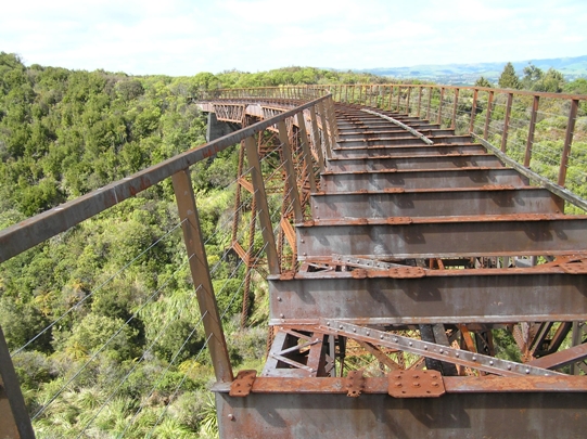
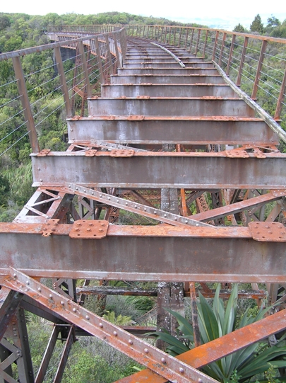
The Taonui Viaduct is a remnant of the significant expertise and resources that were invested NIMT's construction. Like other Peter Seton Hay designed viaducts, the Taonui Viaduct consists of steel lattice and mass concrete piers which are interspersed with Pratt truss and plate steel girders. It is similar in design to the Hapuawhenua Viaduct, although on a smaller scale. When the viaduct was deviated away from, as part of the NIMT electrification during the late 1980s, the decking was removed. However, aside from this change there has been little alteration to the fabric of the superstructure since it was constructed.
The Taonui Viaduct was an integral component in the 'final push' and the completion of the NIMT is of supreme importance in New Zealand because it revolutionised transport and was essential to the country's economic development. The longevity of this outstanding structure can be attributed to the exceptional technical skill and competence of those involved in designing, manufacturing the fabric for, and constructing the Taonui Viaduct. This viaduct is also imbued with historical significance because the railway's deviation away from the structure was a direct result of the electrification of the NIMT which was a defining moment in the railway's history. The viaduct's subsequent retention and inclusion in the Tongariro National Park can be seen as evidence of the increased awareness of New Zealand's rail and engineering heritage.
List Entry Information
Status
Listed
List Entry Status
Historic Place Category 1
Access
Private/No Public Access
List Number
9266
Date Entered
27th March 2009
Date of Effect
27th March 2009
City/District Council
Ruapehu District
Region
Horizons (Manawatū-Whanganui) Region
Extent of List Entry
Extent includes part of the land described as Sec 17 SO 393634 (RT 519049), Wellington Land District, and the structure known as the Taonui Viaduct thereon, including its abutments, as shown in the extent map tabled at the Rarangi Korero Committee meeting on 29 September 2016.
Legal description
Sec 17 SO 393634 (RT 519049), Wellington Land District.
Location Description
When approaching Horopito from the south along State Highway 4 (SH4), enter the township and turn down Matapuna Road, the first street on the right. Immediately over the railway tracks at the junction of Matapuna Road and Horuhoru Terrace turn right into Clydes Access. Travel to the end of this road and park. Then continue on foot following the old railway corridor. You will cross the functioning NIMT once before reaching the viaduct.
Why is this place significant?
Historic Significance
Historical Significance or Value The Taonui Viaduct has outstanding national and local historical importance because of its inclusion in the massive engineering feat which was the NIMT and, more particularly, the last stages of the 'final push' to complete it. The construction of the NIMT took 23 years and was only made possible because of the agreement of some Maori to allow surveying in, and eventually the establishment of the railway reserve through, the restricted area of the Rohe Potae. This access initiated one of the most expensive state projects undertaken in New Zealand; expenditure which was justified by the governments of the time as a means of encouraging immigration to New Zealand, gaining a foothold in the central North Island, and stimulating settlement in the area. Therefore, the NIMT was a major instrument of, and was central to, social and economic change within the Central Plateau and nationally. In particular, the Taonui Viaduct has considerable historical value because it was the first of a series of viaducts completed in the pivotal last portion of the 'final push' section between Ohakune and Erua. Within this last section, the Taonui Viaduct is a rare example of a large scale viaduct built under the 'co-operative system' which was responsible for constructing most of the NIMT, but infrequently used for major structures in the 'final push.' The Taonui Viaduct is also imbued with historical significance because it was directly affected by, and is therefore intricately linked to, the electrification of the NIMT which is the most important change in operations on the railway during the 20th century. As a result of its redundancy from the railway, the viaduct was incorporated into the Tongariro National Park and became a part of the history of New Zealand's first national park and its expansion.
Physical Significance
Technological Significance or Value: There are few large scale curved viaducts in New Zealand and the Taonui Viaduct is an exceptional example being among the highest of this small group of structures. Because of the rarity of this form of steel viaduct, the pairing of the Taonui Viaduct with its contemporary, the Hapuawhenua Viaduct, is unique nationally, and demonstrates how a design could be adapted to differing landscape features. The structure's longevity, with no instances of underpinning, is a tribute to the remarkable technical skill of the designer and workforce. This durability is also indicative of the technical quality of the standardised components manufactured at the PWD workshop. It is a testimony to this technical value that the eventual deviation away from the Taonui Viaduct was because of NIMT-wide operational changes and not any specific structural failing within the viaduct. Aesthetic Significance or Value: The graceful curve and impressive size of the Taonui Viaduct creates a favourable visual effect, especially in contrast to the striking natural landscape in which it is set. This is enhanced by its current situation because the visitor walks through close bush which suddenly opens out, at which point they are confronted with the viaduct, and can also appreciate the gorge and greater landscape. It is anticipated that when the Ohakune to Horopito Coach Road project is completed that the Taonui Viaduct will be an aesthetic asset and highlight of the track.
Why is this place Category 1 / Category 2?
Detail Of Assessed Criteria
(a) The extent to which the place reflects important or representative aspects of New Zealand history: The Taonui Viaduct is an impressive physical remnant of the enormous engineering feat which was the construction of the NIMT. The NIMT was politically and socially important, particularly in the realm of race relations, and also revolutionised transport and the economy. When it was still a functioning part of the NIMT, the Taonui Viaduct was an integral part of these aspects of New Zealand's history. (b) The association of the place with events, persons, or ideas of importance in New Zealand history: The Taonui Viaduct was designed by Peter Seton Hay, the Engineer-in-Chief of the Public Works Department and an important engineer. The Taonui Viaduct is also associated with another important New Zealand engineer, Frederick William Furkert. Furkert was instrumental in the successful and timely completion of the NIMT in his role as the engineer in charge of construction from the southern railhead at Ohakune. Due to the proximity of the viaduct to Ohakune, Furkert was able to visit the site frequently and photographically record its progress. This viaduct is distinguished because it is one of a series of important structures built in the closing stages of the 'final push' to complete the NIMT, and as such it is intricately linked to this event. The Taonui Viaduct is also linked to the 1987 electrification of the NIMT which was a significant event in the New Zealand's rail history. (f) The potential of the place for public education: Currently the viaduct is relatively inaccessible. However, when the Ohakune to Horopito Coach Road project is completed the structure will be incorporated into a walking track which will have a strong rail heritage focus. The Taonui Viaduct is closely linked to the NIMT construction era structures and physical remnants within the track, and also those in the larger 'final push' area. As such, the Taonui Viaduct and this group of structures have the potential to educate the public about New Zealand's engineering heritage, the sections importance to the completion of the NIMT, and the NIMT's place within the broader context of the settlement in the Central Plateau. There will also be an opportunity to highlight the latter history of the Taonui Viaduct, and the NIMT, in explaining the reasons why it and the surrounding land were incorporated into the Tongariro National Park, and also how the park has expanded since its inception. (g) The technical accomplishment or value, or design of the place: The Taonui Viaduct has considerable technical value because of the rarity of curved viaducts in New Zealand and because it is one of the oldest surviving and largest of this small group of structures. The value of the pairing of the Taonui and Hapuawhenua Viaducts demonstrates how standard designs and materials were adapted to meet the individual demands of each site. The close proximity of the replacement viaducts on the Horopito Deviation also creates a valuable comparison between early and late 20th century viaduct engineering and materials. (k) The extent to which the place forms part of a wider historical and cultural complex or historical and cultural landscape: The Taonui Viaduct is one element in the nationally significant network of structures, track, and other associated sites, that form the NIMT between Wellington and Auckland and was of key importance to the railways completion. When the viaduct was subsumed into the Tongariro National Park in the 1980s it also became part of that historically and culturally important landscape. As such, the Taonui Viaduct is an integral part of several wider historical and cultural landscapes which are predominantly important at a local and regional level, but which also span a large section of the North Island. Summary of Significance or Values: This place was assessed against, and found it to qualify under the following criteria: a, b, f, g and k Conclusion: It is considered that this place qualifies as a Category I historic place. The completion of the Taonui Viaduct was the first major obstacle to be overcome in the 'final push' to finish the largest single construction project in New Zealand's history, the NIMT. This railway directly affected the physical and social landscape of the Central Plateau and was integral in the development of New Zealand's economy. The NIMT is a significant engineering feat which is representative of the technologies and best engineering practices of the time. Within this there are several individual structures that are comparable to the Taonui Viaduct in construction material, designer, and/or PWD 'co-operative system' construction that have been singled out as remarkable structures by the New Zealand Historic Places Trust. These are the (Old) Hapuawhenua, Makatote, Makohine, and Waiteti Viaducts, all of which are registered as Category I historic places. Despite commonalities with these structures, and an especially close kinship with the Hapuawhenua Viaduct, the Taonui Viaduct can be considered an outstanding example and engineering success in its own right. The technical accomplishment of curved steel truss viaducts, of which the Taonui is one of the oldest, largest and most impressive, combined with their rarity in New Zealand, imbues this structure with outstanding national significance.
Construction Professional
Name
Hay, Peter Seton
Type
Designer
Biography
Peter Seton Hay (1852/1853? - 1907) was born in Glasgow, Scotland, probably in 1852 or 1853, the son of Janet (Jessie) Dalziel and her husband, James Johnston Hay, a journeyman engineer. When Peter was a child the family emigrated to New Zealand, arriving at Port Chalmers on the Storm Cloud in April 1860. Educated in Dunedin, he was the first graduate of the newly established University of Otago, obtaining a BA in 1877 and an MA with first-class honours in mathematics in 1878. In June 1875 on the advice of a university teacher he had joined the Public Works Department as an engineering cadet. After completing his studies he was engaged in railway surveys and construction for the lines from Dunedin to Moeraki and Clinton. In the early 1880s he was employed on Central Otago railway surveys from Rough Ridge to Hawea, in the Cromwell district, and from Balclutha to the Catlins River. Hay's reputation as a brilliant young engineer was established in these Otago days. Stories were told of his prodigious mental calculations when he was working in the field without the usual aids such as logarithm tables. In 1884 Hay was transferred to the head office of the Public Works Department in Wellington. He began his steady progress through the ranks of the department, and two years later was promoted to resident engineer. In 1896 he was promoted to superintending engineer, equivalent to assistant engineer-in-chief. By then the construction of the North Island main trunk rail link was the foremost Public Works Department project. Hay helped plan most of the important railway works of the central North Island section and was responsible for the primary design of the Makohine, Mangaweka, Hapuawhenua, Taonui, Manganui-a-te-ao and Makatote viaducts. By any standards the viaducts were great works of engineering. Much of the credit for their construction must be attributed to Peter Hay. Hay succeeded W. H. Hales as engineer-in-chief of the Public Works Department in 1906, only to die in office on 19 March 1907. He suffered the effects of exposure while inspecting the main trunk railway works near Waiouru, and subsequently died from pleurisy at his home in Wadestown, Wellington. He was aged 54. One of Hay's major achievements was his investigation and report on the proposed Southern Alps rail crossing by the Midland railway in 1903. The scheme recommended by the government's American advisory engineer, Virgil Gay Bogue, required a 3½-mile tunnel and a steep gradient incline track. Hay's scheme, which was ultimately adopted, avoided expensive grading and track work but required a tunnel over five miles long. This tunnel, at Otira, was completed in 1923, long after Hay's death. Equally important was Hay's contribution to the development of hydroelectric power generation in New Zealand. Peter Seton Hay married Mary Clarke at Wairuna, Otago, on 22 April 1879 and they had four sons and one daughter. His wife and children survived him. Hay was the first New Zealand-trained engineer to rise to the rank of engineer-in-chief. He died at the height of his powers and before many of his projects had been completed. Although his life was relatively brief, his works endured. Lowe, Peter. 'Hay, Peter Seton 1852/1853? - 1907'. Dictionary of New Zealand Biography, updated 16 December 2003 URL: http://www.dnzb.govt.nz/
Name
Furkert, Frederick William.
Type
Engineer
Biography
http://www.dnzb.govt.nz/dnzb/ - search for Furkert.
Construction Details
Start Year
1908
Type
Modification
Description
Rails laid across the viaduct
Start Year
1908
Type
Other
Description
Rails linked to Hapuawhenua Viaduct
Start Year
1934
Type
Modification
Description
Strengthening work carried out
Start Year
1964
Type
Modification
Description
Viaduct painted
Start Year
1971
Type
Modification
Description
Strengthening work carried out
Start Year
1987
Type
Other
Description
Viaduct deviated away from and decking fabric removed
Start Year
1906
startYearCirca
Finish Year
1907
finishYearCirca
Type
Original Construction
Description
Construction of Taonui Viaduct begins
Start Year
1907
Type
Other
Description
Concrete footings completed and steel superstructure partially erected
Start Year
1907
Type
Other
Description
Taonui Viaduct completed
Construction Materials
Steel and concrete
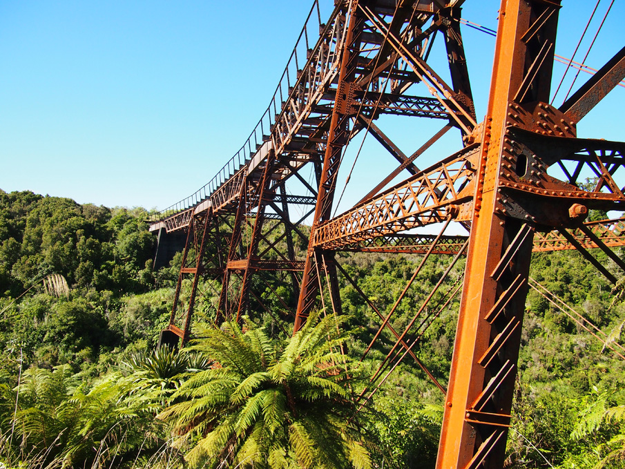
The Taonui Viaduct is situated in the North Island's Central Plateau and crosses the Taonui Stream, south-west of Mount Ruapehu between Ohakune and Horopito. It was constructed as part of the NIMT in 1907 and was a functioning part of that railway for the subsequent 80 years. The Taonui Viaduct is one of a pair of curved steel truss railway viaducts, which is a unique occurrence within New Zealand. The NIMT journey: The concept of the NIMT was promoted by Julius Vogel (1835-1899), then the Colonial Treasurer in William Fox's government, as part of his bold expansionist policy which was adopted by the House in 1870. From a purely practical stand-point, the NIMT was necessary because it established a direct transport route between New Zealand's two major cities, Auckland and Wellington. For the 20 years prior to the NIMT's completion, goods and passenger traffic between these cities was typically directed from Auckland to New Plymouth via coastal shipping and then continued by ship or train onto Wellington and vice versa. This was by no means an ideal, or efficient, means of freight or passenger transport. However, a key part of Vogel's scheme was to use the construction project as the basis for bringing thousands of assisted immigrants to New Zealand. His policy drew heavily on the model formulated in the United States of America, which used railways to gain access to previously remote areas, then to create settlements in these areas using the construction workers as the foundation of the local populous. The NIMT can be viewed as successful realisation of this model and it was also the catalyst for demographic change for the existing Maori population. In the Central Plateau Maori settlement was mostly concentrated around the Manganui-o-te-ao River. However, the NIMT caused a population shift, and by 1900 the various settlements around the river were largely depopulated because many inhabitants gained employment as labourers on the railway. Once construction was complete it appears that local Maori then gravitated toward the newly established NIMT towns. Therefore, the NIMT is responsible for radically changing the social landscape of the Central Plateau. From the mid-1860s Maori in the central North Island had repelled European encroachment by establishing, and staunchly upholding, the restricted area known as the Rohe Potae, and the governments of the late 19th century saw the construction of the NIMT as a tool for gaining access to the King Country. In 1883, after a decade of persistent approaches from the government regarding the area, talks between officials and some King Country chiefs regarding the establishment of the railway through their land began in earnest. A series of rigorous negotiations was then initiated with two Ngati Maniapoto leaders, Wahanui Hautare and Rewi Maniapoto. There seems to have been a feeling that the railway and European incursion into the King Country was inevitable, but these chiefs wanted to make sure that it was on their terms. In late 1884 Wahanui announced his intention to cooperate with the government over the railway, and he laid out a set of conditions before the House of Representative on 1 November 1884. The conditions included the right of the King movement to manage their own affairs, the banning of liquor from Waikato-Ngati Maniapoto territory, the right of his people to have sole responsibility for administering their ancestral lands, and that they were compensated for the land which was used. Following this, in early 1885 surveyors were allowed into the Rohe Potae to locate possible railway routes. Because of the tenuous relationship between the Crown and King Country iwi it was felt that the negotiation process was essential. However, by only consulting with Wahanui and Maniapoto the government purposely side-stepped King Tawhiao and other leaders who opposed the railway. Therefore, this initial agreement was not universal and accordingly there were instances of resistance, such as the destruction of surveying marks. Despite some opposition, surveying and construction plans continued and on 15 April 1885 it was Wahanui who wielded the shovel that turned the NIMT's first sod, which was then ceremonially wheeled away by Premier Robert Stout. Prior to the chiefs allowing surveyors into the Rohe Potae, possible railway corridors through the King Country were only speculative because there had not been any previous opportunity to map it in detail. There were several proposed routes for the NIMT and John Rochfort (1832-1893) surveyed for a possible corridor through the Central Plateau between 1883 and 1887. This was said to be his tour de force because he had to start from scratch and cover a large and topographically complex area. After much debate and delay it was Rochfort's route that NIMT eventually followed. The Maori land that this route required progressively passed into Crown ownership under the Public Works Acts of 1882 and 1894. This legislation stipulated that construction could not begin until the governor issued a proclamation detailing the middle-line that each successive section would take. The initial stages in NIMT history were protracted, and once the route was resolved and the required land obtained, the construction progress followed this early pattern and laboured along. The NIMT was eventually completed in 1908 having taken 23 years to finish due to various political and financial impediments including the economic depression of the 1890s. The slow progress bred public dissatisfaction which had reached such a pitch by 1900 that it motivated parliament to inject significantly more money and manpower to the project in the hope that this would bring it to a quick resolution. This created a last flurry of activity which saw the remaining section between the Makohine Viaduct and Taumarunui completed in just eight years. Towards the end of this period the Government promised that the NIMT would be finished by Christmas 1908 and an indicator of government's apprehension regarding completion is that from late 1907 the Minister for Public Works, William Hall-Jones (1851-1936), began making frequent visits to inspect progress. This last section to be constructed was known as the 'final push' and was not an easy task, despite the increase in resources, because of its difficult geography which was noted for its steep grades, deep ravines, and heavy bush, not to mention the often inclement weather. Given the topography and the almost complete reliance on manual labour for construction, the eight year completion period is remarkable, and it is also not surprising that the 'final push' section has many significant structures. Within this section a majority of structures are concentrated between Ohakune and Raurimu. These include the iconic Makatote and three other surviving viaducts, including the Taonui Viaduct, and important earthworks of which the Raurimu Spiral is an internationally recognised engineering achievement, as well as a number of other tunnels and smaller bridges. Constructing the Taonui Viaduct: The Taonui Viaduct, and its other NIMT contemporaries, are products of the iron and steel construction age of the late 19th and early 20th centuries. The industrial revolution and resulting technologies, such as railways, demanded the development of construction materials which were long lasting, relatively light, and could be mass produced. Iron and steel fulfilled these criteria, but it was not until the late 19th century that a technique was developed which reduced the cost of steel production and made it as cost effective as iron. As a consequence of the international railway boom engineers, such as Gustave Eiffel, pioneered the construction of steel viaducts. From this period, steel fabrication was favoured for viaducts, and other large self-supporting structures. Lightness was particularly important for viaducts 'because it is only in such structures that the weight of the metal forms a prominent item in the strains.' Although, not as monumental as some of Eiffel's viaducts, or even others on the NIMT like the Makatote and Hapuawhenua, the Taonui Viaduct is representative of this trend. It was not until the mid 20th century that viaduct construction using prestressed or reinforced concrete became a predominant material for bridges in New Zealand. Concrete viaducts have now replaced several NIMT ‘final push' construction era viaducts within the functioning railway, including the Taonui, Hapuawhenua, Mangaweka, and Manganui-o-te-ao Viaducts, of which the latter two structures were demolished. The engineer responsible for designing the Taonui Viaduct, and many other ‘final push' structures, was Peter Seton Hay (1852/53-1907). Hay is noteworthy because he was the first person to graduate from the University of Otago with a Bachelor of Arts in 1877. He then joined the Public Works Department (PWD) and gradually progressed through its ranks to become the engineer-in-chief by the time he died prematurely in 1907. Because the Central Plateau would ‘not yield easily to the steam age,' Hay was compelled to design a succession of impressive viaducts in order for the railway to navigate it. Hay's designs for the Makohine, Mangaweka, Hapuawhenua, Taonui, Mangaturuturu, Manganui-o-te-ao, and Makatote viaducts were all based on classic North American trestle viaducts and are recognised, alongside his pioneering research into New Zealand's hydroelectric capabilities, as his most important legacies. Unlike the other five Hay designed viaducts in the ‘final push' section, the Hapuawhenua and Taonui Viaducts are both rare examples of curved structures. Curved viaducts were first built for railways and came out of the railway boom of the mid-late 19th century. Despite the aesthetic appeal of curved viaducts, bridges are primarily meant to be functional structures and therefore curved examples are not common as it was, and still is, more practical to build straight bridges because they are typically easier to construct and have less maintenance costs over time. Within New Zealand there is only a small group of significant curved bridges and viaducts, and the Hapuawhenua and Taonui Viaducts are among the tallest and oldest surviving examples. The design of these two viaducts is closely related including having the same radius curve. However, the Taonui gains some distinction over the Hapuawhenua because it was necessary to build it with a 1 to 60 gradient and it was finished first. Another differential is that the Hapuawhenua Viaduct is the longest remaining NIMT construction era viaduct at 932ft (284m), whereas the Taonui Viaduct is much shorter at 400ft (122m) in length. The close proximity of the two structures and the similarities in their design have led to direct comparisons between them, and the extraordinary aspects of the Hapuawhenua have meant Taonui has understandably been viewed as less spectacular than its sibling. The Taonui Viaduct however has an impressive scale in its own right and is both the sixth highest, and longest remaining NIMT construction era bridge. Taonui and Hapuawhenua Viaducts were built under the ‘co-operative system,' unlike all the other remaining NIMT construction era viaducts between Ohakune and National Park. Most of the NIMT was built using the ‘co-operative system' which saw sections of the railway being divided into manageable chunks for groups of six to twelve workers to complete. This system was a product of contemporary Liberal philosophy and also a result of the government being unhappy with the shoddy results from some public works which had been contracted out. The price paid for each section was determined by the supervising PWD engineer based on standard rates, and then a small percentage was added to this which was calculated in accordance with the profit margin a private contractor would have generally received. Therefore, in theory, labourers could expect to earn more working as part of the ‘co-operative system' than if they worked for a private contractor. The men were paid their wages monthly, based on the amount of their allocated section that they completed. The government supplied the construction materials for the groups and also an overseer, which assured them that materials and workmanship throughout the NIMT were of a consistent standard. However, the extent of this government control also drew criticism particularly because they decided the acceptable rate for the contract and many workers complained that this actually resulted in lower wages than they could earn working for a private firm, like J & A Andersons Ltd which was responsible for the construction of the significant ‘final push' structure, the Makatote Viaduct, and the steel superstructures of the Manganui-o-te-ao and Mangaturuturu Viaducts. A main reason for the contracts for these latter viaducts being let to Andersons was that the PWD workshop at Mangaonoho, which was situated between Hunterville and Taihape and in operation from 1898, was running at full capacity to manufacture the steelwork for the Hapuawhenua and Taonui Viaducts and could not accommodate the extra demand for material. In 1906 the southern railhead had reached Ohakune, and it became the base of operations for the works from that end with the Resident Engineer Frederick William Furkert (1876-1949) working from there. Furkert was under considerable pressure to ensure that work progressed in keeping with the government's expectations, and the fact that the NIMT was finished on schedule in late 1908 has largely been attributed to his efficiency and management skills. Furkert kept a close eye on what was happening and made frequent visits to the Taonui site during construction as is evidenced by the fact that the various phases of the viaduct's construction, and that of the Hapuawhenua, were photographically documented by Furkert. With Ohakune as the railhead and reasonably close to the viaduct site, the fabric for the viaduct was railed from the Mangaonoho Workshop to Ohakune, and then transported over a temporary railway that was constructed to the Hapuawhenua Viaduct, before being hauled over a service road to the Taonui site. Work on the Taonui Viaduct was begun by early 1907 and completed late in that year. Like other NIMT construction era viaducts its construction relied heavily on manual labour, and because it and the Hapuawhenua Viaduct were curved, they had to be built differently to straight contemporaneous NIMT viaducts. The straight viaducts were generally built one pier at a time from edges inwards with the girders being placed as each couplet of piers was completed. However, the Taonui Viaduct's piers were built in a synchronised fashion, one tier at a time from the ground up using a series of guy lines attached to hoisting machines, called derricks, and then all the girders were raised into position last. Therefore, instead of construction being aided by being able to progressively walk further out onto the viaduct throughout construction, access to the pier heads at Taonui and Hapuawhenua was via very tall ladders. This construction technique also meant that there was a heightened level of accuracy and precision needed in order to secure the components of each pier on the correct alignment and in manipulating the hoisting system. However, this finesse was combined with a certain amount of brute strength. For example, the pier head girders weighed about three and a half tons, and the truss girder approximately nine and half tons, and these were positioned using the manually operated derricks. This method was said to be ‘much cheaper and more expeditious than the overhead cableway used at several of the other viaducts' on the NIMT, which from the Government's point of view no doubt justified this method. Workers at the Taonui site not only endured the intense physical labour that was needed to construct the viaduct, but also the elements. Each section of line and every major structure on the NIMT had a corresponding camp where the labourers, and sometimes their families, lived. These camps were typically populated with the tents which were standard PWD issue, as were picks, long handled shovels, and axes; the hand tools responsible for building most of the NIMT. Like workers at the other camps in this high altitude area, those on the north-western ridge at the Taonui site would have been subjected to the freezing temperatures and wet weather which often hindered progress, although it does not appear to have restricted progress at Taonui to the same extent that it did at other sites, like the Makatote Viaduct. Travel, tourism, and the Taonui Viaduct: The completion of the Horopito to Ohakune Coach Road in 1906, and other roads between the railheads, meant that people began to use the NIMT route for travel, and accounts often featured in the newspapers of the day with first hand reports of the progress of construction, and travel adventures and highlights. In such accounts the Taonui Viaduct was described as a tall viaduct with a ‘half-moon sweep' at the top of a grade. Because Taonui had been decked by early 1908, coach passengers could elect to walk across it while the coach wound its way around the road underneath. It was said that despite the viaduct being high, there was sense of security for those ‘adventurous spirits' who took this option because of the steel and wire handrail on the viaduct. At this time the activity was a novelty in the district because the Taonui was the first of five viaducts in the crucial last portion of the NIMT to be finished. Rails were laid across the Taonui Viaduct by February 1908, but because it was completed before its southern neighbour, the Hapuawhenua Viaduct, the rails could not be connected to those from the southern railhead until after the Hapuawhenua was completed in April 1908. The progression of the railway over these structures saw one of the last major geographical impediments in the NIMT finally conquered, and lead to the line being passable for the first Wellington to Auckland train journey, the ‘Parliamentary Special' in August 1908. Earlier in 1908 the viaduct was threatened by extensive bush fires in the Waimarino district, but no specific damage was recorded. In the early 20th century bush fires in the area seem to have been a significant problem and frequent occurrence, and in March 1918 the Taonui Viaduct was again in the middle of such an event. The series of bush fires ablaze on 18 and 19 March is often referred to as the Raetihi Fire, but fires sprung up across the breadth of the district. Newspaper reports indicate that 70 feet of sleepers and some of the parapet on the viaduct were damaged by a fire on the structure which caused a truck of a goods train to also catch fire. This occurred just prior to the express from Auckland being due to cross the viaduct and as a result it was stopped at Horopito. However, by the next day the sleepers were said to have been replaced and train services resumed. This quick response to disruptive damage demonstrates the importance of the NIMT to passenger and goods traffic, and communications during the early 20th century, and that the Taonui Viaduct was a vital component in this. There were relatively few alterations to the Taonui Viaduct for 70 years until plans for electrifying the NIMT came into effect in the early 1980s. It was then that a decision was made to bypass both the Hapuawhenua and Taonui Viaducts with a 10km deviation. Because electrification meant the inception of trains which could travel at faster speeds it was necessary to exclude any avoidable tight curves and steep grades to ensure the locomotives could maintain a constant velocity. As early as the mid-1960s there had been calls to bypass the Hapuawhenua and Taonui Viaducts for the good of the smooth and efficient operating on the NIMT. The main reason sited for this was that since the 1930s there had been a speed restriction of 20mph (32kph) on each of the structures due to their small radiuses and a deviation would also reduce maintenance costs, and the risk of derailment. An added incentive for deviation was that the Hapuawhenua Viaduct required costly underpinning if it was to continue to be viable within the functioning railway. Therefore the Horopito Deviation, completed in 1987, was a practical and logical solution. Included in the bypass were two replacement viaducts for the NIMT construction era Taonui and Hapuawhenua Viaducts. Unlike the Hapuawhenua's replacement, the new Taonui Viaduct's design did not mirror the curve of the original structure and is a straight concrete viaduct. When the deviation was opened for traffic, the Taonui had its rails and decking removed and some of the original cuttings leading to the viaduct were filled with spoil from the new deviation. As part of the planning for the deviation possible uses for the NIMT construction era structures were considered, and it was decided that they would be retained and placed under DoC management to eventually be incorporated into a walking track. The land immediately surrounding the viaducts had become part of the Tongariro National Park in 1916, therefore, a like for like swap of land between DoC and the Railways Department was a logical arrangement when plans for the deviation were being devised. This also meant that the walking track would feature unique structural highlights that, when combined with natural features, it was anticipated would make it an appealing tourist attraction. The Taonui Viaduct was singled out as an integral aesthetic component in the proposed track because it affords excellent views of Mount Ruapehu, and its scale and form complements the grand landscape in which is set. The loss of purpose of the viaduct with the deviation, and the subsequent passive management of the structure by DoC, has resulted in access to the Taonui Viaduct being difficult due to overgrown scrub and also surface deterioration from having no maintenance since 1987. The access problem will be resolved when the Ohakune to Horopito Old Coach Road project is concluded. The first of three stages for this project is almost complete. When the walking track is finished the Taonui Viaduct, like the Hapuawhenua, may have timber laid on it so it can be walked across, but at the very least a viewing platform will be constructed so that its aesthetic and heritage values can be appreciated by the public.
The Taonui Viaduct is situated in the North Island's Central Plateau and crosses the Taonui Stream, south-west of Mount Ruapehu between Ohakune and Horopito. It was constructed as part of the NIMT in 1907 and was a functioning part of that railway for the subsequent 80 years. The Taonui Viaduct is one of a pair of curved steel truss railway viaducts, which is a unique occurrence within New Zealand. The NIMT journey: The concept of the NIMT was promoted by Julius Vogel (1835-1899), then the Colonial Treasurer in William Fox's government, as part of his bold expansionist policy which was adopted by the House in 1870. From a purely practical stand-point, the NIMT was necessary because it established a direct transport route between New Zealand's two major cities, Auckland and Wellington. For the 20 years prior to the NIMT's completion, goods and passenger traffic between these cities was typically directed from Auckland to New Plymouth via coastal shipping and then continued by ship or train onto Wellington and vice versa. This was by no means an ideal, or efficient, means of freight or passenger transport. However, a key part of Vogel's scheme was to use the construction project as the basis for bringing thousands of assisted immigrants to New Zealand. His policy drew heavily on the model formulated in the United States of America, which used railways to gain access to previously remote areas, then to create settlements in these areas using the construction workers as the foundation of the local populous. The NIMT can be viewed as successful realisation of this model and it was also the catalyst for demographic change for the existing Maori population. In the Central Plateau Maori settlement was mostly concentrated around the Manganui-o-te-ao River. However, the NIMT caused a population shift, and by 1900 the various settlements around the river were largely depopulated because many inhabitants gained employment as labourers on the railway. Once construction was complete it appears that local Maori then gravitated toward the newly established NIMT towns. Therefore, the NIMT is responsible for radically changing the social landscape of the Central Plateau. From the mid-1860s Maori in the central North Island had repelled European encroachment by establishing, and staunchly upholding, the restricted area known as the Rohe Potae, and the governments of the late 19th century saw the construction of the NIMT as a tool for gaining access to the King Country. In 1883, after a decade of persistent approaches from the government regarding the area, talks between officials and some King Country chiefs regarding the establishment of the railway through their land began in earnest. A series of rigorous negotiations was then initiated with two Ngati Maniapoto leaders, Wahanui Hautare and Rewi Maniapoto. There seems to have been a feeling that the railway and European incursion into the King Country was inevitable, but these chiefs wanted to make sure that it was on their terms. In late 1884 Wahanui announced his intention to cooperate with the government over the railway, and he laid out a set of conditions before the House of Representative on 1 November 1884. The conditions included the right of the King movement to manage their own affairs, the banning of liquor from Waikato-Ngati Maniapoto territory, the right of his people to have sole responsibility for administering their ancestral lands, and that they were compensated for the land which was used. Following this, in early 1885 surveyors were allowed into the Rohe Potae to locate possible railway routes. Because of the tenuous relationship between the Crown and King Country iwi it was felt that the negotiation process was essential. However, by only consulting with Wahanui and Maniapoto the government purposely side-stepped King Tawhiao and other leaders who opposed the railway. Therefore, this initial agreement was not universal and accordingly there were instances of resistance, such as the destruction of surveying marks. Despite some opposition, surveying and construction plans continued and on 15 April 1885 it was Wahanui who wielded the shovel that turned the NIMT's first sod, which was then ceremonially wheeled away by Premier Robert Stout. Prior to the chiefs allowing surveyors into the Rohe Potae, possible railway corridors through the King Country were only speculative because there had not been any previous opportunity to map it in detail. There were several proposed routes for the NIMT and John Rochfort (1832-1893) surveyed for a possible corridor through the Central Plateau between 1883 and 1887. This was said to be his tour de force because he had to start from scratch and cover a large and topographically complex area. After much debate and delay it was Rochfort's route that NIMT eventually followed. The Maori land that this route required progressively passed into Crown ownership under the Public Works Acts of 1882 and 1894. This legislation stipulated that construction could not begin until the governor issued a proclamation detailing the middle-line that each successive section would take. The initial stages in NIMT history were protracted, and once the route was resolved and the required land obtained, the construction progress followed this early pattern and laboured along. The NIMT was eventually completed in 1908 having taken 23 years to finish due to various political and financial impediments including the economic depression of the 1890s. The slow progress bred public dissatisfaction which had reached such a pitch by 1900 that it motivated parliament to inject significantly more money and manpower to the project in the hope that this would bring it to a quick resolution. This created a last flurry of activity which saw the remaining section between the Makohine Viaduct and Taumarunui completed in just eight years. Towards the end of this period the Government promised that the NIMT would be finished by Christmas 1908 and an indicator of government's apprehension regarding completion is that from late 1907 the Minister for Public Works, William Hall-Jones (1851-1936), began making frequent visits to inspect progress. This last section to be constructed was known as the 'final push' and was not an easy task, despite the increase in resources, because of its difficult geography which was noted for its steep grades, deep ravines, and heavy bush, not to mention the often inclement weather. Given the topography and the almost complete reliance on manual labour for construction, the eight year completion period is remarkable, and it is also not surprising that the 'final push' section has many significant structures. Within this section a majority of structures are concentrated between Ohakune and Raurimu. These include the iconic Makatote and three other surviving viaducts, including the Taonui Viaduct, and important earthworks of which the Raurimu Spiral is an internationally recognised engineering achievement, as well as a number of other tunnels and smaller bridges. Constructing the Taonui Viaduct: The Taonui Viaduct, and its other NIMT contemporaries, are products of the iron and steel construction age of the late 19th and early 20th centuries. The industrial revolution and resulting technologies, such as railways, demanded the development of construction materials which were long lasting, relatively light, and could be mass produced. Iron and steel fulfilled these criteria, but it was not until the late 19th century that a technique was developed which reduced the cost of steel production and made it as cost effective as iron. As a consequence of the international railway boom engineers, such as Gustave Eiffel, pioneered the construction of steel viaducts. From this period, steel fabrication was favoured for viaducts, and other large self-supporting structures. Lightness was particularly important for viaducts 'because it is only in such structures that the weight of the metal forms a prominent item in the strains.' Although, not as monumental as some of Eiffel's viaducts, or even others on the NIMT like the Makatote and Hapuawhenua, the Taonui Viaduct is representative of this trend. It was not until the mid 20th century that viaduct construction using prestressed or reinforced concrete became a predominant material for bridges in New Zealand. Concrete viaducts have now replaced several NIMT ‘final push' construction era viaducts within the functioning railway, including the Taonui, Hapuawhenua, Mangaweka, and Manganui-o-te-ao Viaducts, of which the latter two structures were demolished. The engineer responsible for designing the Taonui Viaduct, and many other ‘final push' structures, was Peter Seton Hay (1852/53-1907). Hay is noteworthy because he was the first person to graduate from the University of Otago with a Bachelor of Arts in 1877. He then joined the Public Works Department (PWD) and gradually progressed through its ranks to become the engineer-in-chief by the time he died prematurely in 1907. Because the Central Plateau would ‘not yield easily to the steam age,' Hay was compelled to design a succession of impressive viaducts in order for the railway to navigate it. Hay's designs for the Makohine, Mangaweka, Hapuawhenua, Taonui, Mangaturuturu, Manganui-o-te-ao, and Makatote viaducts were all based on classic North American trestle viaducts and are recognised, alongside his pioneering research into New Zealand's hydroelectric capabilities, as his most important legacies. Unlike the other five Hay designed viaducts in the ‘final push' section, the Hapuawhenua and Taonui Viaducts are both rare examples of curved structures. Curved viaducts were first built for railways and came out of the railway boom of the mid-late 19th century. Despite the aesthetic appeal of curved viaducts, bridges are primarily meant to be functional structures and therefore curved examples are not common as it was, and still is, more practical to build straight bridges because they are typically easier to construct and have less maintenance costs over time. Within New Zealand there is only a small group of significant curved bridges and viaducts, and the Hapuawhenua and Taonui Viaducts are among the tallest and oldest surviving examples. The design of these two viaducts is closely related including having the same radius curve. However, the Taonui gains some distinction over the Hapuawhenua because it was necessary to build it with a 1 to 60 gradient and it was finished first. Another differential is that the Hapuawhenua Viaduct is the longest remaining NIMT construction era viaduct at 932ft (284m), whereas the Taonui Viaduct is much shorter at 400ft (122m) in length. The close proximity of the two structures and the similarities in their design have led to direct comparisons between them, and the extraordinary aspects of the Hapuawhenua have meant Taonui has understandably been viewed as less spectacular than its sibling. The Taonui Viaduct however has an impressive scale in its own right and is both the sixth highest, and longest remaining NIMT construction era bridge. Taonui and Hapuawhenua Viaducts were built under the ‘co-operative system,' unlike all the other remaining NIMT construction era viaducts between Ohakune and National Park. Most of the NIMT was built using the ‘co-operative system' which saw sections of the railway being divided into manageable chunks for groups of six to twelve workers to complete. This system was a product of contemporary Liberal philosophy and also a result of the government being unhappy with the shoddy results from some public works which had been contracted out. The price paid for each section was determined by the supervising PWD engineer based on standard rates, and then a small percentage was added to this which was calculated in accordance with the profit margin a private contractor would have generally received. Therefore, in theory, labourers could expect to earn more working as part of the ‘co-operative system' than if they worked for a private contractor. The men were paid their wages monthly, based on the amount of their allocated section that they completed. The government supplied the construction materials for the groups and also an overseer, which assured them that materials and workmanship throughout the NIMT were of a consistent standard. However, the extent of this government control also drew criticism particularly because they decided the acceptable rate for the contract and many workers complained that this actually resulted in lower wages than they could earn working for a private firm, like J & A Andersons Ltd which was responsible for the construction of the significant ‘final push' structure, the Makatote Viaduct, and the steel superstructures of the Manganui-o-te-ao and Mangaturuturu Viaducts. A main reason for the contracts for these latter viaducts being let to Andersons was that the PWD workshop at Mangaonoho, which was situated between Hunterville and Taihape and in operation from 1898, was running at full capacity to manufacture the steelwork for the Hapuawhenua and Taonui Viaducts and could not accommodate the extra demand for material. In 1906 the southern railhead had reached Ohakune, and it became the base of operations for the works from that end with the Resident Engineer Frederick William Furkert (1876-1949) working from there. Furkert was under considerable pressure to ensure that work progressed in keeping with the government's expectations, and the fact that the NIMT was finished on schedule in late 1908 has largely been attributed to his efficiency and management skills. Furkert kept a close eye on what was happening and made frequent visits to the Taonui site during construction as is evidenced by the fact that the various phases of the viaduct's construction, and that of the Hapuawhenua, were photographically documented by Furkert. With Ohakune as the railhead and reasonably close to the viaduct site, the fabric for the viaduct was railed from the Mangaonoho Workshop to Ohakune, and then transported over a temporary railway that was constructed to the Hapuawhenua Viaduct, before being hauled over a service road to the Taonui site. Work on the Taonui Viaduct was begun by early 1907 and completed late in that year. Like other NIMT construction era viaducts its construction relied heavily on manual labour, and because it and the Hapuawhenua Viaduct were curved, they had to be built differently to straight contemporaneous NIMT viaducts. The straight viaducts were generally built one pier at a time from edges inwards with the girders being placed as each couplet of piers was completed. However, the Taonui Viaduct's piers were built in a synchronised fashion, one tier at a time from the ground up using a series of guy lines attached to hoisting machines, called derricks, and then all the girders were raised into position last. Therefore, instead of construction being aided by being able to progressively walk further out onto the viaduct throughout construction, access to the pier heads at Taonui and Hapuawhenua was via very tall ladders. This construction technique also meant that there was a heightened level of accuracy and precision needed in order to secure the components of each pier on the correct alignment and in manipulating the hoisting system. However, this finesse was combined with a certain amount of brute strength. For example, the pier head girders weighed about three and a half tons, and the truss girder approximately nine and half tons, and these were positioned using the manually operated derricks. This method was said to be ‘much cheaper and more expeditious than the overhead cableway used at several of the other viaducts' on the NIMT, which from the Government's point of view no doubt justified this method. Workers at the Taonui site not only endured the intense physical labour that was needed to construct the viaduct, but also the elements. Each section of line and every major structure on the NIMT had a corresponding camp where the labourers, and sometimes their families, lived. These camps were typically populated with the tents which were standard PWD issue, as were picks, long handled shovels, and axes; the hand tools responsible for building most of the NIMT. Like workers at the other camps in this high altitude area, those on the north-western ridge at the Taonui site would have been subjected to the freezing temperatures and wet weather which often hindered progress, although it does not appear to have restricted progress at Taonui to the same extent that it did at other sites, like the Makatote Viaduct. Travel, tourism, and the Taonui Viaduct: The completion of the Horopito to Ohakune Coach Road in 1906, and other roads between the railheads, meant that people began to use the NIMT route for travel, and accounts often featured in the newspapers of the day with first hand reports of the progress of construction, and travel adventures and highlights. In such accounts the Taonui Viaduct was described as a tall viaduct with a ‘half-moon sweep' at the top of a grade. Because Taonui had been decked by early 1908, coach passengers could elect to walk across it while the coach wound its way around the road underneath. It was said that despite the viaduct being high, there was sense of security for those ‘adventurous spirits' who took this option because of the steel and wire handrail on the viaduct. At this time the activity was a novelty in the district because the Taonui was the first of five viaducts in the crucial last portion of the NIMT to be finished. Rails were laid across the Taonui Viaduct by February 1908, but because it was completed before its southern neighbour, the Hapuawhenua Viaduct, the rails could not be connected to those from the southern railhead until after the Hapuawhenua was completed in April 1908. The progression of the railway over these structures saw one of the last major geographical impediments in the NIMT finally conquered, and lead to the line being passable for the first Wellington to Auckland train journey, the ‘Parliamentary Special' in August 1908. Earlier in 1908 the viaduct was threatened by extensive bush fires in the Waimarino district, but no specific damage was recorded. In the early 20th century bush fires in the area seem to have been a significant problem and frequent occurrence, and in March 1918 the Taonui Viaduct was again in the middle of such an event. The series of bush fires ablaze on 18 and 19 March is often referred to as the Raetihi Fire, but fires sprung up across the breadth of the district. Newspaper reports indicate that 70 feet of sleepers and some of the parapet on the viaduct were damaged by a fire on the structure which caused a truck of a goods train to also catch fire. This occurred just prior to the express from Auckland being due to cross the viaduct and as a result it was stopped at Horopito. However, by the next day the sleepers were said to have been replaced and train services resumed. This quick response to disruptive damage demonstrates the importance of the NIMT to passenger and goods traffic, and communications during the early 20th century, and that the Taonui Viaduct was a vital component in this. There were relatively few alterations to the Taonui Viaduct for 70 years until plans for electrifying the NIMT came into effect in the early 1980s. It was then that a decision was made to bypass both the Hapuawhenua and Taonui Viaducts with a 10km deviation. Because electrification meant the inception of trains which could travel at faster speeds it was necessary to exclude any avoidable tight curves and steep grades to ensure the locomotives could maintain a constant velocity. As early as the mid-1960s there had been calls to bypass the Hapuawhenua and Taonui Viaducts for the good of the smooth and efficient operating on the NIMT. The main reason sited for this was that since the 1930s there had been a speed restriction of 20mph (32kph) on each of the structures due to their small radiuses and a deviation would also reduce maintenance costs, and the risk of derailment. An added incentive for deviation was that the Hapuawhenua Viaduct required costly underpinning if it was to continue to be viable within the functioning railway. Therefore the Horopito Deviation, completed in 1987, was a practical and logical solution. Included in the bypass were two replacement viaducts for the NIMT construction era Taonui and Hapuawhenua Viaducts. Unlike the Hapuawhenua's replacement, the new Taonui Viaduct's design did not mirror the curve of the original structure and is a straight concrete viaduct. When the deviation was opened for traffic, the Taonui had its rails and decking removed and some of the original cuttings leading to the viaduct were filled with spoil from the new deviation. As part of the planning for the deviation possible uses for the NIMT construction era structures were considered, and it was decided that they would be retained and placed under DoC management to eventually be incorporated into a walking track. The land immediately surrounding the viaducts had become part of the Tongariro National Park in 1916, therefore, a like for like swap of land between DoC and the Railways Department was a logical arrangement when plans for the deviation were being devised. This also meant that the walking track would feature unique structural highlights that, when combined with natural features, it was anticipated would make it an appealing tourist attraction. The Taonui Viaduct was singled out as an integral aesthetic component in the proposed track because it affords excellent views of Mount Ruapehu, and its scale and form complements the grand landscape in which is set. The loss of purpose of the viaduct with the deviation, and the subsequent passive management of the structure by DoC, has resulted in access to the Taonui Viaduct being difficult due to overgrown scrub and also surface deterioration from having no maintenance since 1987. The access problem will be resolved when the Ohakune to Horopito Old Coach Road project is concluded. The first of three stages for this project is almost complete. When the walking track is finished the Taonui Viaduct, like the Hapuawhenua, may have timber laid on it so it can be walked across, but at the very least a viewing platform will be constructed so that its aesthetic and heritage values can be appreciated by the public.
Construction Professionals: Designer - Peter Seton Hay (See DNZB entry) Supervising Engineer - Frederick William Furkert (See DNZB entry) The specific labourers and overseeing engineer are unknown, although since I.I. Vickerman was the overseer in charge of the Hapuawhenua Viaduct's construction he may have performed the same role at Taonui. All of the workmen were PWD employees under the 'co-operative system.' The Taonui Viaduct is a steel Pratt truss viaduct constructed with a 201m radius curve on a 1 to 60 gradient. At its highest point the viaduct stands 111ft (44m) above the river bed. The three central lattice steel piers are set on mass concrete footings. At the southern end of the viaduct is a flanking mass concrete pier and both of the abutments are in the same material. Between the southern abutment and concrete pier is a 36ft (11m) plate steel span which is repeated on the pier headings of the three steel piers. Each pier is interspersed with a 64ft (20m) Pratt truss steel girder so that the overall length of the viaduct is 400ft (122m). The viaduct is very close to its original form and only underwent a few significant additions. These include strengthening in 1934 to compensate for the heavier locomotives which were being introduced, and then again in 1971 for the same reasons. In the intervening years it was painted at least once but this has mostly worn away to reveal a red lead-based primer. The only substantive change to the appearance and fabric of the viaduct occurred as a result of exclusion from the operating railway in 1987. At this time the decking fabric was removed. While some construction era fabric may have been included in this it is most likely that, because of ongoing maintenance, this would have been from later time periods. Because it was deviated away from before electrification, unlike other viaducts on the NIMT, the Taonui Viaduct does not have any of the associated additions to its fabric. Because there was only a small amount of structural work done on the viaduct, and because the decking was removed, a significant proportion of the remaining fabric dates from 1907, including the handrail. Due to the structure's loss of purpose and DoC's passive management, the structure's paint has deteriorated with almost all of the lead-based red primer of the mid-1960s paint being currently exposed. This red is heightened further by instances of rust. Despite disuse, the structure appears to be sound, although the footings could be adversely affected by moisture being trapped by the scrub which has grown up and around them.
Construction Professionals: Designer - Peter Seton Hay (See DNZB entry) Supervising Engineer - Frederick William Furkert (See DNZB entry) The specific labourers and overseeing engineer are unknown, although since I.I. Vickerman was the overseer in charge of the Hapuawhenua Viaduct's construction he may have performed the same role at Taonui. All of the workmen were PWD employees under the 'co-operative system.' The Taonui Viaduct is a steel Pratt truss viaduct constructed with a 201m radius curve on a 1 to 60 gradient. At its highest point the viaduct stands 111ft (44m) above the river bed. The three central lattice steel piers are set on mass concrete footings. At the southern end of the viaduct is a flanking mass concrete pier and both of the abutments are in the same material. Between the southern abutment and concrete pier is a 36ft (11m) plate steel span which is repeated on the pier headings of the three steel piers. Each pier is interspersed with a 64ft (20m) Pratt truss steel girder so that the overall length of the viaduct is 400ft (122m). The viaduct is very close to its original form and only underwent a few significant additions. These include strengthening in 1934 to compensate for the heavier locomotives which were being introduced, and then again in 1971 for the same reasons. In the intervening years it was painted at least once but this has mostly worn away to reveal a red lead-based primer. The only substantive change to the appearance and fabric of the viaduct occurred as a result of exclusion from the operating railway in 1987. At this time the decking fabric was removed. While some construction era fabric may have been included in this it is most likely that, because of ongoing maintenance, this would have been from later time periods. Because it was deviated away from before electrification, unlike other viaducts on the NIMT, the Taonui Viaduct does not have any of the associated additions to its fabric. Because there was only a small amount of structural work done on the viaduct, and because the decking was removed, a significant proportion of the remaining fabric dates from 1907, including the handrail. Due to the structure's loss of purpose and DoC's passive management, the structure's paint has deteriorated with almost all of the lead-based red primer of the mid-1960s paint being currently exposed. This red is heightened further by instances of rust. Despite disuse, the structure appears to be sound, although the footings could be adversely affected by moisture being trapped by the scrub which has grown up and around them.
Historical and Associated Iwi / Hapū / Whānau
Completion Date
11th February 2009
Report Written By
Karen Astwood
Information Sources
Appendices to the Journals of the House of Representatives (AJHR)
Appendices to the Journals of the House of Representatives
Alexander Turnbull Library
Alexander Turnbull Library, Wellington
Archives New Zealand (Wgtn)
Archives New Zealand (Wellington)
Dictionary of New Zealand Biography
Dictionary of New Zealand Biography
Evening Post
Evening Post, 27 Jun 1919, p.7.
Waitangi Tribunal
Waitangi Tribunal Report, www.waitangi-tribunal.govt.nz
ONTRACK
ONTRACK Wellington
Papers Past
Papers Past, www.paperspast.natlib.govt.nz
Other Information
A fully referenced registration report is available from the NZHPT Central Region office. Please note that entry on the New Zealand Heritage List/Rarangi Korero identifies only the heritage values of the property concerned, and should not be construed as advice on the state of the property, or as a comment of its soundness or safety, including in regard to earthquake risk, safety in the event of fire, or insanitary conditions.
Former Usages
General Usage: Transport
Specific Usage: Bridge/ Viaduct
Themes
North Island Main Trunk Line
Former Usages
General Usage: Transport
Specific Usage: Bridge/ Viaduct
Themes
North Island Main Trunk Line
Location
Related listings
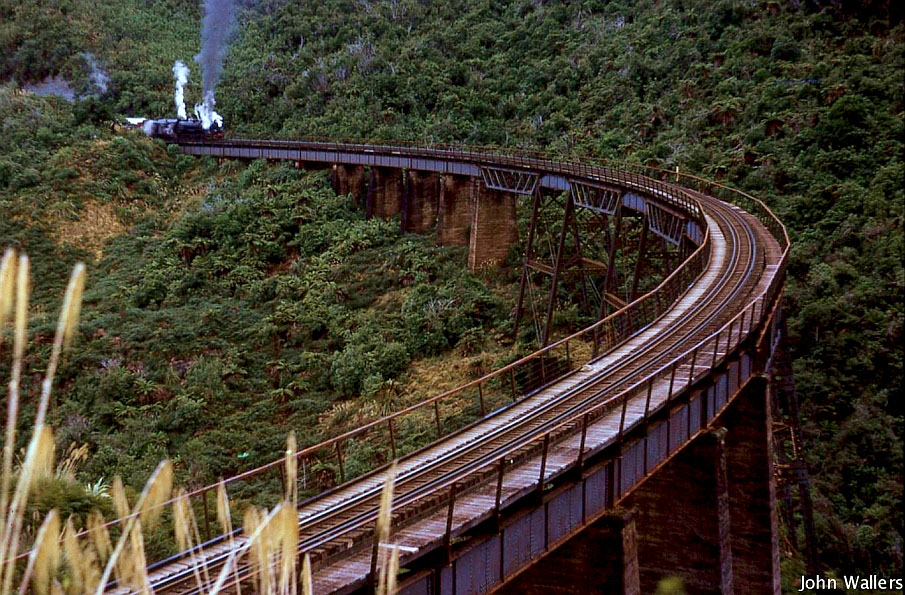
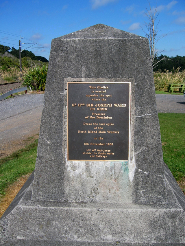
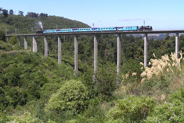
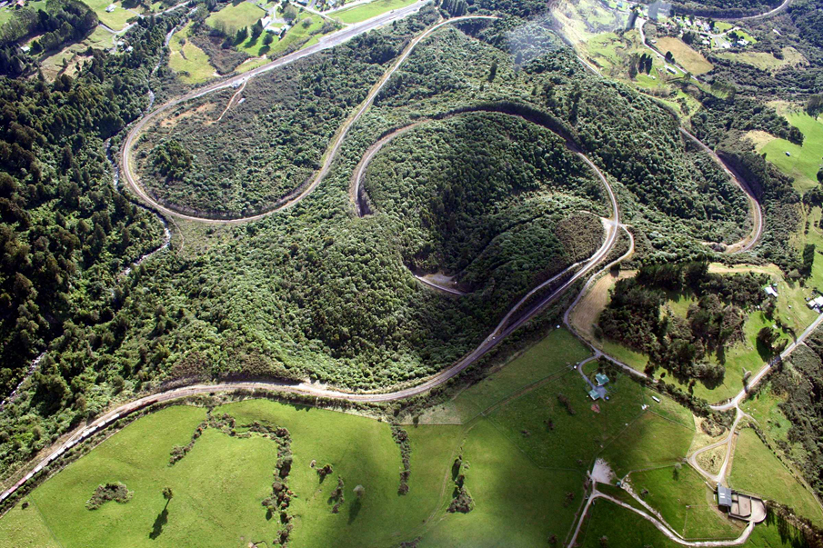
Sign up to hear more
Get the latest heritage news, features and events delivered
straight to your inbox.
