

Located in the picturesque Kauaeranga Valley, near Thames, the small timber building was built by local settlers in 1902 for use as both a schoolroom and a public hall. It was erected on a site in the central part of the valley, equidistant between the home of its furthest-flung pupils and a neighbouring school.
Prior to European arrival the valley was an important place of settlement for Ngati Maru. From the 1870s until the late 1920s it became a major centre for kauri logging, which was one of northern New Zealand's main export industries. By the end of the nineteenth century, incoming settlers included bushmen, farmers and traders. Initial schooling was provided at Parawai, a former mission station at the mouth of the valley. Petitions for a new school in the Kauaeranga were made to the Auckland Education Board (AEB) in 1896, involving prominent citizens such as Thomas Kilgour, a local contractor for the Kauri Timber Company. In general, the 1890s saw a growing concern for child development and welfare in New Zealand, including education. AEB resources were particularly stretched by expanding settlement in rural areas south of Auckland. After land was provided by another resident, Jeannie Murdoch, the AEB undertook to open a school in the Kauaeranga on condition that the community erect a suitable building.
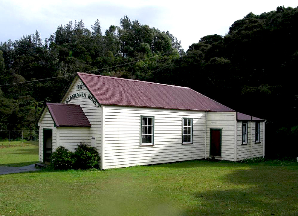
The new structure was erected on a 0.4 hectare (1 acre) site, bounded on one side by the main access route through the valley and on two other sides by a water race used by the timber industry. Measuring 8 m x 5.5 m (26 x 18 '), the simple weatherboarded structure was rectangular in plan and gabled at each end. The structure incorporated a morticed and tenoned timber frame and is likely to have been constructed of local kauri. Plainer in its external appearance than many structures designed and built by the AEB in the late nineteenth century, the building contained a single room larger than that required for its initial roll. It is possible that local people designed, built and provided the materials for the building given their close links with the timber industry and associated construction works in the valley.
From the outset, the building was used as a public hall as well as a school. As a community asset, it was rented out to the AEB for a small fee. The school opened in March 1903, and by December it had a roll of 30 pupils. The first schoolteacher was Griffith Jones, who went on to serve in the First World War (1914-18). Early modifications appear to have included the addition of a large shelter shed in the grounds, possibly relocated from nearby Parawai. By the late 1920s more substantial additions were undertaken involving the enlargement of the schoolroom and possibly the provision of cloakrooms and other facilities in rear annexes. Following the collapse of the timber industry in 1928 and the subsequent General Depression, the number of pupils on the roll declined. An increasing proportion of Dalmatian and Maori children attended, partly linked to a growing emphasis in the valley on gum-digging activities. In 1933-34, a tennis court was constructed, reflecting a growing emphasis on outdoor activity and physical education.
Shortly before closure of the school in 1946, the building was used as an occasional venue for religious services and retained an important ongoing role as the valley's main venue for social gathering and activities. These have included live music, barn dances, children's parties, mid winter dinners and physical activities such as volley ball, badminton and tennis. The former school has also been at the centre of local politics as a polling booth and meeting place. The building celebrated its centenary in 2002 when past pupils signed a built-in backboard in the main hall. The place remains the main focal point for social events in the valley and is one of the area's only public buildings.
The former Kauaeranga Valley School is considered to have architectural value as a surviving example of a combined purpose-built school and community hall in the broader Auckland region, and as a well-preserved example of a single-classroomed rural school from the early to mid twentieth century. It has historical significance for its connections with the development of the Kauaeranga Valley, one of the main kauri-logging areas in late nineteenth- and early twentieth-century New Zealand. The place reflects the expansion of state education in early twentieth-century New Zealand, and demonstrates aspects of self-help and a desire for betterment through education among rural industrial communities. Its history reflects aspects of New Zealand's cultural diversity, including the arrival of Dalmatian migrants. The place has strong social significance as a major place of gathering and congregation for the Kauaeranga Valley community for more than a century.
List Entry Information
Status
Listed
List Entry Status
Historic Place Category 2
Access
Private/No Public Access
List Number
9278
Date Entered
27th March 2009
Date of Effect
27th March 2009
City/District Council
Thames-Coromandel District
Region
Waikato Region
Extent of List Entry
Extent includes the land described as DP 5052 (RT SA176/18), South Auckland Land District and the former school building, shelter shed, tennis court and associated steps and small storage shed thereon, and their fittings and fixtures and the following chattels: framed 1914-18 Roll of Honour, framed 1937 'The King to His People' Coronation Message and wooden table (Refer to map in Appendix 1 of the registration report for further information).
Legal description
DP 5052 (RT SA176/18), South Auckland Land District
Location Description
On the western side of Kauaeranga Valley Road, approximately 500m to the south of its junction with Mangotahi Road. Note that the land parcel is also described as 'Pt Ohaene, South Auckland Land District'.
Why is this place significant?
Cultural Significance
Social Significance or Value: The place has strong social significance as a major place of gathering and congregation for the Kauaeranga Valley community for more than a century. It remains the main focal point for social events in the valley. It also has social value for reflecting important aspects of local identity, including communal activity and self-help.
Historic Significance
Historical Significance or Value The place is historically significant for its connections with the development of the Kauaeranga Valley, one of the main kauri-logging areas in late nineteenth- and early twentieth-century New Zealand. It is particularly important as a surviving example of a community-built school, which reflects strategies adopted by both communities and education authorities to cope with increased demands for schooling in expanding rural settlements south of Auckland in the early twentieth century. The place more broadly reflects the expansion of state education in early twentieth-century New Zealand, including in rural industrial areas. It also demonstrates aspects of self-help and a desire for betterment among rural industrial communities. The history of the place reflects aspects of New Zealand's cultural diversity, including the arrival of Dalmatian migrants. Some of its chattels demonstrate attitudes to loyalty and the British Empire in the first half of the twentieth century.
Physical Significance
Architectural Significance or Value: The place has architectural significance for incorporating a community-built school structure of early twentieth-century date. The design of the main building reflects aspects of community involvement in its initial construction, including its small size, simple form and likely use of local materials. In its enlarged form, the main structure is a well-preserved example of a rural school building of single-classroom design from the early to mid twentieth century. This retains internal elements such as built-in blackboards and associated cloakroom facilities. It is also significant as a surviving example of a combined purpose-built school and community hall in the broader Auckland region.
Why is this place Category 1 / Category 2?
Detail Of Assessed Criteria
(a) The extent to which the place reflects important or representative aspects of New Zealand history: The place is significant for reflecting aspects of New Zealand education in the first half of the twentieth century, including the importance of small rural schools. Construction of the main building by local settlers demonstrates the importance of communal self-help in early twentieth-century New Zealand, and an inability of the state to keep pace with the needs of expanding rural populations in the late 1890s and early 1900s, particularly south of Auckland. The place is significant for reflecting the educational and social activities of a notable rural industrial community linked with the kauri logging business and its transformation of the landscape in the late nineteenth and early twentieth centuries. (e) The community association with, or public esteem for, the place: Created by and for the local community, and a major site for social gathering for more than a century, the place can be considered to have strong community association. The esteem with which it is held is evidenced by centenary celebrations in 2002, the publication of a detailed history and community working bees to maintain the place in good condition. (f) The potential of the place for public education: The place has potential for public education as a community-owned property, located beside the main access road through the Kauaeranga Valley. The place has particular potential due to its past associations with community schooling and history, and because it is part of a broader network of publicly-accessible sites linked with the timber industry. The valley is a popular destination for local and overseas visitors. (k) The extent to which the place forms part of a wider historical and cultural complex or historical and cultural landscape: The place is a significant surviving element within a historical and cultural landscape of importance. The Kauaeranga Valley incorporates numerous physical remnants linked with the kauri timber industry, including the remains of driving dams, water races, tramlines and other features. Summary of Significance or Values: This place was assessed against, and found it to qualify under the following criteria: a, e, f, k. Conclusion: It is considered that this place qualifies as a Category II historic place.
Construction Details
Start Year
1902
Type
Original Construction
Description
Main school building erected
Start Year
1904
startYearCirca
Type
Modification
Description
Rear porches added
Start Year
1905
startYearCirca
Type
Modification
Description
Interior lined
Type
Original Construction
Description
Shelter shed erected, possibly a relocated pre-1903 building
Period
pre-1909
Start Year
1930
startYearCirca
Type
Addition
Description
Rear porches of main building removed, building extended in length, north and south annexes added, and interior of main room lined.
Start Year
1933
Finish Year
1934
Type
Original Construction
Description
Construction of tennis court, and possibly associated concrete seating and steps
Type
Addition
Description
Porch added at east end of main building
Period
post 1960
Type
Other
Description
Additional small timber building moved to the site
Period
Late 1990s early 2000s
Type
Modification
Description
Minor alterations to main building including replacement of skirting boards and architraves.
Period
Late 1990s early 2000s
Construction Materials
Main building: timber, corrugated iron roof, concrete piles Shelter shed: timber frame, south wall timber cladding elsewhere (including roof) corrugated iron cladding Small ancillary structure: timber, corrugated iron roof
Early history of the site: Prior to European colonisation, much of the Kauaeranga Valley was occupied by Ngati Maru. Ngati Maru had obtained control of the Thames area following their conquest of Ngati Huarere and Ngati Hako, probably by the late seventeenth century. Recorded archaeological sites in the valley indicate activity along the lower banks of the Kauaeranga (or Waiwhakauranga) River, perhaps associated with unidentified gardening settlements. Pa and pit, or terrace, sites have also been noted on higher ground on the southern side of the valley. Burial sites of ancestors are also known. Ngati Maru briefly abandoned the area in the 1820s following incursions by Ngapuhi during the so-called Musket Wars. They returned to witness significant Pakeha settlement after formal colonisation in 1840. The settler population expanded rapidly after gold was discovered in the Coromandel in late 1860s, and although Maori cultivation in the Kauaeranga Valley continued into the 1870s it was superseded by the introduction of activities such as large-scale timber exploitation. For the next 50 years, the valley became one of the most important sources of kauri for Auckland's timber trade, a major contributor to the national and regional economies. In 1878-79, two contracts alone allowed for the combined felling of 60 million feet of timber in the Kauaeranga over a period of 14 years. Sale of Maori land in the valley occurred as demand for logging and European-style farming grew. In the early 1870s, the site on which the Kauaeranga Valley School was later constructed formed part of a block of some 176 hectares (434 acres) known as Ohaene, owned by Nikorima Poutotara (?-c.1907). Poutotara was a local Ngati Maru leader, who was occasionally employed as an assessor and translator in the Native Land Court. In May 1877, Ohaene was purchased by brothers William and John Murdoch, commission agents of Shortland. William Murdoch (?-1895) had bought other land in the valley and later became a member of the Thames Borough Council. Ohaene was evidently used as a farm. After his death, part of the block was transferred to his widow, Jeannie Murdoch. Construction of the Kauaeranga Valley School (1902): Increasing settlement in the valley in the late nineteenth century led to petitions from local residents to the Auckland Education Board (AEB) for the establishment of a new place of education in 1896. Petitioners included a major contractor for the Kauri Timber Company's operations in the Kauaeranga, Thomas Kilgour (also known as Killgour, 1838-1924), as well as several farmers and traders. Specific reasons for the settlers' request included that local children had to travel between two-and-a-half and six miles (4 - 9 km) to attend the nearest school at Parawai, at the mouth of the Kauaeranga Valley. At this time, compulsory education was required only of children living within two miles of a school. In general, the 1890s saw a growing concern for child development and welfare in New Zealand, including education. Following its election in 1890, a radical Liberal Government passed several laws intended to improve the quality of schools, although momentum was not fully achieved until after the end of the decade. By November 1896, Jeannie Murdoch had offered to give an acre of land at Ohaene for the construction of a new school. This was situated midway between Parawai and the home of the furthest pupil in the valley. Although an inspector did not initially consider a new school to be necessary, a report in 1899 noted that there were 25 children of school age in the valley and that the residents were willing to contribute to the cost of a building in spite of being 'poor and struggling'. In June 1899, the AEB agreed to open a school, subject to conditions suggested by the inspector. Later in the same year, the settlers apparently advised the Board that they were prepared to erect a suitable building. Plans for construction appear to have been put on hold until at least January 1900 due to a dispute over the site. A structure was completed by June 1902, when reports noted that a suitable building had been 'erected by the district'. Construction by the community differed from the usual approach to school-building in the region, whereby the AEB generally erected purpose-built structures classified according to school size. For much of the decade preceding the construction of Kauaeranga Valley school, however, the AEB was short of adequate building funds partly due to the rapid expansion of settlement south of Auckland. A limited number of other settler-built schools known to have been erected at a similar time lie within this part of the AEB area, including Komakorau (1901) built with a small contribution from the Board, and Te Rapa (1905) The new structure was built on a rise overlooking the valley floor. Located beside the main access route through the valley, the property of just under one acre (0.4 ha) was bounded on its western and southern sides by the Ruakau Stream, which ran below a long water race used by the logging industry. The new building, measuring 26 x 18 feet (8 x 5.5 m), is likely to have been erected of local kauri. At least some parts of the structure were morticed and tenoned, a traditional approach to construction that was increasingly superseded by butted and nailed joints from about 1890. The weatherboard structure was of simple rectangular form with gabled ends. It appears to have encompassed a single large room entered from a main door in its eastern, roadward side. Its designer and builder are unknown, although an initial correspondent with the AEB after the structure's completion was R.N. Smith, listed as an 'architect' at the opening of the Kauaeranga Dairy Factory some five years later. Smith had also been contracted to build seven-and-a-half miles of water race in the valley in the 1870s, employing some 70 workers. Part of this race was constructed on land a short distance to the west of the school property. Other residents also had the skills and access to materials to facilitate construction. Thomas Kilgour was a major timber contractor who oversaw many aspects of the Kauri Timber Company's operations in the valley. At least one of his fellow petitioners, Robert Coombes (1841-?), is known to have been a bushman and carpenter as well as a farmer. Both Kilgour and, more tenuously, Coombes have been credited with promoting the manufacture of timber jacks by A & G Price of Thames, a significant technological development in the timber industry. As a community endeavour, it is possible that construction labour was shared among settlers in the valley. Early use and modifications (1902-circa 1927): For the first few months after its construction, the new building appears to have been used as a public hall. Although the residents may have initially offered a school free of charge, the AEB agreed to pay a small rental. The building was one of very few rented schools in the Auckland provincial district, with the community charging one of the lowest annual fees for its use, reflecting the extent to which the settlers were willing to support a local place of education. A schoolteacher, Griffith F. Jones was appointed in February 1903 and soon took up his post. Jones had previously been a pupil teacher at nearby Te Aroha. He later went on to serve as a Captain in the First World War (1914-18) and to become a distinguished teacher at Avondale in the 1930s. The school was opened on 3 March 1903. Rolls for its first year indicate that it had 30 pupils, the oldest of which was fourteen and the youngest five years old. Girls slightly outnumbered boys. The size of the building considerably exceeded that required for its numbers. It could accommodate up to 39 pupils at the desired minimum rate of 12 square feet per pupil. This may have reflected forward planning in case the school roll expanded, or a conscious desire to accommodate an alternative use as an occasional community hall. The opening of the school prefigured other developments in the immediate vicinity. In August 1903, the first Telegraph and Post Office was opened on an adjacent site. Its postmaster was farmer Robert Laws, a major proponent of the school. For at least some periods, the Post Office included accommodation for the schoolteacher. Improvements were made to the school soon after it was opened. Stone requested in May 1903, presumably for paving, was received from the AEB by July. A shelter shed from Parawai School was also asked for, as that school had recently closed. In 1904 the AEB was asked for an advance of rent for three or four years, to be spent on lining and other modifications to the hall. The school was also reported as being short of funds as two porches at the rear of the building had recently been built. Official records of expenditure for 1904 confirm that ₤6/6/4 was spent on rebuilding or repairs. The shelter shed requested in 1903 appears to have been on site prior to July 1909. The shed was placed on the northern property boundary, suggesting that the playing field lay on flat ground between this structure and the main school building. Shelter sheds appear to have emerged in the AEB area in the early 1890s, providing a place for pupils to escape from inclement weather during recreational breaks and for use as an overflow teaching space. A distinctive addition to school grounds until the 1940s, these rectangular buildings generally included a large central opening in their main façade and an internal bench around the other three walls. Early sheds are considered to have been built to better specifications than later examples. Possibly in use at Parawai prior to 1903 or conceivably built from new in circa 1904, the Kauaeranga Valley shed may be a survivor of the earlier type. The roll remained healthy during the school's first two decades, aided by a period of economic prosperity. Work in the valley was stimulated from 1913 by the construction of a tramway for the Kauri Timber Company which logged the upper reaches of the valley until 1928. During the First World War (1914-18), several men who had been pupils at the school fought in Egypt and France. Two were killed. All who served, including the school's first teacher Griffith Jones, were commemorated on a hand-made Roll of Honour which currently hangs inside the building. Throughout its early years the main building doubled as a public hall. Dances and other events were held, with some members of the scattered rural community riding to the hall on horseback. By 1918, the property had a flower garden, which may have added to its public appeal. Most of the teachers after the school's first decade were female, and there was sometimes a high turnover in the position, possibly due to the school's rural location and its reliance on a sole-charge teacher. Lessons were varied, covering topics such as reading, arithmetic, geography and history, nature study, sewing and handwork including ‘paper and carton' work. Increasing concerns about the physical well-being of children during and after the First World War led to initiatives to improve ventilation, sanitation and recreational facilities in schools. The Open Air movement was particularly active in promoting the benefits of fresh air. In the 1920s, lessons at the school were sometimes held outdoors even in cold weather, partly because the building's unlined corrugated iron roof dripped condensation. In 1924, a school inspector recommended that part of the playing field should be provided with a hard surface so that it could be used for physical training in wet weather. The inadequacy of the field was also commented on in following years. Enlargement and ongoing use (circa 1927-1946): Perhaps in response to these issues, school facilities were improved in the late 1920s and early 1930s, shortly before the economic effects of the Great Depression set in. In 1927-28 small changes were made, with more substantial improvements occurring before August 1930 that may have included a westward enlargement of the main building. At this time, the refurbished schoolroom was said to represent ‘a bright and shining example to other communities.' It probably encompassed a lined ceiling, built-in blackboards on its south wall and possibly a stove at its western end. Further alterations were in the process of construction. The latter may have included two ante-rooms added towards the rear of the building, which appear to have incorporated cloakrooms and possibly other facilities. As the school remained a sole-charge institution, the enlarged building retained a single-classroom design. Alterations to the grounds included the creation of a flower garden or gardens, which were favourably commented on in subsequent inspections. In 1933-34, a tennis court was added in the southern part of the site, erected by local people. This was available for public use, and came to play an important part in the lives of valley residents as a focal point for meeting. In 1937, the school grounds and its surroundings were described as picturesque. The visual qualities of the site and surrounding valley may have been enhanced by the demise of the logging industry in the late 1920s. The ensuing Depression of the early 1930s brought in many additional residents of Croatian or ‘Dalmatian' origin, who sought to make a living from digging kauri gum in the wake of timber extraction. The gum was sold for use in manufacturing, linoleum, varnishes and furniture polish and formed an important resource for individuals seeking to a make a living through manual labour. For a period from 1931, up to half of the pupils attending the school were migrants of Dalmatian extraction, whose knowledge of English was initially limited. In the Second World War (1939-45), the pupil's cultural backgrounds remained varied, with children of Dalmatian, Maori and other origins. The promotion of loyalties to the British Empire in the midst of such diversity may be seen in a 1937 coronation message from King George VI titled ‘The King to his People', which was evidently framed and hung in the schoolroom. Declining rolls evidently led to a greater emphasis on use of the building as a community hall, with dances held every month to raise funds for the school. The building also served as a church by 1944. A Presbyterian minister arrived from Thames to conduct services every three or four months, possibly at this time. Perhaps out of deference, kegs of beer for social events were kept in the shelter shed. By 1945, regular numbers were down to nine pupils and the school was closed on 14 December 1946. This occurred at a time when the Auckland Education Board faced teacher shortages and other difficulties in the aftermath of the Second World War. Ongoing use as a community hall (1946-present): Following the school's closure, the property retained its function as a centre for social activity and congregation in the valley. In 1957, ownership of the land was formally transferred from the Murdoch family to community members. Following a visit to the valley, the notable New Zealand poet, James K. Baxter (1926-1972), is said to have modified a pre-existing poem of a pessimistic nature by adding a final couplet with reference to the positive qualities of the hall: ‘But I always knew as I was coming around the bend, That I would find the Kauaeranga Hall at the end.' Through the 1970s and more recently, functions have included live music, barn dances, children's parties, mid winter dinners and physical activities such as volley ball, badminton and tennis. The hall has also been at the centre of local politics as a polling booth and meeting place. In the 2002 General Election, the co-leader of the Green Party and local resident, Jeanette Fitzsimons, cast her vote at the hall, which was in her Coromandel electorate. Modifications to the main building have included re-cladding the hall roof in 1989 and replacing internal skirting and architraves. An enclosed front porch has also been added, replacing an earlier weatherhood structure. In the late 1990s or early 2000s a small timber building from the Matatoke Dairy Factory, possibly previously used as an office or shed, was moved onto the site. Celebrations of the building's centennial in 2002 included past pupils signing a built-in blackboard inside the main room, the signatures subsequently preserved beneath perspex. A publication detailing the history of the place was also produced. In 2006, funds were allocated to improve internal ablution facilities. Repairs to the shelter shed have also recently been carried out. Most work is undertaken by local working bees. The place remains in use as an active community hall and social centre, and is an occasional setting for weddings. It is the main focal point for social events in the valley and one of the area's only public buildings. Department of Conservation facilities at the end of the Kauaeranga Valley Road allow access to many surviving features of the timber industry on public land in the Upper Kauaeranga.
Early history of the site: Prior to European colonisation, much of the Kauaeranga Valley was occupied by Ngati Maru. Ngati Maru had obtained control of the Thames area following their conquest of Ngati Huarere and Ngati Hako, probably by the late seventeenth century. Recorded archaeological sites in the valley indicate activity along the lower banks of the Kauaeranga (or Waiwhakauranga) River, perhaps associated with unidentified gardening settlements. Pa and pit, or terrace, sites have also been noted on higher ground on the southern side of the valley. Burial sites of ancestors are also known. Ngati Maru briefly abandoned the area in the 1820s following incursions by Ngapuhi during the so-called Musket Wars. They returned to witness significant Pakeha settlement after formal colonisation in 1840. The settler population expanded rapidly after gold was discovered in the Coromandel in late 1860s, and although Maori cultivation in the Kauaeranga Valley continued into the 1870s it was superseded by the introduction of activities such as large-scale timber exploitation. For the next 50 years, the valley became one of the most important sources of kauri for Auckland's timber trade, a major contributor to the national and regional economies. In 1878-79, two contracts alone allowed for the combined felling of 60 million feet of timber in the Kauaeranga over a period of 14 years. Sale of Maori land in the valley occurred as demand for logging and European-style farming grew. In the early 1870s, the site on which the Kauaeranga Valley School was later constructed formed part of a block of some 176 hectares (434 acres) known as Ohaene, owned by Nikorima Poutotara (?-c.1907). Poutotara was a local Ngati Maru leader, who was occasionally employed as an assessor and translator in the Native Land Court. In May 1877, Ohaene was purchased by brothers William and John Murdoch, commission agents of Shortland. William Murdoch (?-1895) had bought other land in the valley and later became a member of the Thames Borough Council. Ohaene was evidently used as a farm. After his death, part of the block was transferred to his widow, Jeannie Murdoch. Construction of the Kauaeranga Valley School (1902): Increasing settlement in the valley in the late nineteenth century led to petitions from local residents to the Auckland Education Board (AEB) for the establishment of a new place of education in 1896. Petitioners included a major contractor for the Kauri Timber Company's operations in the Kauaeranga, Thomas Kilgour (also known as Killgour, 1838-1924), as well as several farmers and traders. Specific reasons for the settlers' request included that local children had to travel between two-and-a-half and six miles (4 - 9 km) to attend the nearest school at Parawai, at the mouth of the Kauaeranga Valley. At this time, compulsory education was required only of children living within two miles of a school. In general, the 1890s saw a growing concern for child development and welfare in New Zealand, including education. Following its election in 1890, a radical Liberal Government passed several laws intended to improve the quality of schools, although momentum was not fully achieved until after the end of the decade. By November 1896, Jeannie Murdoch had offered to give an acre of land at Ohaene for the construction of a new school. This was situated midway between Parawai and the home of the furthest pupil in the valley. Although an inspector did not initially consider a new school to be necessary, a report in 1899 noted that there were 25 children of school age in the valley and that the residents were willing to contribute to the cost of a building in spite of being 'poor and struggling'. In June 1899, the AEB agreed to open a school, subject to conditions suggested by the inspector. Later in the same year, the settlers apparently advised the Board that they were prepared to erect a suitable building. Plans for construction appear to have been put on hold until at least January 1900 due to a dispute over the site. A structure was completed by June 1902, when reports noted that a suitable building had been 'erected by the district'. Construction by the community differed from the usual approach to school-building in the region, whereby the AEB generally erected purpose-built structures classified according to school size. For much of the decade preceding the construction of Kauaeranga Valley school, however, the AEB was short of adequate building funds partly due to the rapid expansion of settlement south of Auckland. A limited number of other settler-built schools known to have been erected at a similar time lie within this part of the AEB area, including Komakorau (1901) built with a small contribution from the Board, and Te Rapa (1905) The new structure was built on a rise overlooking the valley floor. Located beside the main access route through the valley, the property of just under one acre (0.4 ha) was bounded on its western and southern sides by the Ruakau Stream, which ran below a long water race used by the logging industry. The new building, measuring 26 x 18 feet (8 x 5.5 m), is likely to have been erected of local kauri. At least some parts of the structure were morticed and tenoned, a traditional approach to construction that was increasingly superseded by butted and nailed joints from about 1890. The weatherboard structure was of simple rectangular form with gabled ends. It appears to have encompassed a single large room entered from a main door in its eastern, roadward side. Its designer and builder are unknown, although an initial correspondent with the AEB after the structure's completion was R.N. Smith, listed as an 'architect' at the opening of the Kauaeranga Dairy Factory some five years later. Smith had also been contracted to build seven-and-a-half miles of water race in the valley in the 1870s, employing some 70 workers. Part of this race was constructed on land a short distance to the west of the school property. Other residents also had the skills and access to materials to facilitate construction. Thomas Kilgour was a major timber contractor who oversaw many aspects of the Kauri Timber Company's operations in the valley. At least one of his fellow petitioners, Robert Coombes (1841-?), is known to have been a bushman and carpenter as well as a farmer. Both Kilgour and, more tenuously, Coombes have been credited with promoting the manufacture of timber jacks by A & G Price of Thames, a significant technological development in the timber industry. As a community endeavour, it is possible that construction labour was shared among settlers in the valley. Early use and modifications (1902-circa 1927): For the first few months after its construction, the new building appears to have been used as a public hall. Although the residents may have initially offered a school free of charge, the AEB agreed to pay a small rental. The building was one of very few rented schools in the Auckland provincial district, with the community charging one of the lowest annual fees for its use, reflecting the extent to which the settlers were willing to support a local place of education. A schoolteacher, Griffith F. Jones was appointed in February 1903 and soon took up his post. Jones had previously been a pupil teacher at nearby Te Aroha. He later went on to serve as a Captain in the First World War (1914-18) and to become a distinguished teacher at Avondale in the 1930s. The school was opened on 3 March 1903. Rolls for its first year indicate that it had 30 pupils, the oldest of which was fourteen and the youngest five years old. Girls slightly outnumbered boys. The size of the building considerably exceeded that required for its numbers. It could accommodate up to 39 pupils at the desired minimum rate of 12 square feet per pupil. This may have reflected forward planning in case the school roll expanded, or a conscious desire to accommodate an alternative use as an occasional community hall. The opening of the school prefigured other developments in the immediate vicinity. In August 1903, the first Telegraph and Post Office was opened on an adjacent site. Its postmaster was farmer Robert Laws, a major proponent of the school. For at least some periods, the Post Office included accommodation for the schoolteacher. Improvements were made to the school soon after it was opened. Stone requested in May 1903, presumably for paving, was received from the AEB by July. A shelter shed from Parawai School was also asked for, as that school had recently closed. In 1904 the AEB was asked for an advance of rent for three or four years, to be spent on lining and other modifications to the hall. The school was also reported as being short of funds as two porches at the rear of the building had recently been built. Official records of expenditure for 1904 confirm that ₤6/6/4 was spent on rebuilding or repairs. The shelter shed requested in 1903 appears to have been on site prior to July 1909. The shed was placed on the northern property boundary, suggesting that the playing field lay on flat ground between this structure and the main school building. Shelter sheds appear to have emerged in the AEB area in the early 1890s, providing a place for pupils to escape from inclement weather during recreational breaks and for use as an overflow teaching space. A distinctive addition to school grounds until the 1940s, these rectangular buildings generally included a large central opening in their main façade and an internal bench around the other three walls. Early sheds are considered to have been built to better specifications than later examples. Possibly in use at Parawai prior to 1903 or conceivably built from new in circa 1904, the Kauaeranga Valley shed may be a survivor of the earlier type. The roll remained healthy during the school's first two decades, aided by a period of economic prosperity. Work in the valley was stimulated from 1913 by the construction of a tramway for the Kauri Timber Company which logged the upper reaches of the valley until 1928. During the First World War (1914-18), several men who had been pupils at the school fought in Egypt and France. Two were killed. All who served, including the school's first teacher Griffith Jones, were commemorated on a hand-made Roll of Honour which currently hangs inside the building. Throughout its early years the main building doubled as a public hall. Dances and other events were held, with some members of the scattered rural community riding to the hall on horseback. By 1918, the property had a flower garden, which may have added to its public appeal. Most of the teachers after the school's first decade were female, and there was sometimes a high turnover in the position, possibly due to the school's rural location and its reliance on a sole-charge teacher. Lessons were varied, covering topics such as reading, arithmetic, geography and history, nature study, sewing and handwork including ‘paper and carton' work. Increasing concerns about the physical well-being of children during and after the First World War led to initiatives to improve ventilation, sanitation and recreational facilities in schools. The Open Air movement was particularly active in promoting the benefits of fresh air. In the 1920s, lessons at the school were sometimes held outdoors even in cold weather, partly because the building's unlined corrugated iron roof dripped condensation. In 1924, a school inspector recommended that part of the playing field should be provided with a hard surface so that it could be used for physical training in wet weather. The inadequacy of the field was also commented on in following years. Enlargement and ongoing use (circa 1927-1946): Perhaps in response to these issues, school facilities were improved in the late 1920s and early 1930s, shortly before the economic effects of the Great Depression set in. In 1927-28 small changes were made, with more substantial improvements occurring before August 1930 that may have included a westward enlargement of the main building. At this time, the refurbished schoolroom was said to represent ‘a bright and shining example to other communities.' It probably encompassed a lined ceiling, built-in blackboards on its south wall and possibly a stove at its western end. Further alterations were in the process of construction. The latter may have included two ante-rooms added towards the rear of the building, which appear to have incorporated cloakrooms and possibly other facilities. As the school remained a sole-charge institution, the enlarged building retained a single-classroom design. Alterations to the grounds included the creation of a flower garden or gardens, which were favourably commented on in subsequent inspections. In 1933-34, a tennis court was added in the southern part of the site, erected by local people. This was available for public use, and came to play an important part in the lives of valley residents as a focal point for meeting. In 1937, the school grounds and its surroundings were described as picturesque. The visual qualities of the site and surrounding valley may have been enhanced by the demise of the logging industry in the late 1920s. The ensuing Depression of the early 1930s brought in many additional residents of Croatian or ‘Dalmatian' origin, who sought to make a living from digging kauri gum in the wake of timber extraction. The gum was sold for use in manufacturing, linoleum, varnishes and furniture polish and formed an important resource for individuals seeking to a make a living through manual labour. For a period from 1931, up to half of the pupils attending the school were migrants of Dalmatian extraction, whose knowledge of English was initially limited. In the Second World War (1939-45), the pupil's cultural backgrounds remained varied, with children of Dalmatian, Maori and other origins. The promotion of loyalties to the British Empire in the midst of such diversity may be seen in a 1937 coronation message from King George VI titled ‘The King to his People', which was evidently framed and hung in the schoolroom. Declining rolls evidently led to a greater emphasis on use of the building as a community hall, with dances held every month to raise funds for the school. The building also served as a church by 1944. A Presbyterian minister arrived from Thames to conduct services every three or four months, possibly at this time. Perhaps out of deference, kegs of beer for social events were kept in the shelter shed. By 1945, regular numbers were down to nine pupils and the school was closed on 14 December 1946. This occurred at a time when the Auckland Education Board faced teacher shortages and other difficulties in the aftermath of the Second World War. Ongoing use as a community hall (1946-present): Following the school's closure, the property retained its function as a centre for social activity and congregation in the valley. In 1957, ownership of the land was formally transferred from the Murdoch family to community members. Following a visit to the valley, the notable New Zealand poet, James K. Baxter (1926-1972), is said to have modified a pre-existing poem of a pessimistic nature by adding a final couplet with reference to the positive qualities of the hall: ‘But I always knew as I was coming around the bend, That I would find the Kauaeranga Hall at the end.' Through the 1970s and more recently, functions have included live music, barn dances, children's parties, mid winter dinners and physical activities such as volley ball, badminton and tennis. The hall has also been at the centre of local politics as a polling booth and meeting place. In the 2002 General Election, the co-leader of the Green Party and local resident, Jeanette Fitzsimons, cast her vote at the hall, which was in her Coromandel electorate. Modifications to the main building have included re-cladding the hall roof in 1989 and replacing internal skirting and architraves. An enclosed front porch has also been added, replacing an earlier weatherhood structure. In the late 1990s or early 2000s a small timber building from the Matatoke Dairy Factory, possibly previously used as an office or shed, was moved onto the site. Celebrations of the building's centennial in 2002 included past pupils signing a built-in blackboard inside the main room, the signatures subsequently preserved beneath perspex. A publication detailing the history of the place was also produced. In 2006, funds were allocated to improve internal ablution facilities. Repairs to the shelter shed have also recently been carried out. Most work is undertaken by local working bees. The place remains in use as an active community hall and social centre, and is an occasional setting for weddings. It is the main focal point for social events in the valley and one of the area's only public buildings. Department of Conservation facilities at the end of the Kauaeranga Valley Road allow access to many surviving features of the timber industry on public land in the Upper Kauaeranga.
Context: The former Kauaeranga Valley School is located in the picturesque Kauaeranga Valley, to the southeast of Thames. The valley is bisected by the Kauaeranga River and contains a mixture of pasture and native bush. The site lies on a low rise in the middle part of the valley, at the foot of its western slopes. Located to the west of the river, the property is irregular in shape and covers approximately 0.4 ha. It is bounded to the west and south by the Ruakau Stream, and to the east by the Kauaeranga Valley Road which forms the main access route through the valley. A few residential driveways are located on the opposite side of the road, but otherwise the aspect is rural. A steep, bush-clad slope immediately to the west forms a distinctive backdrop to the site and its buildings. The site consists of two terraces, each comparatively flat. All of the timber buildings associated with the former school and its ongoing use as a community hall are located on the northern, upper terrace. The main building is positioned in the central part of the terrace, with a short path leading to its front porch from a gate on the Kauaeranga Valley Road. It is separated from a large shelter shed on the northern boundary by a grassed area formerly used as a playground. Immediately to the west of the main building, concealed from the road, are two small water tanks. A small timber structure, now used for storage, also stands on the northern terrace. This is positioned near the western boundary of the site, to the south of the former school building. The southern, lower terrace contains a fenced tennis court and concrete seating with central steps for viewing and accessing activities on the court. The latter are set into the slope separating the two terraces. The tennis court is asphalted and is currently used for car parking. Long drop toilets, now removed, were also once located on the lower terrace. Notable plants include a camellia, situated beside the path from the road to the porch of the main building. Other trees are located along the eastern and northern boundaries of the site. Main building Exterior: The former school building is T-shaped in plan, with a small enclosed porch at its eastern end. It is of timber construction, with concrete piles and a corrugated iron roof. Its walls are clad with horizontal weatherboards of overlapping type. Both the main body of the building and its porch are gabled. The exterior is whitewashed, with painted signs '1902' and 'Kauaeranga Hall' on its main eastward façade. The latter is a replacement for an earlier sign. The main access into the building is through the front porch. Subsidiary entrances are situated in the eastern walls of each annexe at the western end of the building. Windows are of six-light type in the main body of the building and of four or narrow two-light type in each annexe. The overall appearance of the building is plainer than many of the Gothic-inspired school structures designed by the Auckland Education Board in the late nineteenth century. Interior: The main body of the building contains one large room, with a kitchen in the rear wing to the south and two small cloakrooms and toilets in the rear wing to the north. The main room, formerly used as a classroom, is lit by several windows on its major axial sides and another window in its western end. It has a timber wainscote throughout, made up of narrow vertical boards. The wainscote incorporates two built-in blackboards in the centre of the southern wall. One of these boards now bears the chalk signatures of past pupils, inscribed at a centenary celebration in 2002. Elsewhere the walls and ceiling incorporate late 1920s or early 1930s lining, with the ceiling of the 1902 portion retaining a central ceiling rose for ventilation. Linear breaks in the timber floorboards and height of the ceiling indicate where the original structure was added to prior to the early 1930s. Marks in the floor and ceiling at the western end of the hall indicate where a stove for heating the building was formerly located. Notable chattels include a framed 1914-18 Roll of Honour on the eastern wall of the room and a framed 1937 Coronation Message from King George VI on the western wall. There is also a small timber table believed to have been used for schooling purposes. The kitchen in the southern wing has been refitted in recent times, and is accessed from a door in the main room. A service hatch has also been provided. The two rooms in the northern wing are lined with the same wainscote as the main room. The easternmost of these has a separate door to the exterior and coat hooks on its western wall. These may have borne pupils' names in the past. Both rooms are also accessed from the main hall and are currently used as male and female cloakrooms and toilets. Shelter Shed Exterior: The shelter shed is a large rectangular structure with a pentice roof. It has a wide entrance in its southern wall, facing the main building. Of framed timber construction, its walls and roof are generally clad with corrugated iron, although its southern wall is of recent vertical timber boards. Interior: The interior encompasses a single space with an earth floor. Its walls and ceiling are unlined. No internal bench survives, if it originally existed. Small ancillary structure Exterior: Recently introduced to the site, this small timber structure on the southern side of the main school and hall building is of complementary design. It is rectangular in plan with a door and window in its main, eastern façade, and has a pentice roof. Of framed timber construction, its walls are clad with horizontal weatherboards of overlapping type. Its roof is of corrugated iron. The window in its eastern elevation is small and evidently of fixed type. Interior: The building incorporates a single very small room. Its walls and ceiling are unlined with close studding visible. There are some shelves along its internal walls. Before relocation to the site from Matatoke, the building may have been used as a small storage shed or office. Comparisons: The number of surviving settler-built schools in northern New Zealand is uncertain but in 1981 an extensive survey of school buildings in Thames- Coromandel, Hauraki, the Bay of Plenty and Waikato noted few remaining examples. These included Te Rapa (1905), Rangiuru (circa 1908) and Puahue (1912) all in the Waikato or the Bay of Plenty. Of Rangiuru, it was considered that 'the building could be one of the few built by Settlers [in the Bay of Plenty] remaining'. Other known schools of this type erected in the area surveyed after the introduction of the 1877 Education Act appear to have been demolished. An early example, constructed by a local builder with funds provided by the local community in 1877 at Pukerimu, was replaced in 1920. Other settler-built schools at Komakarau (1901) and Omanawa (1912) may also no longer exist. The Kauaeranga Valley School is a potentially unusual surviving example of a community-built school of early twentieth-century date in the areas south of Auckland. Settler-built schools of this period appear to have exhibited similar characteristics, with known examples consisting of small timber structures of simple rectangular design with gabled roofs. Those at Te Rapa (7.3 x 6.1 m) and Puahue had end porches, while that at Rangiuru (7.4 x 4.6 m) had a side porch added in 1924. The Kauaeranga Valley School initially measured 8 x 5.5 m and had two rear porches evidently added within two years of construction. The small scale of these buildings may be attributed to the limitations of settler resources and the greater likelihood of the Auckland Education Board to fund schools for larger communities. It is unknown how many settler-built schools other than the Kauaeranga Valley School were erected for alternative use as public halls. Community use of schools for public events and meetings was not uncommon in late nineteenth and early twentieth-century New Zealand. However, schools erected by the Auckland Education Board were primarily designed and intended for educational use. At least one structure erected by a local community, at Tangaoa (Taniwha) in 1902, was evidently a dual-purpose hall and school until school activities were transferred to a new building in 1905. Also in the Waikato, school facilities at Horotiu were transferred to a newly-built hall from 1909 to 1917 (NZHPT Record no. 4324, Category II historic place). Numerous purpose-built community halls were erected by and for local communities throughout the country, particularly in rural areas. A small number of late nineteenth and early twentieth-century schools survive in the Thames area, most notably Tararu School (Thames Cultural Centre Building, NZHPT Record no. 133, Category I historic place) built in 1877. In 1981, the circa 1890 Kirikiri Native School in Kopu and part of the 1877 Kauaeranga Boys School in Thames still remained. The nearby Parawai School was erected at a similar time as the Kauaeranga Valley School, in 1903. Other early school buildings at Waiokaraka, Kauaeranga Girls, Waiotahi Creek, Eureka, Shellback and Punga Flat have disappeared or are otherwise known to have been demolished. The 1913 school at Thames South was demolished in 1974, Elsewhere in Thames-Coromandel, the Coromandel School has been registered (Primary School and Shelter Sheds, NZHPT Record no. 2670, Category II historic place). A previously registered schoolhouse at Whitianga was declassified in 1994 following demolition. The Schools of Mines at Thames (NZHPT Record no.132, Category I historic place) and Coromandel (NZHPT Record no.714, Category II historic place) provided more specialised education. No places or structures in the Kauaeranga Valley have so far been registered by the NZHPT.
Context: The former Kauaeranga Valley School is located in the picturesque Kauaeranga Valley, to the southeast of Thames. The valley is bisected by the Kauaeranga River and contains a mixture of pasture and native bush. The site lies on a low rise in the middle part of the valley, at the foot of its western slopes. Located to the west of the river, the property is irregular in shape and covers approximately 0.4 ha. It is bounded to the west and south by the Ruakau Stream, and to the east by the Kauaeranga Valley Road which forms the main access route through the valley. A few residential driveways are located on the opposite side of the road, but otherwise the aspect is rural. A steep, bush-clad slope immediately to the west forms a distinctive backdrop to the site and its buildings. The site consists of two terraces, each comparatively flat. All of the timber buildings associated with the former school and its ongoing use as a community hall are located on the northern, upper terrace. The main building is positioned in the central part of the terrace, with a short path leading to its front porch from a gate on the Kauaeranga Valley Road. It is separated from a large shelter shed on the northern boundary by a grassed area formerly used as a playground. Immediately to the west of the main building, concealed from the road, are two small water tanks. A small timber structure, now used for storage, also stands on the northern terrace. This is positioned near the western boundary of the site, to the south of the former school building. The southern, lower terrace contains a fenced tennis court and concrete seating with central steps for viewing and accessing activities on the court. The latter are set into the slope separating the two terraces. The tennis court is asphalted and is currently used for car parking. Long drop toilets, now removed, were also once located on the lower terrace. Notable plants include a camellia, situated beside the path from the road to the porch of the main building. Other trees are located along the eastern and northern boundaries of the site. Main building Exterior: The former school building is T-shaped in plan, with a small enclosed porch at its eastern end. It is of timber construction, with concrete piles and a corrugated iron roof. Its walls are clad with horizontal weatherboards of overlapping type. Both the main body of the building and its porch are gabled. The exterior is whitewashed, with painted signs '1902' and 'Kauaeranga Hall' on its main eastward façade. The latter is a replacement for an earlier sign. The main access into the building is through the front porch. Subsidiary entrances are situated in the eastern walls of each annexe at the western end of the building. Windows are of six-light type in the main body of the building and of four or narrow two-light type in each annexe. The overall appearance of the building is plainer than many of the Gothic-inspired school structures designed by the Auckland Education Board in the late nineteenth century. Interior: The main body of the building contains one large room, with a kitchen in the rear wing to the south and two small cloakrooms and toilets in the rear wing to the north. The main room, formerly used as a classroom, is lit by several windows on its major axial sides and another window in its western end. It has a timber wainscote throughout, made up of narrow vertical boards. The wainscote incorporates two built-in blackboards in the centre of the southern wall. One of these boards now bears the chalk signatures of past pupils, inscribed at a centenary celebration in 2002. Elsewhere the walls and ceiling incorporate late 1920s or early 1930s lining, with the ceiling of the 1902 portion retaining a central ceiling rose for ventilation. Linear breaks in the timber floorboards and height of the ceiling indicate where the original structure was added to prior to the early 1930s. Marks in the floor and ceiling at the western end of the hall indicate where a stove for heating the building was formerly located. Notable chattels include a framed 1914-18 Roll of Honour on the eastern wall of the room and a framed 1937 Coronation Message from King George VI on the western wall. There is also a small timber table believed to have been used for schooling purposes. The kitchen in the southern wing has been refitted in recent times, and is accessed from a door in the main room. A service hatch has also been provided. The two rooms in the northern wing are lined with the same wainscote as the main room. The easternmost of these has a separate door to the exterior and coat hooks on its western wall. These may have borne pupils' names in the past. Both rooms are also accessed from the main hall and are currently used as male and female cloakrooms and toilets. Shelter Shed Exterior: The shelter shed is a large rectangular structure with a pentice roof. It has a wide entrance in its southern wall, facing the main building. Of framed timber construction, its walls and roof are generally clad with corrugated iron, although its southern wall is of recent vertical timber boards. Interior: The interior encompasses a single space with an earth floor. Its walls and ceiling are unlined. No internal bench survives, if it originally existed. Small ancillary structure Exterior: Recently introduced to the site, this small timber structure on the southern side of the main school and hall building is of complementary design. It is rectangular in plan with a door and window in its main, eastern façade, and has a pentice roof. Of framed timber construction, its walls are clad with horizontal weatherboards of overlapping type. Its roof is of corrugated iron. The window in its eastern elevation is small and evidently of fixed type. Interior: The building incorporates a single very small room. Its walls and ceiling are unlined with close studding visible. There are some shelves along its internal walls. Before relocation to the site from Matatoke, the building may have been used as a small storage shed or office. Comparisons: The number of surviving settler-built schools in northern New Zealand is uncertain but in 1981 an extensive survey of school buildings in Thames- Coromandel, Hauraki, the Bay of Plenty and Waikato noted few remaining examples. These included Te Rapa (1905), Rangiuru (circa 1908) and Puahue (1912) all in the Waikato or the Bay of Plenty. Of Rangiuru, it was considered that 'the building could be one of the few built by Settlers [in the Bay of Plenty] remaining'. Other known schools of this type erected in the area surveyed after the introduction of the 1877 Education Act appear to have been demolished. An early example, constructed by a local builder with funds provided by the local community in 1877 at Pukerimu, was replaced in 1920. Other settler-built schools at Komakarau (1901) and Omanawa (1912) may also no longer exist. The Kauaeranga Valley School is a potentially unusual surviving example of a community-built school of early twentieth-century date in the areas south of Auckland. Settler-built schools of this period appear to have exhibited similar characteristics, with known examples consisting of small timber structures of simple rectangular design with gabled roofs. Those at Te Rapa (7.3 x 6.1 m) and Puahue had end porches, while that at Rangiuru (7.4 x 4.6 m) had a side porch added in 1924. The Kauaeranga Valley School initially measured 8 x 5.5 m and had two rear porches evidently added within two years of construction. The small scale of these buildings may be attributed to the limitations of settler resources and the greater likelihood of the Auckland Education Board to fund schools for larger communities. It is unknown how many settler-built schools other than the Kauaeranga Valley School were erected for alternative use as public halls. Community use of schools for public events and meetings was not uncommon in late nineteenth and early twentieth-century New Zealand. However, schools erected by the Auckland Education Board were primarily designed and intended for educational use. At least one structure erected by a local community, at Tangaoa (Taniwha) in 1902, was evidently a dual-purpose hall and school until school activities were transferred to a new building in 1905. Also in the Waikato, school facilities at Horotiu were transferred to a newly-built hall from 1909 to 1917 (NZHPT Record no. 4324, Category II historic place). Numerous purpose-built community halls were erected by and for local communities throughout the country, particularly in rural areas. A small number of late nineteenth and early twentieth-century schools survive in the Thames area, most notably Tararu School (Thames Cultural Centre Building, NZHPT Record no. 133, Category I historic place) built in 1877. In 1981, the circa 1890 Kirikiri Native School in Kopu and part of the 1877 Kauaeranga Boys School in Thames still remained. The nearby Parawai School was erected at a similar time as the Kauaeranga Valley School, in 1903. Other early school buildings at Waiokaraka, Kauaeranga Girls, Waiotahi Creek, Eureka, Shellback and Punga Flat have disappeared or are otherwise known to have been demolished. The 1913 school at Thames South was demolished in 1974, Elsewhere in Thames-Coromandel, the Coromandel School has been registered (Primary School and Shelter Sheds, NZHPT Record no. 2670, Category II historic place). A previously registered schoolhouse at Whitianga was declassified in 1994 following demolition. The Schools of Mines at Thames (NZHPT Record no.132, Category I historic place) and Coromandel (NZHPT Record no.714, Category II historic place) provided more specialised education. No places or structures in the Kauaeranga Valley have so far been registered by the NZHPT.
Historical and Associated Iwi / Hapū / Whānau
Completion Date
20th November 2008
Report Written By
Martin Jones
Information Sources
Appendices to the Journals of the House of Representatives (AJHR)
Appendices to the Journals of the House of Representatives
Auckland Weekly News
Auckland Weekly News
Cumming, 1978
Ian Cumming and Alan Cumming, History of State Education in New Zealand, 1840-1975, Wellington, 1978
Kellaway, 1981
J. Warwick Kellaway, Education 150: From Schoolhouse to Classpace in the Waikato-Bay of Plenty, Hamilton, 1981
Cumming, 1959
Ian Cumming, Glorious Enterprise - The History of the Auckland Education Board, 1857-1957. Christchurch 1959
Berry, 2002
Allan Berry, Centenary of the Kauaeranga Valley Hall 2002, Thames, 2002
Berry, 2007
Allan Berry, The Kauaeranga Valley: A Brief History of the Ngati Maru in the Valley and in the Immediate Area, and of the Pakeha Pioneers and Settlers, Thames, 2007
Other Information
Please note that entry on the New Zealand Heritage List/Rarangi Korero identifies only the heritage values of the property concerned, and should not be construed as advice on the state of the property, or as a comment of its soundness or safety, including in regard to earthquake risk, safety in the event of fire, or insanitary conditions.
Current Usages
Uses: Civic Facilities
Specific Usage: Hall, Community
Former Usages
General Usage: Civic Facilities
Specific Usage: Hall, Community
General Usage: Education
Specific Usage: School
General Usage: Religion
Specific Usage: Church
Themes
Cultures (other than Maori and Pakeha)
Current Usages
Uses: Civic Facilities
Specific Usage: Hall, Community
Former Usages
General Usage: Civic Facilities
Specific Usage: Hall, Community
General Usage: Education
Specific Usage: School
General Usage: Religion
Specific Usage: Church
Themes
Cultures (other than Maori and Pakeha)
Location
Sign up to hear more
Get the latest heritage news, features and events delivered
straight to your inbox.
