

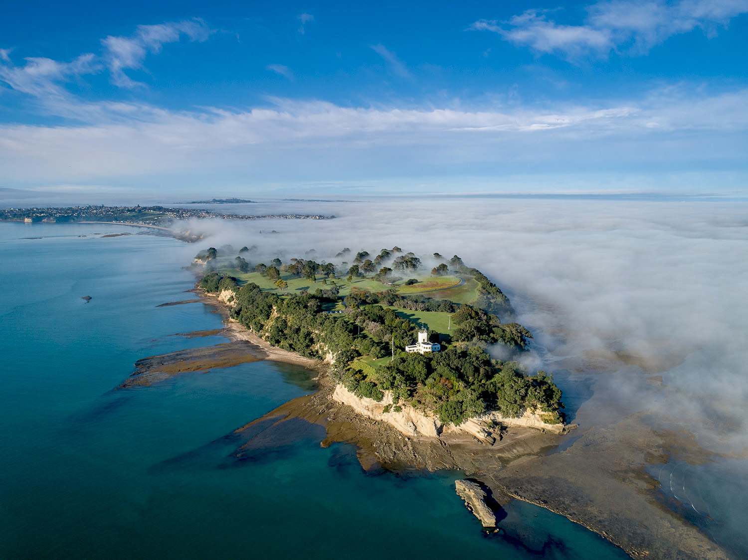
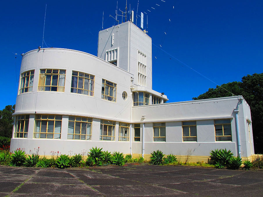
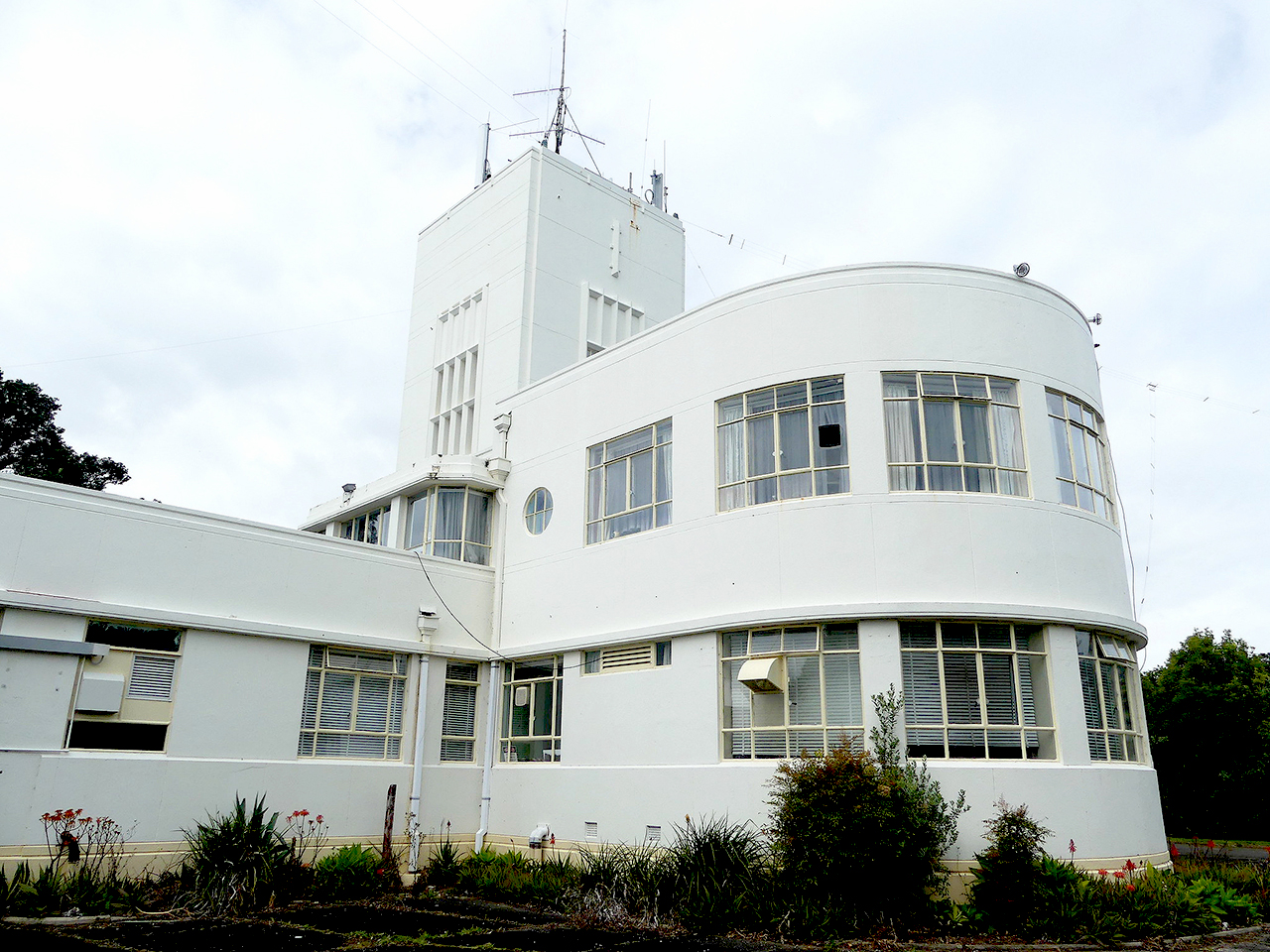
Te Naupata / Musick Point reflects the settlement and use of a strategic promontory of the Hauraki Gulf extending over three quarters of a millennium. Artefacts from the period of first settlement include stone tools that were probably worked on the site. Written and oral traditions outline the ongoing significance of the site to Ngāi Tai and others. During the late 1930s, the site became pivotal in the development of a radio communication service that was linked with the emergence of commercial international aviation in New Zealand. The station played an important role in the South Pacific campaign during the Second World War (1939-45). Initially known as Te Waiarohia o Ngariki, the northern headland is said to have first been occupied by the Ngariki people, descendants of early Polynesian settlers who migrated to New Zealand in circa 1250. Tainui plants, such as those found within the area, are traditionally regarded to have derived from timbers brought from Hawaiiki as part of the Tainui canoe. Te Waiarohia became a fortified site possibly around the seventeenth century, broadly coinciding with the tribal name Ngāi Tai coming into use after the marriage of Te Whatatau to Te Raukohekohe. From Te Raukohekohe descend the Ngāi Tai people of Tāmaki. There is no record in early nineteenth-century accounts of Te Waiarohia being occupied, George Graham having stated that it had become tapu as a result of warfare in 1821. Acquired by the Crown following an investigation into land dealings by the early missionary William Fairburn, the site was used for grazing as late as the 1950s. In the late 1930s, Te Naupata / Musick Point was one of five strategic locations for a national communications network that facilitated the introduction of international air services to New Zealand in 1940. Following the loss of a Pan American Airways' flying boat en route to New Zealand in 1938, the New Zealand government instructed that a planned operations building be designed as a fitting memorial to the American aviation pioneer, Captain Edwin Musick. The design of the new building has been credited to John Blake-Kelly, who later became the first New Zealand-trained Government Architect. Its style represents an early local use of Modern or Functionalist-influenced architecture in Auckland, and was conceived as part of a wider landscape modelled on the appearance of an aeroplane and jet stream that was evidently intended to be viewed from the air. Work on the building commenced in 1940 and was undertaken by Hamilton-based contractor, D.C. Street Construction Limited. The facility was opened by Prime Minister Peter Fraser in January 1942 in the presence of American consular officials. The complex included an associated workers' village accommodating staff required for the 24-hour operation. During the Second World War, Te Naupata / Musick Point was the main communications link with New Zealand forces in the Pacific. It also briefly served as the connection between the United States Naval Command station in Auckland and its Washington headquarters. In 1942, a formal landscape surrounding the installation was set out by horticulturalist Roy Thornton, and was notable for its exclusive use of native species. During the 1950s the southeast part of the headland was developed as a golf course by the Howick Golf Club, consistent with earlier plans for public use of the headland as a park. From 1966 the station building was used solely for regional maritime and emergency radio services, one of its original dual purposes. In 1993 it was decommissioned. Since 1999 the Musick Memorial Radio Station has been occupied by the Suburban Amateur Radio Club and was rededicated by the American Ambassador in 2003. It is now an important archive and repository of radio equipment associated with its original use. Te Naupata / Musick Point has aesthetic significance for its visual design and other qualities. It has archaeological value for incorporating the remains of extensive Māori settlement, and later activity linked with conflict in the Pacific during the Second World War. The area has strong architectural significance as an integrated design of Modern or Functionalist influence by John Blake-Kelly, subsequently the first New Zealand-trained architect to become Government Architect. The area has cultural value for reflecting close links between New Zealand and the United States of America. The area has historical significance for its associations with the Māori occupation of Tāmaki-makau-rau; the provision of radio communication services for maritime and international aeronautical activity; the commemoration of American Pacific aviator Captain Edwin Musick and his crew, killed in 1938; and its important role during the Second World War. The area has social significance for its past connections with a close-knit mid to late twentieth-century working and residential community. The area has strong spiritual significance as a wahi tapu and sacred place for Ngāi Tai and has considerable traditional value for its associations with several important ancestors. The area has high technological value for its use of radio communications, and for the presence of extensive equipment linked to this activity.
Location
List Entry Information
Overview
Detailed List Entry
Status
Listed
List Entry Status
Historic Area
Access
Able to Visit
List Number
9335
Date Entered
6th June 2010
Date of Effect
6th June 2010
City/District Council
Auckland Council
Region
Auckland Council
Extent of List Entry
Extent includes the land described as Lots 1-3 DP 158600 (RTs NA107B/757, NA107B/758, NA95A/727), Allot 408 Parish of Pakuranga (NZ Gazette 1982, p.3711), and Part bed of Hauraki Gulf, North Auckland Land District and the following historic places: Te Naupata, and Musick Memorial Radio Station and Workers' Village. (Refer to map in Appendix 1 in the registration report for further information). The registration includes all structures and their fixtures and fittings, other than the Howick Golf Club Building which is excluded from the registration other than the land beneath it. All plantings are included.. Boundary coordinates: 2680286.36 6480838.53 2680289.19 6480839.86 2680356.22 6480818.66 2680541.45 6481088.83 2680449.53 6481629.12 2680241.29 6482160.03 2679859.41 6482539.89 2679637.22 6482214.43 2679588.44 6481906.77 2679654.10 6481079.45 2679710.80 6480770.26 2679835.35 6480763.69 2679846.21 6480779.46 2679890.11 6480751.38 2679906.13 6480810.83 2679926.56 6480825.64 2679939.16 6480831.58 2679952.79 6480834.48 2679973.47 6480834.72 2679995.83 6480917.53 2680286.36 6480838.53
Legal description
Lots 1-3 DP 158600 (RTs NA107B/757, NA107B/758, NA95A/727), Allot 408 Parish of Pakuranga (NZ Gazette 1982, p.3711) and Part bed of Hauraki Gulf, North Auckland Land District
Cultural Significance
Cultural Significance or Value Te Naupata / Musick Point has cultural value for embodying a variety of connections between New Zealand and the United States of America, including through commemoration of an American citizen, air links between the two countries, and joint participation and cooperation during the Second World War. Social Significance or Value The area has social significance for having functioned as a close-knit working community during the mid to late twentieth century, when many employees lived on the site. The influx of families greatly increased the permanent population of Bucklands Beach prior to more recent development in the suburb. Spiritual Significance or Value The area has strong spiritual significance as a sacred place for Ngai Tai. Burials are known to be present. Ngai Tai consider the place to be wahi tapu. The place is stated by George Graham to have become tapu as a result of inter-tribal conflicts at the beginning of the nineteenth century. Traditional Significance or Value Te Naupata / Musick Point has considerable traditional significance for its associations with several important ancestors of Ngai Tai, including the Ngariki people, members of the Tainui crew, and Te Whatatau and Te Raukohekohe, from whom the Ngai Tai people of Tamaki are descended. The area is considered to have been a stopping point for the Tainui canoe as it accessed the Tamaki portage between the Waitemata and Manukau Harbours. Tainui have traditions associated with this event. Groves of the tainui plant are reported to have been found on the site prior to horticultural activities in the 1940s. Traditional accounts consider tainui plants to have been introduced from timbers brought from Hawaiiki as part of the Tainui canoe.
Historic Significance
Historical Significance or Value Te Naupata / Musick Point is historically significant for its associations with the occupation of Tamaki-makau-rau for an extended period prior to formal colonial arrival in 1840. It is linked with several individuals of note, including important ancestral figures for Ngai Tai. It has links with the early transfer of Maori land to missionaries and the transfer of surplus land from disallowed early land claims as 'waste lands' to the Crown. Used for grazing over an extended period, the area is connected with the development of farming in Auckland's rural hinterland. The area has particular value for its strong connections with the government provision of radio communications infrastructure for maritime services in Auckland and for national aviation services following commencement of a trans-Tasman air service in 1939. It also has particular historical significance for its vital role in the South Pacific campaign during the Second World War as the main communication link with New Zealand forces and with the Coastwatchers headquarters in Fiji. For a time the Musick Point Radio Station served as the communication facility between the United States Naval Command stationed in Auckland and its Washington Headquarters The area also has historical significance for its commemorative connections with the American aviator and pioneer of Pacific air routes, Captain Edwin Musick, and his crew. They and their flying boat disappeared without trace on an inaugural Pan-American commercial flight to New Zealand in 1938.
Physical Significance
Aesthetic Significance or Value Te Naupata / Musick Point has aesthetic significance for its notable visual qualities, including the distinctive appearance of the main Radio Station, the park-like nature of the broader area, and its striking location beside the Hauraki Gulf. The area has strong landmark values, being visible and distinctive when viewed from the Hauraki Gulf and the Tamaki River, from adjacent beaches and suburbs to the east and south, and from the air. The Musick Memorial Radio Station is of visually unusual and striking design and incorporates notable external and internal detailing. Archaeological Significance or Value Te Naupata / Musick Point has considerable archaeological significance as an area that has been the focus of Maori activity since the early settlement of New Zealand. Important remnants include artefacts linked to archaic East Polynesian-period occupation, numerous shell midden indicating settlement throughout the headland, and substantial defences and related activity at the northern end of the area. The area also has archaeological significance as a well-preserved physical landscape connected with conflict in the Pacific during the Second World War. It contains some evidence of early colonial activity. Architectural Significance or Value Te Naupata / Musick Point has strong architectural significance for incorporating the well-preserved remains of an integrated, designed landscape dating to the early 1940s that is influenced by the Modern or Functionalist aesthetic. This includes the Musick Memorial Radio Station, its approaches, gates, plant beds and plantings of native species. The Musick Memorial Radio Station is a notable and distinctive example of Modern or Functionalist design, which strongly reflects the technological purpose for which it was erected. The area also has architectural significance for incorporating an early design by John Blake-Kelly, who went on to become the first New Zealand trained architect to hold the post of Government Architect (1971-3), and the work of Roy Thornton, an important government gardener noted for his use of native plants. Technological Significance or Value Te Naupata / Musick Point has strong technological value for its connections with the development of radio communications from the 1930s onwards. It retains notable remnants of this technology in the fabric of the main Radio Station, its fixtures and fittings, and its associated chattels. It contained purpose-designed ducting within the floors and walls to provide for wiring, perhaps an early technological innovation.
Construction Professional
Biography
Landscape designer and horticulturalist Roy Leslie Thornton (1893-1969) was appointed to the New Zealand Railways Department in 1934 and subsequently became head gardener for the Department's Auckland district. Part of Thornton’s early experience had been gained some at the nurseries of Messrs D. Hay and Sons, where he was head propagator, and later became manager. Credited with the laying-out some of the larger private gardens in the Auckland suburbs of Epsom and Remuera, he was involved in the development of the grounds of Middlemore Hospital site, of Avondale College, and the Mount Smart Domain. While Auckland’s head gardener for the Railways, his skills were utilised to develop the windswept five-hectare site of the Musick Memorial Radio Station. Native trees and shrubs formed a Memorial Plantation made in 1942 to commemorate American aviator Captain Edwin Musick and his crew who died in a 1938 air accident. The exclusive use of native plants for this project reflected Thornton’s own expertise and interest, and developments in the use of New Zealand flora in designed landscapes. (Matthew Felgate, Martin Jones and Joan McKenzie, Te Naupata / Musick Point Registration Report, 17 May 2010, NZHPT).
Name
Thornton, Roy
Type
Designer
Biography
No biography is currently available for this construction professional
Name
D.C. Street Construction
Type
Builder
Biography
No biography is currently available for this construction professional
Name
Public Works Department
Type
Builder
Biography
No biography is currently available for this construction professional
Name
Public Works Department
Type
Architect
Biography
No biography is currently available for this construction professional
Name
Public Works Department
Type
Architect
Biography
No biography is currently available for this construction professional
Name
Public Works Department
Type
Builder
Biography
John Thomas Mair (1876-1959) was born in Invercargill and began his career with the New Zealand Railways on the staff of the Office Engineer, George Troup. In 1906 he travelled to the United States of America where he studied architecture at the University of Pennsylvania. He then worked in the office of George B. Post in New York before travelling to England where he was admitted as an Associate of the Royal Institute of British Architects. He became a Fellow in 1940. On his return to New Zealand he entered private practice, one of his first buildings being the Presbyterian First Church, Invercargill (1915), a prominent building of Romanesque character. He then practised in Wellington, carrying out largely domestic commissions. In 1918 he was appointed Inspector of Military Hospitals by the Defence Department, and in 1920 he became architect to the Department of Education. Following the retirement of John Campbell in 1922, Mair was appointed Government Architect, a position which he held until his retirement in 1942. During this period he was responsible for a variety of buildings, including the Courthouse, Hamilton, the Post Office in High Street, Christchurch, Government Life Office and the Departmental Building, both in Wellington, and the Jean Batten Building, Auckland. Such buildings show a departure from tradition, with the emphasis on function, structure and volume as opposed to a stylistic treatment of the building fabric. A Fellow of the New Zealand Institute of Architects, Mair was made a Life Member in 1942. His son John Lindsay Mair also practised as an architect.
Name
Mair, John Thomas
Type
Architect
Biography
John Blake-Kelly was Government Architect from December 1971 until his retirement in June 1973. Prior to this he had had a long career as an architect in the Public Works Department, (later known as the Ministry of Works). Blake-Kelly was born in Auckland in 1913. Upon graduating Bachelor of Architecture from the Auckland University in 1937, he joined the Public Works Department as a draughtsman in the Auckland office. It was in this capacity that he designed the Mount Albert Telephone Exchange, New North Road (1941) and the Musick Memorial Radio Station at Howick, (1941). At about this time also, his designs were awarded third place in competitions for Auckland's Anglican Cathedral and the Michael Joseph Savage Memorial. After the Second World War, in which he served in the Royal Navy, Blake-Kelly was posted to the new position of sectional architect in Wellington. Here he was involved in the development of post-primary schools (built as Taita and Mana College). These came to be used as a national standard. In 1952 Blake-Kelly was appointed District Architect, Wellington, where he was involved in Government projects from Gisborne to Nelson and Marlborough. During this period he was involved in the development of fair-faced concrete. Seven years later he was appointed Assistant Government Architect, responsible to the Government Architect for design and construction of Government works including projects of considerable magnitude such as the science schools for Canterbury, Massey and Auckland Universities. He was also closely associated with the design of Auckland's Paremoremo Maximum Security Prison (1969) and, as chairman of the Planning Executive Committee, was responsible for design direction of the Auckland International Airport Terminal Buildings (1971).
Name
Blake-Kelly, John Robert
Type
Architect
Construction Details
Description
Archaic period occupation
Finish Year
1300
Start Year
1250
Type
Original Construction
Description
Fortification of earlier settlement?
Type
Original Construction
Description
Road
Start Year
1938
Type
Original Construction
Description
Cottage, shed, power substation; aerials and masts for temporary radio station facility
Finish Year
1939
Start Year
1938
Type
Original Construction
Description
Public works camp including two-man huts and Workers' village (including water tower).
Finish Year
1940
Start Year
1939
Type
Original Construction
Description
Musick Memorial Radio Station, planters, plinths, formal drive, pylon gates with flagstaffs.
Finish Year
1941
Start Year
1939
Type
Original Construction
Description
Concrete anchor block on foreshore to secure submarine nets.
Start Year
1941
Type
Original Construction
Description
Emergency radio bunker; three air raid shelters; establishment of the Memorial Plantation landscaping.
Start Year
1942
Type
Original Construction
Description
Hostel (two-storey) (annex added 1947 destroyed 1948).
Period
Early 1940s
Type
Original Construction
Description
Tennis court at workers' village
Period
Mid-1940s
Type
Original Construction
Description
Four-unit block of flats
Start Year
1948
Type
Original Construction
Description
Former post office building transported to site and reused as three-unit block of flats.
Start Year
1949
Type
Relocation
Description
Development of golf course, Howick Golf Club.
Start Year
1953
Type
Original Construction
Description
Commemorative plaques donated by Mrs Musick.
Start Year
1954
Type
Addition
Description
Building moved onto the site for use as a club house (golf course).
Start Year
1955
Type
Relocation
Description
Greenkeeper's house (golf course)
Type
Original Construction
Description
Houses for Civil Aviation staff, as extension of workers' village.
Period
1960s
Type
Original Construction
Description
Demolition of hostel
Start Year
1964
Type
Demolished - Other
Description
Workshop and implement shed (golf course)
Period
Late 1960s
Type
Original Construction
Description
Club house replaced by new building, professional and junior's shed constructed (golf course).
Finish Year
1977
Start Year
1976
Type
Original Construction
Description
Demolition: Water tower
Start Year
1985
Type
Demolished - Other
Construction Materials
Reinforced concrete, plaster finish
Notable Features
Memorial Hall including plaster work, terrazzo floor and bronze plaques Flush panel doors with porthole windows (interior) Main entrance including doors, fittings, lettering and fenestration. Entrance gates (concrete pylons surmounted by flag poles) Formal landscaped driveway and grounds in the immediate environs of the buildings.
Early history of the site The early history of Te Naupata / Musick Point is reflected partly in the archaeological landscape, and more richly in written and oral traditions. Initially known as Te Waiarohia o Ngariki, the northern part of the headland is said to have first been occupied by the Ngariki people, descendants of early east Polynesian settlers who migrated to New Zealand in circa 1250 AD prior to the arrival of the Tainui and Arawa canoes. Artefacts linked with early settlement in the area include flakes and other objects that are connected with the creation of stone tools. More concentrated areas of finds to the south of the area indicate that early settlement extended over other parts of the peninsula. Archaic-period sites are comparatively rare in the Auckland isthmus in relation to later activity, although contemporaneous early material has also been found on nearby Motukorea / Browns Island and other islands in the Hauraki Gulf. Sites from this period reflect a marine-based society, which frequently settled coastal land close to river or harbour mouths. Groves of the tainui plant (Pomaderris apetala) are reported to have been found at Te Naupata prior to more recent possible plantings of the species on the site. Botanical perspectives have noted that such trees are not endemically native and may be sourced to Australia. Traditional accounts, however, consider tainui plants to have been introduced from timbers brought from Hawaiiki as part of the Tainui canoe. The Tainui canoe is traditionally regarded to have spent some time at Tamaki prior to being dragged across the Otahuhu portage to the Manukau Harbour. Two members of the Tainui crew (Te Keteananataua and his son Taihaua) remained with the local people. Two more of the crew (Rakataura and Taikehu) elected to stay at Manukau. Ngai Tai believe that their ancestors Taihaua and Taikehu, as well as the name of the waka Tainui are reflected in the name Ngai Tai, which was adopted at a later date. The descendants of Taikehu became numerous in the area. Nga waka o Taikehu, me he kahui kataha kapi tai. The canoes of Taikehu like unto a shoal of herrings filling the sea. The archaeological record demonstrates that kumara storage places and tuangi shell midden were densely distributed across the landscape in the early seventeenth century, with signs of heavy exploitation of marine resources. In the late sixteenth century Hotunui, and shortly after, his son, Marutuahu, migrated to the Hauraki area to the east of Ngai Tai. In the mid seventeenth century Paoa also migrated from the Waikato. Ngati Paoa expanded in numbers in the following centuries, both in the inner Hauraki Gulf Islands and in Tamaki. Ngai Tai o Tamaki Occupation at Te Waiarohia seems highly likely during this period, confirmed by traditions concerning Te Whatatau who was resident at his homes on the Wairoa and at Tamaki, most likely including Te Waiarohia. A group from Torere, in the Bay of Plenty/East Cape area, also of Tainui descent, migrated to the Wairoa area following the marriages of Te Whatatau to Te Raukohekohe and Motu Ki Tawhiti, granddaughter of the Torere Rangatira Tamatea Toki Nui. From Te Raukohekohe descend the Ngai Tai people of Tamaki. It is at this time that the tribal name Ngai Tai came into use. Te Whatatau's son Te Wana was a noted military leader and cemented the Ngai Tai territorial limits by conquest. By the beginning of the eighteenth century, Hua Kaiwaka came to control the Tamaki Isthmus and surrounding districts through a confederation of Tainui peoples, including Ngai Tai, that became known as Waiohua. Ngai Tai became known as the Ngati Kohua hapu of Waiohua, occupying the area from Te Naupata to Tapapakanga (the latter on the Firth of Thames). In this period, Te Naupata would have been important as Ngai Tai's territorial boundary to the west. It is likely that some of the fortifications of Te Waiarohia are of eighteenth-century date, by which time they may have been known as Te Waiarohia o Ngai Tai Pa. Tara Te Irirangi was a noted leader of Ngai Tai at the time of early European contacts, and was the great grandson of Te Wana. Early European accounts emphasise the extensive cultivations and material wealth of Ngai Tai and Ngati Paoa at this time. The inner Gulf had been a provisioning place for whalers since the 1790s. There is no record in early nineteenth-century accounts of Te Waiarohia being occupied. Possibly before 1820, when the northern tribes armed themselves with muskets, major changes again occurred in patterns of habitation. On the Tamaki River, settlement was focussed around Mokoia Pa and the trading village of Mauinaina, with an extensive and dense distribution of settlements and gardens upstream from these places and into the Manukau. Produce could purchase muskets, a key to survival even into the 1830s. The remainder of the local landscape appears to have been virtually deserted. Although settlements in the Maraetai and Wairoa area were initially spared from Ngapuhi attack in 1821 on the orders of Patuone, who shared Arawa descent with Ngai Tai, Te Tirarau led a Parawhau war party to attack the Wairoa settlements at about this time, a period when Tara Te Irirangi was away procuring muskets. George Graham stated that Te Rangi Tauhia was the last chief of Te Waiarohia from about 1790 until circa 1821, and that the Pa became tapu as a result of the warfare. These substantial changes were compounded by the effects of European diseases, and the population of the Ngai Tai rohe was decimated between 1820 and 1830. Burials are known on the site. By the 1830s a measure of security was returning to the area - Patuone, a Ngapuhi Rangatira, moved south to reside at Waiheke, and a peace agreement was reached on the western shore of the Tamaki River in 1836, attended by Te Wherowhero amongst others. The missionary William Fairburn purchased a vast tract of land between the Tamaki River and the Wairoa, in order to aid the peace process and to secure the land from competing claims. A mission station was established at Maraetai, but there is no record of Te Waiarohia being reoccupied. Fairburn later said that no Maori were living in this area at the time of the purchase, and that his claim provided a buffer zone in the maintenance of peace. The area eastwards from Maraetai continued to be thinly populated, with inhabitants concentrated in comparatively large settlements for security. In 1838 further warfare and an influenza epidemic halted a fragile recovery of the population. After the establishment of Auckland as colonial capital in 1840, many Ngai Tai moved to that settlement to take advantage of better wages. Large-scale cultivations in the Wairoa area supplied produce to the growing Auckland market. In the early 1850s, the Crown made limited payments to several groups in relation to Fairburn's holding, evidently in an attempt to persuade them to relinquish their claims on the land. Crown acquisition and colonial farming In 1854, the Crown 'resumed wasteland' from Fairburn's Claim, including Te Naupata (Allotment 56). Ngai Tai resided on reserved Land at Umupuia, and at this time are said to have numbered less than a hundred people. Allotment 57, to the south of Te Naupata, remained in Fairburn's ownership until its sale in 1851 to architect William Mason (1810-1897), New Zealand's first Superintendent of Public Works. Mason's East Head farm, on which he built a timber homestead (demolished in the 1950s), was purchased in 1861 by livestock auctioneer Alfred Buckland (1825-1903), reputedly the largest agriculturalist in the province. In 1869, Te Naupata was reserved for the purposes of primary education. An 1873 lease application by Buckland may have been a continuation of grazing of the land in conjunction with East Head Farm. In 1899-1900 the Bank of New Zealand Realisation Board, briefly the managers of the Buckland farm, unsuccessfully sought Board of Education approval to form road access on the headland. The terms of a 1908 lease granted to Panmure settler Edwin Gollan stipulated that he could not cut, fell, clear or carry away any timber on the education reserve site for cultivation and fencing. Gollan was also required to root up all gorse, briar, bramble and other noxious weeds. By the early 1900s, the adjoining area of Bucklands Beach had become a popular destination for day excursions from Auckland, with seaside subdivisions being undertaken in 1916 and 1923. Captain Musick and the Musick Memorial Radio Station During the late 1930s, the landscape at Te Naupata was radically transformed by the construction of a radio facility. The first coastal radio stations in New Zealand had been created at Wellington (1911), Auckland (1912) and several other locations (1913) in response to radio's military and maritime potential. Shipping services remained the most important use for radio in New Zealand until 1923 and the commencement of public radio broadcasting. Radio was also important for communicating with New Zealand's offshore islands. Advances in air transport occurred at a similar time. Against a background of expanding commercial international flight routes, Pan-American Airways' Chief Pilot, Captain Edwin Musick (1894-1938) and his crew landed a Sikorsky flying boat - the Samoan Clipper - at Auckland's Mechanics Bay on 30 March 1937 as part of the investigation of an air route across the South Pacific. The event highlighted the possibility of mail and passenger air services and their potential to reduce New Zealand's geographical isolation. Tasman Empire Airways Limited (TEAL) was established by the New Zealand, Australian and British governments in the same year to service a trans-Tasman link. Planning began for a purpose-built combined facility that would accommodate 24-hour regional maritime and emergency radio services, and aeronautical radio communications for international air services to New Zealand. This was closely coordinated with the construction of a flying boat base at Mechanics Bay on the fringe of the central business district, a facility that was effectively Auckland's international airport for many years. The search for a site that was sufficiently removed from electrical interference culminated in negotiations to acquire approximately 50 hectares of Te Naupata headland for a radio receiving station. A further eight hectares was obtained five kilometres away at Oliver Road for an associated transmitting facility. While planning was in progress, an Imperial Airways flying boat surveying the air route from England to New Zealand via Sydney, and Captain Musick's craft on a second survey flight to New Zealand, arrived at Auckland on Boxing Day in 1937. The Prime Ministerial welcome accorded by Michael Joseph Savage (1872-1940) reflected the perceived economic benefits of the projected services. It was anticipated that these would provide for international business and tourist travel, and faster mail. In January 1938 the Samoan Clipper crashed on its first commercial flight to New Zealand, killing Captain Musick and his crew. Reflecting the public's sense of loss at the death of the prominent American aviator, the New Zealand government instructed that the proposed radio receiving station at Te Naupata be designed as a memorial building and that the site be renamed Musick Point. Design and initial construction of the Musick Point complex (1938-40) The new facility at Musick Point was planned to include a receiving station, staff quarters and radio plant. Detailed designs were developed in early 1938 to meet radio and meteorological requirements for the commencement of a proposed trans-Tasman air service. Important functions for the complex included the provision of two-way communication with aircraft during flights, communication with overseas air terminals, and the receiving of meteorological information. Designs envisaged a formal layout for the receiving station, with a driveway and gardens leading up to it. Radio masts formed part of the symmetrically planned concept. As a facility associated with international air services and as a memorial to the American aviators, consideration was evidently given to an appropriate design for the station and its landscape, including its visual form from the air. The design was undertaken by the Public Works Department under Government Architect John Thomas Mair, with John Blake-Kelly (1913-88) as the project architect. Blake-Kelly was later to become Assistant Government Architect in 1959, and the first New Zealand graduate to be appointed Government Architect, in 1971. In 1938 preparatory earthworks damaged Te Waiarohia pa, a place that had retained its importance to tangata whenua. Te Akarana Maori Association and other groups communicated their concerns to the Minister of Works, Robert Semple. In conjunction with the Auckland Historical Society, the Association suggested that a waharoa or Maori carved gateway with palisades be erected along the line of the damaged ditch and bank to form the entrance to the radio station grounds. These proposals were not pursued to completion. As part of the initial works, a purpose-built access road was constructed along the length of the headland. A comprehensive system of masts and aerials occupied various locations, and a small power sub-station was erected near the earlier ditch and bank. A temporary radio station was established in two minor buildings later incorporated into the residential village as a cottage and a gardener's shed, and was ready for operation in August 1939. The station's foundation staff comprised a superintendent, a supervisor, three operators and a technician. A residential village of houses to the standard Post Office design was constructed in 1938-9 adjoining the west side of the carriageway inside the main entrance. This accommodated staff required to operate the radio station 24 hours a day. Located at some distance from the proposed receiving station to minimise radio interference, the village may have been built on the site of an earlier bach. The timber dwellings, built for married personnel and supervisors, had varied detailing and were laid out in a 'garden suburb' style, offset rather than in formal rows. The largest house, for the superintendent, was located on a slight rise. A water tower and, later, a hostel formed part of the village complex. The influx of families greatly increased the permanent population of Bucklands Beach. Construction of the Musick Memorial Radio Station building (1940-42) The Musick Memorial Radio Station building was erected during a period of limited overall construction activity due to commitment of resources to the war effort. Tenders for the reinforced concrete building were called on 8 July 1940, a contract won by the Hamilton-based D.C. Street Construction Limited. Construction may have been supervised by Tibor Donner (1907-93), a notable architect in charge of the Architectural Design Office of the Public Works Department. Donner was the designer of the associated Oliver Road radio transmitting building. The design for the main receiving station adopted elements of Modern or Functionalist style, a genre favoured internationally for buildings associated with new technology, including those linked with transport and communications. Prior to the Second World War (1939-45) few buildings in New Zealand reflected the developing theories of the Modern Movement, which grew out of European experimentation during and after the First World War (1914-18). The Musick Point structure was of a transitional architectural design, incorporating traditional symmetrically arranged axial planning and a modern external appearance with streamlined Art Deco detailing. The building's exterior form was said to represent the shape of an aeroplane, with formal linear gardens linking to an entrance gate giving the impression of a jet stream or runway. The memorial function of the building was emphasised by a central tower reminiscent of a cenotaph, while flanking single-storey wings resembled those of an aeroplane in flight. A semi-circular two-storey bay, with generous windows overlooking the Hauraki Gulf, represented the nose of the aircraft. Internally, the main entrance of the building opened into a memorial hall, which had a relief panel portraying an American eagle on two of its side walls. Staff quarters in the west wing consisted of a living room, kitchen, bathroom and sleeping quarters. Accommodation in the east wing included a riggers' room containing radio lines that provided telephone services to the Hauraki Gulf Islands. Adjacent to the main lobby was the superintendent's office. Operations rooms on both floors looked seawards. The operations rooms had purpose-designed ducting within the floors and walls to provide for wiring, perhaps an early technological innovation. The facility was opened by the Prime Minister, Peter Fraser (1884-1950) in January 1942. A memorial plaque in the entrance hall commemorated Edwin Musick. The ceremony was attended by consular representatives from the United States of America (USA). The Prime Minister's speech stressed the bonds between that country, Britain and New Zealand, and co-operation in the war effort. The station was equipped to handle aeronautical radio communications via the air base at Mechanics Bay, and also took over the regional maritime and emergency services performed by a station that had been located in the Chief Post Office since 1912. TEAL had commenced regular air services between Auckland and Sydney in April 1940, and Pan-American Airways services commenced between San Francisco and Auckland in September of the same year. Ongoing development in the 1940s Musick Point Radio Station played an important role in the South Pacific campaign during the Second World War. The facility was the main communication link with New Zealand forces in the Pacific, and with the Coastwatchers headquarters in Fiji which was in contact with the various units. Eight New Zealand Post Office radio operators stationed at Kiribati were captured and killed by Japanese troops. Their names were subsequently displayed on a Roll of Honour inside the Radio Station building. High-Frequency direction-finding equipment installed at Musick Point and at Awarua in Southland in 1939 helped to locate the sources of signals emanating from enemy vessels, aircraft and ground units by matching them with cross bearings taken by other stations in the British Admiralty's empire. Following the United States' entry into the war, Musick Point briefly provided the communication link between the United States Naval Command stationed in Auckland with its Washington Headquarters. The American forces introduced their own equipment. In 1942, at the height of New Zealand's fear of attack following February air raids by the Japanese forces at Darwin, Australia, a concrete emergency radio bunker was constructed outside the earlier pa defences. This facility was intended to provide protection for radio equipment in the event of the main radio station building being put out of action. However, no equipment was ever installed. On the foreshore below the headland, a large concrete anchor block was installed to hold submarine nets that extended from the point to nearby Motukorea / Browns Island. During the Second World War, the staff at Musick Point numbered approximately 120, including technicians. An increase in numbers resulted in the construction of a larger, two-storey hostel in the workers' village which included accommodation for female domestic staff. Access to the site was controlled by military personnel. Servicemen stationed to secure access to Musick Point planted four Phoenix palms near the entrance to the site, to remember servicemen who lost their lives during the war. A formal landscape around the receiving station had been part of the initial design concept, including concrete paths, planters and plinths, a straight driveway, entrance gates and planted beds. Following the formal opening of the facility, the services of Roy Thornton (1893-1969), the Head Gardener for the Railways Department in Auckland, had been obtained. The landscape was further developed by 1942 with a more intensive planting of the five hectare area north of a picket fence adjoining the pa defences. Other developments included the ‘Memorial Plantation', which comprised rows of trees parallel to the main drive and grassed areas flanked by clumps of other native trees. Undertaken in September 1942, this planting was extensive in the context of wartime restrictions. The 44 species of native plants were specifically selected for their wind resistant qualities and to prevent interference with radio reception. Reference to Maori place names and traditions may have occurred through the employment of tainui trees (Pomaderris apetala) and taupata or naupata plants (Coprosma repens). The exclusive use of New Zealand native plants reflected Thornton's expertise, and developments in the use of New Zealand flora in designed landscapes. In 1945 a proposal was discussed by local government interests for the creation of a large park within the southeast portion of the headland. However, a ‘rolling lease' continued, with grazing rights to some 10 hectares being granted in 1948. The Post-War period A steady increase in communication services for aviation resulted in the allocation of the upper floor of the Musick Memorial Radio Station to Civil Aviation in 1952. The New Zealand Post Office continued to operate regional maritime and emergency radio services from the ground floor. In March 1954, two memorial plaques donated by Musick's widow were presented at a ceremony attended by dignitaries, including the USA Consul. Mrs Musick paid her first visit to the station during the summer of 1963-4. Steps for the conversion of the southeast portion of the headland into a golf course began in 1953 following negotiations between the Howick Golf Club (formed in 1934) and the Crown. The proposal was consistent with requirements to maintain open space near the radio station and was compatible with late 1930s concepts for use of the site as a public park. The course opened on the new site in 1954, commencing four years of extensive earthworks and an extended programme of tree planting. During the 1960s, the residential village was expanded to accommodate Civil Aviation staff working at the radio station. A small number of additional houses were erected on the east side of the main access road, a short distance to the north of the earlier settlement. In 1964, the hostel in the village was demolished. Civil Aviation staff moved to Mangere Airport in 1965-6, where long range high frequency radio communications with overseas aircraft had operated since 1957. Expanding rapidly, facilities at the golf club included a new clubhouse erected in 1976. On the west side of the peninsula, land associated with nearby finds of an early date was set aside as Te Naupata Recreation Reserve. The setting of land apart for Post Office Purposes in 1976, later led Telecom during its transformation from a State Owned Enterprise to a private company in 1989 to give thought to Musick Point's development potential. A major protest included concerns by Ngai Tai relating to the tapu status of the headland, and a 1200-signature petition by the wider community objecting to the underlying residential zoning of the land. Five claims were lodged with the Waitangi Tribunal in respect of Musick Point in 1992, the main claimants being Ngai Tai, Ngati Paoa and Ngati Whatua. Musick Point was again under Crown control by mid 1993, with Telecom as lessee. The maritime and emergency radio communications services run from the building since 1942 were decommissioned in September 1993. Six years later the Suburban Amateur Radio Club moved into the building, and commenced cataloguing and restoring vintage equipment. Much of the equipment had been used at the station, although some was salvaged from the contemporary transmitting station at Oliver Road, a building demolished in 1995. In 2002, the Musick Point Preservation Society was created with the aim of saving and restoring the building, and ensuring continued public access to the headland. Later known as the Musick Point Trust, the body consisted of representatives of local community groups and wider interests including the Art Deco Society Auckland, and the Institute of Professional Engineers of New Zealand's National Committee for Engineering Heritage. The latter organisation erected a plaque in 2002 to commemorate the Radio Station's important place in New Zealand's engineering history on a number of grounds including for its long association with radio communications, the opening up of Pacific air routes, and its special significance during the Second World War. The Musick Memorial Radio Station building was rededicated by the American Ambassador on 12 January 2003, on the sixty-fifth anniversary of the loss of the Pan Am Sikorsky flying boat and crew. The structure remains in use as a radio station and contains archives and an important collection of radio equipment. Houses in the workers' village are still occupied as residences. The broader golf course, headland and foreshore remain in use as popular places of leisure and recreation.
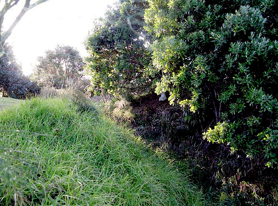
Context Te Naupata / Musick Point is located on the south shore of the Hauraki Gulf, in the Bucklands Beach locality of the eastern suburbs of Auckland. As the headland of the Tamaki Peninsula, the point commands a panoramic view of the Waitamata Harbour and Hauraki Gulf, the coast to the south, and across the Tamaki River to the west. In earlier times the headland was a strategic position for the control of access to the Tamaki River portage, which led to the Manukau Harbour on New Zealand's west coast. Located two kilometres to the north of Te Naupata is Motukorea / Browns Island, a similarly strategic location which is said to show evidence of at least 300 small pre-colonial settlements. The Gulf islands including Waiheke and Great Barrier were part of an extensive coastal trade network that extended to the Coromandel Peninsula and beyond. The intensive occupation of the region prior to 1840 is evidenced by the high density of archaeological sites in the wider area which include fortified pa, pit and terrace configurations and middens. Te Naupata / Musick Point is also a strategic element within a network of more recent military coastal defence sites (notable nineteenth-century representatives of which are Fort Takapuna, North Head and Fort Bastion); while sites including batteries at Castor Bay, Rangitoto, Motutapu, Motuihe and Waiheke's Stony Batter are twentieth century installations. The Functionalist-influenced building and landscape commemorating Edwin Musick is one of two memorials constructed on southern promontories overlooking the Hauraki Gulf. The other, the Savage Memorial on Bastion Point - a promontory located to the west further up the harbour - commemorates New Zealand's first Labour Prime Minister Michael Joseph Savage (1872-1940). General description and layout The main axis of Te Naupata / Musick Point runs north-south. For most of its length, its seaward sides are bounded by tall cliffs. The exception is at Te Naupata Reserve in the southwest corner of the site, where there is direct access to the foreshore. The boundaries of the place extend into the Hauraki Gulf to encompass large areas of rock shelf that are exposed at low tide. The area can be divided into five elements: i) the esplanade reserve, foreshore and seabed; ii) the pa at the northern end of the headland; iii) the Radio Station, its formal surrounds and associated structures; iv) land flanking the approach road on the western side of the headland, including residential workers' housing; and v) the golf course, largely occupying the central and eastern part of the headland. i) Esplanade reserve, foreshore and seabed Te Naupata Reserve lies in the southwest corner of the site, with a nearby distribution of flaked tools, adzes and sinkers indicating that an early workshop site is located in the close vicinity. Other early artefacts - including files, obsidian and unfinished adzes - have been found on the foreshore a short distance to the north. Hand-moulded bottles are items with colonial or immediately pre-colonial connections. At low tide expanses of flat, rock shelves extend from the headland, in fingers and reefs out to sea. The site traditionally afforded a variety of sheltered anchorages and hauling out platforms for canoes in a variety of winds and tidal conditions. Ballast stones have been identified offshore at two locations, one on either side of the peninsula headland. Two large greywacke boulders on the western foreshore have been sourced to Motutapu, located some distance to the north of Motukorea / Brown's Island in the Hauraki Gulf. Steep cliffs rising above the foreshore were natural defences, with easily guarded clefts providing access down to the sea. On the foreshore below the headland a concrete anchor stone is visual evidence of the strategically located submarine nets stretched between Te Naupata and Motukorea / Browns Island as part of military coastal defences established during the Second World War. ii) Pa at the northern end of the headland Te Waiorohia Pa occupies a large area at the northern end of the headland, protected by steep cliffs. It commands extensive views out towards Motukorea / Browns Island and beyond. Archaeological features associated with the pa are indicated in a 1941 plan of the site, which was based on earlier observations. These may primarily reflect activities linked with circa eighteenth-century occupation of the site. A large ditch and bank indicated on the plan remains a substantial feature, strategically separating the headland from the peninsula. It has been partly modified by the creation of an access road between the northern end of headland and Bucklands Beach. Internally, the eastern part of the pa contained a number of intermittent pits clustered in groups, some of which are still visible. A well-defined terrace on the same side overlooks the Hauraki Gulf. The western part of the interior contained pits, whare sites and shell midden, which are now less visible. Midden was also identified in association with a cooking site on the flat area of the headland. Areas of exposed shell can be seen at the northern end of the site. A west-facing terrace offered views over the Tamaki River. The latter formed the gateway to an important portage between the Hauraki Gulf and the Manukau Harbour. Much of the area occupied by the pa is now grassed over. iii) Radio Station, its formal surrounds and associated structures The Musick Memorial Radio Station and its designed landscape is a single visual entity that occupies part of the interior of the pa site. It is reached via an access road that terminates at a gateway signalling a formal entry to the memorial area. The gate, a symbolic rather than physical boundary, consists of two narrow concrete plinths bearing flag poles. A linear driveway connecting the gateway and the Memorial Radio Station is flanked by footpaths and concrete bollards, reinforcing the formality of the space. An avenue of well-established native trees visually narrows the driveway and draws the focus to the central tower of the memorial. The reinforced concrete Radio Station building is a well-preserved structure with a plaster finish. It is of Modern or Functionalist design, of which there are comparatively few examples in Auckland. The structure incorporates a prominent central tower, flanking single-storey wings, and a two-storey northern bay with a sharply curved façade. It occupies the centre of a hard-paved court which incorporates a semi-circular arc on its northern side, echoing the curve of the northern bay of the building. The main entrance to the Radio Station is located in the south façade of the tower, and is reached by a set of shallow steps flanked by large concrete planters. Art Deco-style decorative elements include elegant rectangular lights around the entrance, and integrated lettering outlining the words 'Musick Memorial' above the main door. Secondary doorways provide an alternative means of access at the end of the west wing and in the north elevation of the east wing. Prominent, metal-framed windows in the central tower are deeper-set than elsewhere in the building. Internally, the Musick Memorial Radio Station is extremely well-preserved. At ground floor level the structure incorporates a central memorial hall, which forms the focal space of the building. The hall is a simple but dignified area, which has two wall panels on which eagles are depicted. It also has a terrazzo floor, and plaques commemorating the American aviator Captain Edwin Musick and his crew. The space provides access to an operation room in the north bay of the building, to long corridors in the east and west wings, and to a staircase to the first floor. Rooms in the west wing mostly consist of accommodation, including a bedroom with original fitted furniture that incorporates a bed and a wardrobe. A kitchen at the western end of the wing has well-preserved fittings and fixtures including a meat safe. Rooms in the east wing are more connected with the technological function of the building and currently include a large workshop. An operation room is located in the north-facing part of the building overlooking the Hauraki Gulf, and has large curved windows. It incorporates recessed ducts for holding cables associated with the early use of the structure. Decorative features at ground floor level include elegant ventilation grilles in the ceilings. The first floor was previously taken up with a single large space that has since been partitioned using screens with glass windows. A smaller room to the southeast contains a heavy metal safe and a tall wall clock, which are early elements. Access to the flat roofs of each wing is provided at first floor level. The roofs are bounded by low parapet walls. A further staircase leads to small rooms in the tower, which include a space currently used as a kitchen. The building currently contains significant equipment associated with the early use of the building. Associated features in the grounds include concrete foundations for an aerial, mast or direction finder to the west of the main gate. A power substation structure is located nearby, consisting of a small timber building with corrugated metal, hipped roof. This is believed to be the earliest surviving building associated with radio communications on the site. iv) Land flanking the approach road on the western side of the headland, including residential workers' housing The access road connecting the radio station with Bucklands Beach is a well-preserved part of the original design concept. Just outside the bank and ditch, and to the east of the road, there is an underground emergency radio station (1942). This consists of a small, rectangular concrete structure, of which the upper portion and entrance are externally visible. Approximately a quarter of the way from the radio station to Musick Point Road, there is a sharp bend in the road. A number of masts and aerials were once located to the east of the bend. Located above Te Naupata Reserve on the west side of the road is the oldest surviving section of the workers' village. The cluster of timber houses with tiled roofs is informally arranged along a winding driveway that doubles back in a similar direction to the main access. As some of the oldest surviving buildings on the site (1937-8) these have historical significance apart from their qualities as Public Works Department-designed houses of the time. Some have accessory buildings, paths, fences and plantings that are suggestive of that era. Further to the north on the opposite side of the road is a collection of 1960s-era government housing that forms an extension to the earlier village. While there are similarities in the overall building design, construction and materials, some of the latter structures have a greater emphasis on window apertures. These buildings are also more regimented in their siting than the 1937-8 dwellings. The more fluid arrangement of the 1930s-era houses reflects garden city design influences that were popular at the time. v) Golf course, occupying the central and eastern part of the headland The land occupied by the golf course has been affected by substantial landscaping. However, areas of possible shell midden have been noted in several places where cut through by later works. Landscaping may have buried some deposits as well as removing others. The current landscape consists of large fairways lined with trees planted in the 1950s. Ponds have been created in some places. A large clubhouse and car park exist in the southeast part of the area. Land included in the Registration The land included in the registration comprises the northern headland of Te Naupata and adjoining parts of the foreshore and seabed. It encompasses all land associated with pre-colonial Maori occupation and activity at the northern end of the peninsula, and all land subsequently owned and occupied by the Crown for the creation and functioning of the Musick Memorial Radio Station and its associated workers' accommodation. Historic Places on Land included in the Registration Te Naupata Musick Memorial Radio Station and Workers' Village Relationship between Historic Places The boundaries of the historic places are broadly identical to each other and to the collective boundary of the historic area. Construction Materials Concrete (Musick Memorial Radio Station, emergency radio bunker, anchor block for submarine nets, radio mast bases) Timber, with corrugated metal roof (Power sub-station) Timber, concrete-tile roof (Houses)
Public NZAA Number
R11/1824
Completion Date
6th June 2010
Report Written By
M. Felgate, M. Jones, J. McKenzie
Information Sources
Gatley, 2008
Christine McCarthy, ‘Hannah Playhouse (also known as Downstage)’Julia Gatley (ed.), Long Live the Modern: New Zealand's New Architecture 1904-1984, Auckland University Press, Auckland, 2008
Murdoch, 1996
Graeme Murdoch, A History of the Human Occupation of the Whakakaiwhara Block', Auckland, 1996
Fairfield, 1995
Geoff Fairfield, Te Waiarohia o Ngaitai: The Story of the Bucklands Beach Peninsula, Auckland, 1995
Baquie, 2006
Barry Baquie and Rod Clough, 'Te Waiarohia Pa (R11/23), Musick, (Te Naupata) Point: Archaeological Report', Auckland, 2006
Conservation Plan
Conservation Plan
Report Written By
A fully referenced registration report is available from the NZHPT Northern Region Office Please note that entry on the New Zealand Heritage List/Rarangi Korero identifies only the heritage values of the property concerned, and should not be construed as advice on the state of the property, or as a comment of its soundness or safety, including in regard to earthquake risk, safety in the event of fire, or insanitary conditions.
Current Usages
Uses: Accommodation
Specific Usage: House
Uses: Civic Facilities
Specific Usage: Club rooms/building
Uses: Civic Facilities
Specific Usage: Garden - public
Uses: Civic Facilities
Specific Usage: Golf Course/ club
Uses: Commemoration
Specific Usage: Memorial - Particular person or group
Uses: Communication
Specific Usage: Radio Station
Uses: Communication
Specific Usage: Television/Radio Mast /Tower
Uses: Maori
Specific Usage: Place associated with particular ancestors
Uses: Utilities
Specific Usage: Power House
Former Usages
General Usage:: Civic Facilities
Specific Usage: Garden - public
General Usage:: Commemoration
Specific Usage: Memorial - Particular person or group
General Usage:: Communication
Specific Usage: Radio Station
General Usage:: Communication
Specific Usage: Television/Radio Mast /Tower
General Usage:: Maori
Specific Usage: Kōiwi - single burials
General Usage:: Maori
Specific Usage: Pā
General Usage:: Maori
Specific Usage: Place associated with particular ancestors
General Usage:: Utilities
Specific Usage: Power House
Themes
Modern Movement
Of Significance to Maori
Stay up to date with Heritage this month
