

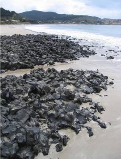
Tahanga Quarries was the most important source of basalt for the creation of stone tools in New Zealand during the first centuries after human arrival. Located at the eastern end of the Kuaotunu Peninsula in the Coromandel, it forms part of an important landscape linked with early settlement in New Zealand and reflects significant connections with East Polynesian culture. Tahanga’s main products were adzes, used for timber felling and woodworking, and perhaps particularly canoe manufacture. The adzes were distributed throughout northern New Zealand, where they are found in some of the country’s earliest known archaeological sites. Tahanga Quarries is situated on the summit and flanks of Tahanga Mountain, extending north to the shore of Opito Bay. It lies within a notable area of early occupation on the Kuaotunu Peninsula and broader Coromandel, which includes settlements at nearby Sarah’s Gully and Skippers Ridge, and on Ahuahu or Great Mercury Island, nine kilometres to the north. Quarrying appears to have been underway at Tahanga by the early fourteenth century, when its adzes were being used as far afield as Houhora in the Far North. Stone was quarried mostly from boulders on the site, although a lava flow in the intertidal zone was evidently also utilised. The main production at Tahanga appears to have been the creation of rough adze preforms on working floors within the complex. ‘Finishing centres’ to complete products through further flaking have been found both nearby and up to 60 kilometres away. The adzes sourced from Tahanga were ‘side hafted’ and of gripped quadrangular form. Similarities between early adzes such as those from Tahanga and those produced in Eastern Polynesia suggests direct contact between New Zealand and other Pacific communities. Comparable basalt quarry sites in the Pacific include those at Tataga Matua in Samoa and Mauna Kea in Hawaii. Tahanga’s significance as a stone source to Maori can be seen in its inclusion in an oral tale which describes how Poutini, a guardian taniwha protecting the mauri or spiritual essence of greenstone, lit a fire on the beach before travelling on to other locations of value for their stone products. The account effectively provides a map of stone resources in New Zealand, and has been described as the country’s first ‘geological survey’. The quarries are likely to have declined by the sixteenth century, although limited production may have occurred into the 1700s. A pa was established on the summit of Tahanga Mountain, believed to have been associated with some ongoing work. The area formed an important place of refuge for Ngati Hei during inter-tribal conflicts, in this latter period and was part of its turangawaewae following incursions in the early nineteenth century. Obtained by the Crown in 1860, the land was subsequently transferred into private ownership and utilised primarily for farming. Since the 1960s, Opito township and associated housing has developed in the immediate vicinity. Most of the site remains in private hands, and is used for a combination of pasture and forestry. Tahanga Quarries has high archaeological significance as a well-preserved and a rare type of archaeological site containing extensive evidence about early quarrying and stone tool production in New Zealand. It has cultural value for demonstrating early links with other communities in the Pacific. It has historical significance for its close associations with the early settlement of New Zealand, and for reflecting the importance of industrial activity in the first few centuries after human arrival. Tahanga Quarries has scientific value for its ability to provide information about the past through methods such as the geochemical analysis of its basalt and basalt products. It has technological value for demonstrating important aspects of tool production, including the application and adaptation of technologies used elsewhere in the Pacific. The place has traditional value for its connections with Poutini and related individuals in traditional history, which reflect the importance of Tahanga as a stone source to Maori.
Location
List Entry Information
Overview
Detailed List Entry
Status
Listed
List Entry Status
Historic Place Category 1
Access
Private/No Public Access
List Number
9419
Date Entered
6th June 2011
Date of Effect
6th June 2011
City/District Council
Thames-Coromandel District
Region
Waikato Region
Extent of List Entry
Extent includes the land described as Lot 1 DPS 86355, Lot 58 DPS 66561 and Lot 1 DPS 26542, and part of the land described as Lot 2 DPS 86355, Lot 2 DPS 22237, Pt Sec 6 Blk III Otama SD, Sec 1 Blk III Otama SD, Opito Bay Road road reserve, and Pt Bed of Opito Bay (RTs SA62C/467, SA21C/1456, SA53D/86, SA1103/131, SA53D/83, Recreation Reserve Sec 35(4) Counties Amendment Act 1961, and NZ Gazette 1918, p.489), South Auckland Land District, and the place known as Tahanga Quarries and its fixtures and fittings. (Refer to map in Appendix 1 of the registration report for further information).
Legal description
Lot 1 DPS 86355, Lot 58 DPS 66561, Lot 1 DPS 26542, Lot 2 DPS 86355, Lot 2 DPS 22237, Pt Sec 6 Blk III Otama SD, Sec 1 Blk III Otama SD, Lot 1 DPS 86355, Lot 58 DPS 66561, Lot 1 DPS 26542, Opito Bay Road road reserve, Pt Bed of Opito Bay (RTs SA62C/467, SA21C/1456, SA53D/86, SA1103/131, SA53D/83, Recreation Reserve Sec 35(4) Counties Amendment Act 1961, and NZ Gazette 1918, p.489), South Auckland Land District.
Location Description
Located immediately east of Opito township, adjoining the foreshore at Opito Bay on the Kuaotunu Peninsula
Cultural Significance
Cultural Significance or Value: The place has cultural significance for demonstrating early links with other communities in the Pacific. Adze forms produced at Tahanga have close parallels in East Polynesia. Basalt quarries exist elsewhere in the Pacific, and Tahanga bears comparison with Tataga Matau in Samoa and Mauna Kea in Hawaii. Traditional Significance or Value: The place has significance for its connections with traditional history, including an account that reflects the importance of the place to Maori. The account links Tahanga to Waitaiki, who was later transformed into greenstone; her abductor Poutini, a guardian taniwha protecting the mauri or spiritual essence of greenstone; and her husband Tamaahua, who subsequently became known in the traditions of many tribes in the Coromandel and northern Bay of Plenty region. Tahanga was the first place visited by Poutini after his abduction of Waitaiki, and where he lit a fire to warm Waitaiki on the beach.
Historic Significance
Historical Significance or Value The place has historical significance for its close associations with the early settlement of New Zealand. It is of value for reflecting the importance of industrial activity in prehistory, notably the production of stone tools. Stone tools performed important roles in early Polynesian New Zealand, being used for a variety of purposes including butchering, timber-working and ceremonial activities. Their manufacture appears to have occurred soon after the first settlers arrived from the Pacific Islands, where the range of available stone was limited to coral limestone and volcanic rock, mostly basalt.
Physical Significance
Archaeological Significance or Value: The place has high significance as a well-preserved and rare archaeological site containing extensive evidence about early quarrying and stone tool production in New Zealand. It was the main site for the production of basalt adzes in New Zealand, and one of just two major sources of stone used for tools in the North Island. The distribution of its products throughout the northern North Island, including in ’finishing centres’, is important for knowledge about trade and exchange, and social and cultural relationships in the first centuries after human arrival. Tahanga is an integral part of a broader archaeological landscape in the eastern part of the Kuaotunu Peninsula that provides important information about early settlement in New Zealand. Scientific Significance or Value: The place has scientific significance for its ability to provide information about the past through means such as the geochemical analysis of its basalt and basalt products. Geochemical analysis can source basalt products to different locations in the Tahanga complex, potentially providing knowledge about organisation, distribution and chronology. Technological Significance or Value: The place has high technological value as a major location for the early quarrying and production of stone tools in New Zealand. It was a main site for the production of stone adzes. It reflects the application and adaptation of technologies used elsewhere in the Pacific. Studies of items from Tahanga have revealed considerable information about how adzes were made, how their form was influenced by the material, which techniques were employed, and in what form the material left the quarry.
Detail Of Assessed Criteria
(a) The extent to which the place reflects important or representative aspects of New Zealand history: The place has outstanding significance for reflecting the East Polynesian origins of early human settlement in New Zealand. It has special value for demonstrating the importance of industrial activity, and notably adze production, in early society. The place reflects changes in later Maori society, including tool production and the construction of fortified pa. Its more recent history demonstrates conversion to European-style farming, including grazing for what has been said to have been the largest herd of Cashmere goats in New Zealand at the time. (b) The association of the place with events, persons, or ideas of importance in New Zealand history: The place is linked with a traditional account referring to stone sources throughout New Zealand that has been described as the country’s first ‘geological survey’. The place is linked with Tamaahua - known to many tribes in the Coromandel and northern Bay of Plenty region - his wife Waitaiki, and Poutini, a guardian taniwha protecting the mauri or spiritual essence of greenstone. (c) The potential of the place to provide knowledge of New Zealand history: The place has outstanding to potential to provide knowledge of New Zealand history as a rare, well-preserved and extensive example of an early basalt quarry and tool production centre. It can provide information about quarrying and tool production techniques, the organisation of early society in New Zealand, and patterns of trade and exchange. It is particularly notable for its ability to shed light on relationships between New Zealand and other parts of the Pacific, where basalt quarries and products were similarly utilised. The place is a central part of an early occupied landscape in the Opito area that can help unravel the settlement history of New Zealand, especially the first hundred years for which there are very few identified sites. (d) The importance of the place to the tangata whenua: The place is considered to be of high importance to Ngati Hei. It forms part of a confined area in the eastern Kuaotunu Peninsula, which was their turangawaewae following inter-tribal conflicts in the early nineteenth century. The reputation and durability of the tools made from Tahanga basalt have been considered to have added greatly to the mana and wellbeing of Ngati Hei. In addition to the maunga, the site contains other locations of particular significance to Ngati Hei, such as Ratoka. (g) The technical accomplishment or value, or design of the place: The place has special technical value for physically articulating an important step in the technological development of human society in New Zealand: the creation of stone tools from local raw materials. The site contains visible evidence of quarrying and the initial processing of tools. Technologies brought to New Zealand were applied and adapted to a type of stone that is likely to have been recognisable from elsewhere in the Pacific. Basalt was a particularly important source of stone for toolmaking, especially adzes, due to its resilience and strength. Adzes were a valued tool in early societies, enabling activities such as canoe-production and other timber-working to take place. (i) The importance of identifying historic places known to date from early periods of New Zealand settlement: The place has outstanding significance as a site that was occupied and used soon after the first human settlement of New Zealand. Its products have been found in the earliest known sites in the northern North Island, including an extensive quantity at Houhora which has been radiocarbon-dated to the early fourteenth century. (j) The importance of identifying rare types of historic places: The place has outstanding significance as a rare example of a quarry and adze production centre dating to the first centuries after human arrival in New Zealand. It was one of two main areas of stone material in the North Island used during the first few hundred years of settlement, and the major source of basalt in New Zealand for adzes. The scale of production and distribution of Tahanga adzes is significantly higher than elsewhere. (k) The extent to which the place forms part of a wider historical and cultural complex or historical and cultural landscape: The place has outstanding significance as an integral component of an important cultural and historical landscape in the eastern Kuaotunu Peninsula, which is linked with early human settlement in New Zealand. Notable early settlements in the vicinity include those at Sarah’s Gully and Skippers Ridge. A large number of sites on the peninsula and at nearby Ahuahu or Great Mercury Island contain basalt flakes indicating that they were ‘finishing centres’ for the production of Tahanga adzes and associated tools. Summary of Significance or Values: This place was assessed against, and found it to qualify under the following criteria: a, b, c, d, g, i, j and k. Conclusion: It is considered that this place qualifies as a Category I historic place because it reflects the East Polynesian origins of early human settlement in New Zealand; demonstrates the importance of industrial activity, and notably adze production, in early society; and can provide knowledge of New Zealand history as a rare, well-preserved and extensive example of an early basalt quarry and tool production centre. It also qualifies because it articulates an important step in the technological development of human society in New Zealand - the creation of stone tools from local raw materials; and is an integral component of an important cultural and historical landscape in the eastern Kuaotunu Peninsula, which is linked with early human settlement in New Zealand.
Construction Details
Description
Quarries in use
Period
Early 14th century
Type
Other
Description
Widespread use of quarries likely to have ceased
Period
Circa 16th century
Type
Other
Description
Fortified pa created on the summit of Tahanga Mountain, associated with limited stone-working
Period
Pre-18th century
Type
Other
Description
Conversion to farmland
Period
Late 19th or early 20th century
Type
Other
Description
Seasonal camping ground established beside foreshore
Period
Late 1950s
Type
Other
Description
Modern quarrying on eastern side of Tahanga Mountain
Period
Circa 1960s
Type
Other
Description
Seasonal camping ground closed
Period
1990s
Type
Other
Description
Pine plantations established
Start Year
1997
Type
Other
Early occupation of the Tahanga area: Tahanga forms part of an important historical and cultural landscape on the eastern side of the Coromandel peninsula, which contains widespread evidence of early human settlement in New Zealand. Traditional Maori sources link the area with early exploration, notably by the legendary travellers Toi and Kupe. The Coromandel is known as ‘Te Paeroa o Toi’ or ‘Toi’s long mountain ridge’; the Whitianga River is ‘Whitianga o Kupe’ or ‘Kupe’s crossing.’ A pearl shell lure discovered at Tairua, some 30 km to the south of Tahanga, is identical to types found in the Marquesas Islands, and has been considered the only object of non-New Zealand origin found in any archaeological site of the period. It may indicate that the area was included in the earliest phases of discovery and settlement by arrivals from East Polynesia, perhaps in the thirteenth century. The Kuaotunu Peninsula, at the eastern end of which Tahanga is located, is particularly notable for providing knowledge about human activity in the first centuries after discovery, and has been regarded to have been a focus for Maori activity during this period. A site at Sarah’s Gully, between Otama and Opito Bay, is one of only two early locations in the North Island for which information on village layout and use of space has been uncovered. It incorporated houses, storage pits, ovens and other features, and contained burials inside the settlement - typical of East Polynesian custom at the time. Even closer to Tahanga, excavations at Skippers Ridge have revealed a settlement with pits of various shapes, which was probably occupied before the fifteenth century. These and other sites in the vicinity appear to have been occupied in association with Tahanga, which is likely to have been discovered early on during the exploration of New Zealand. Tahanga itself is a prominent mountain overlooking Opito Bay to the north, and was a major source of basalt for early peoples. Basaltic stone was used elsewhere in the Pacific for tool production, and the creation of adzes in particular. Notable sources included Mauna Kea in Hawaii, Tataga Matua in Samoa, the Society Islands, Eaio in the Marquesas Islands, and Pitcairn Island. Quarrying basalt for adze production at Tahanga is considered to have begun on the site by the early fourteenth century. The organisation of initial peoples in the area is unknown, although it is believed that the current tangata whenua of Tahanga - Ngati Hei - represent a welding together of earlier populations with chiefly lines of Arawa origin. Ngati Hei trace their ancestry from Hei, variously given as elder brother or uncle of Tamatekapua, ariki of the Arawa canoe, who settled in the Coromandel shortly after the arrival of Te Arawa in New Zealand. Early stone tool manufacture in New Zealand: Stone tools performed important roles in early Polynesian New Zealand, being used for a variety of purposes including butchering, timber-working and ceremonial activities. Their manufacture appears to have occurred soon after the first settlers arrived from the Pacific Islands, where the range of available stone was limited to coral limestone and volcanic rock, mostly basalt. Evidence for stone working on some early sites in New Zealand indicates that experimentation with unfamiliar materials such as mudstones and silicious limestones may have taken place, as at Clarence Mouth and Kaikoura in the South Island. Other production utilized greywacke, obsidian and argillite. Basalt is likely to have been a more familiar, and possibly more sought after material, particularly valued for the production of larger items such as adzes. The most important source of basalt exploited in New Zealand’s early history was that from the flanks of Tahanga Mountain. Adze production at Tahanga: Tahanga’s significance as a stone source to Maori can be seen in its inclusion in an oral tale about Poutini, a guardian taniwha protecting the mauri or spiritual essence of greenstone. The account effectively provides a map of stone sources in New Zealand from which valued material was quarried, and has been described as the country’s first ‘geological survey’. Tahanga is the place where Poutini first took Waitaiki, the wife of Tamaahua, whom he abducted from nearby Tuhua or Mayor Island. Poutini lit a fire on the beach, in order to warm Waitaiki. Pursued by Tamaahua, the pair subsequently travelled on to other notable stone sources throughout the North and South Islands, including Whangamata (a source of black obsidian), Rangitoto or D’Urville Island (metamorphised argillite) and Onetahua or Farewell Spit (‘floater’ stones from the Nelson mineral belt), before Waitaiki was transformed into greenstone in the upper Arahura River. Tamaahua returned to Tuhua, itself a source of obsidian, and later became known in the traditions of many tribes in the Coromandel and northern Bay of Plenty region. The main basalt sources used for adze production at Tahanga are located to the south of Opito Beach, on and around Tahanga Mountain. Exploitation evidently occurred from early in New Zealand prehistory, although the workings are dated only indirectly through the discovery of its adzes on other sites. Moore suggests that Tahanga was an important centre for adze manufacture and distribution from about 1300 to 1500 A.D. Its adzes have been found in some of the earliest dated archaeological sites in the northern half of the North Island, including Houhora in the Far North, where examples may pre-date most of those found closer to the quarries. The settlement at Houhora has been radiocarbon-dated to the early fourteenth century and contained a large number of Tahanga adzes despite local basalt being available from nearby Mount Camel. Stone adzes are believed to have been used primarily for tasks linked with timber felling and woodworking, being attached to timber hafts as a functioning tool. Considered by some as the most important tool available to early Maori, they were initially manufactured by being hammered and pecked to produce the right finish, although later methods in prehistory preferred sawing and grinding. Some of the basalt at Tahanga was particularly suitable for quality adze production, being fine-grained and capable of flaking well. Variability in the quality of the rock, however, resulted in not all sources being exploited, with the finest-grained preferred for adze manufacture. At Tahanga, the quarries mostly consisted of weathered boulders at, or largely exposed on, the ground surface. Sources from the slopes of Tahanga Mountain were the most heavily utilized, along with beach sources alongside Opito Bay, which would have provided boulders, cobbles and blocks. Material from a smaller hill to the east of Tahanga was used only to a limited extent. Geochemical tests have identified six sub-sources spread over an extensive area, measuring some 1.5 km x 1.3 km. The sub-sources are i) Tahanga Mountain, ii) a ridge south of Tahanga, iii) a hill east of Tahanga, iv) a conical hill at the eastern end of Opito Bay beach, v) a spur truncated by Opito Bay beach, and vi) large basalt blocks in the intertidal zone. This work, reported on by Felgate et al in 2001, opens up the possibility of sourcing artefacts made of Tahanga basalt to one of these particular areas. The testing of adzes from Houhora, for example, has indicated that they were from sub-sources i) and vi). More widespread testing of adzes from other sites has the capacity to refine distribution patterns for Tahanga products, and may shed light on chronological development within the exploitation of different parts of the Tahanga site. Further analysis from Tahanga itself could yield information on the internal movement of material within the site, assisting knowledge of organisation and process. All six of the identified sub-sources are included inside the registration boundaries. As most of the stone was exposed on the ground surface, little physical effort to extract the raw material was generally required. An exception may be a lava flow in the inter-tidal zone, which bears signs of conchoidal fracture for the removal of raw material. This was evidently used until the resource was exhausted. In general, the stone was subsequently shaped and trimmed on working floors to produce roughed out adze blanks. Working floors typically accumulated material from various stages of the process, including broken rough outs and reject pieces, and the hammerstones used to help shape the blanks. Variability in the quality of stone influenced the end product and often required special techniques. Archaeological analysis of waste debris has focused on how adzes were made, how their form was influenced by the material, which techniques were employed, and in what form the material left the quarry. A large number of working floors were employed at Tahanga, two of which have been investigated in more detail by archaeologists. Three excavations were carried out on a large area of debitage on the northern slopes of Tahanga Mountain (T10/400) between 1962 and 1965. The other site (T10/459) was investigated by Kronqvist in 1990 to the south of Tahanga. Preforms were transported to a number of places up to 60 km away for further processing and finishing. ‘Finishing centres’ have been identified at many locations, from nearby Opito and Ahuahu (Great Mercury Island) to Whitianga, Hahei and Mt Maunganui. The quantity of flakes at some sites suggests that such work may have extended beyond that required for local use. Flakes were utilised for tools other than adzes, such as drill points, cutters, scrapers and awls. Adze forms and distribution: It has been demonstrated that Tahanga basalt and Nelson meta-argillite are the two most common stone types used to produce the distinctively early - and New Zealand-wide - ‘side hafted’ adze form. The adzes created at Tahanga were also characterized by their gripped quadrangular form. These differ from adzes produced elsewhere in the North Island at a later date, which were generally ungripped. Some experts have considered that the earlier gripped adzes were more effective for canoe production, while later types indicate a greater emphasis on activity linked to land clearance and the construction of defensive structures, being more useful for timber felling. Similarities between the form of early adzes such as those produced at Tahanga and those from Eastern Polynesia suggests direct contact between New Zealand and other Pacific communities. These may even have been of an ongoing nature, with some reverse influence from this country to other islands. The gripped side-hafted adze form, for example, is uniquely shared between New Zealand and Pitcairn Island, as well as a spade-shouldered form. It has been noted that comparison of technology and adze styles with quarries elsewhere in the Pacific is ‘important both for studies of Polynesian material culture change, and the development and transfer of ideas and technology through different island groups over time.’ Comparisons closer to home may also indicate contact and the cross-fertilisation of ideas between different groups within New Zealand. For the first few hundred years of human settlement, Tahanga was one of only two main stone sources in the North Island. The distribution of Tahanga adzes from Hawkes Bay in the south to the Aupouri Peninsula in the north potentially provides valuable information about patterns of trade or exchange. The indications are that long-distance contact in the early period gradually diminished, with later distribution becoming more localised until the production of adzes from Tahanga basalt effectively ceased as a major operation, perhaps during the sixteenth century. The reasons for this are unclear, although by this time new forms of adzes were being produced in other centres using different stone and production techniques, notably bruising and grinding rather than flaking. Subsequent use of the site: In later centuries, after the importance of the quarry had waned, settlement in the immediate vicinity continued, and easily defended places such as the summit of Tahanga Mountain were turned into fortified pa. Remains dating to the later period indicate a small population, periodically under threat from their neighbours, who made a living by fishing, gathering shellfish, gardening on the lower ridges and flats, and exploiting the resources of the sea, forests and wetlands in the vicinity. The quarries at Tahanga continued to be exploited as a source of local material, but without the same skill in flaking that is evident in the earlier period. Evidence for limited ongoing exploitation may include the presence of stone flakes on the top of Tahanga Mountain, which are probably associated with the pa site. It has been stated that the products of large quarries in New Zealand did not travel as far as previously in this later period, although the quarries themselves continued in use until the eighteenth century. Archaeological investigations at Opito indicate that Tahanga basalt continued to be used locally into the 1700s. During this period and later, the traditional occupants of Tahanga, Ngati Hei, were considerably affected by successive incursions into the Coromandel peninsula. An early nineteenth-century battle with Ngapuhi at Matapaua (Peys Bay), immediately to the south of Tahanga, led to the death of a notable Ngati Hei leader, Pereki Awhiowhio. It has been considered that fortified pa in the Rama Rama and Puhiwai Blocks - respectively to the west and south of Tahanga - were utilised until the mid 1800s, and formed refuges for Ngati Hei during conflict with other iwi. In 1853, Ngati Hei continued to occupy a settlement close to the site, at Te Raupuha, Matapuaua. The eastern end of the Kuaotunu Peninsula, including Tahanga Mountain and Te Raupuha, have been considered to represent the turangawaewae of Ngati Hei following the conflicts of the early nineteenth century. Late nineteenth- and twentieth-century history: In November 1860, the Crown purchased the Opito Block incorporating much of the site at Tahanga. The Puhiwai Block, containing the southern remainder of the site, passed to the Crown at a similar time although a claim lodged by Peneamene Tanui in 1883 stated that it was not included in the same sale. As a prominent feature, the top of Tahanga Mountain marked the boundary between the two blocks. The summit was the site of a Trig Station employed in the early survey of the area by Charles Clayton. The formal transfer of land from the Crown to European settlers began in 1878, when land on the northern slopes of Tahanga adjoining Opito Bay was granted to John Bunyan Ferguson, described as a farmer of Mercury Bay. Centred on the basalt outcrop adjoining the beach, the eastern part of Ferguson’s grant was surveyed in August 1877, shortly after he had applied for land at Opito Bay for the purposes of establishing a fishing station. In 1879, his property was transferred to Hugh Ferguson, Master Mariner. The remainder of the site at Tahanga remained in Crown hands until well into the twentieth century. In 1917, Ferguson’s land was purchased by Isabella Stewart, wife of John Stewart, farmer. A road through the property was gazetted the following year, allowing direct access from the beach to the eastern slopes of Tahanga Mountain. Stewart obtained further land on the western flanks of the mountain from the Crown in 1925, shortly before her holdings were sold to another farmer, William Parsons Thompson, who had leased the remainder of the mountain - including the summit - from the Crown since at least 1913. Thompson’s farm was evidently a marginal enterprise in which vegetation was burnt off to graze cattle and sheep. Subsequent owners catered for increasing recreational interest in the bay by subdividing land immediately to the west of the site beside Opito Beach for the construction of holiday homes. Seasonal camping also took place close to the foreshore in the eastern part of the site between the late 1950s and early 1990s. The farm supported a herd of purebred Cashmere goats which was added to by further stock imported from Australia, and is said to have been the largest in New Zealand at the time. Some quarrying of modern date occurred within the site, on the eastern slopes of Tahanga Mountain. The archaeological value of the site was not immediately recognised when groundbreaking work by Jack Golson was undertaken at nearby Sarah’s Gully in the 1950s. Recognition of the archaeological significance of Tahanga dates from the early 1960s, since when the area has been the subject of many surveys, excavations and other investigations. Work from the 1970s to the 1990s particularly advanced knowledge of the site and its importance. Many prominent members of the archaeological community have been involved, generating a considerable body of research. Ngati Hei have considered that the reputation and durability of the tools made from Tahanga basalt have added greatly to the mana and wellbeing of Ngati Hei. In the 1990s, two residential dwellings were constructed on land close to the Opito Bay foreshore, which has been excluded from the registration due to modification of the landscape at that time. More extensive development has occurred in Opito township, including on previously significant archaeological sites close to the foreshore. As these sites are also considered to have been largely destroyed, this area has been similarly excluded. Extensive tree planting occurred on the lower slopes of Tahanga in 1997. Most of the land is currently in private ownership, and is employed for both pastoral and forestry use. Most of the land is currently in private ownership, and is employed for both pastoral and forestry use.
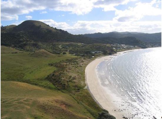
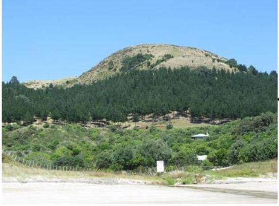
Context: The site at Tahanga lies near the eastern end of the Kuaotunu Peninsula, which protrudes into the Hauraki Gulf on the eastern side of the Coromandel peninsula. The Kuaotunu landscape combines steep mountains and hills in the interior, large bays along the foreshore - notably on the northern side of the peninsula - and several small offshore islands to the east. Ahuahu or Great Mercury Island lies just six kilometres to the north of the Kuaotunu coastline and nine kilometres to the north of Tahanga. The maunga or mountain at Tahanga is a prominent local landmark, dominating the eastern end of the peninsula. It overlooks a large sandy beach and flat ground at Opito Bay to the north, and a smaller bay at Matapaua to the south. The Tahanga Quarries site is located immediately to the east of Opito Township, which adjoins Opito Bay. Opito Township consists mostly of houses erected since the 1960s, and extends from the foreshore to the lower flanks of Tahanga Mountain. The eastern part of the Kuaotunu Peninsula forms a rich archaeological landscape, of particular note for its connections with early human settlement in New Zealand. Including locations within the Tahanga Quarries registration boundary, a total of at least 57 archaeological 'sites’ have been recorded on the Peninsula east of Matapaua Bay Road. Other places of archaeological importance in the vicinity include early settlements at Skippers Ridge and Sarah’s Gully, which have been linked chronologically to Tahanga. Tahanga itself looks directly across to Great Mercury Island, which is a closely connected landscape containing large numbers of basalt flakes that suggest it was one of the main places where Tahanga adzes were finished. The site: The site encompasses an area of approximately 200 hectares to the east of the Matapaua Bay Road. It occupies land around and including the summit of Tahanga Mountain, and extends northwards from the mountain to incorporate outlying knolls and a low ridge that runs down to the Opito Bay foreshore. It includes a lava flow in the intertidal area along the foreshore, which was a known source of basalt for tool-making and which contains physical indications of quarrying. The northern end of the ridge, including the intertidal lava flow, is known to Ngati Hei as Ratoka. Parts of a watercourse known as Waikere, to the east of the ridge, are also encompassed. The summit of Tahanga Mountain and some other parts of the site, including the low ridge, are covered with grass. Much of the rest, particularly the lower slopes of the mountain, has been planted with pine trees. Basalt boulders and occasional outcrops of rock are found throughout the site. The site includes at least three eruption centres. The site in its entirety can be considered a working landscape, used for the quarrying of basalt and initial working of tools - particularly adzes. It includes a large number of separately recorded archaeological sites, although intervening spaces are also likely to have been utilised. The recorded sites reflect activity that is - or has been - visible on the surface of the land, and are detailed below. Recorded archaeological sites: Fifteen recorded archaeological sites lie within the registration boundaries, mostly consisting of quarries and working floors, as well as a later pa. The pa appears to be associated with ongoing stone working after the main period of adze production. Although recorded as distinct sites, eroding sections have revealed further concentrations of debitage in places where there is no evidence at ground surface level. In places the working floors overlap and merge into one another. From west to east, the recorded archaeological sites are: T10/974: Identified in 1995, the site lies on the lower western flanks of Tahanga Hill. It consists of an area of debitage measuring at least 10 m x 15 m. T10/975: Also identified in 1995, an area of debitage partially disturbed by a farm track to the southwest of Tahanga Mountain. T10/166: A large site with extensive evidence of adze manufacture. It is situated on the western flank of Tahanga Mountain and occupies an area measuring 100 m x 50 m. It contains boulders, flakes, preforms and hammerstones. T10/400: Situated on the northern flank of Tahanga Mountain, on its middle and lower slopes. The site contains numerous piles of boulders, many containing debitage from adze manufacture. Three excavations have been carried out on the site between 1962 and 1965. T10/172: A large pa on very steep ground at the top of Tahanga Mountain, covering some 0.4-0.8 ha (1-2 acres). The site incorporates terracing, pits and possible house platforms. No defensive banks or ditches are visible, although the pa is surrounded by a ‘wall’ made of large boulders. A very small area of flaking measuring 2m x 2m on top of the hill is considered likely to be associated with occupation of the pa. T10/459: The site consists of two boulder fields with small scattered working floors on the south and southeast side of Tahanga Mountain. An excavation was carried out on the site in 1990-91. T10/401: A large area on the eastern side of Tahanga Mountain, consisting of outcrops, boulders and small working floors. T10/201: Boulder piles or working floors at the northern end of the low ridge extending from Tahanga Mountain to the Opito foreshore, on its eastern side. The site is reported to have been badly damaged or destroyed by 2003. Land associated with the site has been retained within the registration boundaries because of its significance as part of Ratoka; its associations with the area of quarried stone at the northern end of the ridge; and its immediate proximity to the beachfront linked by oral tradition to Poutini, Waitaiki and Tamaahua. It is also unclear to what extent remnants of T10/201 might survive below ground. T10/855: A boulder field measuring approximately 400 m x 250 m in extent on the northeastern lower slopes of Tahanga Mountain. It contains an irregular scatter of debitage. T10/856: A scatter of debitage 30 m x 50 m in extent, to the east of Tahanga Mountain. T10/857: An area of debitage to the east of Tahanga Mountain and to the south of T10/856. T10/858: Two small areas of debitage to the east of Tahanga Mountain and to the south of T10/857. T10/457: Located on small hill to the east of Tahanga Mountain. The site contains a scatter of debitage at the bottom of a boulder field. T10/458: Located on the same small hill as T10/457. It contains a small scatter of debitage. T10/620: A small hillock or knoll to the northeast of Tahanga Mountain and close to the Opito Bay foreshore, with debitage associated with several boulder piles. In 2006, piles were noted extending in linear arrangements from the lower slopes to midway up the hillock. Further unrecorded sites almost certainly exist within the registration boundaries. Excluded areas: Two houses and their immediate surrounds beside the foreshore to the east of the low ridge have been excluded from the registration. This part of the site - which lies within Lot 2 DPS 86355 - is considered likely to have been significantly modified during construction work in the 1990s. Other properties on the western side of the low ridge, including those on the site of T10/200 (working floors), T10/248 (terraces) and T40/940 (midden/work area) have been excluded for the same reason. The possibility of some archaeological remnants surviving on these and other excluded areas is not precluded. A recently recorded working surface some distance to the southeast of Tahanga Mountain (T10/976) has been omitted as an outlier. Comparisons: Tahanga is the only major site of basalt adze production in early New Zealand. It is, however, one of a number of major basalt quarries in Polynesia and bears comparison with Tataga Matau in Samoa and Mauna Kea in Hawaii. Adze production from basalt at the main Mauna Kea quarry, Keanakako’i, is considered to have begun as early as 1100 A.D., with intensive activity after 1400 A.D. Adze makers are believed to have come from neighbouring areas for short periods, and used different areas for chipping, rough-finishing and fine-finishing the tools. Upright stones were erected, which have been interpreted as shrines. Adze products were widely used. Tataga Matau in American Samoa is considered to have been one of the largest basalt quarries in the Pacific, incorporating activities that extended beyond basalt extraction. It incorporates extensive earthworks associated with basalt workshop areas and flaking floors. Radiocarbon dates indicate use over at least a 300 year period. Basalt adzes from Samoa have been found as far afield as the Cook Islands.
Public NZAA Number
T10/166
Completion Date
6th June 2011
Report Written By
M. Jones, T. Walton
Information Sources
Archaeology in New Zealand
Archaeology in New Zealand
New Zealand Journal of Archaeology
New Zealand Journal of Archaeology
New Zealand Archaeological Association (NZAA)
New Zealand Archaeological Association
Journal of the Polynesian Society
Journal of the Polynesian Society
Davidson, 1984
J Davidson. (1984). The Prehistory of New Zealand. Auckland: Longman Paul.
Theses and Essays
Theses and Essays
Reports
Reports
He Korero, 1990
He Korero Purakau Mo Nga Taunahanahatanga A Nga Tupuna / Place Names of the Ancestors: A Maori Oral History Atlas, Wellington, 1990
Sewell, 2007
Brenda Sewell, Opito and Beyond, Wellington, 2007
Report Written By
A fully referenced Registration Report is available from the NZHPT Northern Region office Please note that entry on the New Zealand Heritage List/Rarangi Korero identifies only the heritage values of the property concerned, and should not be construed as advice on the state of the property, or as a comment of its soundness or safety, including in regard to earthquake risk, safety in the event of fire, or insanitary conditions.
Current Usages
Uses: Agriculture
Specific Usage: Paddock
Uses: Forestry
Specific Usage: Forestry - other
Former Usages
General Usage:: Maori
Specific Usage: Flake area/ stone working area
General Usage:: Maori
Specific Usage: Pā
General Usage:: Maori
Specific Usage: Quarry
Themes
Waka-Wairua
Of Significance to Maori
Stay up to date with Heritage this month
