DonateSupporterVisit Heritage
  • Tūrangawaewae
    Places
  • Tira Māori
    Māori Heritage
  • Poutairangahia
    Archaeology
  • Rauemi
    Resources
  • Mō Tātou
    About Us
  • New Zealand Heritage List
  • Nominate and submit
  • Explore the List
  • National Historic Landmarks
  • Plaques
  • Rainbow List Project
  • Lost heritage
  • Visit Heritage
  • Our properties
  • Turnbull House Project
  • Collections
  • Shop
  • Tohu Whenua
  • Tira Māori
  • Conserving Māori heritage
  • Marae built heritage
  • Māori heritage on the List
  • Hinemihi—Te Hokinga Mai
  • What is archaeology?
  • Is there a site on my property?
  • What are my legal requirements?
  • Affecting an archaeological site
  • Declaring an archaeological site
  • Archaeology FAQs
  • Archaeology Digital Library
  • Archaeology guidelines and templates
  • Resources
  • Funding
  • Publications
  • Sustainable management guides
  • Disaster recovery
  • Podcasts & digital resources
  • Education Hub
  • Conservation plans
  • About
  • Board
  • Māori Heritage Council
  • Senior Staff
  • Offices
  • Contact us
  • Careers
  • Covenants
  • Fast-track
  • Corporate documents
  • Currently consulting on
  • Our submissions
  • News
Quick links
Rārangi Kōrero | The List
Explore the List
National Historic Landmarks
Ngā Manawhenua o Aotearoa me ōna Kōrero Tūturu
Quick links
Tapuwae
A Vision for Places of Māori Heritage
Funding for Māori Heritage
Resources
Quick links
Archaeological Authority Portal
Applying for an archaeological authority
Archaeology FAQs
Browse the most frequently asked questions about archaeological authorities and the archaeological process.
Quick links
Quick links
Contact us
Offices
DonateSupporterVisit Heritage
  • Tūrangawaewae
    Places
  • Tira Māori
    Māori Heritage
  • Poutairangahia
    Archaeology
  • Rauemi
    Resources
  • Mō Tātou
    About Us
  • New Zealand Heritage List
  • Nominate and submit
  • Explore the List
  • National Historic Landmarks
  • Plaques
  • Rainbow List Project
  • Lost heritage
  • Visit Heritage
  • Our properties
  • Turnbull House Project
  • Collections
  • Shop
  • Tohu Whenua
  • Tira Māori
  • Conserving Māori heritage
  • Marae built heritage
  • Māori heritage on the List
  • Hinemihi—Te Hokinga Mai
  • What is archaeology?
  • Is there a site on my property?
  • What are my legal requirements?
  • Affecting an archaeological site
  • Declaring an archaeological site
  • Archaeology FAQs
  • Archaeology Digital Library
  • Archaeology guidelines and templates
  • Resources
  • Funding
  • Publications
  • Sustainable management guides
  • Disaster recovery
  • Podcasts & digital resources
  • Education Hub
  • Conservation plans
  • About
  • Board
  • Māori Heritage Council
  • Senior Staff
  • Offices
  • Contact us
  • Careers
  • Covenants
  • Fast-track
  • Corporate documents
  • Currently consulting on
  • Our submissions
  • News
Quick links
Rārangi Kōrero | The List
Explore the List
National Historic Landmarks
Ngā Manawhenua o Aotearoa me ōna Kōrero Tūturu
Quick links
Tapuwae
A Vision for Places of Māori Heritage
Funding for Māori Heritage
Resources
Quick links
Archaeological Authority Portal
Applying for an archaeological authority
Archaeology FAQs
Browse the most frequently asked questions about archaeological authorities and the archaeological process.
Quick links
Quick links
Contact us
Offices
  • Places
  • Nominate and submit
  • National Historic Landmarks
  • Places
  • Nominate and submit
  • National Historic Landmarks
  • Tira Māori
  • Conserving Māori heritage
  • Marae built heritage
  • Tira Māori
  • Conserving Māori heritage
  • Marae built heritage
  • Archaeological authorities
  • Archaeology Digital Library
  • Archaeological authorities
  • Archaeology Digital Library
  • All resources
  • Publications
  • Funding
  • All resources
  • Publications
  • Funding
  • FAQs
  • FAQs
Follow us on:
Places
  • Places
  • Nominate and submit
  • National Historic Landmarks
Tira Māori
  • Tira Māori
  • Conserving Māori heritage
  • Marae built heritage
Archaeology
  • Archaeological authorities
  • Archaeology Digital Library
Resources
  • All resources
  • Publications
  • Funding
FAQs
  • FAQs
Follow us on
HomePrivacyTerms and conditionsAbout this site
© Heritage New Zealand Pouhere Taonga 2026.
 
Rocks Road Chain Fence

Rocks Road and Wakefield Quay, NELSON

Public

Historic Place Category 1

List No. 254

Quick links:
List GalleryLocationDetails
Since 1898 the Rocks Road Chain Fence has marked the perimeter of Rocks Road from the Nelson Harbour, and served as a symbol of the practical generosity of Nelson settlers John Tinline and Thomas Cawthron.

The Rocks Road Chain Fence was an integral part of a project to construct a road between the city of Nelson and the nearby settlement of Tahunanui. According to the local newspaper, 'the fear of the sea encroaching as well as the inconvenience of the hills had made the work necessary'. Prior to the road's construction, travellers had been forced to take the dangerous route around the rocks below the cliff face at low tide.

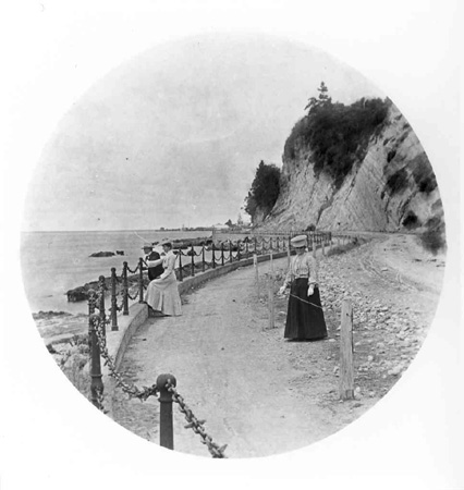
The project was first mooted in 1876. Local councils formed a road committee in 1891 and the surveyor and engineer Sam Jickell was commissioned to construct a concrete seawall. The wall was built by prisoners from the Nelson Gaol and completed in 1897. The Chain Fence was erected along part of the wall in 1898 to protect the public from the vertical drop into the sea below. Suggested and funded by Nelson settler John Tinline, the concept was inspired by the fences lining seafronts in England. Rocks Road was constructed between the wall and the cliff face. Built of materials excavated from the cliffs, it was completed at the cost of almost £12,000, and officially opened by Premier Richard John Seddon [1845-1906] in 1899.

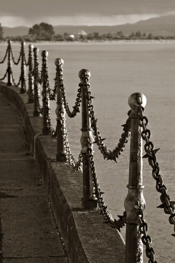
The sturdy Rocks Road Chain Fence highlights the curving nature of the seawall and cliff face of the road. It is composed of a double row of chains strung between stanchions placed 3.2 metres apart. The elaborate stanchions are made of cast iron and cost £140. Perched on top of a raised concrete curb, the stanchions stand on short, square bases and taper towards the top. The chains cost £400. They are hung from spheres at the middle and top of each stanchion. Driven into the chains at regular intervals are short, iron spikes.

The fence, which originally covered just 1.1 kilometres, now protects almost two kilometres of the road. In 1912 Thomas Cawthron [1833?-1915], a prominent Nelson businessman and noted philanthropist, offered to pay for the fence to be extended along unprotected parts of the road after a cyclist was killed falling from the road onto the rocks below the seawall. The fence was extended by 784 metres [39 chains] under the supervision of city engineer J. G. Littlejohn for £218, leaving the eastern end of the road exposed. The stanchions for the fence extension were forged in Nelson at the Anchor Shipping and Foundry Company and the chains were imported from England. Cawthron advocated for the completion of the work until his death in 1915. The fence was finally extended towards the east after another serious accident later that year. It was paid for out of Cawthron's estate.

Despite minor changes prompted by the reinforcement of the seawall in 1958, and the replacement of chains and stanchions due to rust, the Rocks Road Chain Fence remains a prominent and practical feature of Rocks Road.

The Rocks Road Chain Fence has national significance as an example of Victorian street furniture. The imported chains and the English-inspired design provide insight into the aspirations of the growing city of Nelson in the late nineteenth century. The fence has considerable historical importance. As Rocks Road and the original seawall were extensively altered in the second half of the twentieth century, the fence is one of the last original, visible reminders of the development and spread of Nelson City towards Tahunanui. The length of the fence draws attention to the seawall, which has technological interest, and the line reflects the original curves of Rocks Road as designed by Sam Jickell. Funded by two prominent Nelson settlers, the fence is evidence of their practical generosity to the city and serves as a memorial to them. The Chain Fence has considerable aesthetic value and is an outstanding feature of the Nelson waterfront and the Rocks Road streetscape.
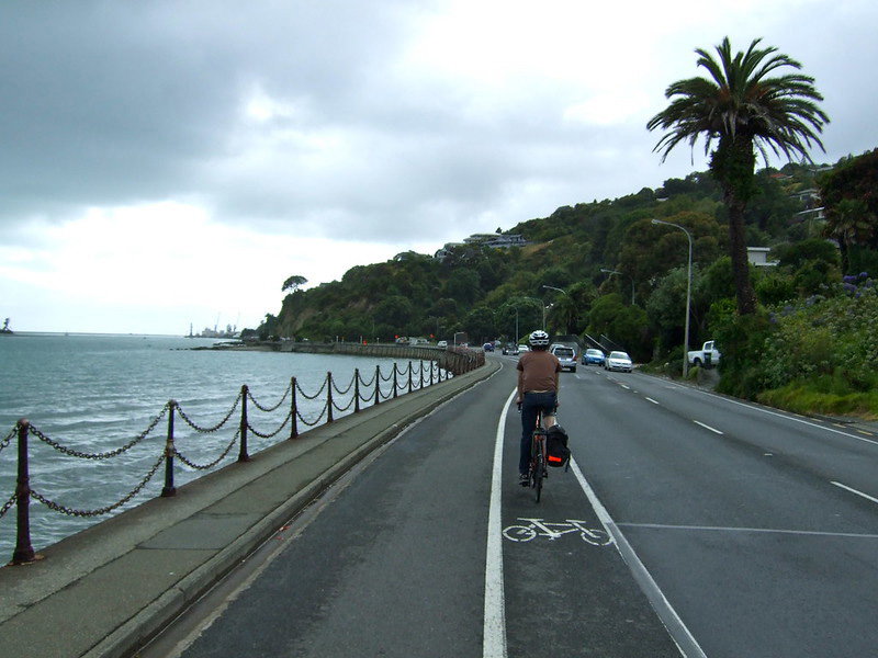
Rocks Road Chain Fence, Nelson. CC BY-SA 2.0 Image courtesy of www.flickr.com | Mike Locke | 10/05/2008 | Mike Locke
Rocks Road Chain Fence, Nelson. CC BY-NC-SA 2.0 Image courtesy of www.flickr.com | Meghan Deutscher | 04/03/2012 | Meghan Deutscher
Rocks Road Chain Fence. 'The fence shortly after it was erected in 1898. Rocks Road was officially opened by Premier Richard John Seddon in 1899 | Copy Collection, Nelson Provincial Museum, C3539
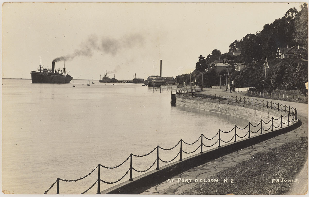
Rocks Road Chain Fence, Nelson. c.1900s Port of Nelson, NZ. Image courtesy of Museum of New Zealand Te Papa Tongarewa photography collection. Reg. No PS. 003129 | F. N. Jones Photographs, Nelson, NZ Series | No Known Copyright Restrictions
Rocks Road Chain Fence, Nelson. CC BY-SA 2.0 Image courtesy of www.flickr.com | Mike Locke | 10/05/2008 | Mike Locke
Rocks Road Chain Fence, Nelson. CC BY-NC-SA 2.0 Image courtesy of www.flickr.com | Meghan Deutscher | 04/03/2012 | Meghan Deutscher
Rocks Road Chain Fence. 'The fence shortly after it was erected in 1898. Rocks Road was officially opened by Premier Richard John Seddon in 1899 | Copy Collection, Nelson Provincial Museum, C3539
Rocks Road Chain Fence, Nelson. c.1900s Port of Nelson, NZ. Image courtesy of Museum of New Zealand Te Papa Tongarewa photography collection. Reg. No PS. 003129 | F. N. Jones Photographs, Nelson, NZ Series | No Known Copyright Restrictions

List Entry Information

Overview

Status
Listed

List Entry Status
Historic Place Category 1

Access
Able to Visit

List Number
254

Date Entered
16th November 1989

Date of Effect
16th November 1989

City/District Council
Nelson City

Region
Nelson Region

Extent of List Entry

Extent includes part of the land identified as Legal Road, Nelson Land District, and the structure referred to as Rocks Road Chain Fence thereon, and a curtilage extending 1 metre on either side of the fence. Refer to the map tabled at the Rārangi Kōrero Committee meeting on 31 July 2025.

Legal description

Legal Road, Nelson Land District

Location Description

The fence runs for almost 2 kilometres from the carpark at Tahunanui Beach to the Iron Duke Boatclub Hall.

Detailed List Entry
Significance

Historic Significance

Historical Significance or Value The fence is a visible reminder of the development and spread of Nelson city towards Tahunanui at the turn of the century and of the industrial base of the port city.

Physical Significance

ARCHITECTURAL SIGNIFICANCE: Decorative functional fences were commonly erected in Victorian times. However in New Zealand such an attractive waterfront fence is unusual. Cast iron was a common material around a port so the fence was in keeping with the maritime image of the area. Its Victorian detail and length make the fence a valuable example of early street furniture. LANDMARK SIGNIFICANCE: The fence is an outstanding streetscape feature of the coastal road.

Construction Details

Start Year

1939

Type

Maintenance/repairs

Description

Repairs to Rocks Road Wall and chains

Start Year

1898

Type

Original Construction

Start Year

1913

Type

Addition

Description

Chain Fence extended

Start Year

1915

Type

Addition

Description

Chain Fence extended

Start Year

1958

Finish Year

1964

Type

Modification

Description

Fence shortened following alterations to the seawall

Start Year

1979

Type

Modification

Description

Some stanchions moved slightly to accommodate stainless steel ladders that provide access to the rocks below

Start Year

1988

Type

Reconstruction

Description

Aluminium stanchions used to replaced rusted stanchions

Construction Materials

The fence comprises cast iron stanchions with two rows of iron chains suspended between them.

Notable Features

The cast iron stanchions of Victorian design.

Physical Description

ARCHITECT: No architect or engineer is known for the original fence. The 1912-13 extensions were probably under the control of J.G. Littlejohn, Nelson City engineer. The Rocks Road Chain Fence follows the curve of the seawall designed by Sam Jickell. The stanchions stand on raised concrete curbing that runs along the top edge of the sea wall. The stanchions are made of cast iron and stand on a short, square base. The stanchions are 0.9 metre high and are placed 3.2 metres apart. The stanchions are octagonal in shape and taper towards the top. At the top of each stanchion is a sphere to which the top row of chains is attached. At the middle of each stanchion is a spherical arrangement, which support the low row of chains. Cinctures are located at below the sphere at the top and flank the spherical arrangement in the middle of each stanchion. The double row of chains are hung evenly between the stanchions, each length dropping approximately 300 millimetres below the point of attachment. The chain links are oblong and are 50 millimetres by 70 millimetres. Iron spikes have been driven into the links at regular intervals along the length of the chain. The stanchions for the 1912-13 extensions were cast by the Anchor Shipping and Foundry Company Limited at Port Nelson. The chains were imported. The chain fence runs for approximately two kilometres from Tahunanui Beach to the Iron Duke Boat Club Hall.

Reference

Completion Date

28th February 2003

Report Written By

Rebecca O'Brien

Information Sources

Brereton, 1952

C. Brereton, 'Vanguard of the South, Nelson', New Zealand, Wellington, 1952

Millar, 1963

D. Millar, Thomas Cawthron and the Cawthron Institute, Nelson, 1963

Nelson Evening Mail

Nelson Evening Mail

Colonist

The Colonist

Ristori, 1961

B Ristori, 'Nelson Province' A.G. Betts & Son Limited, Nelson, 1961

Nelson City Council

Nelson City Council

Report Written By

A fully referenced version of this report is available from the Central Region of the New Zealand Historic Places Trust Please note that entry on the New Zealand Heritage List/Rarangi Korero identifies only the heritage values of the property concerned, and should not be construed as advice on the state of the property, or as a comment of its soundness or safety, including in regard to earthquake risk, safety in the event of fire, or insanitary conditions.

Further Information

Current Usages

Uses: Civic Facilities

Specific Usage: Wall/Fence

Former Usages

General Usage:: Civic Facilities

Specific Usage: Wall/Fence

Themes

Web Links

Overview

Status

Listed

List Entry Status

Historic Place Category 1

Access

Able to Visit

List Number

254

Date Entered

16th November 1989

Date of Effect

16th November 1989

City/District Council

Nelson City

Region

Nelson Region

Extent of List Entry

Extent includes part of the land identified as Legal Road, Nelson Land District, and the structure referred to as Rocks Road Chain Fence thereon, and a curtilage extending 1 metre on either side of the fence. Refer to the map tabled at the Rārangi Kōrero Committee meeting on 31 July 2025.

Legal description

Legal Road, Nelson Land District

Location Description

The fence runs for almost 2 kilometres from the carpark at Tahunanui Beach to the Iron Duke Boatclub Hall.

Status

Listed

List Entry Status

Historic Place Category 1

Access

Able to Visit

List Number

254

Date Entered

16th November 1989

Date of Effect

16th November 1989

City/District Council

Nelson City

Region

Nelson Region

Extent of List Entry

Extent includes part of the land identified as Legal Road, Nelson Land District, and the structure referred to as Rocks Road Chain Fence thereon, and a curtilage extending 1 metre on either side of the fence. Refer to the map tabled at the Rārangi Kōrero Committee meeting on 31 July 2025.

Legal description

Legal Road, Nelson Land District

Location Description

The fence runs for almost 2 kilometres from the carpark at Tahunanui Beach to the Iron Duke Boatclub Hall.

Significance

Why is this place significant?

Historic Significance

Historical Significance or Value The fence is a visible reminder of the development and spread of Nelson city towards Tahunanui at the turn of the century and of the industrial base of the port city.

Physical Significance

ARCHITECTURAL SIGNIFICANCE: Decorative functional fences were commonly erected in Victorian times. However in New Zealand such an attractive waterfront fence is unusual. Cast iron was a common material around a port so the fence was in keeping with the maritime image of the area. Its Victorian detail and length make the fence a valuable example of early street furniture. LANDMARK SIGNIFICANCE: The fence is an outstanding streetscape feature of the coastal road.

Why is this place significant?

Historic Significance

Historical Significance or Value The fence is a visible reminder of the development and spread of Nelson city towards Tahunanui at the turn of the century and of the industrial base of the port city.

Physical Significance

ARCHITECTURAL SIGNIFICANCE: Decorative functional fences were commonly erected in Victorian times. However in New Zealand such an attractive waterfront fence is unusual. Cast iron was a common material around a port so the fence was in keeping with the maritime image of the area. Its Victorian detail and length make the fence a valuable example of early street furniture. LANDMARK SIGNIFICANCE: The fence is an outstanding streetscape feature of the coastal road.

Construction Information

Construction Details

Start Year

1939

Type

Maintenance/repairs

Description

Repairs to Rocks Road Wall and chains

Start Year

1898

Type

Original Construction

Start Year

1913

Type

Addition

Description

Chain Fence extended

Start Year

1915

Type

Addition

Description

Chain Fence extended

Start Year

1958

Finish Year

1964

Type

Modification

Description

Fence shortened following alterations to the seawall

Start Year

1979

startYearCirca

Type

Modification

Description

Some stanchions moved slightly to accommodate stainless steel ladders that provide access to the rocks below

Start Year

1988

Type

Reconstruction

Description

Aluminium stanchions used to replaced rusted stanchions

Construction Materials

The fence comprises cast iron stanchions with two rows of iron chains suspended between them.

Notable Features

The cast iron stanchions of Victorian design.

Construction Details

Start Year

1939

Type

Maintenance/repairs

Description

Repairs to Rocks Road Wall and chains

Start Year

1898

Type

Original Construction

Start Year

1913

Type

Addition

Description

Chain Fence extended

Start Year

1915

Type

Addition

Description

Chain Fence extended

Start Year

1958

Finish Year

1964

Type

Modification

Description

Fence shortened following alterations to the seawall

Start Year

1979

startYearCirca

Type

Modification

Description

Some stanchions moved slightly to accommodate stainless steel ladders that provide access to the rocks below

Start Year

1988

Type

Reconstruction

Description

Aluminium stanchions used to replaced rusted stanchions

Construction Materials

The fence comprises cast iron stanchions with two rows of iron chains suspended between them.

Notable Features

The cast iron stanchions of Victorian design.

Physical Description

ARCHITECT: No architect or engineer is known for the original fence. The 1912-13 extensions were probably under the control of J.G. Littlejohn, Nelson City engineer. The Rocks Road Chain Fence follows the curve of the seawall designed by Sam Jickell. The stanchions stand on raised concrete curbing that runs along the top edge of the sea wall. The stanchions are made of cast iron and stand on a short, square base. The stanchions are 0.9 metre high and are placed 3.2 metres apart. The stanchions are octagonal in shape and taper towards the top. At the top of each stanchion is a sphere to which the top row of chains is attached. At the middle of each stanchion is a spherical arrangement, which support the low row of chains. Cinctures are located at below the sphere at the top and flank the spherical arrangement in the middle of each stanchion. The double row of chains are hung evenly between the stanchions, each length dropping approximately 300 millimetres below the point of attachment. The chain links are oblong and are 50 millimetres by 70 millimetres. Iron spikes have been driven into the links at regular intervals along the length of the chain. The stanchions for the 1912-13 extensions were cast by the Anchor Shipping and Foundry Company Limited at Port Nelson. The chains were imported. The chain fence runs for approximately two kilometres from Tahunanui Beach to the Iron Duke Boat Club Hall.

ARCHITECT: No architect or engineer is known for the original fence. The 1912-13 extensions were probably under the control of J.G. Littlejohn, Nelson City engineer. The Rocks Road Chain Fence follows the curve of the seawall designed by Sam Jickell. The stanchions stand on raised concrete curbing that runs along the top edge of the sea wall. The stanchions are made of cast iron and stand on a short, square base. The stanchions are 0.9 metre high and are placed 3.2 metres apart. The stanchions are octagonal in shape and taper towards the top. At the top of each stanchion is a sphere to which the top row of chains is attached. At the middle of each stanchion is a spherical arrangement, which support the low row of chains. Cinctures are located at below the sphere at the top and flank the spherical arrangement in the middle of each stanchion. The double row of chains are hung evenly between the stanchions, each length dropping approximately 300 millimetres below the point of attachment. The chain links are oblong and are 50 millimetres by 70 millimetres. Iron spikes have been driven into the links at regular intervals along the length of the chain. The stanchions for the 1912-13 extensions were cast by the Anchor Shipping and Foundry Company Limited at Port Nelson. The chains were imported. The chain fence runs for approximately two kilometres from Tahunanui Beach to the Iron Duke Boat Club Hall.

Reference

Historical and Associated Iwi / Hapū / Whānau

Completion Date

28th February 2003

Report Written By

Rebecca O'Brien

Information Sources

Brereton, 1952

C. Brereton, 'Vanguard of the South, Nelson', New Zealand, Wellington, 1952

Millar, 1963

D. Millar, Thomas Cawthron and the Cawthron Institute, Nelson, 1963

Nelson Evening Mail

Nelson Evening Mail

Colonist

The Colonist

Ristori, 1961

B Ristori, 'Nelson Province' A.G. Betts & Son Limited, Nelson, 1961

Nelson City Council

Nelson City Council

Other Information

A fully referenced version of this report is available from the Central Region of the New Zealand Historic Places Trust Please note that entry on the New Zealand Heritage List/Rarangi Korero identifies only the heritage values of the property concerned, and should not be construed as advice on the state of the property, or as a comment of its soundness or safety, including in regard to earthquake risk, safety in the event of fire, or insanitary conditions.

Historical and Associated Iwi / Hapū / Whānau

Completion Date

28th February 2003

Report Written By

Rebecca O'Brien

Information Sources

Brereton, 1952

C. Brereton, 'Vanguard of the South, Nelson', New Zealand, Wellington, 1952

Millar, 1963

D. Millar, Thomas Cawthron and the Cawthron Institute, Nelson, 1963

Nelson Evening Mail

Nelson Evening Mail

Colonist

The Colonist

Ristori, 1961

B Ristori, 'Nelson Province' A.G. Betts & Son Limited, Nelson, 1961

Nelson City Council

Nelson City Council

Other Information

A fully referenced version of this report is available from the Central Region of the New Zealand Historic Places Trust Please note that entry on the New Zealand Heritage List/Rarangi Korero identifies only the heritage values of the property concerned, and should not be construed as advice on the state of the property, or as a comment of its soundness or safety, including in regard to earthquake risk, safety in the event of fire, or insanitary conditions.

Further Information

Current Usages

Uses: Civic Facilities

Specific Usage: Wall/Fence

Former Usages

General Usage: Civic Facilities

Specific Usage: Wall/Fence

Current Usages

Uses: Civic Facilities

Specific Usage: Wall/Fence

Former Usages

General Usage: Civic Facilities

Specific Usage: Wall/Fence

Location

Loading
Sign up to hear more

Get the latest heritage news, features and events delivered
straight to your inbox.

Subscribe