

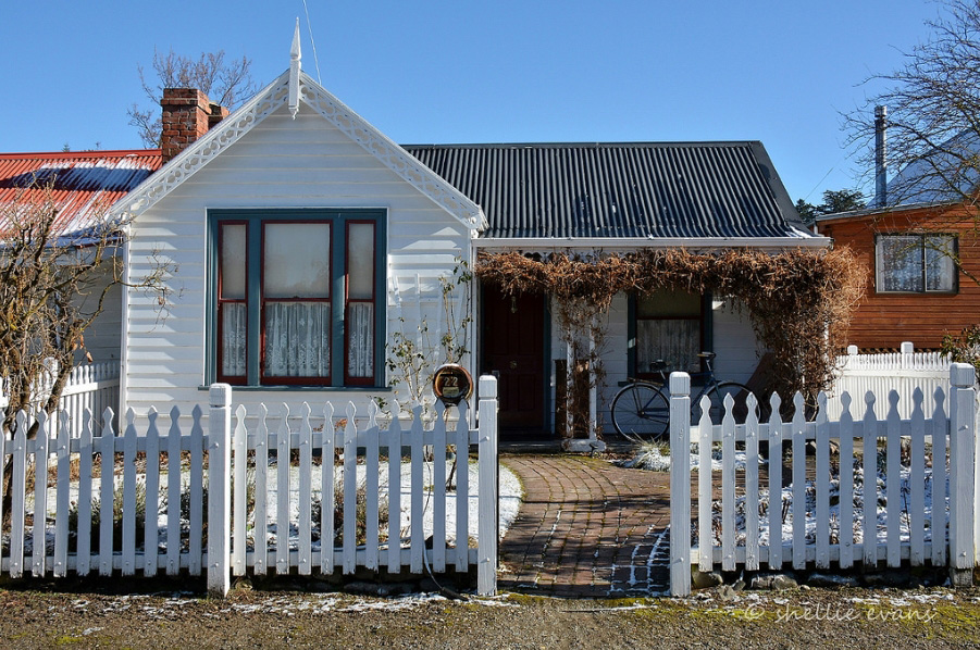
The settlement of Naseby began with the gold rushes of the early 1860s which saw a flood of itinerant miners trying their luck on the Hogburn field on this treeless exposed plain. The town of Naseby was surveyed in 1869 and the 1870s saw the consolidation of the settlement, with the establishment of government services and the erection of more permanent residences such as those constructed by Inder and his business partner William Guffie. Not much is known about the construction of these two cottages but they appear in an 1877 image sitting identically alongside each other on sparsely populated Derwent Street. In the 1880s a bay was added to the Guffie Cottage, and it is in this form that the closely built pair shows the street today.
Walter Inder was a key figure in the town being a miner, businessman and politician active in the Naseby community until his death in 1891. He was in partnership with Scottish born William Guffie who was also a politician and civic leader, being at one point mayor of Naseby, and sold this property to Guffie in 1878.The Inder Cottage remained in the Inder family until 1929 and has seen a number of owners since that time.
The two cottages are timber, typical box form with the services included in long narrow outbuildings to the rear, which are in part constructed using earth, a common building material in the treeless Maniototo. In plan both cottages are typical of small mid Victorian dwellings with a narrow central corridor flanked by small rooms, with the kitchen at the rear.
In 2010 24 Derwent Street (known as Hnaef’s Fort) is a holiday house and remains one of an admired pair, a landmark on the main street of this small Maniototo settlement.

List Entry Information
Status
Listed
List Entry Status
Historic Place Category 2
Access
Private/No Public Access
List Number
3216
Date Entered
15th April 2011
Date of Effect
15th April 2011
City/District Council
Central Otago District
Region
Otago Region
Extent of List Entry
Extent includes the land described as Pt Sec 6 Blk II Town of Naseby (RTs OT96/252), Otago Land District and the building known as Inder Cottage, thereon, and its fittings and fixtures. (Refer to map in Appendix 1 of the registration report for further information).
Legal description
Pt Sec 6 Blk II Town of Naseby (RT OT96/252), Otago Land District
Why is this place significant?
Historic Significance
Historical Significance or Value The Inder and Guffie Cottages represent the period in Naseby’s history when the itinerant goldfield’s population was being replaced by a more settled community. The consolidation of the town can be seen in the construction of more permanent residences, such as these cottages.
Physical Significance
Aesthetic Significance or Value: With its neighbour, Inder Cottage is recognised for the aesthetic contribution to the Naseby townscape. Their diminutive size and close pairing make them significant elements in this former gold mining town, notable for its small scale and its historic streetscape. Architectural Significance or Value: Inder Cottage is representative of the tiny residential dwellings characteristic of the miner’s cottages in gold rush era Naseby and therefore has architectural significance. Both cottages are representative of the typical small cottage dwellings from the Victorian period which, despite some modifications, still provide insight into architecture from this period.
Why is this place Category 1 / Category 2?
Detail Of Assessed Criteria
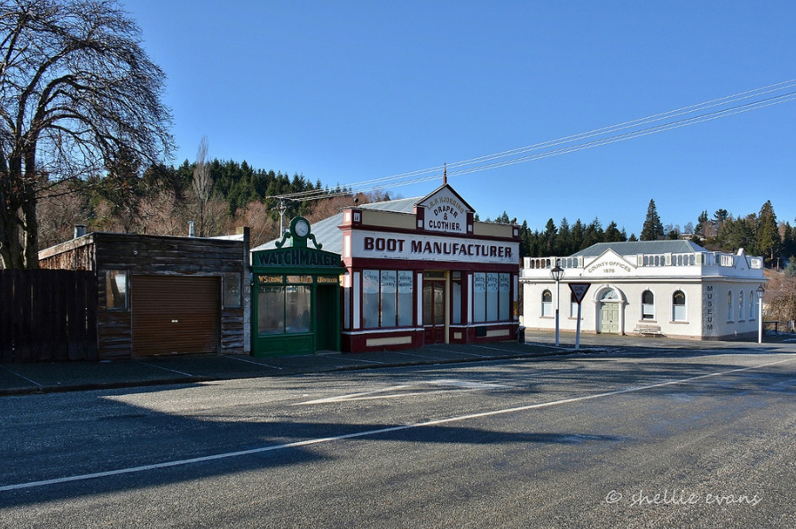
(a) The extent to which the place reflects important or representative aspects of New Zealand history The Inder and Guffie cottages reflect representative aspects of New Zealand history, in particular the transition of Naseby from a frontier settlement to a town. These residences are typical of small cottage dwellings which were, as architect Jeremy Salmond writes the basic unit of housing design throughout the nineteenth century. (b) The association of the place with events, persons, or ideas of importance in New Zealand history The Cottage is associated with Walter Inder who was involved in local politics and was a prominent businessman in this small town. (e) The community association with, or public esteem for the place Both the Inder and Guffie cottages have been identified as an attractive pair in a number of local publications which identify buildings of significance to Naseby’s streetscape. They have also been included within the Naseby Historic Area. They can be said to be held in public esteem. (k) The extent to which the place forms part of a wider historical and cultural complex or historical and cultural landscape The Inder and Guffie Cottages built on the main street close to other notable historic buildings such as the Strong Cottage, the Masonic Hall, former Courthouse and former Post Office are a significant element in the historical townscape of Naseby. Naseby is notable for its historic townscape (recognised by the Naseby Historic Area), which includes much of the historic town centre. The cottages sit on the main street of Naseby and make an important contribution to the town’s wider historic landscape. Summary of Significance or Values This place was assessed against, and found it to qualify under the following criteria: a, b, e and k. Conclusion It is considered that this place qualifies as a Category II historic place.
Why is this place significant?
Historic Significance
Historical Significance or Value The Inder and Guffie Cottages represent the period in Naseby’s history when the itinerant goldfield’s population was being replaced by a more settled community. The consolidation of the town can be seen in the construction of more permanent residences, such as these cottages.
Physical Significance
Aesthetic Significance or Value: With its neighbour, Inder Cottage is recognised for the aesthetic contribution to the Naseby townscape. Their diminutive size and close pairing make them significant elements in this former gold mining town, notable for its small scale and its historic streetscape. Architectural Significance or Value: Inder Cottage is representative of the tiny residential dwellings characteristic of the miner’s cottages in gold rush era Naseby and therefore has architectural significance. Both cottages are representative of the typical small cottage dwellings from the Victorian period which, despite some modifications, still provide insight into architecture from this period.
Why is this place Category 1 / Category 2?
Detail Of Assessed Criteria
(a) The extent to which the place reflects important or representative aspects of New Zealand history The Inder and Guffie cottages reflect representative aspects of New Zealand history, in particular the transition of Naseby from a frontier settlement to a town. These residences are typical of small cottage dwellings which were, as architect Jeremy Salmond writes the basic unit of housing design throughout the nineteenth century. (b) The association of the place with events, persons, or ideas of importance in New Zealand history The Cottage is associated with Walter Inder who was involved in local politics and was a prominent businessman in this small town. (e) The community association with, or public esteem for the place Both the Inder and Guffie cottages have been identified as an attractive pair in a number of local publications which identify buildings of significance to Naseby’s streetscape. They have also been included within the Naseby Historic Area. They can be said to be held in public esteem. (k) The extent to which the place forms part of a wider historical and cultural complex or historical and cultural landscape The Inder and Guffie Cottages built on the main street close to other notable historic buildings such as the Strong Cottage, the Masonic Hall, former Courthouse and former Post Office are a significant element in the historical townscape of Naseby. Naseby is notable for its historic townscape (recognised by the Naseby Historic Area), which includes much of the historic town centre. The cottages sit on the main street of Naseby and make an important contribution to the town’s wider historic landscape. Summary of Significance or Values This place was assessed against, and found it to qualify under the following criteria: a, b, e and k. Conclusion It is considered that this place qualifies as a Category II historic place.
Construction Details
Type
Original Construction
Description
Construction of outbuildings
Period
Unknown
Construction Materials
Baltic Pine, corrugated iron, earth construction, brick
Construction Details
Type
Original Construction
Description
Construction of outbuildings
Period
Unknown
Construction Materials
Baltic Pine, corrugated iron, earth construction, brick
Maori History Maori had settlements in Central Otago, associated with early occupation. Six were known on Lake Hawea (Te Taweha o Hawea, Mahaea, O tu Purupuru, Turihuka, Te Taumanu o Taki and Pakituhi) and one near Cromwell (Wairere). The moa-rich area was known for camps where moa were butchered and cooked (for example there were large sites in the Hawksburn and Happy Valley areas, as well as the Nevis Valley), and there were quarries used for stone tools in the region of Tiger Hills and Mount Benger. Closer to Naseby, the swampy plains in the Maniototo provided eels and other food resources. There are no recorded Maori archaeological sites in Naseby. Naseby The history of gold mining in Central Otago began with Gabriel Read’s discovery of gold in Gabriel’s Gully, near present-day Lawrence, in 1861. The following year Hartley and Reilly left this gully and travelled further into Central Otago. They spent the winter prospecting in the now-flooded Clutha Gorge between present day Clyde and Cromwell, finding enough gold in the area to travel back to Dunedin and lodge 87 pounds with the Gold Receiver. Gold was quickly discovered in other parts of the region, including places such as Hogburn (renamed Naseby in 1874). There were an estimated 78 goldfields in Central Otago, boom towns sprung up to service the gold diggings, and disappeared just as quickly as the gold returns for the itinerant miners. Little remains of these places. Historian John Angus writes ‘[w]hen the miners decamped so too did the commercial section of many of the early towns. This pattern was repeated many times, often at remote locations in Central Otago. But some settlements remained, undergoing a sort of metamorphosis to become service centres for the subsequent stages of more stable mining.’ Towns developed haphazardly. Historian John Angus writes that gold mining towns were often an ‘incongruous jumble of handsome stone hotels and public buildings, ornate shop facades often masking bare corrugated iron sides, and ramshackle tin sheds.’ These were often ‘frontier towns’: ‘hotels, illicit sly-grog shops, gambling booths and what Europeans called the ‘opium dens’ of the Chinese. Over the towns there often remained an air of impermanence.’ Naseby was typical of impermanent impromptu development. This haphazard development was particularly true for Hogburn. The site of the Mt Ida goldfields and the associated township was originally part of a depasturing license, Run 204, called the Sowburn. After the discovery of gold the Otago Provincial Council cancelled the license and proclaimed the Mt. Ida Goldfield. While the original canvas town was set up in the Hogburn Gully, when the official town of Naseby was surveyed it was situated at the mouth of the gully, about a kilometre from the original location. The nascent town was built largely of iron and canvas structures. The suggestion of a new location resulted in angry outbursts and a memorial signed by 350 miners and business people protesting the injustice of such a decision. Businessmen protested that their ability to carry on their trade was dependent on being located near the customers, and there were 150 storekeepers in the existing township, and only 40 allotments surveyed in for businesses in the new survey, let alone that the ground under the new town had not been worked and was likely to be auriferous. Despite objections the town was established in the new location. The town of Naseby grew steadily with the fortunes of its gold miner population during the 1860s and 1870s. Even in these early years Naseby was seen as the quintessential goldfields town. A correspondent for the Timaru Herald wrote in 1874 that it was ‘one of best specimens, I should say, of a goldfield town; on all sides, in the streets themselves, round the very church which is perched up on a bit of ground only just preserved sacred from the pick and shovel, there are signs of the destructive miner. Acres of land turned over in all directions and the muddy waters of tailraces running down the main thoroughfares, present altogether a curious picture, not the less odd by the funny collection of the small sheet iron shanties which for the most part make up Naseby.’ There were eighteen public houses at this time. Much ground was worked within the township and had been washed away, reoccupied by residences later. There was a lull in mining in the mid 1870s in the period prior to the building of the Mt Ida Water Race and the Hogburn Sludge Channel. Inder and Guffie’s Houses Unlike other areas of the country where a plentiful supply of timber provided for a range of construction methods and materials, Maniototo was treeless and therefore timber had to be sourced from outside the area. In such areas kitset buildings were known, for example the Church of St Alban the Martyr at St Bathans was sent from England as a kitset, timber framed with corrugated iron cladding. Imported houses could be sent ‘in frame’ with the framing cut to length. Imported timbers were also available including Baltic pine. By 1860 in many places in New Zealand, architect Jeremy Salmond writes, the ‘small timber house had become established as the New Zealand vernacular dwelling’ and the ‘little wooden cottage’ formed the base from which other house designs sprang. In developing towns, where the surveyor had laid out the streets, cottages usually turned their faces to the road, as these two small dwellings do in Naseby. The small cottage of ‘one or two rooms, with a central door and a window either side of the door, remained the basic unit of ordinary house design throughout the nineteenth century.’ The basic ‘box cottage’ could be modified to provide variation, the most common additions being a verandah or a lean-to. These basic forms in their various combinations led to a wealth of variations and could easily be enlarged. The addition of a verandah was ‘a feature of any house with pretensions to style.’ The box cottages are, as Salmond writes of the Victorian period, ‘an exact impression of their time, and of the lives that were lived in them,’ and in Naseby at this time these two cottages, much as they look small to our eyes were relatively substantial dwellings compared to the primitive residences in which many miners lived. In four room cottages the basic plan was that the two front rooms were the parlour and best bedroom, with the kitchen and another bedroom at the rear. The passage from the front door led to the kitchen at the rear. Outhouses for other services were often in separate buildings out the back of the house. It has been recorded that these two cottages were kit sets erected for the government as accommodation for the Commissioner for the Goldfields and his assistant in the late 1860s or the early 1870s. Research to date has not been able to confirm this assertion, and it does not seem to match the early land title information for the properties. The Goldfields commissioner was not resident in Naseby. It has also been said that the Baltic pine cottages were shipped out in kitset form in the 1860s. The date seems unlikely because they follow the alignment of the part sections exactly but the kit set theory is possible. The township of Naseby was surveyed in 1869, and it is likely that the cottages were built after the survey as the building footprints match the section outline. Buildings built before the town was surveyed in 1869 tend not to follow the parcel boundaries. The land on which the cottages are built was first granted to slaughterman Walter Inder in October 1871. A panorama of Naseby taken around 1877 (the courthouse has been constructed), shows the two cottages sitting alongside each other on the sparsely built Derwent Street. They are identical in form, down to the fencing on the north side of each section. Nearby residences are more haphazardly placed but equally diminutive. The brick chimney for each house marks the boundary of the part sections. This date of construction links the two cottages to Walter Inder’s sole ownership up to 1878. Walter Inder was one a ‘vigorous group of go ahead men’ who worked with the community to provide services and amenities. Inder was involved in many community institutions, including civic and church affairs. With his brother Samuel he was partners in the firm of Inders Bros., butchers, which had branches in the Maniototo. Inder transferred part of the land to William Guffie in January 1878, and a new title was issued with both men as registered proprietors, subdividing Section 6 into two parts, with 22 Derwent Street becoming Guffie’s property. William Guffie and Inder were business partners, and related by marriage. William Guffie was manager of Inder and Guffie’s Hydraulic Sluicing Works at Mount Burster, close to Naseby. Walter Inder died in July 1891 and the land on which 24 Derwent stands was transferred to Robert Inder and Frederick Inder in 1893. The property remained in the property of the Inder family (as ‘tenants in common’) until 1929 when Agnes Mary Churchill wife of Naseby carpenter John Churchill bought it. On Churchill’s death in the 1950s Ethel Cunningham took over the property and it remained in the Cunningham family until the 1970s. After several changes of ownership through the 1980s and 1990s the current owners bought the property in 2002 and it is used as a holiday house. During the alterations to 22 Derwent Street Mr Broadley noted that the studs were square dowelled into the roof plates, and that the original roofing iron was screwed rather than nailed into place. These building methods have been used to argue that the cottages were constructed as kitsets. In 1993 the ‘two artisans cottages’ were included in Brian Frazer’s work ‘Naseby Notebook - An elementary guide to Naseby’s historic and scenic features’. Frazer identifies the cottages (and includes a line drawing of the pair) as among the ‘important old structures’ that can be seen on Derwent Street, which has the ‘greatest concentration of both civic and private structures’ in the town. The pair are included in the Naseby Historic Area registered by NZ Historic Places Trust in 1996 (Record No. 7365). In 2010 24 Derwent Street (known as Hnaef’s fort) remains a holiday house used in the weekends. They remain an admired pair, a landmark on the main street of this small Maniototo settlement.
Maori History Maori had settlements in Central Otago, associated with early occupation. Six were known on Lake Hawea (Te Taweha o Hawea, Mahaea, O tu Purupuru, Turihuka, Te Taumanu o Taki and Pakituhi) and one near Cromwell (Wairere). The moa-rich area was known for camps where moa were butchered and cooked (for example there were large sites in the Hawksburn and Happy Valley areas, as well as the Nevis Valley), and there were quarries used for stone tools in the region of Tiger Hills and Mount Benger. Closer to Naseby, the swampy plains in the Maniototo provided eels and other food resources. There are no recorded Maori archaeological sites in Naseby. Naseby The history of gold mining in Central Otago began with Gabriel Read’s discovery of gold in Gabriel’s Gully, near present-day Lawrence, in 1861. The following year Hartley and Reilly left this gully and travelled further into Central Otago. They spent the winter prospecting in the now-flooded Clutha Gorge between present day Clyde and Cromwell, finding enough gold in the area to travel back to Dunedin and lodge 87 pounds with the Gold Receiver. Gold was quickly discovered in other parts of the region, including places such as Hogburn (renamed Naseby in 1874). There were an estimated 78 goldfields in Central Otago, boom towns sprung up to service the gold diggings, and disappeared just as quickly as the gold returns for the itinerant miners. Little remains of these places. Historian John Angus writes ‘[w]hen the miners decamped so too did the commercial section of many of the early towns. This pattern was repeated many times, often at remote locations in Central Otago. But some settlements remained, undergoing a sort of metamorphosis to become service centres for the subsequent stages of more stable mining.’ Towns developed haphazardly. Historian John Angus writes that gold mining towns were often an ‘incongruous jumble of handsome stone hotels and public buildings, ornate shop facades often masking bare corrugated iron sides, and ramshackle tin sheds.’ These were often ‘frontier towns’: ‘hotels, illicit sly-grog shops, gambling booths and what Europeans called the ‘opium dens’ of the Chinese. Over the towns there often remained an air of impermanence.’ Naseby was typical of impermanent impromptu development. This haphazard development was particularly true for Hogburn. The site of the Mt Ida goldfields and the associated township was originally part of a depasturing license, Run 204, called the Sowburn. After the discovery of gold the Otago Provincial Council cancelled the license and proclaimed the Mt. Ida Goldfield. While the original canvas town was set up in the Hogburn Gully, when the official town of Naseby was surveyed it was situated at the mouth of the gully, about a kilometre from the original location. The nascent town was built largely of iron and canvas structures. The suggestion of a new location resulted in angry outbursts and a memorial signed by 350 miners and business people protesting the injustice of such a decision. Businessmen protested that their ability to carry on their trade was dependent on being located near the customers, and there were 150 storekeepers in the existing township, and only 40 allotments surveyed in for businesses in the new survey, let alone that the ground under the new town had not been worked and was likely to be auriferous. Despite objections the town was established in the new location. The town of Naseby grew steadily with the fortunes of its gold miner population during the 1860s and 1870s. Even in these early years Naseby was seen as the quintessential goldfields town. A correspondent for the Timaru Herald wrote in 1874 that it was ‘one of best specimens, I should say, of a goldfield town; on all sides, in the streets themselves, round the very church which is perched up on a bit of ground only just preserved sacred from the pick and shovel, there are signs of the destructive miner. Acres of land turned over in all directions and the muddy waters of tailraces running down the main thoroughfares, present altogether a curious picture, not the less odd by the funny collection of the small sheet iron shanties which for the most part make up Naseby.’ There were eighteen public houses at this time. Much ground was worked within the township and had been washed away, reoccupied by residences later. There was a lull in mining in the mid 1870s in the period prior to the building of the Mt Ida Water Race and the Hogburn Sludge Channel. Inder and Guffie’s Houses Unlike other areas of the country where a plentiful supply of timber provided for a range of construction methods and materials, Maniototo was treeless and therefore timber had to be sourced from outside the area. In such areas kitset buildings were known, for example the Church of St Alban the Martyr at St Bathans was sent from England as a kitset, timber framed with corrugated iron cladding. Imported houses could be sent ‘in frame’ with the framing cut to length. Imported timbers were also available including Baltic pine. By 1860 in many places in New Zealand, architect Jeremy Salmond writes, the ‘small timber house had become established as the New Zealand vernacular dwelling’ and the ‘little wooden cottage’ formed the base from which other house designs sprang. In developing towns, where the surveyor had laid out the streets, cottages usually turned their faces to the road, as these two small dwellings do in Naseby. The small cottage of ‘one or two rooms, with a central door and a window either side of the door, remained the basic unit of ordinary house design throughout the nineteenth century.’ The basic ‘box cottage’ could be modified to provide variation, the most common additions being a verandah or a lean-to. These basic forms in their various combinations led to a wealth of variations and could easily be enlarged. The addition of a verandah was ‘a feature of any house with pretensions to style.’ The box cottages are, as Salmond writes of the Victorian period, ‘an exact impression of their time, and of the lives that were lived in them,’ and in Naseby at this time these two cottages, much as they look small to our eyes were relatively substantial dwellings compared to the primitive residences in which many miners lived. In four room cottages the basic plan was that the two front rooms were the parlour and best bedroom, with the kitchen and another bedroom at the rear. The passage from the front door led to the kitchen at the rear. Outhouses for other services were often in separate buildings out the back of the house. It has been recorded that these two cottages were kit sets erected for the government as accommodation for the Commissioner for the Goldfields and his assistant in the late 1860s or the early 1870s. Research to date has not been able to confirm this assertion, and it does not seem to match the early land title information for the properties. The Goldfields commissioner was not resident in Naseby. It has also been said that the Baltic pine cottages were shipped out in kitset form in the 1860s. The date seems unlikely because they follow the alignment of the part sections exactly but the kit set theory is possible. The township of Naseby was surveyed in 1869, and it is likely that the cottages were built after the survey as the building footprints match the section outline. Buildings built before the town was surveyed in 1869 tend not to follow the parcel boundaries. The land on which the cottages are built was first granted to slaughterman Walter Inder in October 1871. A panorama of Naseby taken around 1877 (the courthouse has been constructed), shows the two cottages sitting alongside each other on the sparsely built Derwent Street. They are identical in form, down to the fencing on the north side of each section. Nearby residences are more haphazardly placed but equally diminutive. The brick chimney for each house marks the boundary of the part sections. This date of construction links the two cottages to Walter Inder’s sole ownership up to 1878. Walter Inder was one a ‘vigorous group of go ahead men’ who worked with the community to provide services and amenities. Inder was involved in many community institutions, including civic and church affairs. With his brother Samuel he was partners in the firm of Inders Bros., butchers, which had branches in the Maniototo. Inder transferred part of the land to William Guffie in January 1878, and a new title was issued with both men as registered proprietors, subdividing Section 6 into two parts, with 22 Derwent Street becoming Guffie’s property. William Guffie and Inder were business partners, and related by marriage. William Guffie was manager of Inder and Guffie’s Hydraulic Sluicing Works at Mount Burster, close to Naseby. Walter Inder died in July 1891 and the land on which 24 Derwent stands was transferred to Robert Inder and Frederick Inder in 1893. The property remained in the property of the Inder family (as ‘tenants in common’) until 1929 when Agnes Mary Churchill wife of Naseby carpenter John Churchill bought it. On Churchill’s death in the 1950s Ethel Cunningham took over the property and it remained in the Cunningham family until the 1970s. After several changes of ownership through the 1980s and 1990s the current owners bought the property in 2002 and it is used as a holiday house. During the alterations to 22 Derwent Street Mr Broadley noted that the studs were square dowelled into the roof plates, and that the original roofing iron was screwed rather than nailed into place. These building methods have been used to argue that the cottages were constructed as kitsets. In 1993 the ‘two artisans cottages’ were included in Brian Frazer’s work ‘Naseby Notebook - An elementary guide to Naseby’s historic and scenic features’. Frazer identifies the cottages (and includes a line drawing of the pair) as among the ‘important old structures’ that can be seen on Derwent Street, which has the ‘greatest concentration of both civic and private structures’ in the town. The pair are included in the Naseby Historic Area registered by NZ Historic Places Trust in 1996 (Record No. 7365). In 2010 24 Derwent Street (known as Hnaef’s fort) remains a holiday house used in the weekends. They remain an admired pair, a landmark on the main street of this small Maniototo settlement.
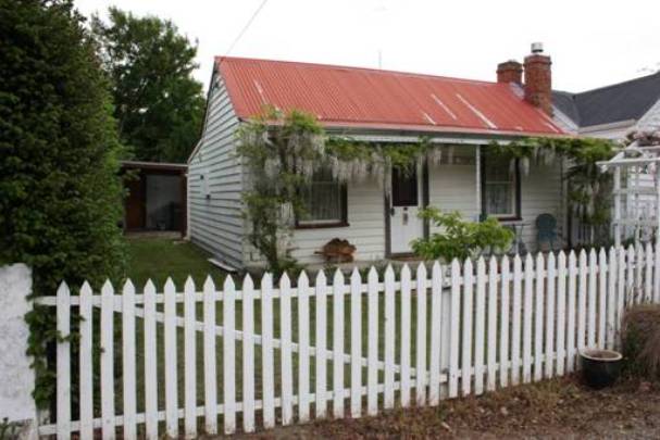
Setting These two closely connected cottages sit on the west side of Derwent Street, the main street of the small Maniototo town of Naseby. On the south side of 24 Derwent Street was the original school ground, now occupied by a new lodge style accommodation development. 22 Derwent Street has an empty section on its northern boundary, and a house on its east boundary. Across Derwent Street is the similarly diminutive cottage built by members of the well known Strong family. On the next block are the former Masonic Lodge, Courthouse and the Naseby Post Office. Along with the pair of cottages this is a significant streetscape in Naseby. The cottages sit on long narrow sections, more typical of an urban setting than the haphazard layout characteristic of Naseby’s residential development. The cottages have the appearance of semi-detached residences. Their walls abut each other and their brick chimney breasts share the boundary line, nestled next to each other. Their outbuildings appear to share a common rear wall. 24 Derwent Street 24 Derwent Street is a single storey single-gable cottage with a veranda across the front and a cat-slide roof at the rear. The main elevation has a central door and is flanked by single double-hung sash windows. The front door has timber panels and coloured glass inserts. The exterior brick chimney breast sits between the buildings, sharing the boundary, with just the single depth of a chimney separating the houses. There are no windows on the south elevation. The rear elevation has two sets of small windows with a central door leading directly into the tiny kitchen. Although the interior was not visited for the preparation of this report, the layout remains original with a narrow central corridor with rooms off. According to NZHPT records the wall between one of the front rooms and the hall has been removed to make a larger living space. Along the northern boundary there is a long thin skillion-roofed out-building; connected to the main body of the cottage only by the roof (the alcove contains a washing machine). There is a fibrolite garage on the southern boundary.
Setting These two closely connected cottages sit on the west side of Derwent Street, the main street of the small Maniototo town of Naseby. On the south side of 24 Derwent Street was the original school ground, now occupied by a new lodge style accommodation development. 22 Derwent Street has an empty section on its northern boundary, and a house on its east boundary. Across Derwent Street is the similarly diminutive cottage built by members of the well known Strong family. On the next block are the former Masonic Lodge, Courthouse and the Naseby Post Office. Along with the pair of cottages this is a significant streetscape in Naseby. The cottages sit on long narrow sections, more typical of an urban setting than the haphazard layout characteristic of Naseby’s residential development. The cottages have the appearance of semi-detached residences. Their walls abut each other and their brick chimney breasts share the boundary line, nestled next to each other. Their outbuildings appear to share a common rear wall. 24 Derwent Street 24 Derwent Street is a single storey single-gable cottage with a veranda across the front and a cat-slide roof at the rear. The main elevation has a central door and is flanked by single double-hung sash windows. The front door has timber panels and coloured glass inserts. The exterior brick chimney breast sits between the buildings, sharing the boundary, with just the single depth of a chimney separating the houses. There are no windows on the south elevation. The rear elevation has two sets of small windows with a central door leading directly into the tiny kitchen. Although the interior was not visited for the preparation of this report, the layout remains original with a narrow central corridor with rooms off. According to NZHPT records the wall between one of the front rooms and the hall has been removed to make a larger living space. Along the northern boundary there is a long thin skillion-roofed out-building; connected to the main body of the cottage only by the roof (the alcove contains a washing machine). There is a fibrolite garage on the southern boundary.
Historical and Associated Iwi / Hapū / Whānau
Completion Date
15th December 2010
Report Written By
Heather Bauchop
Information Sources
Cyclopedia of New Zealand, 1905
Cyclopedia Company, Industrial, descriptive, historical, biographical facts, figures, illustrations, Wellington, N.Z, 1897-1908, Vol. 4 Otago and Southland, Cyclopedia Company, Christchurch, 1905
Hamel, 1985
J Hamel, Gold miners and their landscape at Naseby. NZ Forest Service, 1985.
O'Neill, 1976
J O'Neill. The History of Naseby. Naseby 1976.
Salmond, 1986
Jeremy Salmond, Old New Zealand Houses 1800-1940, Auckland, 1986, Reed Methuen
Thompson, 1949
Helen Thompson, East of the Rock and Pillar: A History of the Strath Taieri and Macraes District, Otago Centennial Historical Publications, Dunedin, 1949
Other Information
A fully referenced registration report is available from the NZHPT Otago/Southland Area office Please note that entry on the New Zealand Heritage List/Rarangi Korero identifies only the heritage values of the property concerned, and should not be construed as advice on the state of the property, or as a comment of its soundness or safety, including in regard to earthquake risk, safety in the event of fire, or insanitary conditions.
Current Usages
Uses: Accommodation
Specific Usage: House
Former Usages
General Usage: Accommodation
Specific Usage: House
Current Usages
Uses: Accommodation
Specific Usage: House
Former Usages
General Usage: Accommodation
Specific Usage: House
Location
Related listings
Sign up to hear more
Get the latest heritage news, features and events delivered
straight to your inbox.
