The Coronation Sea Wall and the development of Devonport:
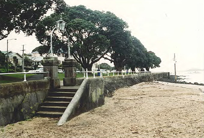
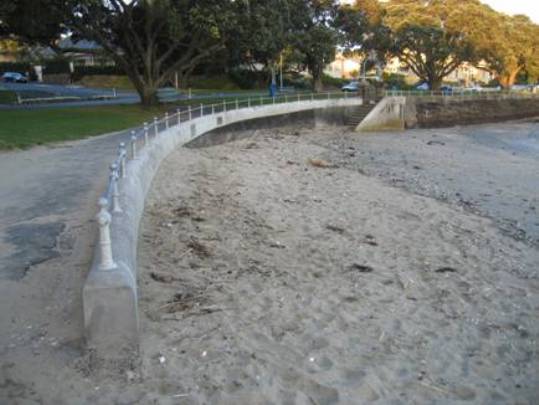
The Coronation Sea Wall in Devonport, Auckland, is closely linked with civic moves to celebrate notable events in early twentieth-century New Zealand, such as the coronation of British monarchs and the end of the Second Boer War (1899-1902), and to provide practical amenities of local benefit. Forming a revetment along the seaside esplanade at King Edward Parade, the scoria concrete wall was erected in two stages by the Devonport Borough Council, in 1902-1903 and 1912. The Council was at the forefront of improving civic facilities along the Devonport foreshore from its foundation in 1886. The foreshore, and its associated walls, effectively formed the 'front door' to Devonport, with ferries being virtually the only means of travel to and from Auckland.
From an early stage in the colonial history of Auckland, Devonport had held a prominent military and maritime role in the region. Located on the northern shore of the Waitemata Harbour, it was home to the main British Naval base in New Zealand, and a centre for boatbuilding and maritime surveying. By the early 1900s, the settlement had developed into a prosperous seaside community, with an emerging reputation as a recreational resort, accessible by ferry from Auckland. Demand grew for civic amenities that facilitated particular forms of recreation, such as genteel site-seeing and perambulation. Seaside resorts such as Devonport gained considerably in popularity in late nineteenth- and early twentieth-century New Zealand, partly due to the rise of urban populations - as at nearby Auckland - and a widespread belief in the health and other benefits of fresh sea air.
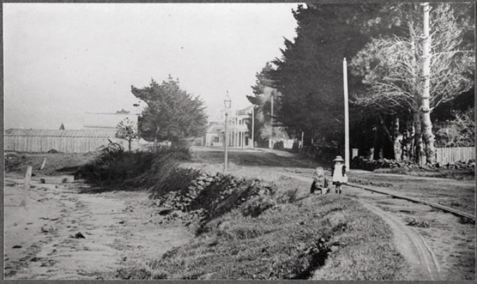
Administrative control over the foreshore in Devonport had been a longstanding issue for the Borough Council. A thoroughfare along the shoreline, initially known as Beach Road (later King Edward Parade and Queen's Parade), was surveyed in 1850 with construction of the carriageway commencing in 1870. In May 1886, a year-and-a-half after Devonport's gazetting as a borough, the Council unsuccessfully petitioned the colonial Governor to have the Borough boundaries extended to low water mark so as to include the foreshore from North Head to the Calliope Dock. The Borough desired to regulate the deposition of waste and construction of buildings along the shoreline, and to be able to collect rates for structures that had already been provided with leases by the Auckland Harbour Board. However, control formally remained with the Auckland Harbour Board until 1918, although the council began to erect sea walls perhaps partly as a way of ordering and controlling foreshore activity nearer the high tide mark. The earliest sea walls constructed by the Council appear to have been erected in the 1890s or before.
Initial construction of the Coronation Sea Wall (1902-1903):
Started in 1902, the Coronation Sea Wall formed the earliest stage of an extensive shoreline revetment, stretching over 1 km to the east of Windsor Reserve (formerly Admiralty Reserve), which lay close to the commercial and administrative heart of early twentieth-century Devonport in Victoria Road. As well as regulating activities along the foreshore, the wall facilitated the improvement and beautification of its associated esplanade through the planting of trees and provision of better views across the Waitemata Harbour. The broader project was to take some thirty years, with additions being added incrementally in an eastward direction. Those works occurring after 1912 are not included as part of this registration proposal.
Construction of the first part of the Coronation Sea Wall was closely linked with civic commemoration of the coronation of Edward VII and the cessation of hostilities in the South African - or Second Boer - War. Work appears to have been underway by July/August 1902, although a flight of steps may have already been in existence. On 9 August 1902, the coronation day of King Edward VII, a procession accompanied by a brass band made its way from Devonport's Holy Trinity Church - where a service had been held - to unveil twin inscriptions beside the steps marking the coronation and 'Peace in South Africa'. The unveiling was carried out by Devonport Mayor E.W. Alison (1852-1945), a prominent local politician and founder of the highly successful Devonport Ferry Company. References on the inscriptions to the esplanade being called King Edward Parade are linked to the renaming of the thoroughfare from Beach Road as a further act of commemoration.
Of the £400 spent by the Council on the coronation event, £300 was set aside for the erection of a sea wall. The total attracted a Government subsidy of £200, indicating official encouragement for such projects. The coronation of Edward VII was the first such event to have occurred since the foundation of New Zealand as a British colony, Queen Victoria having ruled for over 60 years. The early 1900s also marked a high point in imperial ties between Britain and New Zealand.
The commemoration of peace in South Africa appears to have been a spontaneous gesture on the part of the Council, which would have learned, on 1 June 1902, of the end of the Second Boer War in which 6,500 New Zealand volunteers had been involved as part of the British imperial effort. At the unveiling, Mayor Alison conferred the silver Imperial meritorious service medal upon a sergeant of the permanent militia, and presented a medal to a Colour-Sergeant of the Devonport District School Cadets, the winner of a bayonet exercise competition. Opening ceremonies for Boer War monuments throughout New Zealand reflected outpourings of pride about the colony's role in the British Empire, and generally made their imperial and military purposes explicit. The association of a war memorial with a utilitarian structure at Devonport was unusual as this was generally considered to diminish its sacred purpose. Criticism may have been offset by references on the Devonport memorial to the celebration of peace, rather than to the war itself.
Following the unveiling ceremony, the Council vigorously proceeded with construction of the Coronation Sea Wall proper, continuing it as far as the means at its command enabled it to be carried out. A decision was taken in mid December 1902 to stop the wall at the steps opposite what is now 5 King Edward Parade and to complete the coping and plastering, leaving extension of the eastern end for further consideration. Construction work was supervised by the Devonport Borough Council foreman of works Charles Savage (c.1847-1924), and is likely to have been carried out by Devonport Borough staff.
The structure appears to be an early example of scoria concrete construction for a sea wall in New Zealand, and pre-dates the more substantial, reinforced concrete construction of wharves in Auckland by several years. The form of the memorial reflects the difficult financial circumstances experienced by the Council at the time. Other than the Malmesbury stone used for the commemorative inscriptions - which was imported from Victoria - the main materials in the sea wall were readily to hand. The Council had a ready supply of scoria, having purchased Mt Cambria in January 1900 at a cost of £3,500. Council staff numbers had to be reduced in June 1901, casualties of economies made to service an £8,000 loan raised a year earlier to pay for public works and the Mt Cambria land.
Early in January 1903, Massey Brothers' tender for 90 standards to adorn the handrail of the seawall was accepted. A month later the Council accepted the gift of a Mr W.A. Jenny - a handsome frame lamp to be placed over the commemorative steps. The lamp does not appear in a photograph published in July 1925. However, a lamp above the pedestals may be visible in a photo taken prior to 1919-1920, suggesting that the structure was removed in the early 1920s.
Extension of the Coronation Sea Wall (1912):
The standards on the sea wall were painted in 1905, but within five years of construction the foot of the sea wall was being worn away in places, and was repaired with cement concrete. Any thoughts of extending the wall further to the east were thwarted by a ratepayer poll in September 1907 that voted against a proposal to raise ₤1,000 for this purpose. A special meeting of Council convened on 17 March 1911 decided that the 'Old Coronation Wall' should be extended to commemorate the forthcoming coronation of King George V, with the laying of a foundation stone as a principal item in Devonport's celebrations. At this time there was a developing awareness of the importance of town planning and urban design projects. In mid-May consulting engineer Lockie Gannon suggested that a straight promenade should be developed - to reduce the distance to the wharf - rather than continuing the wall on its existing path.
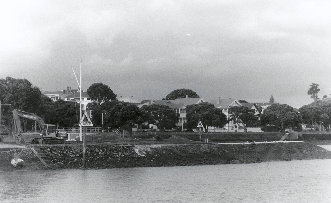
Plans for construction of any sea wall to commemorate the coronation came to a halt later that month, however, when the Minister of Internal Affairs advised that the project was not 'considered to be quite a suitable commemoration of the coronation'. Projects such as town halls, libraries, swimming baths, fountains, avenues of trees and band rotundas were suggested as more suitable monuments for coronation subsidies. In the event, the Borough decided in April the following year, to extend the wall on King Edward Parade without the benefit of subsidy, having in the meantime commemorated King George's coronation on 16 November 1911 with the opening of a band rotunda on Windsor Reserve. Significantly, the extension to the earlier sea wall continued the same vertical design of the original structure, and similarly employed scoria concrete. Construction was supervised by a Mr Wykes, Foreman of Works for the Devonport Borough Council, and carried out by G.H. Lovering. The distinctive design of the 1912 (and 1902-1903) wall contrasts with the sloping construction of later revetments along King Edward Parade - not included in this registration proposal - which were largely completed by 1929.
Subsequent modifications to the Coronation Sea Wall have included local repairs and the provision of a wrought iron arch with lamp, funded by residual money from a bequest made by local businessman A.R.D. Watson in 1917. A memorial to Watson - erected by the Devonport Borough Council in 1936 - is located further east along King Edward Parade. The arch was designed by Councillor R.H.S. Keely, and was erected in 1977 spanning the commemorative pedestals, giving the memorial its current form. The sea wall continues to function as a revetment to the popular esplanade along King Edward Parade, providing access to recreational activities on the beach and rocky foreshore.
Comparisons:
Comparatively few sea walls have been registered by the New Zealand Historic Places Trust, apart from the Otago Harbour Walls at Taiaroa, Dunedin and Aramoana (NZHPT Registration # 4726, Category I historic place), and the Stone Wall (in front of former Rowing Club) at Wakefiled Quay, Nelson (NZHPT Registration # 3026, Category II historic place).
Both Hokitika and Marton have memorials combining the declaration of peace in South Africa with the coronation of Edward VII. Catch-all memorials combining tributes to the Second Boer War dead with commemoration of the coronation include examples at Greymouth, Motueka and Ashburton. The only monument currently on the Register of historic places, historic areas, wahi tapu and wahi tapu areas to jointly mark the Second Boer War and coronation is the Boer War Memorial at Cooks Gardens Reserve, St Hill Street Wanganui (NZHPT Registration # 972, Category II historic place).
Other registered Boer War Memorials are located in Albert Park, Auckland (NZHPT Registration # 556, Category II historic place); Marshland Hill Reserve, New Plymouth (NZHPT Registration # 845, Category II historic place); Memorial Avenue, Timaru (NZHPT Registration # 2046, Category II historic place); Thames Street, Oamaru (NZHPT Registration # 2273, Category II historic place); and Victoria Park, Thames (NZHPT Registration # 4610, Category II historic place). Memorials commemorating the coronation of Edward VII include a Memorial Lamp, Arrowtown (NZHPT Registration # 2107, Category II historic place); the King Edward Park Gates, Hawera (NZHPT Registration # 855, Category II historic place); and the King Edward Technical College (Former), Dunedin (NZHPT Registration # 4712, Category I historic place).
The Coronation Sea Wall in Devonport, Auckland, is closely linked with civic moves to celebrate notable events in early twentieth-century New Zealand, such as the coronation of British monarchs and the end of the Second Boer War (1899-1902), and to provide practical amenities of local benefit. Forming a revetment along the seaside esplanade at King Edward Parade, the scoria concrete wall was erected in two stages by the Devonport Borough Council, in 1902-1903 and 1912. The Council was at the forefront of improving civic facilities along the Devonport foreshore from its foundation in 1886. The foreshore, and its associated walls, effectively formed the 'front door' to Devonport, with ferries being virtually the only means of travel to and from Auckland.
From an early stage in the colonial history of Auckland, Devonport had held a prominent military and maritime role in the region. Located on the northern shore of the Waitemata Harbour, it was home to the main British Naval base in New Zealand, and a centre for boatbuilding and maritime surveying. By the early 1900s, the settlement had developed into a prosperous seaside community, with an emerging reputation as a recreational resort, accessible by ferry from Auckland. Demand grew for civic amenities that facilitated particular forms of recreation, such as genteel site-seeing and perambulation. Seaside resorts such as Devonport gained considerably in popularity in late nineteenth- and early twentieth-century New Zealand, partly due to the rise of urban populations - as at nearby Auckland - and a widespread belief in the health and other benefits of fresh sea air.
Administrative control over the foreshore in Devonport had been a longstanding issue for the Borough Council. A thoroughfare along the shoreline, initially known as Beach Road (later King Edward Parade and Queen's Parade), was surveyed in 1850 with construction of the carriageway commencing in 1870. In May 1886, a year-and-a-half after Devonport's gazetting as a borough, the Council unsuccessfully petitioned the colonial Governor to have the Borough boundaries extended to low water mark so as to include the foreshore from North Head to the Calliope Dock. The Borough desired to regulate the deposition of waste and construction of buildings along the shoreline, and to be able to collect rates for structures that had already been provided with leases by the Auckland Harbour Board. However, control formally remained with the Auckland Harbour Board until 1918, although the council began to erect sea walls perhaps partly as a way of ordering and controlling foreshore activity nearer the high tide mark. The earliest sea walls constructed by the Council appear to have been erected in the 1890s or before.
Initial construction of the Coronation Sea Wall (1902-1903):
Started in 1902, the Coronation Sea Wall formed the earliest stage of an extensive shoreline revetment, stretching over 1 km to the east of Windsor Reserve (formerly Admiralty Reserve), which lay close to the commercial and administrative heart of early twentieth-century Devonport in Victoria Road. As well as regulating activities along the foreshore, the wall facilitated the improvement and beautification of its associated esplanade through the planting of trees and provision of better views across the Waitemata Harbour. The broader project was to take some thirty years, with additions being added incrementally in an eastward direction. Those works occurring after 1912 are not included as part of this registration proposal.
Construction of the first part of the Coronation Sea Wall was closely linked with civic commemoration of the coronation of Edward VII and the cessation of hostilities in the South African - or Second Boer - War. Work appears to have been underway by July/August 1902, although a flight of steps may have already been in existence. On 9 August 1902, the coronation day of King Edward VII, a procession accompanied by a brass band made its way from Devonport's Holy Trinity Church - where a service had been held - to unveil twin inscriptions beside the steps marking the coronation and 'Peace in South Africa'. The unveiling was carried out by Devonport Mayor E.W. Alison (1852-1945), a prominent local politician and founder of the highly successful Devonport Ferry Company. References on the inscriptions to the esplanade being called King Edward Parade are linked to the renaming of the thoroughfare from Beach Road as a further act of commemoration.
Of the £400 spent by the Council on the coronation event, £300 was set aside for the erection of a sea wall. The total attracted a Government subsidy of £200, indicating official encouragement for such projects. The coronation of Edward VII was the first such event to have occurred since the foundation of New Zealand as a British colony, Queen Victoria having ruled for over 60 years. The early 1900s also marked a high point in imperial ties between Britain and New Zealand.
The commemoration of peace in South Africa appears to have been a spontaneous gesture on the part of the Council, which would have learned, on 1 June 1902, of the end of the Second Boer War in which 6,500 New Zealand volunteers had been involved as part of the British imperial effort. At the unveiling, Mayor Alison conferred the silver Imperial meritorious service medal upon a sergeant of the permanent militia, and presented a medal to a Colour-Sergeant of the Devonport District School Cadets, the winner of a bayonet exercise competition. Opening ceremonies for Boer War monuments throughout New Zealand reflected outpourings of pride about the colony's role in the British Empire, and generally made their imperial and military purposes explicit. The association of a war memorial with a utilitarian structure at Devonport was unusual as this was generally considered to diminish its sacred purpose. Criticism may have been offset by references on the Devonport memorial to the celebration of peace, rather than to the war itself.
Following the unveiling ceremony, the Council vigorously proceeded with construction of the Coronation Sea Wall proper, continuing it as far as the means at its command enabled it to be carried out. A decision was taken in mid December 1902 to stop the wall at the steps opposite what is now 5 King Edward Parade and to complete the coping and plastering, leaving extension of the eastern end for further consideration. Construction work was supervised by the Devonport Borough Council foreman of works Charles Savage (c.1847-1924), and is likely to have been carried out by Devonport Borough staff.
The structure appears to be an early example of scoria concrete construction for a sea wall in New Zealand, and pre-dates the more substantial, reinforced concrete construction of wharves in Auckland by several years. The form of the memorial reflects the difficult financial circumstances experienced by the Council at the time. Other than the Malmesbury stone used for the commemorative inscriptions - which was imported from Victoria - the main materials in the sea wall were readily to hand. The Council had a ready supply of scoria, having purchased Mt Cambria in January 1900 at a cost of £3,500. Council staff numbers had to be reduced in June 1901, casualties of economies made to service an £8,000 loan raised a year earlier to pay for public works and the Mt Cambria land.
Early in January 1903, Massey Brothers' tender for 90 standards to adorn the handrail of the seawall was accepted. A month later the Council accepted the gift of a Mr W.A. Jenny - a handsome frame lamp to be placed over the commemorative steps. The lamp does not appear in a photograph published in July 1925. However, a lamp above the pedestals may be visible in a photo taken prior to 1919-1920, suggesting that the structure was removed in the early 1920s.
Extension of the Coronation Sea Wall (1912):
The standards on the sea wall were painted in 1905, but within five years of construction the foot of the sea wall was being worn away in places, and was repaired with cement concrete. Any thoughts of extending the wall further to the east were thwarted by a ratepayer poll in September 1907 that voted against a proposal to raise ₤1,000 for this purpose. A special meeting of Council convened on 17 March 1911 decided that the 'Old Coronation Wall' should be extended to commemorate the forthcoming coronation of King George V, with the laying of a foundation stone as a principal item in Devonport's celebrations. At this time there was a developing awareness of the importance of town planning and urban design projects. In mid-May consulting engineer Lockie Gannon suggested that a straight promenade should be developed - to reduce the distance to the wharf - rather than continuing the wall on its existing path.
Plans for construction of any sea wall to commemorate the coronation came to a halt later that month, however, when the Minister of Internal Affairs advised that the project was not 'considered to be quite a suitable commemoration of the coronation'. Projects such as town halls, libraries, swimming baths, fountains, avenues of trees and band rotundas were suggested as more suitable monuments for coronation subsidies. In the event, the Borough decided in April the following year, to extend the wall on King Edward Parade without the benefit of subsidy, having in the meantime commemorated King George's coronation on 16 November 1911 with the opening of a band rotunda on Windsor Reserve. Significantly, the extension to the earlier sea wall continued the same vertical design of the original structure, and similarly employed scoria concrete. Construction was supervised by a Mr Wykes, Foreman of Works for the Devonport Borough Council, and carried out by G.H. Lovering. The distinctive design of the 1912 (and 1902-1903) wall contrasts with the sloping construction of later revetments along King Edward Parade - not included in this registration proposal - which were largely completed by 1929.
Subsequent modifications to the Coronation Sea Wall have included local repairs and the provision of a wrought iron arch with lamp, funded by residual money from a bequest made by local businessman A.R.D. Watson in 1917. A memorial to Watson - erected by the Devonport Borough Council in 1936 - is located further east along King Edward Parade. The arch was designed by Councillor R.H.S. Keely, and was erected in 1977 spanning the commemorative pedestals, giving the memorial its current form. The sea wall continues to function as a revetment to the popular esplanade along King Edward Parade, providing access to recreational activities on the beach and rocky foreshore.
Comparisons:
Comparatively few sea walls have been registered by the New Zealand Historic Places Trust, apart from the Otago Harbour Walls at Taiaroa, Dunedin and Aramoana (NZHPT Registration # 4726, Category I historic place), and the Stone Wall (in front of former Rowing Club) at Wakefiled Quay, Nelson (NZHPT Registration # 3026, Category II historic place).
Both Hokitika and Marton have memorials combining the declaration of peace in South Africa with the coronation of Edward VII. Catch-all memorials combining tributes to the Second Boer War dead with commemoration of the coronation include examples at Greymouth, Motueka and Ashburton. The only monument currently on the Register of historic places, historic areas, wahi tapu and wahi tapu areas to jointly mark the Second Boer War and coronation is the Boer War Memorial at Cooks Gardens Reserve, St Hill Street Wanganui (NZHPT Registration # 972, Category II historic place).
Other registered Boer War Memorials are located in Albert Park, Auckland (NZHPT Registration # 556, Category II historic place); Marshland Hill Reserve, New Plymouth (NZHPT Registration # 845, Category II historic place); Memorial Avenue, Timaru (NZHPT Registration # 2046, Category II historic place); Thames Street, Oamaru (NZHPT Registration # 2273, Category II historic place); and Victoria Park, Thames (NZHPT Registration # 4610, Category II historic place). Memorials commemorating the coronation of Edward VII include a Memorial Lamp, Arrowtown (NZHPT Registration # 2107, Category II historic place); the King Edward Park Gates, Hawera (NZHPT Registration # 855, Category II historic place); and the King Edward Technical College (Former), Dunedin (NZHPT Registration # 4712, Category I historic place).