

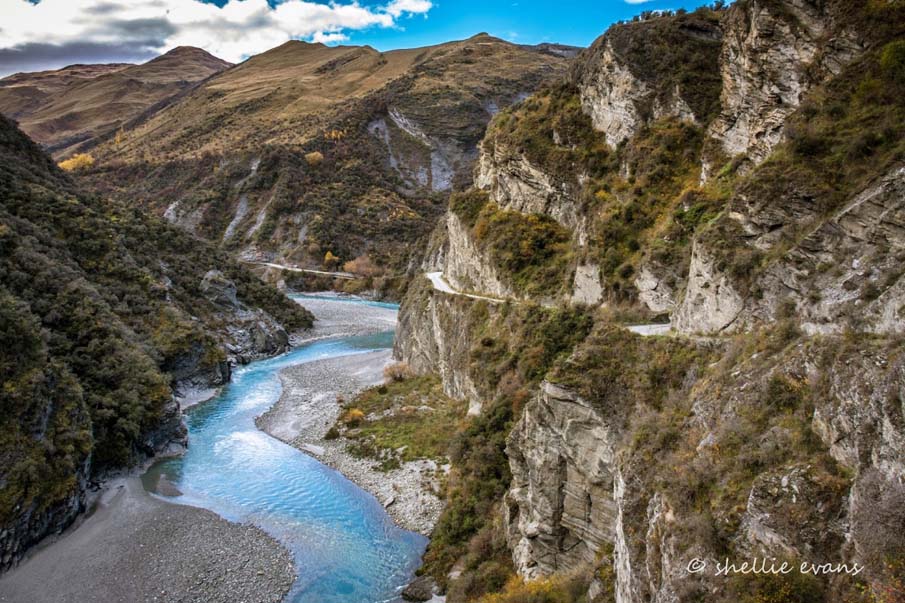
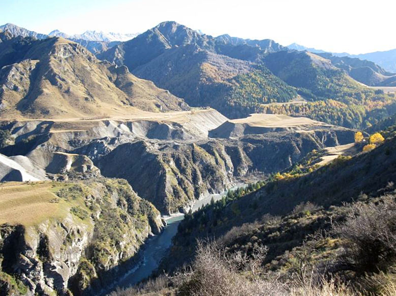
On Burkes Terrace overlooking the Kimiākau / Shotover River Gorge with Mount Aurum towering behind, is the site of the former Mt Aurum homestead and Skippers School. Dating from the gold mining period of Skipper’s history (between 1860s and 1914) when Skippers was a straggly but busy settlement, the school is the only substantial building remaining in the former township.
Skippers serviced the surrounding area with its isolated pockets of mining on nearby terraces (such as Pleasant Terrace) and further into the mountains with Bullendale and other mining operations. Since the loss of the Mt Aurum homestead in June 2018, the former Skippers School building is the only substantial building remaining that reflects the period after the initial gold mining rushes had faded. It specifically recalls the families who were integral to the pastoral history of this isolated area.
Mt Aurum Station and Skippers School site were originally included in the 100, 000-acre (40, 468 hectare) pastoral run taken up by William Gilbert Rees in the 1850s but when gold was discovered in the Kimiākau / Shotover River area in 1862 the run was cancelled and it formed part of the new gold field. A settlement grew up at Skippers, which became the focus for the many miners and prospectors working the mountainous terrain and included the school which was open between 1879 and 1927.
As gold returns declined, pastoralism was re-established. The former run was taken up by French Canadian Julien Bordeau in the mid-1870s. A succession of runholders followed him. By the 1890s, runholder Andrew Lambie and his family lived at the Mount Aurum Homestead. The conversion of the former stone schoolhouse to a woolshed for Mount Aurum Station after 1927 is reflective of the realities of a life where materials were difficult to transport and where everything was reused. Life in the isolated run was immortalised by Terri Macnicol who told her family’s story in two books which captured the essence of life in an isolated high-country station in the 1940s and 1950s. After the pastoral run was cancelled these buildings were included in the Mount Aurum Recreation Reserve when it was gazetted in 1982.
By the late 1980s, Mount Aurum Homestead and the former school had fallen into disrepair. Restored by the community and the Department of Conservation, the buildings were substantially reconstructed. Their survival for a following generation shows their continuing significance to the community. However, in January 2018 the Mt Aurum homestead was destroyed in a fire. In 2021 Skippers School is the only substantial building remaining that commemorates the history of Skippers and provides a physical focus for visitors to interpret the former town.
List Entry Information
Status
Listed
List Entry Status
Historic Place Category 2
Access
Able to Visit
List Number
5176
Date Entered
12th December 2013
Date of Effect
9th May 2022
City/District Council
Queenstown-Lakes District
Region
Otago Region
Extent of List Entry
Extent includes part of the land described as Sec 148 Blk XI Skippers Creek SD (Recreation Reserve NZ Gazette, 1985 p. 5386) and part Legal Road (Skippers Road), Otago Land District, and the building known Skippers School (Former), thereon. (Refer to map in Appendix 1 of the registration report for further information).
Legal description
Sec 148 Blk XI Skippers Creek SD (Recreation Reserve NZ Gazette, 1985, p. 5386) and part Legal Road (Skippers Road), Otago Land District
Location Description
Located immediately to the south of Burkes Terrace, and to the north of 2090 Skippers Road. Skippers School (NZTM 5587200N/2168678E);
Why is this place significant?
Cultural Significance
Social Significance or Value Restoration in the 1990s and 2011 recognises of the importance of the history of Skippers and its on-going relevance to the community. The building was reconstructed by staff and volunteers of Te Papa Atawhai / Department of Conservation, and it provides a focus for the many visitors to Skippers, and an understanding of life in the mountainous Shotover area. Since the fire that razed the adjacent Mt Aurum Homestead, the social significance of the school building has increased.
Historic Significance
Historical Significance or Value The school building represents the lives of families, children, and teachers at Skippers during its years of opening between 1879 and 1927, and after that its conversion to a woolshed represents the decline of such isolated communities. That the telegraph office was included in the school building and shows the importance of connecting Skippers to the outside world, bringing people together. The Skippers School building has social significance as a repository for the history of the Skipper’s community
Physical Significance
Aesthetic Significance or Value Skippers School (Former) sits on a prominent terrace site overlooking the spectacular Shotover River Gorge with Mount Aurum and the mass of Whakaari / Richardson Mountains standing sentinel in the background. This building, though reconstructed, recalls the lives of both gold miners and pastoralists in this spectacular and harsh environment is the most substantial structure surviving from Skippers township and in their prominent site in the dramatic landscape has aesthetic significance. Architectural Significance or Value Though reconstructed and restored, this building recalls the architectural form of nineteenth-century buildings. The school building represents the idea of stability, permanence and structure associated with educational buildings implanted into this rugged place. Local materials were used, and reused where able, a common practice in such isolated places where building materials had to be carried in. Archaeological Significance or Value The Skipper School building has archaeological significance as a rare extant example of a permanent material rural school complex in an isolated area. Archaeological study of the original fabric and layout has the potential to contribute information on the construction, aintenance, and functions of the schoolhouse, teachers’ accommodation and telegraph office to illustrate the importance of the building in servicing and maintaining a community. In addition, there is potential for associated material culture to inform on the lives of the children and teachers of this isolated settlement. In addition, archaeological study of the layout and fabric could shed light on the 20th century adaption of the building to a woolshed which is indicative of rural reuse of buildings where materials are scarce.
Why is this place Category 1 / Category 2?
Detail Of Assessed Criteria
This place was assessed against the Section 66(3) criteria and found to qualify under the following criteria b, e, f and k. The assessment concludes that this place should be listed as a Category 2 historic place. (b) The association of the place with events, persons, or ideas of importance in New Zealand history Both the homestead and the former school are associated with the gold rush and pastoral period of Otago’s history. The school relates to the lives of children, and the decline of the community as mining petered out when the former school building was incorporated into the workings of Mount Aurum Station. (e) The community association with, or public esteem for the place The community esteem for these places is illustrated through their restoration and reconstruction supported by community members and through community funding. They serve as evidence of the lives of miners in this isolated place. (f) The potential of the place for public education The former Skippers School has interpretation panels which explain and illustrate the history of life at Skippers, already providing public education. (k) The extent to which the place forms part of a wider historical and cultural area The former Skippers School is part of the wider historical landscape that was the Skippers Township, and wider still the Skippers goldfield which stretched up and down the Shotover River. There are many recorded archaeological sites which indicate the extent of the field and tell the history of mining and life in isolated Skippers. Summary of Significance or Values As the only remaining substantial historic building in the remote Skippers area, the former Skippers School contributes to New Zealand’s historic and cultural heritage. Situated in the outstanding landscape of Skippers, the building that was restored 1989-1992 has aesthetic and architectural value as an example of a school building built with local materials in the 19th century. It’s history as a school and later a woolshed tells the important story of the pastoral families who lived isolated lives in this area of Aotearoa. Its restoration and maintenance by Department of Conservation and local volunteers and its use as a place of interpretation ensures its ongoing social value as a place of learning and recreation within the Mt Aurum Recreation Reserve
Construction Professional
Name
McDonald, Dave
Type
Carpenter
Biography
No biography is currently available for this construction professional
Name
Kim Logan and Neil Milne
Type
Stonemason
Biography
No biography is currently available for this construction professional
Name
Hardie, Stewart
Type
Carpenter
Biography
No biography is currently available for this construction professional
Construction Details
Start Year
1927
Finish Year
1941
Type
Addition
Description
Woolshed
Start Year
1992
Finish Year
1993
Type
Restoration
Description
School reconstructed
Start Year
1867
Type
Original Construction
Description
Original construction of homestead
Start Year
1879
Type
Original Construction
Description
School constructed
Start Year
1884
Type
Addition
Description
Addition to the School (thought to be the two small bedrooms off the living area)
Start Year
1912
Finish Year
1917
Type
Addition
Description
Southern addition to homestead
Start Year
1992
Finish Year
1993
Type
Refurbishment/renovation
Description
School reconstructed and homestead restored
Start Year
2018
Finish Year
2018
Type
Demolished - Fire
Description
The Mt Aurum Station destroyed by a suspicious fire on 1 Jan 2018.
Construction Materials
Schoolhouse: Stone (schist), corrugated iron, timber joinery.
Early history The Wakatipu Waimāori / Lake Wakatipu and Head of the Lake area are of great significance to Kāi Tahu. A deed of recognition acknowledges the area and the cultural, spiritual, historical, and traditional significance of Wakatipu Waimāori. “The name ‘Whakatipu-wai-māori’ originates from the earliest expedition of discovery made many generations ago by the tupuna Rakaihautu and his party of the Uruao waka. Rakaihautu is traditionally credited with creating the great waterways of the interior of the island with his famous ko (a tool like a spade), known as Tu Whakaroria (renamed Tuhiraki at the conclusion of the expedition).” A tipua (demi-god/metaphysical being) named Matua is believed to live in the lake; and it is his somnolescent breathing that causes the rise and fall of the lake. Wakatipu Waimāori once supported nohoaka and villages that were the seasonal destinations of Otago and Murihiku / Southland whānau and hapū for many generations. Here they exercised ahi kā and accessed mahika kai. Wakatipu Waimāori provided a route to access the treasured īnaka and kōkopu pounamu located beyond the head of the lake. Waka and mōkihi were the key modes of transport for the pounamu trade, travelling the length and breadth of Wakatipu Waimāori. There were numerous tauraka waka (landing places) on the lake and the islands upon it (Matau and Wāwāhi Waka). Early Māori knew the Shotover River as Kimi Ākau, meaning ‘looking for the coast’, which may indicate an attempt to reach the West Coast through this route. The settlement of Skippers is located amongst Whakaari / Richardson Mountain range between Puahiri / Rees River and Kimiākau which is situated north-east of Whakatipu Waimāori / Lake Wakatipu. The tīpuna had an intimate knowledge of navigation, river routes, safe harbours and landing places, and the locations of food and other resources on the lake. The lake was an integral part of a network of trails which were used to ensure the safest journey and incorporated locations along the way that were identified for activities including camping overnight and gathering kai. Knowledge of these trails continue to be held by whānau and hapū and are regarded as taonga. Mahika kai, ‘places where food was produced or procured’, were a major focus of the Ngāi Tahu settlement and were well documented within the Wai 27 claim. The traditional mobile lifestyle of the people led to their dependence on the resources of the roto (lake). The mauri of Wakatipu Waimāori represents the essence that binds the physical and spiritual elements of all things together, generating and upholding all life. Europeans learned of the inland lakes from Māori. Chief Te Huruhuru provided Edward Shortland a map of the inland lakes in 1844. In 1853 Chief Reko of Tūtūrau guided Nathanael Chalmers inland via the Mataura River as far as Wakatipu Waimāori. Today nohoanga entitlements at the Kimiākau / Shotover River are acknowledged at Māori Point not far from the site of Skippers historic settlement. By the 1850s, the area of land later known as Mount Aurum Station formed part of a 100,000-acre lease taken up by William Gilbert Rees for farming. Yet when two Europeans named Thomas Arthur and Harry Redfern discovered gold on the Kimiākau / Shotover in November 1862, Rees’ pastoral run was cancelled. In less than two months after their original discovery, Arthur and Redfern had won £4,000 ($492,220) of gold and the rush to the ‘fabulous Shotover’ had begun. A thousand miners had flooded the Kimiākau / Shotover within a month. It was at Māori Point where gold miner Rāniera Tāheke Ellison of Te Āti Awa and Hakaria Haeroa discovered 300 ounces (8.5 kg) of gold in 1862. Internationally, the Kimiākau / Shotover became known as the second richest goldfield after the Yukon and was declared the ‘Richest River in the World. During the rushes, a community grew up at Skippers Point – hotels and stores and other services were developed on the high terraces from Skippers Point to Burkes Terrace. The Skippers township serviced the surrounding area with its isolated pockets of mining on nearby terraces (such as Pleasant Terrace) with their scattering of residences and further into the mountains with Bullendale and other mining operations. Yet the rush was short. As the gold returns declined, the settlement at Skippers shrank to a cluster of families who chose to settle more permanently, eking out an existence mining and working on the pastoral properties of the area. Land around Skippers was let under a system of depasturing licences or agricultural leases recorded by the Queenstown Warden’s Court, which maintained the rights of access for gold mining. The area around Skippers was reserved as commonage or as a town site although the town does not appear to have been officially surveyed. The hot summers, cold winters and mountainous country made life difficult for pastoralists and residents alike. Rabbits plagued the hills, the land flooded and slid. Access to the outside world was difficult and often hazardous, even after the construction of Skippers Road (List No. 7684, Category 1). Such isolation meant that everything had to be packed in, including building materials; nothing was wasted, everything was reused or adapted. Run 13 – Mount Aurum By the mid-1870s larger blocks in the area were being granted under lease. Run 13, which included 14,000 acres (5665 hectares) to the north and west of Skippers Point is recorded as being first taken up around 1874. Popularly it is written that Run 13 was taken in 1867 and that the first lessee, Julien Bordeau (1829-1916), held the run between 1867 and 1874. However, the early history of the run is difficult to trace – between 1865 and 1869 there is no application from Bordeau in the Queenstown Warden’s Court. Bordeau did apply for a 193-acre agricultural lease in January 1873, but that was in a different block. The earliest record for Run 13 therefore seems to be Bordeau’s ‘licence to occupy Crown lands for pastoral purposes’, for the 14,000-acre run and a neighbouring one in 1874. Bordeau was a well-known and colourful figure in Skippers and Queenstown. Montreal born, he came to New Zealand and to the Wakatipu district in 1863. He bought the Skippers Point Hotel, started a butchers, bakery and general storekeeper’s business as well as packing stores over the rough track between Queenstown and Skippers. His store was to the east of where the Mount Aurum Homestead would later be. In his later years he shifted to Arthurs Point where he had a store (Bordeau’s Store (List No. 2238)) before finally settling at Burkes Terrace near Skippers. He carried the mail between Queenstown and Skippers for twenty-five years. Bordeau’s run, which became known as Mount Aurum Station, was a difficult property to manage – it had little land for wintering stock and access was difficult. Over the next 100 years, it had 16 lessees, which averages out at around three years tenure per lessee. On four occasions the lessee walked off the run. The 1880s saw a particularly rapid turnover of tenants. The Runs Register records David McKinlay as tenant for Run 13 in 1880. Shepherds Thomas Davidson and Thomas Hope took up the lease in 1884. Davidson and Hope surrendered their lease early in 1886. Skippers storekeeper Henry Augustus Evans took up a fourteen-year term but transferred it to Frederick Evans (mine manager at Bullendale) in 1888. In 1890 shepherd Finlay McMillan took up the lease and held it for nine years. Andrew Lambie leased the run in 1899, adding the neighbouring runs 15 and 16. With his brother Bob and family he managed 32,000 acres (12,950 hectare). Tragically, in October 1912 Andrew’s wife Mary died, her infant son following her to the grave three months later. Andrew Lambie and the children remained on the run until 1917. Andrew Lambie died in 1923 aged 66. RM Paterson owned the run from 1917 until his death, around 1941. Paterson owned two other stations – West Dome in Southland and Ayrburn near Arrowtown. Archie Macnicol and his family took over the run after Paterson. Where did the runholders live? The runholders did not necessarily live on the run. In 1880 the Runs Register records runholder David McKinlay as a Skippers sheep farmer, but he was already living there – he had a seven-acre agricultural lease at Skippers granted in 1878. Local expert and historian, the late Peter Chandler, writes that McKinlay’s house may have been shifted to become part of Mount Aurum Homestead. An 1888 survey plan shows that the site next to Skippers School (now identified as Mount Aurum homestead) as a ‘residence area’ for a Mr Richards. The survey plan has three structures within the one-acre site. Thomas Francis Richards is recorded as a packer and labourer at Skippers 1884-1890. The New Zealand Archaeological Association Site Record Form indicates that the homestead was most likely built by Richards circa 1884, and that runholder Andrew Lambie and family lived in there once they took over the run. It is also possible that the house was already there, and that Richards took it over. The Upper Shotover School Where there were families, there was a need for a school. Upper Shotover School (known more commonly as Skippers School) was opened in 1879 near the Mt Aurum homestead. The school was a substantial stacked stone building, housing the teacher and the school, built rather optimistically for an anticipated roll of 120 pupils. Only 24 pupils were on the opening roll. A telegraph office was built in a small room on the northwest corner. In its heyday, the school had 27 pupils on its roll. However, getting (and keeping) teachers in this isolated area was a problem, with 24 teachers coming and going in the years the school was open. It was, however, an important institution in the small Skippers community that remained after the gold rushes had ceased – and it also provided a connection with the outside world through the telegraph office that was part of the building. There was an addition to the building in 1884, thought to be the two small bedrooms off the living area – having a residence provided meant teachers were more likely to accept a teaching position. In the 1897 the Southland Education Board decreed Upper Shotover School at Skippers and Skippers Reef School at Bullendale should become half-time schools, this was usually a sign of low attendance. Consequently, Lewis Sangster, the teacher at the time, was required to teach three days a week at each school. The Queenstown Courier reported; ‘The treacherous journey between the settlements took more than three hours of tramping and the track crossed and recrossed Skippers Creek about 86 times each way … Lewis was compensated financially for having to teach at two schools. In 1896 he received a salary of £60 ($12,349) for teaching 15 children at Skippers, but the next year when teaching 9 pupils at Skippers and 16 at Bullendale, he received £131 ($26,900).’ Sadly, Lewis died that Christmas while visiting his parents in Invercargill, the Lake County Press in Arrowtown reported the ‘deceased was quite a young man and an excellent teacher.’ It is conceivable that his working conditions were a contributing factor to his illness and death though this was never acknowledged. Following his death and the refusal of a newly appointed teacher, Jessie Reid, to accept the brutal working conditions requiring the weekly journey between the two schools, the Education Board provided full time teachers for both schools. Over the years the school was a place of meeting for the local community and a site of annual picnics for the wider area. By 1927 only 6 pupils attended, and the school was closed. Runholder Paterson took over the former school as a farm building to use free of charge. The Macnicol’s then converted it into a woolshed in 1941 and it was used as such until 1982. Life at Mount Aurum – The Macnicol’s Story One family’s life at Mount Aurum has given the place a special resonance for the New Zealand public. Terri Macnicol, wife of leaseholder Archie Macnicol, wrote two popular books describing the family’s life at Mount Aurum in the 1940s and 1950s. Although Terri was new to Skippers, the Macnicol family had a longer association. Archie’s grandfather, Alfred Smith, had followed the lure of gold to Skippers in the 1860s and brought his family up at Skippers Point. Archie’s father Colin had moved to the area probably around 1902. Runholder Paterson employed Duncan Macnicol, Archie’s brother as a manager on the run. Later when Duncan moved to West Dome Station, Archie followed and learnt to muster and shear, eventually becoming head shepherd at Mt Linton Station. When Mt Aurum Station was rumoured to be for sale Archie Macnicol returned to the Wakatipu. He finally took up the lease to Mt Aurum in 1940. He and his wife and their family of four children lived on the run until 1957. Mona Bobsien married Archie and came to live at Mt Aurum Homestead. Under a pseudonym she recalls her life there in Echoes of Skippers Canyon and Beyond the Skippers Road which bring to life her family’s isolated existence. They were the only permanent residents of Skippers and completely cut off in the winter – ‘[t]he homestead dwarfed by the rugged grandeur of the surrounding country appeared like a miniature doll’s house placed in the chipped, dented, rusty bottom of a white enamel bowl.’ She describes vividly the life of her family, ranging the isolated hills, the tenacity and the joy of making do. As the family grew, they moved off the run, but her books have left in place the sense of Mount Aurum Station as it was. Mount Aurum Recreation Reserve Run 13 was sold to KJ Sargison and in 1977 it was acquired by the then Lands and Survey Department. With no adequate winter country and a restricted stock carrying capacity, the run had no economic potential. Mount Aurum did, however, have a long history of public use for recreation, and these values were recognised in 1982 when the station was designated as a recreation reserve. The Department of Conservation restored (largely rebuilt) both the former school (returning it to the form it had as a school) and the homestead in the early 1990s, with community funding support for the building work and interpretation. Lakes District Museum director David Clarke said at the time that the building was ‘a lasting tribute to the pastoral history of the district.’ Work was completed by volunteers and Department of Conservation staff. The school was restored and reconstructed as well, using historic photographs to guide the construction and included reconstruction of major portions of walls. The project received funding from the New Zealand Tourism and Publicity Department’s community grants scheme. Collapsed walls were reinstated and the interior was returned to its original layout. A picket fence was erected around the original boundary of the school site. Hundreds of people gathered for its opening as a public interpretation centre in November 1992, including the oldest surviving ex-students including Duncan Macnicol, and Grace and Francis Cotter. It was reopened by the Minister of Conservation, Denis Marshall, reflecting the importance placed on recognising one of Skipper’s most significant buildings. Further restoration work was conducted on both the school and homestead by the Department of Conservation in 2011. At 12.20am on New Year’s Day 2018, fire was spotted by campers at the recreational reserve. Shortly after, the Mt Aurum Homestead and adjacent washhouse were razed to the ground. While the original coal range chimney and the schist chimney built by the Department of Conservation in the 1990s survived, they have since been demolished. A fire investigator “… could not determine the exact cause of the fire as the statements of the two people last known to be in the building did not match other evidence.” The fire was so fierce a point of origin could not be determined. “Department of Conservation Wanaka operations manager Geoff Owen, who visited the site on Monday, said he was "absolutely devastated" for himself, the families who had a connection with the 155-year-old building, and the staff and volunteers who had worked on it.” Families with historical and enduring associations with the homestead were reported to be angry and upset to see the loss of the building. The fire destroyed the homestead and its outbuildings completely, resulting in a loss of aesthetic values, physical fabric and the degradation of its archaeological value. In 2021 the former Upper Shotover School (Skippers School) remains a focal point for commemorating the history of Skippers Point remembering the lives of pastoralists and gold miners in this isolated and spectacular setting within the Skippers campsite in the Mt Aurum Recreational Reserve.
Early history The Wakatipu Waimāori / Lake Wakatipu and Head of the Lake area are of great significance to Kāi Tahu. A deed of recognition acknowledges the area and the cultural, spiritual, historical, and traditional significance of Wakatipu Waimāori. “The name ‘Whakatipu-wai-māori’ originates from the earliest expedition of discovery made many generations ago by the tupuna Rakaihautu and his party of the Uruao waka. Rakaihautu is traditionally credited with creating the great waterways of the interior of the island with his famous ko (a tool like a spade), known as Tu Whakaroria (renamed Tuhiraki at the conclusion of the expedition).” A tipua (demi-god/metaphysical being) named Matua is believed to live in the lake; and it is his somnolescent breathing that causes the rise and fall of the lake. Wakatipu Waimāori once supported nohoaka and villages that were the seasonal destinations of Otago and Murihiku / Southland whānau and hapū for many generations. Here they exercised ahi kā and accessed mahika kai. Wakatipu Waimāori provided a route to access the treasured īnaka and kōkopu pounamu located beyond the head of the lake. Waka and mōkihi were the key modes of transport for the pounamu trade, travelling the length and breadth of Wakatipu Waimāori. There were numerous tauraka waka (landing places) on the lake and the islands upon it (Matau and Wāwāhi Waka). Early Māori knew the Shotover River as Kimi Ākau, meaning ‘looking for the coast’, which may indicate an attempt to reach the West Coast through this route. The settlement of Skippers is located amongst Whakaari / Richardson Mountain range between Puahiri / Rees River and Kimiākau which is situated north-east of Whakatipu Waimāori / Lake Wakatipu. The tīpuna had an intimate knowledge of navigation, river routes, safe harbours and landing places, and the locations of food and other resources on the lake. The lake was an integral part of a network of trails which were used to ensure the safest journey and incorporated locations along the way that were identified for activities including camping overnight and gathering kai. Knowledge of these trails continue to be held by whānau and hapū and are regarded as taonga. Mahika kai, ‘places where food was produced or procured’, were a major focus of the Ngāi Tahu settlement and were well documented within the Wai 27 claim. The traditional mobile lifestyle of the people led to their dependence on the resources of the roto (lake). The mauri of Wakatipu Waimāori represents the essence that binds the physical and spiritual elements of all things together, generating and upholding all life. Europeans learned of the inland lakes from Māori. Chief Te Huruhuru provided Edward Shortland a map of the inland lakes in 1844. In 1853 Chief Reko of Tūtūrau guided Nathanael Chalmers inland via the Mataura River as far as Wakatipu Waimāori. Today nohoanga entitlements at the Kimiākau / Shotover River are acknowledged at Māori Point not far from the site of Skippers historic settlement. By the 1850s, the area of land later known as Mount Aurum Station formed part of a 100,000-acre lease taken up by William Gilbert Rees for farming. Yet when two Europeans named Thomas Arthur and Harry Redfern discovered gold on the Kimiākau / Shotover in November 1862, Rees’ pastoral run was cancelled. In less than two months after their original discovery, Arthur and Redfern had won £4,000 ($492,220) of gold and the rush to the ‘fabulous Shotover’ had begun. A thousand miners had flooded the Kimiākau / Shotover within a month. It was at Māori Point where gold miner Rāniera Tāheke Ellison of Te Āti Awa and Hakaria Haeroa discovered 300 ounces (8.5 kg) of gold in 1862. Internationally, the Kimiākau / Shotover became known as the second richest goldfield after the Yukon and was declared the ‘Richest River in the World. During the rushes, a community grew up at Skippers Point – hotels and stores and other services were developed on the high terraces from Skippers Point to Burkes Terrace. The Skippers township serviced the surrounding area with its isolated pockets of mining on nearby terraces (such as Pleasant Terrace) with their scattering of residences and further into the mountains with Bullendale and other mining operations. Yet the rush was short. As the gold returns declined, the settlement at Skippers shrank to a cluster of families who chose to settle more permanently, eking out an existence mining and working on the pastoral properties of the area. Land around Skippers was let under a system of depasturing licences or agricultural leases recorded by the Queenstown Warden’s Court, which maintained the rights of access for gold mining. The area around Skippers was reserved as commonage or as a town site although the town does not appear to have been officially surveyed. The hot summers, cold winters and mountainous country made life difficult for pastoralists and residents alike. Rabbits plagued the hills, the land flooded and slid. Access to the outside world was difficult and often hazardous, even after the construction of Skippers Road (List No. 7684, Category 1). Such isolation meant that everything had to be packed in, including building materials; nothing was wasted, everything was reused or adapted. Run 13 – Mount Aurum By the mid-1870s larger blocks in the area were being granted under lease. Run 13, which included 14,000 acres (5665 hectares) to the north and west of Skippers Point is recorded as being first taken up around 1874. Popularly it is written that Run 13 was taken in 1867 and that the first lessee, Julien Bordeau (1829-1916), held the run between 1867 and 1874. However, the early history of the run is difficult to trace – between 1865 and 1869 there is no application from Bordeau in the Queenstown Warden’s Court. Bordeau did apply for a 193-acre agricultural lease in January 1873, but that was in a different block. The earliest record for Run 13 therefore seems to be Bordeau’s ‘licence to occupy Crown lands for pastoral purposes’, for the 14,000-acre run and a neighbouring one in 1874. Bordeau was a well-known and colourful figure in Skippers and Queenstown. Montreal born, he came to New Zealand and to the Wakatipu district in 1863. He bought the Skippers Point Hotel, started a butchers, bakery and general storekeeper’s business as well as packing stores over the rough track between Queenstown and Skippers. His store was to the east of where the Mount Aurum Homestead would later be. In his later years he shifted to Arthurs Point where he had a store (Bordeau’s Store (List No. 2238)) before finally settling at Burkes Terrace near Skippers. He carried the mail between Queenstown and Skippers for twenty-five years. Bordeau’s run, which became known as Mount Aurum Station, was a difficult property to manage – it had little land for wintering stock and access was difficult. Over the next 100 years, it had 16 lessees, which averages out at around three years tenure per lessee. On four occasions the lessee walked off the run. The 1880s saw a particularly rapid turnover of tenants. The Runs Register records David McKinlay as tenant for Run 13 in 1880. Shepherds Thomas Davidson and Thomas Hope took up the lease in 1884. Davidson and Hope surrendered their lease early in 1886. Skippers storekeeper Henry Augustus Evans took up a fourteen-year term but transferred it to Frederick Evans (mine manager at Bullendale) in 1888. In 1890 shepherd Finlay McMillan took up the lease and held it for nine years. Andrew Lambie leased the run in 1899, adding the neighbouring runs 15 and 16. With his brother Bob and family he managed 32,000 acres (12,950 hectare). Tragically, in October 1912 Andrew’s wife Mary died, her infant son following her to the grave three months later. Andrew Lambie and the children remained on the run until 1917. Andrew Lambie died in 1923 aged 66. RM Paterson owned the run from 1917 until his death, around 1941. Paterson owned two other stations – West Dome in Southland and Ayrburn near Arrowtown. Archie Macnicol and his family took over the run after Paterson. Where did the runholders live? The runholders did not necessarily live on the run. In 1880 the Runs Register records runholder David McKinlay as a Skippers sheep farmer, but he was already living there – he had a seven-acre agricultural lease at Skippers granted in 1878. Local expert and historian, the late Peter Chandler, writes that McKinlay’s house may have been shifted to become part of Mount Aurum Homestead. An 1888 survey plan shows that the site next to Skippers School (now identified as Mount Aurum homestead) as a ‘residence area’ for a Mr Richards. The survey plan has three structures within the one-acre site. Thomas Francis Richards is recorded as a packer and labourer at Skippers 1884-1890. The New Zealand Archaeological Association Site Record Form indicates that the homestead was most likely built by Richards circa 1884, and that runholder Andrew Lambie and family lived in there once they took over the run. It is also possible that the house was already there, and that Richards took it over. The Upper Shotover School Where there were families, there was a need for a school. Upper Shotover School (known more commonly as Skippers School) was opened in 1879 near the Mt Aurum homestead. The school was a substantial stacked stone building, housing the teacher and the school, built rather optimistically for an anticipated roll of 120 pupils. Only 24 pupils were on the opening roll. A telegraph office was built in a small room on the northwest corner. In its heyday, the school had 27 pupils on its roll. However, getting (and keeping) teachers in this isolated area was a problem, with 24 teachers coming and going in the years the school was open. It was, however, an important institution in the small Skippers community that remained after the gold rushes had ceased – and it also provided a connection with the outside world through the telegraph office that was part of the building. There was an addition to the building in 1884, thought to be the two small bedrooms off the living area – having a residence provided meant teachers were more likely to accept a teaching position. In the 1897 the Southland Education Board decreed Upper Shotover School at Skippers and Skippers Reef School at Bullendale should become half-time schools, this was usually a sign of low attendance. Consequently, Lewis Sangster, the teacher at the time, was required to teach three days a week at each school. The Queenstown Courier reported; ‘The treacherous journey between the settlements took more than three hours of tramping and the track crossed and recrossed Skippers Creek about 86 times each way … Lewis was compensated financially for having to teach at two schools. In 1896 he received a salary of £60 ($12,349) for teaching 15 children at Skippers, but the next year when teaching 9 pupils at Skippers and 16 at Bullendale, he received £131 ($26,900).’ Sadly, Lewis died that Christmas while visiting his parents in Invercargill, the Lake County Press in Arrowtown reported the ‘deceased was quite a young man and an excellent teacher.’ It is conceivable that his working conditions were a contributing factor to his illness and death though this was never acknowledged. Following his death and the refusal of a newly appointed teacher, Jessie Reid, to accept the brutal working conditions requiring the weekly journey between the two schools, the Education Board provided full time teachers for both schools. Over the years the school was a place of meeting for the local community and a site of annual picnics for the wider area. By 1927 only 6 pupils attended, and the school was closed. Runholder Paterson took over the former school as a farm building to use free of charge. The Macnicol’s then converted it into a woolshed in 1941 and it was used as such until 1982. Life at Mount Aurum – The Macnicol’s Story One family’s life at Mount Aurum has given the place a special resonance for the New Zealand public. Terri Macnicol, wife of leaseholder Archie Macnicol, wrote two popular books describing the family’s life at Mount Aurum in the 1940s and 1950s. Although Terri was new to Skippers, the Macnicol family had a longer association. Archie’s grandfather, Alfred Smith, had followed the lure of gold to Skippers in the 1860s and brought his family up at Skippers Point. Archie’s father Colin had moved to the area probably around 1902. Runholder Paterson employed Duncan Macnicol, Archie’s brother as a manager on the run. Later when Duncan moved to West Dome Station, Archie followed and learnt to muster and shear, eventually becoming head shepherd at Mt Linton Station. When Mt Aurum Station was rumoured to be for sale Archie Macnicol returned to the Wakatipu. He finally took up the lease to Mt Aurum in 1940. He and his wife and their family of four children lived on the run until 1957. Mona Bobsien married Archie and came to live at Mt Aurum Homestead. Under a pseudonym she recalls her life there in Echoes of Skippers Canyon and Beyond the Skippers Road which bring to life her family’s isolated existence. They were the only permanent residents of Skippers and completely cut off in the winter – ‘[t]he homestead dwarfed by the rugged grandeur of the surrounding country appeared like a miniature doll’s house placed in the chipped, dented, rusty bottom of a white enamel bowl.’ She describes vividly the life of her family, ranging the isolated hills, the tenacity and the joy of making do. As the family grew, they moved off the run, but her books have left in place the sense of Mount Aurum Station as it was. Mount Aurum Recreation Reserve Run 13 was sold to KJ Sargison and in 1977 it was acquired by the then Lands and Survey Department. With no adequate winter country and a restricted stock carrying capacity, the run had no economic potential. Mount Aurum did, however, have a long history of public use for recreation, and these values were recognised in 1982 when the station was designated as a recreation reserve. The Department of Conservation restored (largely rebuilt) both the former school (returning it to the form it had as a school) and the homestead in the early 1990s, with community funding support for the building work and interpretation. Lakes District Museum director David Clarke said at the time that the building was ‘a lasting tribute to the pastoral history of the district.’ Work was completed by volunteers and Department of Conservation staff. The school was restored and reconstructed as well, using historic photographs to guide the construction and included reconstruction of major portions of walls. The project received funding from the New Zealand Tourism and Publicity Department’s community grants scheme. Collapsed walls were reinstated and the interior was returned to its original layout. A picket fence was erected around the original boundary of the school site. Hundreds of people gathered for its opening as a public interpretation centre in November 1992, including the oldest surviving ex-students including Duncan Macnicol, and Grace and Francis Cotter. It was reopened by the Minister of Conservation, Denis Marshall, reflecting the importance placed on recognising one of Skipper’s most significant buildings. Further restoration work was conducted on both the school and homestead by the Department of Conservation in 2011. At 12.20am on New Year’s Day 2018, fire was spotted by campers at the recreational reserve. Shortly after, the Mt Aurum Homestead and adjacent washhouse were razed to the ground. While the original coal range chimney and the schist chimney built by the Department of Conservation in the 1990s survived, they have since been demolished. A fire investigator “… could not determine the exact cause of the fire as the statements of the two people last known to be in the building did not match other evidence.” The fire was so fierce a point of origin could not be determined. “Department of Conservation Wanaka operations manager Geoff Owen, who visited the site on Monday, said he was "absolutely devastated" for himself, the families who had a connection with the 155-year-old building, and the staff and volunteers who had worked on it.” Families with historical and enduring associations with the homestead were reported to be angry and upset to see the loss of the building. The fire destroyed the homestead and its outbuildings completely, resulting in a loss of aesthetic values, physical fabric and the degradation of its archaeological value. In 2021 the former Upper Shotover School (Skippers School) remains a focal point for commemorating the history of Skippers Point remembering the lives of pastoralists and gold miners in this isolated and spectacular setting within the Skippers campsite in the Mt Aurum Recreational Reserve.
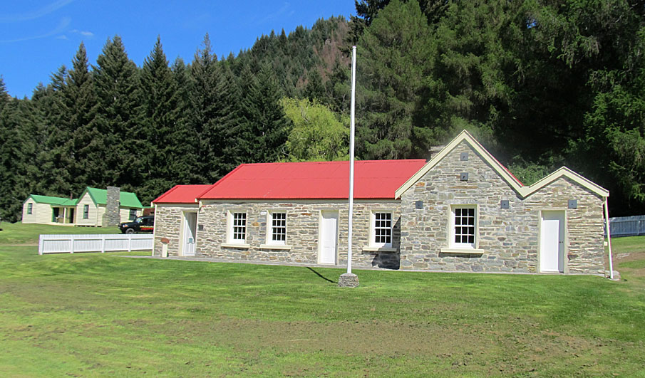
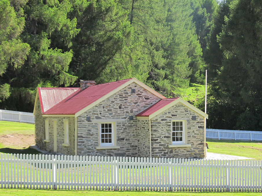
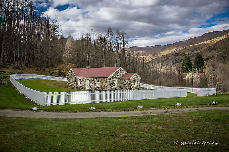
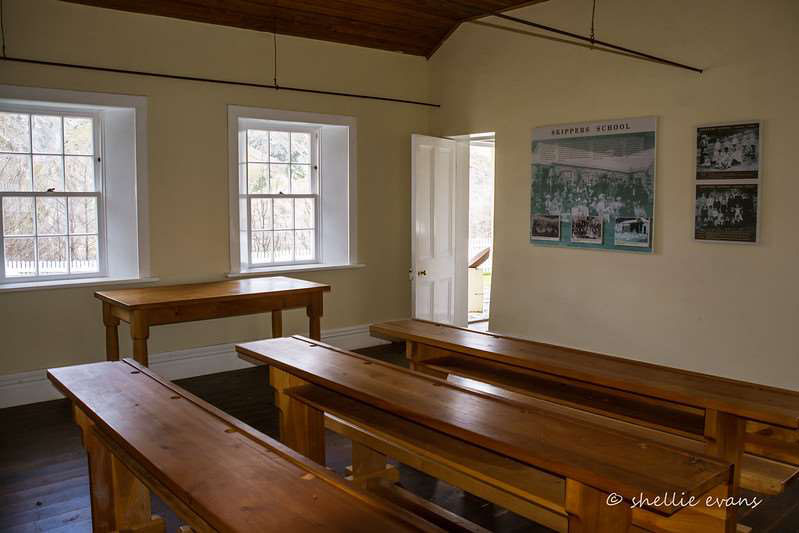
Current Description Setting The Skippers School sits in a commanding position on Burkes Terrace at Skippers. When the school and other buildings that once inhabited the terrace were built the area was a treeless landscape. Wilding pines have colonised the surrounding land and now these buildings are surrounded by tall trees. Behind the mountains tower and in front, the Kimiākau / Shotover River runs below Burkes Terrace through its steep gorge. The area is spectacular, as Department of Conservation notes, the location is among ‘the most scenically stunning spot in the country.’ Upper Shotover School (commonly known as Skippers School (Former), also the former Mount Aurum Station Woolshed) Skippers School is in a clearing on Burkes Terrace, originally part of the scattering of buildings that made Skippers township which stretched from Skippers Point to Burkes Terrace. The building is in a prominent position and can be seen from a distance. The school building is now the most significant structure surviving in the Skippers area. The other remnants of the township include the nearby Skippers Cemetery and the ruins of the Otago Hotel, as well as many archaeological remains indicating mining or residence areas. Further away, on Pleasant Terrace, is Sainsbury’s House. Although the school has been substantially reconstructed, its survival represents the architecture and building methods of the period as well as the people and the history of the area. It is a focal point for visitors to this isolated place who come to enjoy the Mt Aurum Recreation Reserve. The school represents the history of pastoralists in the Skippers area, and is a memorial to teachers and children who attended for the 48 years the school was open. It is a focal point for visitors to Skippers, more so since the homestead is gone, the old school provides an interpretation centre and insight into the way of life for residents of this isolated area. Beyond the extent of the listing, there are other ruins, mining remains, recorded archaeological sites, and the nearby cemetery; these structures make up part of the extensive historic landscape of Skippers. The building is T-shaped in plan. It is constructed of stacked stone with a corrugated iron roof. It is surrounded by a picket fence which marks the original boundary of the school grounds. The building was reconstructed in 1992 using much new material. The reconstruction shows the value the community placed on the history and physical form of the structure, and its importance to the Skippers area. The school is built of schist stone, with timber joinery, including multi-pane sash windows and timber floors. The building has an entrance porch, school room, hall, three bedrooms, a kitchen, living room and telegraph office. The school is the most substantial structure left in the Skippers area. The school originally comprised of a schoolhouse and school master’s residence combined. It also had a telegraph room at one end. It was substantially rebuilt during its restoration in 1992 when it was taken back to its form as a school. The school is the only early school in an isolated part of the Wakatipu district which remains to tell the story of education during this period. The building houses an interpretation centre which provides information into the lives of Skippers residents and of the children of Upper Shotover School.
Current Description Setting The Skippers School sits in a commanding position on Burkes Terrace at Skippers. When the school and other buildings that once inhabited the terrace were built the area was a treeless landscape. Wilding pines have colonised the surrounding land and now these buildings are surrounded by tall trees. Behind the mountains tower and in front, the Kimiākau / Shotover River runs below Burkes Terrace through its steep gorge. The area is spectacular, as Department of Conservation notes, the location is among ‘the most scenically stunning spot in the country.’ Upper Shotover School (commonly known as Skippers School (Former), also the former Mount Aurum Station Woolshed) Skippers School is in a clearing on Burkes Terrace, originally part of the scattering of buildings that made Skippers township which stretched from Skippers Point to Burkes Terrace. The building is in a prominent position and can be seen from a distance. The school building is now the most significant structure surviving in the Skippers area. The other remnants of the township include the nearby Skippers Cemetery and the ruins of the Otago Hotel, as well as many archaeological remains indicating mining or residence areas. Further away, on Pleasant Terrace, is Sainsbury’s House. Although the school has been substantially reconstructed, its survival represents the architecture and building methods of the period as well as the people and the history of the area. It is a focal point for visitors to this isolated place who come to enjoy the Mt Aurum Recreation Reserve. The school represents the history of pastoralists in the Skippers area, and is a memorial to teachers and children who attended for the 48 years the school was open. It is a focal point for visitors to Skippers, more so since the homestead is gone, the old school provides an interpretation centre and insight into the way of life for residents of this isolated area. Beyond the extent of the listing, there are other ruins, mining remains, recorded archaeological sites, and the nearby cemetery; these structures make up part of the extensive historic landscape of Skippers. The building is T-shaped in plan. It is constructed of stacked stone with a corrugated iron roof. It is surrounded by a picket fence which marks the original boundary of the school grounds. The building was reconstructed in 1992 using much new material. The reconstruction shows the value the community placed on the history and physical form of the structure, and its importance to the Skippers area. The school is built of schist stone, with timber joinery, including multi-pane sash windows and timber floors. The building has an entrance porch, school room, hall, three bedrooms, a kitchen, living room and telegraph office. The school is the most substantial structure left in the Skippers area. The school originally comprised of a schoolhouse and school master’s residence combined. It also had a telegraph room at one end. It was substantially rebuilt during its restoration in 1992 when it was taken back to its form as a school. The school is the only early school in an isolated part of the Wakatipu district which remains to tell the story of education during this period. The building houses an interpretation centre which provides information into the lives of Skippers residents and of the children of Upper Shotover School.
Historical and Associated Iwi / Hapū / Whānau
Public NZAA Number
E41/72
Completion Date
28th March 2022
Report Written By
Sarah Gallagher and Heather Bauchop
Information Sources
De La Mare, 1993
A.J. De La Mare, The Shotover River - 'The Richest River in the World': A History of Gold Mining on the Shotover River, Lakes District Museum, Arrowtown, 1993
Macnicol, 1965
T. Macnicol, Beyond the Skippers Road, Reed, Wellington 1965
Otago Daily Times
Otago Daily Times, 1 Jun 1915, p.10.
Otago Witness
Otago Witness
Southland Times
Southland Times
Press
Press, 17 May 1915, p.9.
Hamel, 2001
Jill Hamel, The Archaeology of Otago, Department of Conservation, Wellington, 2001
Queenstown Courier
Queenstown Courier
Gillies, 1993
Jackie Gillies, ‘Mount Aurum Homestead, Mount Aurum Recreation Reserve, Skippers, Queenstown, Conservation Plan 1993’ prepared for the Department of Conservation, 20 Dec 1993.
Macnicol, 1987
Duncan Macnicol and Margaret Trotter, I, Duncan from Skippers, Invercargill, 1987
Peat, 1993
Neville Peat, ‘New Life for an Old School’, New Zealand Historic Places, Jul 1993, no.42: 31.
Queenstown Lakes District Council
Queenstown Lakes District Council, Heritage Inventory Register, 1 June 2016 https://www.qldc.govt.nz/media/1aonbtgk/qldc-heritage-inventory-register-june-2016.pdf
Other Information
A fully referenced copy of the registration report is available on request from the Otago/Southland Office of Heritage New Zealand Pouhere Taonga Disclaimer Please note that entry on the New Zealand Heritage List/Rārangi Kōrero identifies only the heritage values of the property concerned and should not be construed as advice on the state of the property, or as a comment of its soundness or safety, including in regard to earthquake risk, safety in the event of fire, or insanitary conditions. Archaeological sites are protected by the Heritage New Zealand Pouhere Taonga Act 2014, regardless of whether they are entered on the New Zealand Heritage List/Rārangi Kōrero or not. Archaeological sites include ‘places associated with pre-1900 human activity, where there may be evidence relating to the history of New Zealand’. This List entry report should not be read as a statement on whether or not the archaeological provisions of the Act apply to the property (s) concerned. Please contact your local Heritage New Zealand office for archaeological advice.
Current Usages
Uses: Civic Facilities
Specific Usage: Historic Property
Former Usages
General Usage: Agriculture
Specific Usage: Woolshed/Shearing Shed
General Usage: Education
Specific Usage: School
Current Usages
Uses: Civic Facilities
Specific Usage: Historic Property
Former Usages
General Usage: Agriculture
Specific Usage: Woolshed/Shearing Shed
General Usage: Education
Specific Usage: School
Location
Related listings
Sign up to hear more
Get the latest heritage news, features and events delivered
straight to your inbox.
